Leo Belgicus - Netherlands in the shape of a lion, by Hendrik Floris van Langren - Cornelis Claesz before1609
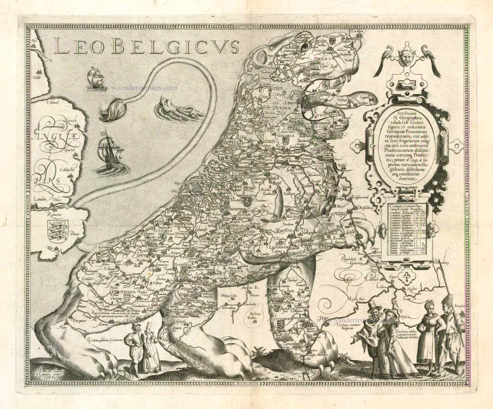
The Leo Belgicus map that Hendrik Floris van Langren engraved is one of the earliest examples of a map depicting the Seventeen Provinces in the shape of a lion. The Leo Belgicus is an allegory for the courage and perseverance of the Dutch provinces in their resistance to suppression by the Spanish. The Austrian Michael Aitsinger introduced the idea behind an image in this form in his book on the Dutch revolt, De Leone Belgico (Cologne, 1583). Aitsinger envisioned the Netherlands fighting like a lion against a powerful Spain. The oldest Leo Belgicus map is included in Aitsinger's work, engraved by Frans Hogenberg. The map became a great success in this shape and was soon copied by various mapmakers. The title on Van Langren's map is placed in the stippled sea, which is decorated with two ships and a sea monster. In the right upper corner is an oval scrollwork cartouche with the following (here translated) Latin text: "A skilfully made geographical map representing the Seventeen Provinces of the Netherlands in the form of a lion, showing also the coats of arms of the provinces, their boundaries and their governors, as defined and appointed by the supreme authorities in 1559'. The rectangular cartouche below this text lists towns and villages per province. Along the bottom, three Dutch-costumed couples are shown. The engraver is mentioned as Henricus Florentij à Langren sculpsit in the bottom left corner. Hendrik Floris van Langren was active as an engraver of maps between 1592 and 1604, working frequently also for Cornelis Claesz. This copperplate is likely to have been published by Cornelis Claesz. In his Const ende Caert-Register of 1609, the following note can be found: 'Leeuw Caerten met Gouverneurs en steden' [Lions maps with governors and towns]. It appears also from this catalogue that the portraits and town plans had to be mounted along the map's borders. For two stuivers, he offered: 'All Governors of the Netherlands, for placing below maps'. Indeed, the Würzburg copy of Van Langren's Leo Belgicus is framed by pasted strips with portraits, plans and town views. The top and bottom borders of the map contain medallions with the portraits of the various governors ruling over both parts of the Netherlands. At the two side borders, the map is bordered by a double strip containing plans and town views of several cities in the Netherlands. Schilder does not exclude the possibility that this Van Langren map was published before 1598 when Joannes van Doetecum's map appeared. The cartouche text is nearly identical to the one by Van Langren, even the announcement concerning the governors. (Schilder 7). After Cornelis Claesz's death in 1609, the copperplate of the Leo Belgicus came into Pieter van den Keere's possession. He made some revisions. Van den Keere erased the engraver's name and added his own name as publisher. A small scale bar was added to a simple cartouche in the top right corner. Graduation of degrees of longitude and latitude replaced the small decorative border of the original plate.
Langren
The Langren families were Dutch cartographers and globemakers. They worked together, often with Jacob as author and publisher and the sons as engravers.
Jacob Floris van Langren (Arnhem, before 1525 - Alkmaar, 1610)
He settled in Amsterdam as an engraver in the 1580s and worked as a globemaker in competition with others such as Hondius and Blaeu. When he retired to Alkmaar in 1600, his son, Arnold, took over the company.
Arnold van Langren (c. 1571-1644)
Engraver and globemaker, son of Jacob Floris with whom he worked, studied under Tycho Brahe. He worked with his brother Hendrik for various publishers, including Cornelius Claesz and Johann Baptist Vrients.
Michael Florent van Langren (Langrenus) (1598-1675)
Mathematician, geographer, and cosmographer to Philip IV of Spain. Son and successor to Arnold Floris. His innovations included numerical map scales, canal plans, and improvements to the Antwerp harbours and sewage system.
Hendrik Floris van Langren (c. 1574-1648)
Engraver, son of Jacob Floris above, worked alone and with his brother Arnold Florent.
Cornelis Claesz.
Printer and bookseller in Amsterdam, 1580-1609. He is famous for publishing maps, pilot guides, and atlases in the beginning period of the development of cartography in the northern Netherlands. He is noted for his co-operation with the cartographer Petrus Plancius and his editions of voyages. After 1590, the works of Lucas Jansz. He published Waghenaer, and in 1599, he acquired the publication rights of Barent Langenes’ Caert-thresoor.
Leo Belgicus
Item Number: 11609 Authenticity Guarantee
Category: Antique maps > Curiosities
Leo Belgicus - Netherlands in the shape of a lion, by Hendrik Floris van Langren - Cornelis Claesz.
Title: Leo Belgicus
Date: before1609.
Copper engraving, printed on paper.
Size (not including margins): 375 x 455mm (14.76 x 17.91 inches).
Verso: Blank.
Condition: Trace of an old faint horizontal fold; otherwise, excellent.
Condition Rating: A.
Separate publication.
Extremely rare. Schilder quotes only four copies of this first state, two of which have an unknown present location.
The Leo Belgicus map that Hendrik Floris van Langren engraved is one of the earliest examples of a map depicting the Seventeen Provinces in the shape of a lion. The Leo Belgicus is an allegory for the courage and perseverance of the Dutch provinces in their resistance to suppression by the Spanish. The Austrian Michael Aitsinger introduced the idea behind an image in this form in his book on the Dutch revolt, De Leone Belgico (Cologne, 1583). Aitsinger envisioned the Netherlands fighting like a lion against a powerful Spain. The oldest Leo Belgicus map is included in Aitsinger's work, engraved by Frans Hogenberg. The map became a great success in this shape and was soon copied by various mapmakers. The title on Van Langren's map is placed in the stippled sea, which is decorated with two ships and a sea monster. In the right upper corner is an oval scrollwork cartouche with the following (here translated) Latin text: "A skilfully made geographical map representing the Seventeen Provinces of the Netherlands in the form of a lion, showing also the coats of arms of the provinces, their boundaries and their governors, as defined and appointed by the supreme authorities in 1559'. The rectangular cartouche below this text lists towns and villages per province. Along the bottom, three Dutch-costumed couples are shown. The engraver is mentioned as Henricus Florentij à Langren sculpsit in the bottom left corner. Hendrik Floris van Langren was active as an engraver of maps between 1592 and 1604, working frequently also for Cornelis Claesz. This copperplate is likely to have been published by Cornelis Claesz. In his Const ende Caert-Register of 1609, the following note can be found: 'Leeuw Caerten met Gouverneurs en steden' [Lions maps with governors and towns]. It appears also from this catalogue that the portraits and town plans had to be mounted along the map's borders. For two stuivers, he offered: 'All Governors of the Netherlands, for placing below maps'. Indeed, the Würzburg copy of Van Langren's Leo Belgicus is framed by pasted strips with portraits, plans and town views. The top and bottom borders of the map contain medallions with the portraits of the various governors ruling over both parts of the Netherlands. At the two side borders, the map is bordered by a double strip containing plans and town views of several cities in the Netherlands. Schilder does not exclude the possibility that this Van Langren map was published before 1598 when Joannes van Doetecum's map appeared. The cartouche text is nearly identical to the one by Van Langren, even the announcement concerning the governors. (Schilder 7). After Cornelis Claesz's death in 1609, the copperplate of the Leo Belgicus came into Pieter van den Keere's possession. He made some revisions. Van den Keere erased the engraver's name and added his own name as publisher. A small scale bar was added to a simple cartouche in the top right corner. Graduation of degrees of longitude and latitude replaced the small decorative border of the original plate.
Langren
The Langren families were Dutch cartographers and globemakers. They worked together, often with Jacob as author and publisher and the sons as engravers.
Jacob Floris van Langren (Arnhem, before 1525 - Alkmaar, 1610)
He settled in Amsterdam as an engraver in the 1580s and worked as a globemaker in competition with others such as Hondius and Blaeu. When he retired to Alkmaar in 1600, his son, Arnold, took over the company.
Arnold van Langren (c. 1571-1644)
Engraver and globemaker, son of Jacob Floris with whom he worked, studied under Tycho Brahe. He worked with his brother Hendrik for various publishers, including Cornelius Claesz and Johann Baptist Vrients.
Michael Florent van Langren (Langrenus) (1598-1675)
Mathematician, geographer, and cosmographer to Philip IV of Spain. Son and successor to Arnold Floris. His innovations included numerical map scales, canal plans, and improvements to the Antwerp harbours and sewage system.
Hendrik Floris van Langren (c. 1574-1648)
Engraver, son of Jacob Floris above, worked alone and with his brother Arnold Florent.
Cornelis Claesz.
Printer and bookseller in Amsterdam, 1580-1609. He is famous for publishing maps, pilot guides, and atlases in the beginning period of the development of cartography in the northern Netherlands. He is noted for his co-operation with the cartographer Petrus Plancius and his editions of voyages. After 1590, the works of Lucas Jansz. He published Waghenaer, and in 1599, he acquired the publication rights of Barent Langenes’ Caert-thresoor.


