
Sea monsters, by Sebastian Münster. 1568
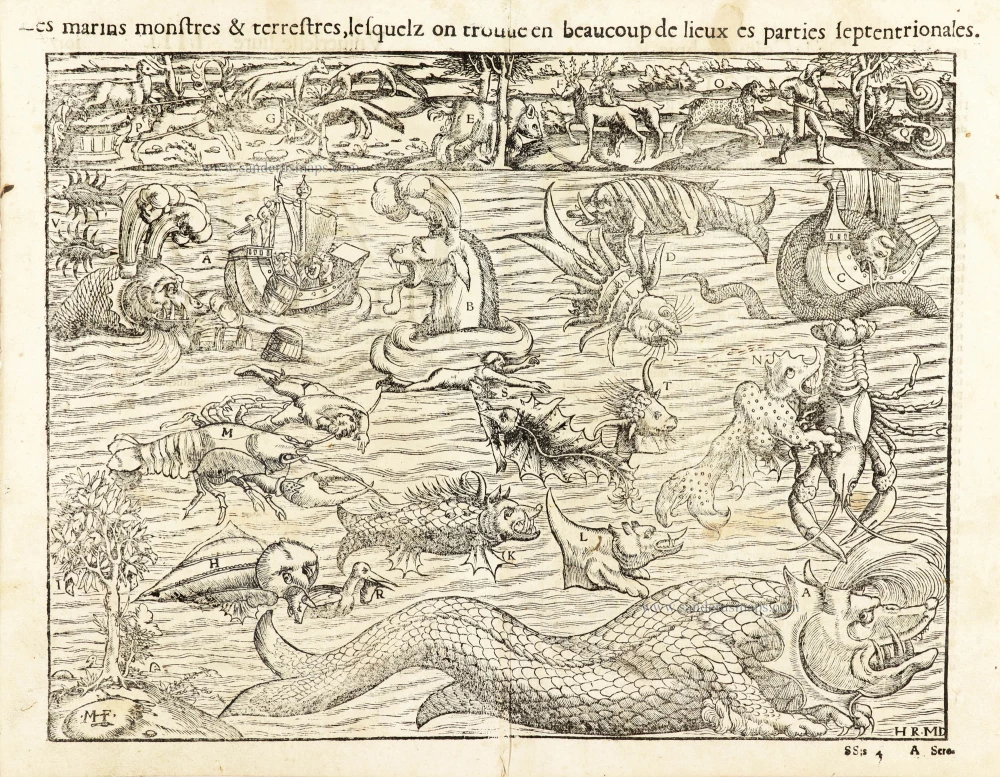
In the early days of the era of discoveries, many ships would depart and never be seen again. Sailors that managed to return used to speak of encounters with large fish that expelled water. These were included with a long series of sea monsters blamed for the missing vessels and sailors. This plate shows some of these monsters. They are based on the accounts of mariners and the draftsmen's imagination. Every letter corresponds to a description of the danger entailed and is explained in the chart of sea monsters published in the Cosmographia. We can see a scene depicting a caravel from which barrels with food are thrown while trumpets are blown to calm down a monster (whale). We can also see serpents that, according to mariners' beliefs of the time, could overturn ships. At the top, we find the terrestrial world, which has known animals such as bears and deer.
Most of the monsters shown here are found in Olaus Magnus' map of northern Europe and adjacent waters, published in 1539; Münsters's popular cosmography, however, was probably the immediate source of the sea monsters that decorate and enliven the charts of many European mapmakers in the latter half of the sixteenth century.
Sebastian Münster (1488-1552)
Sebastian Münster, a German geographer, cartographer, Hebraist, and theologian, was born in Ingelheim, near Mainz In 1505, he went to Heidelberg to enter the Franciscan order. In 1507 he went to Louvain, where he studied mathematics, geography, and astronomy. In 1509 Münster became a student of Konrad Pelikan, who taught Hebrew and Greek as well as mathematics and cosmography. In 1518 he completed his studies at the University of Tübingen. He was the favorite of the famous mathematician and astronomer Johann Stöffler.
In 1524 Münster was appointed professor of Hebrew at Heidelberg University. In 1525 he published his first map as part of a broadside: The Instrument of the Suns combined a map, calendar, astrological almanac, sundial, and nocturnal on one attractive sheet, suitable for wall mounting.
In 1540 he published a Latin edition of Ptolemy's Geographia with illustrations. He based this edition on the Latin translation by Willibald Pirkheimer and produced new maps to supplement the Ptolemaic maps. The twenty-seven maps of the Ptolemaic canon are supplemented by twenty-one new maps. Further editions appeared in 1541 and 1542.
In 1544 he published the Cosmographia, a bulky book with 659 pages and some 520 woodcuts. Maps in this edition included three maps from the Ptolemaic canon and fourteen modern maps (from previous editions of the Geographia), as well as nine new maps. Later editions (1545, 1546, 1548) enlarged the Cosmographia. The 1550 edition contains cities, portraits, and costumes. These editions in both Latin and German constitute the full fruition of Münster's dream of a comprehensive geography.
The Cosmographia was one of the most successful works of the 16th century. It passed through 24 editions in 100 years, in different languages, including Latin, French, Italian, English, and even Czech. The last German edition was published in 1628.
He died at Basel of the plague in 1552.
As a cartographer, Münster deserves special recognition for formulating a plan for a comprehensive and uniform map of a country. As a geographer, his greatest achievement was the Cosmographia. (Karrow).
Les marins monstres & terrestres, lesquelz on trouve en beaucoup de lieuw es parties septentrionales.
Item Number: 30600 Authenticity Guarantee
Category: Antique maps > Curiosities
Sea monsters inhabiting the North Atlantic and animals found in northern lands, by Sebastian Münster.
Title: Les marins monstres & terrestres, lesquelz on trouve en beaucoup de lieuw es parties septentrionales.
Initials: M-F HR - MD
Date of the first edition: 1550.
Date of this map: 1568.
Woodcut, printed on paper.
Image size: 265 x 345mm (10.43 x 13.58 inches).
Sheet size: 300 x 390mm (11.81 x 15.35 inches).
Verso: French text.
Condition: Excellent.
Condition Rating: A+.
From: Münster S. Cosmographie universelle, contenant la situation de toutes les parties du monde ... Basel, Henry Pierre, 1568.
In the early days of the era of discoveries, many ships would depart and never be seen again. Sailors that managed to return used to speak of encounters with large fish that expelled water. These were included with a long series of sea monsters blamed for the missing vessels and sailors. This plate shows some of these monsters. They are based on the accounts of mariners and the draftsmen's imagination. Every letter corresponds to a description of the danger entailed and is explained in the chart of sea monsters published in the Cosmographia. We can see a scene depicting a caravel from which barrels with food are thrown while trumpets are blown to calm down a monster (whale). We can also see serpents that, according to mariners' beliefs of the time, could overturn ships. At the top, we find the terrestrial world, which has known animals such as bears and deer.
Most of the monsters shown here are found in Olaus Magnus' map of northern Europe and adjacent waters, published in 1539; Münsters's popular cosmography, however, was probably the immediate source of the sea monsters that decorate and enliven the charts of many European mapmakers in the latter half of the sixteenth century.
Sebastian Münster (1488-1552)
Sebastian Münster, a German geographer, cartographer, Hebraist, and theologian, was born in Ingelheim, near Mainz In 1505, he went to Heidelberg to enter the Franciscan order. In 1507 he went to Louvain, where he studied mathematics, geography, and astronomy. In 1509 Münster became a student of Konrad Pelikan, who taught Hebrew and Greek as well as mathematics and cosmography. In 1518 he completed his studies at the University of Tübingen. He was the favorite of the famous mathematician and astronomer Johann Stöffler.
In 1524 Münster was appointed professor of Hebrew at Heidelberg University. In 1525 he published his first map as part of a broadside: The Instrument of the Suns combined a map, calendar, astrological almanac, sundial, and nocturnal on one attractive sheet, suitable for wall mounting.
In 1540 he published a Latin edition of Ptolemy's Geographia with illustrations. He based this edition on the Latin translation by Willibald Pirkheimer and produced new maps to supplement the Ptolemaic maps. The twenty-seven maps of the Ptolemaic canon are supplemented by twenty-one new maps. Further editions appeared in 1541 and 1542.
In 1544 he published the Cosmographia, a bulky book with 659 pages and some 520 woodcuts. Maps in this edition included three maps from the Ptolemaic canon and fourteen modern maps (from previous editions of the Geographia), as well as nine new maps. Later editions (1545, 1546, 1548) enlarged the Cosmographia. The 1550 edition contains cities, portraits, and costumes. These editions in both Latin and German constitute the full fruition of Münster's dream of a comprehensive geography.
The Cosmographia was one of the most successful works of the 16th century. It passed through 24 editions in 100 years, in different languages, including Latin, French, Italian, English, and even Czech. The last German edition was published in 1628.
He died at Basel of the plague in 1552.
As a cartographer, Münster deserves special recognition for formulating a plan for a comprehensive and uniform map of a country. As a geographer, his greatest achievement was the Cosmographia. (Karrow).