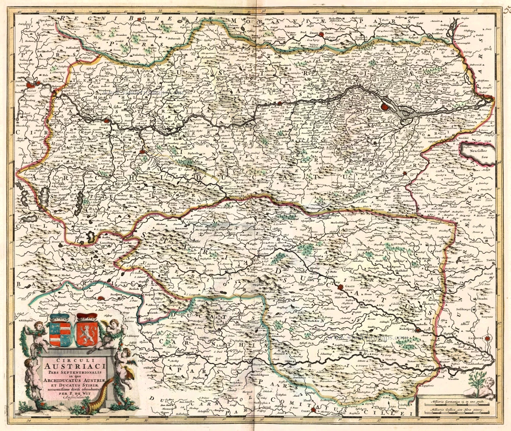
Antique map of Linz by Braun and Hogenberg 1596
The item displayed on this page has been sold. However, we have a similar map in stock:
Linz, by Georg Braun and Frans Hogenberg. 1596
Linsum Austriae vulgo Lintz
[Item number: 23391]

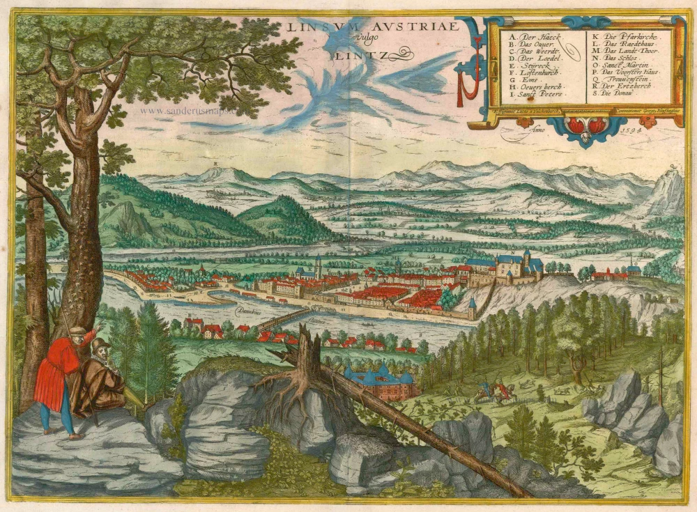


CAPTION: Linsum Austriae, in the vernacular Linz. Signed and dated top right: Depicted by Lukas van Valckenborch, procured by Georg Hoefnagel. In the year 1594. COMMENTARY BY BRAUN (on the verso): "It is indeed impossible to say how many terrible fires have ravaged the city in the past and in more recent times. The first occasion was 1451, just at Eastertide, when it went up almost entirely in flames. Only a short while later, in 1459, when the city had risen but a little from the ashes, a raging blaze destroyed not only private and public buildings but also the bell tower belonging to the main church. This fire was particularly terrifying because it broke out at night. And then in 1542, at the very time when King Ferdinand was staying in the castle with his most beloved wife, part of the city was destroyed for a third time by a large and devastating fire. Thanks to the extraordinary generosity and paternal care of this king, however, Linz was restored to its former glory within a short time." Presented in a perspective framework from the northwest, the view of Hagan castle - here almost hidden by roots and brambles - and the River Danube, on the far side of which appears Linz. Dominating the city from the top of a hill on the right is the imperial palace (N), which arose from 1477 out of a 9th-century fortress and served Emperor Frederick III and his son Maximilian I as an imperial residence. The parish church of the Assumption of the Virgin (K) rises prominently on the left. In the centre stands the Landhaus (M), begun in 1568, whose tower was further heightened on several occasions. The Landhaus formed the focus of Linz's economic and cultural life and from 1574 onwards housed the Protestant estates school, whose teaching staff included Johannes Kepler. Running across the background are the Alpine foothills between Erzberg (R) and Traunstein (Q). (Taschen)
Braun G. & Hogenberg F. and the Civitates Orbis Terrarum.
The Civitates Orbis Terrarum, also known as the 'Braun & Hogenberg', is a six-volume town atlas and the most excellent book of town views and plans ever published: 363 engravings, sometimes beautifully coloured. It was one of the best-selling works in the last quarter of the 16th century. Georg Braun, a skilled writer, wrote the text accompanying the plans and views on the verso. Many plates were engraved after the original drawings of a professional artist, Joris Hoefnagel (1542-1600). The first volume was published in Latin in 1572 and the sixth in 1617. Frans Hogenberg, a talented engraver, created the tables for volumes I through IV, and Simon van den Neuwel made those for volumes V and VI. Other contributors were cartographers Daniel Freese and Heinrich Rantzau, who provided valuable geographical information. Works by Jacob van Deventer, Sebastian Münster, and Johannes Stumpf were also used as references. Translations appeared in German and French, making the atlas accessible to a broader audience.
Since its original publication of volume 1 in 1572, the Civitates Orbis Terrarum has left an indelible mark on the history of cartography. Seven more editions followed the first volume in 1575, 1577, 1582, 1588, 1593, 1599, and 1612. Vol.2, initially released in 1575, saw subsequent editions in 1597 and 1612. The subsequent volumes, each a treasure trove of historical insights, graced the world in 1581, 1588, 1593, 1599, and 1606. The German translation of the first volume, a testament to its widespread appeal, debuted in 1574, followed by the French edition in 1575.
Several printers were involved: Theodor Graminaeus, Heinrich von Aich, Gottfried von Kempen, Johannis Sinniger, Bertram Buchholtz, and Peter von Brachel, all of whom worked in Cologne.
Georg Braun (1541-1622)
Georg Braun, the author of the text accompanying the plans and views in the Civitates Orbis Terrarum, was born in Cologne in 1541. After his studies in Cologne, he entered the Jesuit Order as a novice, indicating his commitment to learning and intellectual pursuits. In 1561, he obtained his bachelor's degree; in 1562, he received his Magister Artium, further demonstrating his academic achievements. Although he left the Jesuit Order, he continued his studies in theology, gaining a licentiate in theology. His theological background likely influenced the content and tone of the text in the Civitates Orbis Terrarum, adding a unique perspective to the work.
Frans Hogenberg (1535-1590)
Frans Hogenberg was a Flemish and German painter, engraver, and mapmaker. He was born in Mechelen as the son of Nicolaas Hogenberg.
By the end of the 1560s, Frans Hogenberg was employed upon Abraham Ortelius's Theatrum Orbis Terrarum, published in 1570; he is named an engraver of numerous maps. In 1568, he was banned from Antwerp by the Duke of Alva and travelled to London, where he stayed a few years before emigrating to Cologne. He immediately embarked on his two most important works, the Civitates, published in 1572 and the Geschichtsblätter, which appeared in several series from 1569 until about 1587.
Thanks to large-scale projects like the Geschichtsblätter and the Civitates, Hogenberg's social circumstances improved with each passing year. He died as a wealthy man in Cologne in 1590.
Linsum Austriae vulgo Lintz
Item Number: 22104 Authenticity Guarantee
Category: Antique maps > Europe > Austria
Antique map - bird's-eye view of Linz by Braun and Hogenberg, with key to locations.
CAPTION: Linsum Austriae, in the vernacular Linz.
Signed and dated top right: Depicted by Lukas van Valckenborch, procured by Georg Hoefnagel. In the year 1594.
COMMENTARY BY BRAUN (on the verso): "It is indeed impossible to say how many terrible fires have ravaged the city in the past and in more recent times. The first occasion was 1451, just at Eastertide, when it went up almost entirely in flames. Only a short while later, in 1459, when the city had risen but a little from the ashes, a raging blaze destroyed not only private and public buildings but also the bell tower belonging to the main church. This fire was particularly terrifying because it broke out at night. And then in 1542, at the very time when King Ferdinand was staying in the castle with his most beloved wife, part of the city was destroyed for a third time by a large and devastating fire. Thanks to the extraordinary generosity and paternal care of this king, however, Linz was restored to its former glory within a short time."
Presented in a perspective framework from the northwest, the view of Hagan castle - here almost hidden by roots and brambles - and the River Danube, on the far side of which appears Linz. Dominating the city from the top of a hill on the right is the imperial palace (N), which arose from 1477 out of a 9th-century fortress and served Emperor Frederick III and his son Maximilian I as an imperial residence. The parish church of the Assumption of the Virgin (K) rises prominently on the left. In the centre stands the Landhaus (M), begun in 1568, whose tower was further heightened on several occasions. The Landhaus formed the focus of Linz's economic and cultural life and from 1574 onwards housed the Protestant estates school, whose teaching staff included Johannes Kepler. Running across the background are the Alpine foothills between Erzberg (R) and Traunstein (Q). (Taschen)
Date of the first edition: 1596
Date of this map: 1596
Date on map: 1594
Copper engraving
Size: 34 x 49cm (13.3 x 19.1 inches)
Verso text: Latin
Condition: Old coloured, excellent.
Condition Rating: A
References: Van der Krogt 4, 2390, State 1; Taschen, Braun and Hogenberg, p.412.
From: Urbium Praecipuarum Mundi Theatrum Quintum Auctore Georgio Braunio Agrippinate. Part 5. Köln, 1596/97. (Van der Krogt 4, 41:1.5)
CAPTION: Linsum Austriae, in the vernacular Linz. Signed and dated top right: Depicted by Lukas van Valckenborch, procured by Georg Hoefnagel. In the year 1594. COMMENTARY BY BRAUN (on the verso): "It is indeed impossible to say how many terrible fires have ravaged the city in the past and in more recent times. The first occasion was 1451, just at Eastertide, when it went up almost entirely in flames. Only a short while later, in 1459, when the city had risen but a little from the ashes, a raging blaze destroyed not only private and public buildings but also the bell tower belonging to the main church. This fire was particularly terrifying because it broke out at night. And then in 1542, at the very time when King Ferdinand was staying in the castle with his most beloved wife, part of the city was destroyed for a third time by a large and devastating fire. Thanks to the extraordinary generosity and paternal care of this king, however, Linz was restored to its former glory within a short time." Presented in a perspective framework from the northwest, the view of Hagan castle - here almost hidden by roots and brambles - and the River Danube, on the far side of which appears Linz. Dominating the city from the top of a hill on the right is the imperial palace (N), which arose from 1477 out of a 9th-century fortress and served Emperor Frederick III and his son Maximilian I as an imperial residence. The parish church of the Assumption of the Virgin (K) rises prominently on the left. In the centre stands the Landhaus (M), begun in 1568, whose tower was further heightened on several occasions. The Landhaus formed the focus of Linz's economic and cultural life and from 1574 onwards housed the Protestant estates school, whose teaching staff included Johannes Kepler. Running across the background are the Alpine foothills between Erzberg (R) and Traunstein (Q). (Taschen)
Braun G. & Hogenberg F. and the Civitates Orbis Terrarum.
The Civitates Orbis Terrarum, also known as the 'Braun & Hogenberg', is a six-volume town atlas and the most excellent book of town views and plans ever published: 363 engravings, sometimes beautifully coloured. It was one of the best-selling works in the last quarter of the 16th century. Georg Braun, a skilled writer, wrote the text accompanying the plans and views on the verso. Many plates were engraved after the original drawings of a professional artist, Joris Hoefnagel (1542-1600). The first volume was published in Latin in 1572 and the sixth in 1617. Frans Hogenberg, a talented engraver, created the tables for volumes I through IV, and Simon van den Neuwel made those for volumes V and VI. Other contributors were cartographers Daniel Freese and Heinrich Rantzau, who provided valuable geographical information. Works by Jacob van Deventer, Sebastian Münster, and Johannes Stumpf were also used as references. Translations appeared in German and French, making the atlas accessible to a broader audience.
Since its original publication of volume 1 in 1572, the Civitates Orbis Terrarum has left an indelible mark on the history of cartography. Seven more editions followed the first volume in 1575, 1577, 1582, 1588, 1593, 1599, and 1612. Vol.2, initially released in 1575, saw subsequent editions in 1597 and 1612. The subsequent volumes, each a treasure trove of historical insights, graced the world in 1581, 1588, 1593, 1599, and 1606. The German translation of the first volume, a testament to its widespread appeal, debuted in 1574, followed by the French edition in 1575.
Several printers were involved: Theodor Graminaeus, Heinrich von Aich, Gottfried von Kempen, Johannis Sinniger, Bertram Buchholtz, and Peter von Brachel, all of whom worked in Cologne.
Georg Braun (1541-1622)
Georg Braun, the author of the text accompanying the plans and views in the Civitates Orbis Terrarum, was born in Cologne in 1541. After his studies in Cologne, he entered the Jesuit Order as a novice, indicating his commitment to learning and intellectual pursuits. In 1561, he obtained his bachelor's degree; in 1562, he received his Magister Artium, further demonstrating his academic achievements. Although he left the Jesuit Order, he continued his studies in theology, gaining a licentiate in theology. His theological background likely influenced the content and tone of the text in the Civitates Orbis Terrarum, adding a unique perspective to the work.
Frans Hogenberg (1535-1590)
Frans Hogenberg was a Flemish and German painter, engraver, and mapmaker. He was born in Mechelen as the son of Nicolaas Hogenberg.
By the end of the 1560s, Frans Hogenberg was employed upon Abraham Ortelius's Theatrum Orbis Terrarum, published in 1570; he is named an engraver of numerous maps. In 1568, he was banned from Antwerp by the Duke of Alva and travelled to London, where he stayed a few years before emigrating to Cologne. He immediately embarked on his two most important works, the Civitates, published in 1572 and the Geschichtsblätter, which appeared in several series from 1569 until about 1587.
Thanks to large-scale projects like the Geschichtsblätter and the Civitates, Hogenberg's social circumstances improved with each passing year. He died as a wealthy man in Cologne in 1590.