
Gmunden by Georg Braun & Frans Hogenberg. c. 1610
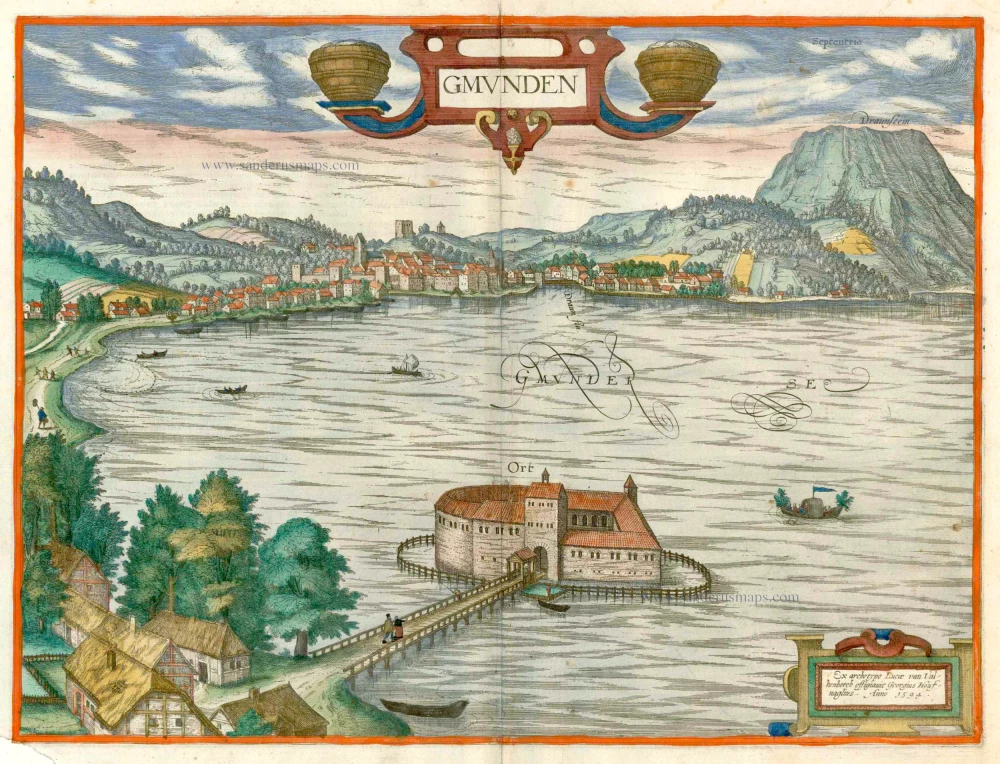


COMMENTARY BY BRAUN (on verso): "Gmunden is a small town in the upper Archduchy of Austria, charmingly situated on a lake, where the Traun has its source. In Gmunden, a very profitable trade is conducted in salt, mined from the surrounding mountains, packed into barrels and exported via the Traun and sold to great profit. For this, they use small, long and narrow boats, which they roof over very skilfully with straw, so that the salt is not damaged by the rain. It is not possible to use bigger boats because of the rocks and trees posing obstacles in the Traun, which is also altogether very narrow."
Gmunden, which lies at the foot of Traunstein Mountain in the Austrian Salzkammergut region, is seen in cavalier perspective from the west shore of Lake Traunsee. Rising towards the rear of the town, which is somewhat schematic, is the Gothic parish church, with further right the Gugelberg tower on top of Gugelberg hill. The fortress of Ort in the foreground, surrounded by water, was constructed in the lake in the 10th century. Gmunden's advantageous location beside the outflow of the River Traun from Lake Traunsee meant that by the 11th century, it was already an important point of salt transhipment. In the 13th century, a turnpike was installed, and the town fortified. Gmunden continued to gain in importance and wealth into the 15th century and was the frequent residence of Emperor Frederick III and Maximilian I. (Taschen)
Braun G. & Hogenberg F. and the Civitates Orbis Terrarum.
The Civitates Orbis Terrarum, also known as the 'Braun & Hogenberg', is a six-volume town atlas and the most excellent book of town views and plans ever published: 363 engravings, sometimes beautifully coloured. It was one of the best-selling works in the last quarter of the 16th century. Georg Braun, a skilled writer, wrote the text accompanying the plans and views on the verso. Many plates were engraved after the original drawings of a professional artist, Joris Hoefnagel (1542-1600). The first volume was published in Latin in 1572 and the sixth in 1617. Frans Hogenberg, a talented engraver, created the tables for volumes I through IV, and Simon van den Neuwel made those for volumes V and VI. Other contributors were cartographers Daniel Freese and Heinrich Rantzau, who provided valuable geographical information. Works by Jacob van Deventer, Sebastian Münster, and Johannes Stumpf were also used as references. Translations appeared in German and French, making the atlas accessible to a wider audience.
Since its original publication of volume 1 in 1572, the Civitates Orbis Terrarum has left an indelible mark on the history of cartography. The first volume was followed by seven more editions in 1575, 1577, 1582, 1588, 1593, 1599, and 1612. Vol.2, initially released in 1575, saw subsequent editions in 1597 and 1612. The subsequent volumes, each a treasure trove of historical insights, graced the world in 1581, 1588, 1593, 1599, and 1606. The German translation of the first volume, a testament to its widespread appeal, debuted in 1574, followed by the French edition in 1575.
Several printers were involved: Theodor Graminaeus, Heinrich von Aich, Gottfried von Kempen, Johannis Sinniger, Bertram Buchholtz, and Peter von Brachel, all of whom worked in Cologne.
Georg Braun (1541-1622)
Georg Braun, the author of the text accompanying the plans and views in the Civitates Orbis Terrarum, was born in Cologne in 1541. After his studies in Cologne, he entered the Jesuit Order as a novice, indicating his commitment to learning and intellectual pursuits. In 1561, he obtained his bachelor's degree; in 1562, he received his Magister Artium, further demonstrating his academic achievements. Although he left the Jesuit Order, he continued his studies in theology, gaining a licentiate in theology. His theological background likely influenced the content and tone of the text in the Civitates Orbis Terrarum, adding a unique perspective to the work.
Frans Hogenberg (1535-1590)
Frans Hogenberg was a Flemish and German painter, engraver, and mapmaker. He was born in Mechelen as the son of Nicolaas Hogenberg.
By the end of the 1560s, Frans Hogenberg was employed upon Abraham Ortelius's Theatrum Orbis Terrarum, published in 1570; he is named an engraver of numerous maps. In 1568, he was banned from Antwerp by the Duke of Alva and travelled to London, where he stayed a few years before emigrating to Cologne. He immediately embarked on his two most important works, the Civitates, published in 1572 and the Geschichtsblätter, which appeared in several series from 1569 until about 1587.
Thanks to large-scale projects like the Geschichtsblätter and the Civitates, Hogenberg's social circumstances improved with each passing year. He died as a wealthy man in Cologne in 1590.
Gmunden.
Item Number: 1819 Authenticity Guarantee
Category: Antique maps > Europe > Austria
Old, antique bird’s-eye view plan of Gmunden by Georg Braun & Frans Hogenberg.
Title: Gmunden.
Ex archetypo Lucae van Valkenborch effigiavit Georgius Houfnaglius. Anno 1594.
Engraver: Georgius Hoefnagel.
Draftsman: Lucas van Valkenborch.
Date of this map: c. 1610.
Date on map: 1594.
Copper engraving, printed on paper.
Map size: 355 x 470mm (13.98 x 18.5 inches).
Sheet size: 410 x 540mm (16.14 x 21.26 inches).
Verso: French text.
Condition: Original coloured, left bottom corner reinstated, not affecting the image.
Condition Rating: A.
From: Théâtre des Principales Villes de tout l'Univers. Tome 5. c. 1610. (Van der Krogt 4, 41:3.5)
COMMENTARY BY BRAUN (on verso): "Gmunden is a small town in the upper Archduchy of Austria, charmingly situated on a lake, where the Traun has its source. In Gmunden, a very profitable trade is conducted in salt, mined from the surrounding mountains, packed into barrels and exported via the Traun and sold to great profit. For this, they use small, long and narrow boats, which they roof over very skilfully with straw, so that the salt is not damaged by the rain. It is not possible to use bigger boats because of the rocks and trees posing obstacles in the Traun, which is also altogether very narrow."
Gmunden, which lies at the foot of Traunstein Mountain in the Austrian Salzkammergut region, is seen in cavalier perspective from the west shore of Lake Traunsee. Rising towards the rear of the town, which is somewhat schematic, is the Gothic parish church, with further right the Gugelberg tower on top of Gugelberg hill. The fortress of Ort in the foreground, surrounded by water, was constructed in the lake in the 10th century. Gmunden's advantageous location beside the outflow of the River Traun from Lake Traunsee meant that by the 11th century, it was already an important point of salt transhipment. In the 13th century, a turnpike was installed, and the town fortified. Gmunden continued to gain in importance and wealth into the 15th century and was the frequent residence of Emperor Frederick III and Maximilian I. (Taschen)
Braun G. & Hogenberg F. and the Civitates Orbis Terrarum.
The Civitates Orbis Terrarum, also known as the 'Braun & Hogenberg', is a six-volume town atlas and the most excellent book of town views and plans ever published: 363 engravings, sometimes beautifully coloured. It was one of the best-selling works in the last quarter of the 16th century. Georg Braun, a skilled writer, wrote the text accompanying the plans and views on the verso. Many plates were engraved after the original drawings of a professional artist, Joris Hoefnagel (1542-1600). The first volume was published in Latin in 1572 and the sixth in 1617. Frans Hogenberg, a talented engraver, created the tables for volumes I through IV, and Simon van den Neuwel made those for volumes V and VI. Other contributors were cartographers Daniel Freese and Heinrich Rantzau, who provided valuable geographical information. Works by Jacob van Deventer, Sebastian Münster, and Johannes Stumpf were also used as references. Translations appeared in German and French, making the atlas accessible to a wider audience.
Since its original publication of volume 1 in 1572, the Civitates Orbis Terrarum has left an indelible mark on the history of cartography. The first volume was followed by seven more editions in 1575, 1577, 1582, 1588, 1593, 1599, and 1612. Vol.2, initially released in 1575, saw subsequent editions in 1597 and 1612. The subsequent volumes, each a treasure trove of historical insights, graced the world in 1581, 1588, 1593, 1599, and 1606. The German translation of the first volume, a testament to its widespread appeal, debuted in 1574, followed by the French edition in 1575.
Several printers were involved: Theodor Graminaeus, Heinrich von Aich, Gottfried von Kempen, Johannis Sinniger, Bertram Buchholtz, and Peter von Brachel, all of whom worked in Cologne.
Georg Braun (1541-1622)
Georg Braun, the author of the text accompanying the plans and views in the Civitates Orbis Terrarum, was born in Cologne in 1541. After his studies in Cologne, he entered the Jesuit Order as a novice, indicating his commitment to learning and intellectual pursuits. In 1561, he obtained his bachelor's degree; in 1562, he received his Magister Artium, further demonstrating his academic achievements. Although he left the Jesuit Order, he continued his studies in theology, gaining a licentiate in theology. His theological background likely influenced the content and tone of the text in the Civitates Orbis Terrarum, adding a unique perspective to the work.
Frans Hogenberg (1535-1590)
Frans Hogenberg was a Flemish and German painter, engraver, and mapmaker. He was born in Mechelen as the son of Nicolaas Hogenberg.
By the end of the 1560s, Frans Hogenberg was employed upon Abraham Ortelius's Theatrum Orbis Terrarum, published in 1570; he is named an engraver of numerous maps. In 1568, he was banned from Antwerp by the Duke of Alva and travelled to London, where he stayed a few years before emigrating to Cologne. He immediately embarked on his two most important works, the Civitates, published in 1572 and the Geschichtsblätter, which appeared in several series from 1569 until about 1587.
Thanks to large-scale projects like the Geschichtsblätter and the Civitates, Hogenberg's social circumstances improved with each passing year. He died as a wealthy man in Cologne in 1590.