Innsbruck by Georg Braun & Frans Hogenberg after Alexander Colyns & Joris Hoefnagel. 1617

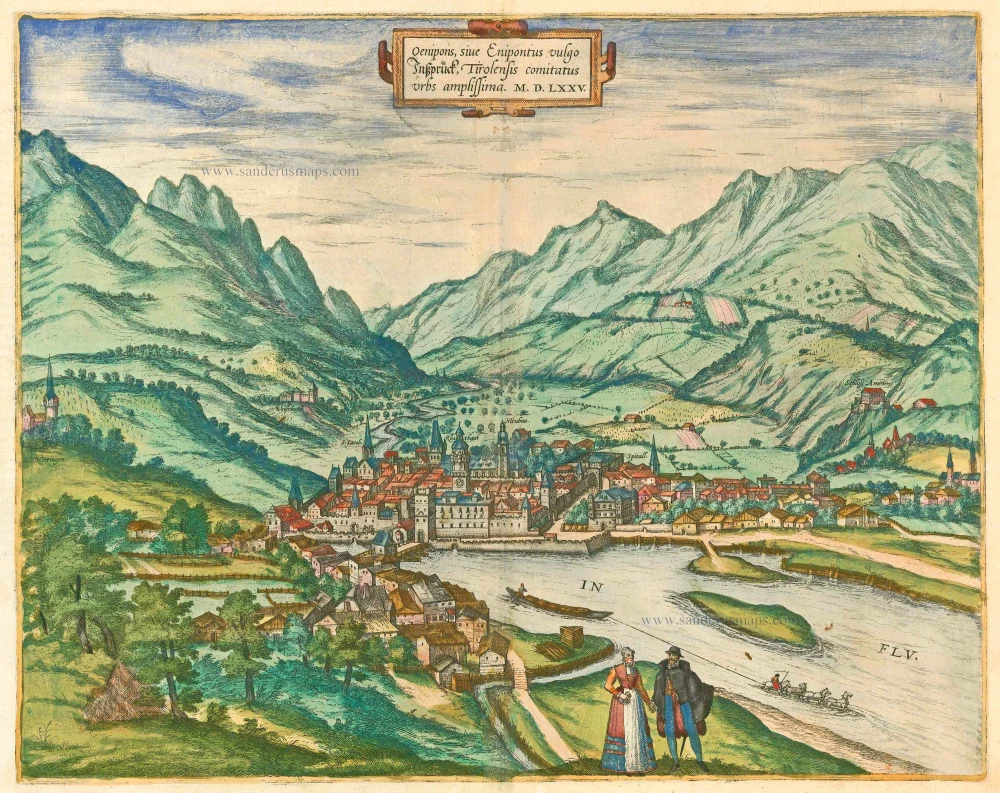
TRANSLATION OF CAPTION TOP: Prospect of the most elegant city of Innsbruck, from the east.
CAPTION LEFT: Ambras castle, built by the Most Serene Archduke Ferdinand of Austria, also contains his library and cabinet of curiosities.
COMMENTARY BY BRAUN (on verso): "Near the city on a hill is Ambras castle, completed by the Most Serene Archduke Ferdinand of Austria, with a magnificent library and study. The prince built this palace for himself and his courtiers so that they could enjoy the cool air there during the summer."
This engraving offers a view of the Inn Valley from the east. In its animation and dynamism, conveyed by the rural staffage, high mountains and dramatic, cloudy sky, the illustration is somewhat untypical of the city atlas. Visible on the left is Ambras castle, in the possession of the Habsburgs from 1363. Below it, on the right, lies the village of Amras, today a suburb of Innsbruck. The castle takes its name from the Latin ad umbras, "in the shade". The medieval complex was remodelled in the Renaissance style by Archduke Ferdinand II, who, in 1563, became governor of the Tyrol. He also founded the magnificent Ambras collections, to which the Amraser Heldenbuch (Ambras Book of Heroes) at that time belonged; this anthology of medieval epics and chivalric tales from the 12th and 13th century was compiled by Hans Ried in 1504-1517 on behalf of Emperor Maximilian I and includes the Song of the Nibelungen and Hartmann von Aue's Erec and Iwein. (Taschen)
Braun G. & Hogenberg F. and the Civitates Orbis Terrarum.
The Civitates Orbis Terrarum, also known as the 'Braun & Hogenberg', is a six-volume town atlas and the most excellent book of town views and plans ever published: 363 engravings, sometimes beautifully coloured. It was one of the best-selling works in the last quarter of the 16th century. Georg Braun, a skilled writer, wrote the text accompanying the plans and views on the verso. Many plates were engraved after the original drawings of a professional artist, Joris Hoefnagel (1542-1600). The first volume was published in Latin in 1572 and the sixth in 1617. Frans Hogenberg, a talented engraver, created the tables for volumes I through IV, and Simon van den Neuwel made those for volumes V and VI. Other contributors were cartographers Daniel Freese and Heinrich Rantzau, who provided valuable geographical information. Works by Jacob van Deventer, Sebastian Münster, and Johannes Stumpf were also used as references. Translations appeared in German and French, making the atlas accessible to a broader audience.
Since its original publication of volume 1 in 1572, the Civitates Orbis Terrarum has left an indelible mark on the history of cartography. Seven more editions followed the first volume in 1575, 1577, 1582, 1588, 1593, 1599, and 1612. Vol.2, initially released in 1575, saw subsequent editions in 1597 and 1612. The subsequent volumes, each a treasure trove of historical insights, graced the world in 1581, 1588, 1593, 1599, and 1606. The German translation of the first volume, a testament to its widespread appeal, debuted in 1574, followed by the French edition in 1575.
Several printers were involved: Theodor Graminaeus, Heinrich von Aich, Gottfried von Kempen, Johannis Sinniger, Bertram Buchholtz, and Peter von Brachel, all of whom worked in Cologne.
Georg Braun (1541-1622)
Georg Braun, the author of the text accompanying the plans and views in the Civitates Orbis Terrarum, was born in Cologne in 1541. After his studies in Cologne, he entered the Jesuit Order as a novice, indicating his commitment to learning and intellectual pursuits. In 1561, he obtained his bachelor's degree; in 1562, he received his Magister Artium, further demonstrating his academic achievements. Although he left the Jesuit Order, he continued his studies in theology, gaining a licentiate in theology. His theological background likely influenced the content and tone of the text in the Civitates Orbis Terrarum, adding a unique perspective to the work.
Frans Hogenberg (1535-1590)
Frans Hogenberg was a Flemish and German painter, engraver, and mapmaker. He was born in Mechelen as the son of Nicolaas Hogenberg.
By the end of the 1560s, Frans Hogenberg was employed upon Abraham Ortelius's Theatrum Orbis Terrarum, published in 1570; he is named an engraver of numerous maps. In 1568, he was banned from Antwerp by the Duke of Alva and travelled to London, where he stayed a few years before emigrating to Cologne. He immediately embarked on his two most important works, the Civitates, published in 1572 and the Geschichtsblätter, which appeared in several series from 1569 until about 1587.
Thanks to large-scale projects like the Geschichtsblätter and the Civitates, Hogenberg's social circumstances improved with each passing year. He died as a wealthy man in Cologne in 1590.
Elegantissimus a Parte Orientali Oenipontis Prospectus.
Item Number: 30108 Authenticity Guarantee
Category: Antique maps > Europe > Austria
Old, antique view of Innsbruck by Georg Braun & Frans Hogenberg, after Alexander Colyns & Joris Hoefnagel.
Title: Elegantissimus a Parte Orientali Oenipontis Prospectus.
Ex archetypo Alexandri Colyns effigiavit Georgius Houfnaglius.
Designer: Alexander Colyns & Joris Hoefnagel.
Date of the first edition: 1596.
Date of this map: 1617.
Copper engraving, printed on paper.
Image size: 360 x 510mm (14.17 x 20.08 inches).
Sheet size: 405 x 530mm (15.94 x 20.87 inches).
Verso: Latin text.
Condition: Excellent.
Condition Rating: A+
From: G. Braun & F. Hogenberg. Civitates Orbis Terrarum. - Urbium Praecipuarum Mundi Theatrum Quintum. Cologne, Petrus von Brachel, 1617. (Van der Krogt 41:1.5 (1617)).
TRANSLATION OF CAPTION TOP: Prospect of the most elegant city of Innsbruck, from the east.
CAPTION LEFT: Ambras castle, built by the Most Serene Archduke Ferdinand of Austria, also contains his library and cabinet of curiosities.
COMMENTARY BY BRAUN (on verso): "Near the city on a hill is Ambras castle, completed by the Most Serene Archduke Ferdinand of Austria, with a magnificent library and study. The prince built this palace for himself and his courtiers so that they could enjoy the cool air there during the summer."
This engraving offers a view of the Inn Valley from the east. In its animation and dynamism, conveyed by the rural staffage, high mountains and dramatic, cloudy sky, the illustration is somewhat untypical of the city atlas. Visible on the left is Ambras castle, in the possession of the Habsburgs from 1363. Below it, on the right, lies the village of Amras, today a suburb of Innsbruck. The castle takes its name from the Latin ad umbras, "in the shade". The medieval complex was remodelled in the Renaissance style by Archduke Ferdinand II, who, in 1563, became governor of the Tyrol. He also founded the magnificent Ambras collections, to which the Amraser Heldenbuch (Ambras Book of Heroes) at that time belonged; this anthology of medieval epics and chivalric tales from the 12th and 13th century was compiled by Hans Ried in 1504-1517 on behalf of Emperor Maximilian I and includes the Song of the Nibelungen and Hartmann von Aue's Erec and Iwein. (Taschen)
Braun G. & Hogenberg F. and the Civitates Orbis Terrarum.
The Civitates Orbis Terrarum, also known as the 'Braun & Hogenberg', is a six-volume town atlas and the most excellent book of town views and plans ever published: 363 engravings, sometimes beautifully coloured. It was one of the best-selling works in the last quarter of the 16th century. Georg Braun, a skilled writer, wrote the text accompanying the plans and views on the verso. Many plates were engraved after the original drawings of a professional artist, Joris Hoefnagel (1542-1600). The first volume was published in Latin in 1572 and the sixth in 1617. Frans Hogenberg, a talented engraver, created the tables for volumes I through IV, and Simon van den Neuwel made those for volumes V and VI. Other contributors were cartographers Daniel Freese and Heinrich Rantzau, who provided valuable geographical information. Works by Jacob van Deventer, Sebastian Münster, and Johannes Stumpf were also used as references. Translations appeared in German and French, making the atlas accessible to a broader audience.
Since its original publication of volume 1 in 1572, the Civitates Orbis Terrarum has left an indelible mark on the history of cartography. Seven more editions followed the first volume in 1575, 1577, 1582, 1588, 1593, 1599, and 1612. Vol.2, initially released in 1575, saw subsequent editions in 1597 and 1612. The subsequent volumes, each a treasure trove of historical insights, graced the world in 1581, 1588, 1593, 1599, and 1606. The German translation of the first volume, a testament to its widespread appeal, debuted in 1574, followed by the French edition in 1575.
Several printers were involved: Theodor Graminaeus, Heinrich von Aich, Gottfried von Kempen, Johannis Sinniger, Bertram Buchholtz, and Peter von Brachel, all of whom worked in Cologne.
Georg Braun (1541-1622)
Georg Braun, the author of the text accompanying the plans and views in the Civitates Orbis Terrarum, was born in Cologne in 1541. After his studies in Cologne, he entered the Jesuit Order as a novice, indicating his commitment to learning and intellectual pursuits. In 1561, he obtained his bachelor's degree; in 1562, he received his Magister Artium, further demonstrating his academic achievements. Although he left the Jesuit Order, he continued his studies in theology, gaining a licentiate in theology. His theological background likely influenced the content and tone of the text in the Civitates Orbis Terrarum, adding a unique perspective to the work.
Frans Hogenberg (1535-1590)
Frans Hogenberg was a Flemish and German painter, engraver, and mapmaker. He was born in Mechelen as the son of Nicolaas Hogenberg.
By the end of the 1560s, Frans Hogenberg was employed upon Abraham Ortelius's Theatrum Orbis Terrarum, published in 1570; he is named an engraver of numerous maps. In 1568, he was banned from Antwerp by the Duke of Alva and travelled to London, where he stayed a few years before emigrating to Cologne. He immediately embarked on his two most important works, the Civitates, published in 1572 and the Geschichtsblätter, which appeared in several series from 1569 until about 1587.
Thanks to large-scale projects like the Geschichtsblätter and the Civitates, Hogenberg's social circumstances improved with each passing year. He died as a wealthy man in Cologne in 1590.