
Rare.
Bruges (Brugge) with the new harbour area after Hendrik la Porte. 1724
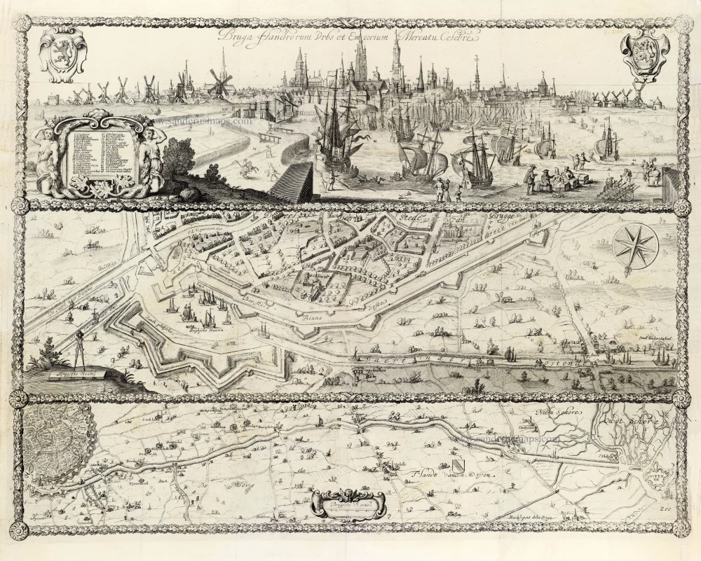
For unclear reasons, this print was once attributed to Cornelis van Caukercken. It was engraved by order of the city magistrate on the arrival of the first freighter in the new harbour area on December 31, 1665. In 1724, it appeared in the Chronijcke van Vlaenderen.
Bruga Flandrorum Urbs et Emporum Mercuta Celebre.
Item Number: 29958 Authenticity Guarantee
Category: Antique maps > Europe > Belgium - Cities
Bruges (Brugge) with the new harbour area after Hendrik la Porte.
Title: Bruga Flandrorum Urbs et Emporum Mercuta Celebre.
Hend. laport delin.
Date of the first edition: 1665.
Date of this map: 1724.
Rare.
This image is divided into three sections:
- The upper part shows a panoramic view of the city. On the left, there is a key to 43 locations.
- The middle part shows a birds-eye view of the new harbour with a part of the town.
- The bottom part shows a map of a part of the town and the canal connecting the new harbour with Ostend.
Copper engraving, printed on paper.
Image size: 435 x 565mm (17.13 x 22.24 inches).
Sheet size: 475 x 575mm (18.7 x 22.64 inches).
Verso: Blank.
Condition: Some fold splits were restored.
Condition Rating: A
From: N. Despars & F. Rommel, Chronijcke van Vlaenderen. Brugge, A. Wydts, 1724. III.
For unclear reasons, this print was once attributed to Cornelis van Caukercken. It was engraved by order of the city magistrate on the arrival of the first freighter in the new harbour area on December 31, 1665. In 1724, it appeared in the Chronijcke van Vlaenderen.
Related items

Brügge. 1726
Brugge by D. Fassmann
[Item number: 5949]

Brugghe. 1656
Brugge by Visscher N. - Schut P.H.
[Item number: 25405]

Brugge. - Carte du Gouvernement de Bruges. - Plan de la Ville de Bruges. ca. 1668
Brugge by Sr. S. de Beaulieu - three plates.
[Item number: 30326]

Affligenium Vulgo Affligem Primaria ac nobilissima in Ducatu Brabantiae, ordinis S. Benedicti Abbatia. 1726
Benedictine Abbey of Affligem, by Antonius Sanderus.
[Item number: 30779]