
Tournai, by Georg Braun and Frans Hogenberg. 1588-97
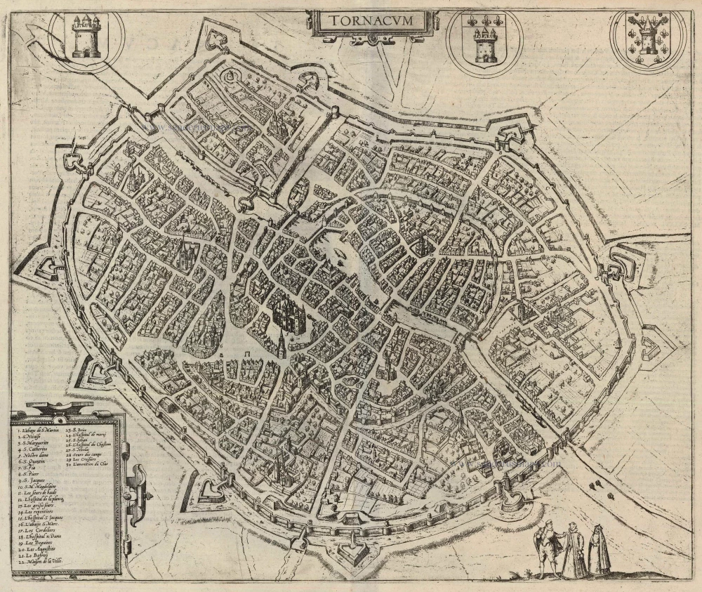
COMMENTARY BY BRAUN: "Tornacum or Turnacum is a city in Gallia Belgica, situated on the Schelde in the territory of the Nervii, called Tournai by its French inhabitants, but Dorneck by the Germans. Tournai has always been a large and powerful city, with abundant goods and commercial activities and wonderfully resourceful craftsmen who invent new articles daily. Although some of these go out of use, they constantly conceive of other new things, both useful and delightful, so that they always have something that provides work and a means of livelihood for the poor."
This is a bird's-eye view from the city's south, fortified with a Renaissance-style moat and wall with projecting bastions. The Old Town wall, dating from 1290, can be seen inside the city. The 12th-century Gothic cathedral of Notre Dame (5) stands out in the centre, Belgium's most important and influential church building. Tournai is one of Belgium's oldest cities. A formidable stronghold as early as the 4th century AD, it was the main centre of the Salian Franks until the mid-5th century. Tournai became an episcopal see at the beginning of the 6th century and belonged then to the Count of Flanders and, from 1188, to France. In the 15th century, the city flourished economically and culturally due to its tapestry industry (Rogier van der Weyden, among others). In the Treaties of Madrid and Cambrai (1526/29), France had to cede Tournai to Charles V, thus becoming part of the Spanish Netherlands. (Taschen)
Braun G. & Hogenberg F. and the Civitates Orbis Terrarum.
The Civitates Orbis Terrarum, also known as the 'Braun & Hogenberg', is a six-volume town atlas and the most excellent book of town views and plans ever published: 363 engravings, sometimes beautifully coloured. It was one of the best-selling works in the last quarter of the 16th century. Georg Braun, a skilled writer, wrote the text accompanying the plans and views on the verso. Many plates were engraved after the original drawings of a professional artist, Joris Hoefnagel (1542-1600). The first volume was published in Latin in 1572 and the sixth in 1617. Frans Hogenberg, a talented engraver, created the tables for volumes I through IV, and Simon van den Neuwel made those for volumes V and VI. Other contributors were cartographers Daniel Freese and Heinrich Rantzau, who provided valuable geographical information. Works by Jacob van Deventer, Sebastian Münster, and Johannes Stumpf were also used as references. Translations appeared in German and French, making the atlas accessible to a broader audience.
Since its original publication of volume 1 in 1572, the Civitates Orbis Terrarum has left an indelible mark on the history of cartography. Seven more editions followed the first volume in 1575, 1577, 1582, 1588, 1593, 1599, and 1612. Vol.2, initially released in 1575, saw subsequent editions in 1597 and 1612. The subsequent volumes, each a treasure trove of historical insights, graced the world in 1581, 1588, 1593, 1599, and 1606. The German translation of the first volume, a testament to its widespread appeal, debuted in 1574, followed by the French edition in 1575.
Several printers were involved: Theodor Graminaeus, Heinrich von Aich, Gottfried von Kempen, Johannis Sinniger, Bertram Buchholtz, and Peter von Brachel, all of whom worked in Cologne.
Georg Braun (1541-1622)
Georg Braun, the author of the text accompanying the plans and views in the Civitates Orbis Terrarum, was born in Cologne in 1541. After his studies in Cologne, he entered the Jesuit Order as a novice, indicating his commitment to learning and intellectual pursuits. In 1561, he obtained his bachelor's degree; in 1562, he received his Magister Artium, further demonstrating his academic achievements. Although he left the Jesuit Order, he continued his studies in theology, gaining a licentiate in theology. His theological background likely influenced the content and tone of the text in the Civitates Orbis Terrarum, adding a unique perspective to the work.
Frans Hogenberg (1535-1590)
Frans Hogenberg was a Flemish and German painter, engraver, and mapmaker. He was born in Mechelen as the son of Nicolaas Hogenberg.
By the end of the 1560s, Frans Hogenberg was employed upon Abraham Ortelius's Theatrum Orbis Terrarum, published in 1570; he is named an engraver of numerous maps. In 1568, he was banned from Antwerp by the Duke of Alva and travelled to London, where he stayed a few years before emigrating to Cologne. He immediately embarked on his two most important works, the Civitates, published in 1572 and the Geschichtsblätter, which appeared in several series from 1569 until about 1587.
Thanks to large-scale projects like the Geschichtsblätter and the Civitates, Hogenberg's social circumstances improved with each passing year. He died as a wealthy man in Cologne in 1590.
Tornacum.
Item Number: 22254 Authenticity Guarantee
Category: Antique maps > Europe > Belgium - Cities
Old, antique bird’s-eye view plan of Tournai, by Georg Braun and Frans Hogenberg.
After Jacob van Deventer. Key to locations.
Title: Tornacum.
Date of the first edition: 1588.
Date of this map: 1588-97.
Copper engraving, printed on paper.
Size (not including margins): 365 x 435mm (14.37 x 17.13 inches).
Verso: Latin text.
Condition: Uncoloured, excellent.
Condition Rating: A+.
From: Liber quartus Urbium Praecipuarum totius Mundi. Cologne, 1588-97. (Koeman, B&H4, Van der Krogt 4, 41:1.4)
COMMENTARY BY BRAUN: "Tornacum or Turnacum is a city in Gallia Belgica, situated on the Schelde in the territory of the Nervii, called Tournai by its French inhabitants, but Dorneck by the Germans. Tournai has always been a large and powerful city, with abundant goods and commercial activities and wonderfully resourceful craftsmen who invent new articles daily. Although some of these go out of use, they constantly conceive of other new things, both useful and delightful, so that they always have something that provides work and a means of livelihood for the poor."
This is a bird's-eye view from the city's south, fortified with a Renaissance-style moat and wall with projecting bastions. The Old Town wall, dating from 1290, can be seen inside the city. The 12th-century Gothic cathedral of Notre Dame (5) stands out in the centre, Belgium's most important and influential church building. Tournai is one of Belgium's oldest cities. A formidable stronghold as early as the 4th century AD, it was the main centre of the Salian Franks until the mid-5th century. Tournai became an episcopal see at the beginning of the 6th century and belonged then to the Count of Flanders and, from 1188, to France. In the 15th century, the city flourished economically and culturally due to its tapestry industry (Rogier van der Weyden, among others). In the Treaties of Madrid and Cambrai (1526/29), France had to cede Tournai to Charles V, thus becoming part of the Spanish Netherlands. (Taschen)
Braun G. & Hogenberg F. and the Civitates Orbis Terrarum.
The Civitates Orbis Terrarum, also known as the 'Braun & Hogenberg', is a six-volume town atlas and the most excellent book of town views and plans ever published: 363 engravings, sometimes beautifully coloured. It was one of the best-selling works in the last quarter of the 16th century. Georg Braun, a skilled writer, wrote the text accompanying the plans and views on the verso. Many plates were engraved after the original drawings of a professional artist, Joris Hoefnagel (1542-1600). The first volume was published in Latin in 1572 and the sixth in 1617. Frans Hogenberg, a talented engraver, created the tables for volumes I through IV, and Simon van den Neuwel made those for volumes V and VI. Other contributors were cartographers Daniel Freese and Heinrich Rantzau, who provided valuable geographical information. Works by Jacob van Deventer, Sebastian Münster, and Johannes Stumpf were also used as references. Translations appeared in German and French, making the atlas accessible to a broader audience.
Since its original publication of volume 1 in 1572, the Civitates Orbis Terrarum has left an indelible mark on the history of cartography. Seven more editions followed the first volume in 1575, 1577, 1582, 1588, 1593, 1599, and 1612. Vol.2, initially released in 1575, saw subsequent editions in 1597 and 1612. The subsequent volumes, each a treasure trove of historical insights, graced the world in 1581, 1588, 1593, 1599, and 1606. The German translation of the first volume, a testament to its widespread appeal, debuted in 1574, followed by the French edition in 1575.
Several printers were involved: Theodor Graminaeus, Heinrich von Aich, Gottfried von Kempen, Johannis Sinniger, Bertram Buchholtz, and Peter von Brachel, all of whom worked in Cologne.
Georg Braun (1541-1622)
Georg Braun, the author of the text accompanying the plans and views in the Civitates Orbis Terrarum, was born in Cologne in 1541. After his studies in Cologne, he entered the Jesuit Order as a novice, indicating his commitment to learning and intellectual pursuits. In 1561, he obtained his bachelor's degree; in 1562, he received his Magister Artium, further demonstrating his academic achievements. Although he left the Jesuit Order, he continued his studies in theology, gaining a licentiate in theology. His theological background likely influenced the content and tone of the text in the Civitates Orbis Terrarum, adding a unique perspective to the work.
Frans Hogenberg (1535-1590)
Frans Hogenberg was a Flemish and German painter, engraver, and mapmaker. He was born in Mechelen as the son of Nicolaas Hogenberg.
By the end of the 1560s, Frans Hogenberg was employed upon Abraham Ortelius's Theatrum Orbis Terrarum, published in 1570; he is named an engraver of numerous maps. In 1568, he was banned from Antwerp by the Duke of Alva and travelled to London, where he stayed a few years before emigrating to Cologne. He immediately embarked on his two most important works, the Civitates, published in 1572 and the Geschichtsblätter, which appeared in several series from 1569 until about 1587.
Thanks to large-scale projects like the Geschichtsblätter and the Civitates, Hogenberg's social circumstances improved with each passing year. He died as a wealthy man in Cologne in 1590.
Related items
Dornick. 1726
Tournai by D. Fassmann
[Item number: 5945]

Doornick 1656
Tournai, by N. Visscher & P.H. Schut.
[Item number: 6996]

Plan de la Ville et Citadelle de Tournay, ... 1712
Tournai by Eugene Fricx.
[Item number: 29560]

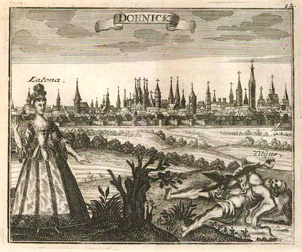
Tournay oder Dornick. 1729
Panoramic view of Tournai by F.B. Werner, published by Fred. Probst.
[Item number: 30668]

Pont des Trous à Tournay. 1823
Pont des Trous, Tournai, lithograph by Dewasme, after L. Haghe.
[Item number: 32801]

Pont à l'Arche à Tournay. 1823
Pont à l'Arche, Tournai, lithograph by Dewasme, after L. Haghe.
[Item number: 32802]

Intérieur des Célestines à Tournay. 1823
Tournai, lithograph by Dewasme, after Prosper de la Barrière.
[Item number: 32816]

Eglise St Brice (Tournay) 1823
Tournai - Eglise St.-Brice, lithograph by Dewasme after Prosper de la Barrière.
[Item number: 32822]

Tornacum. 1612
Tournai by Guicciardini Lodovico
[Item number: 33017]

Cathédrale de Tournay. 1823
Tournai - Cathédrale, Lithograph by Dewasme, after Prosper de la Barrière.
[Item number: 33049]