
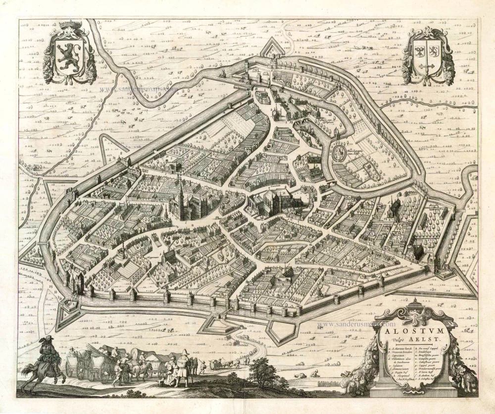
Aalst by Braun & Hogenberg. 1588

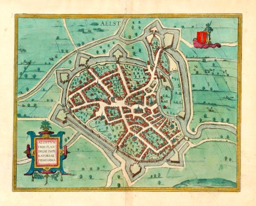
TRANSLATION OF CARTOUCHE TEXT: Aalst, a powerful city in Imperial Flanders.
COMMENTARY BY BRAUN: "Flanders is today divided into three main parts, namely German, French and Imperial Flanders, the latter being so called because it was formerly subject to the German Empire and under its protection. But this part is also called the County of Aalst, from a town of the same name, large, handsome, heavily fortified, and located at a favourable place on the Dender [...]. This town carries out many commercial activities, but especially it has its trade with hops, a well-known flower that is needed for brewing beer, with which the people of Aalst earn no small income."
This bird's-eye view from the south shows the town's fortifications, which were modernised in 1578. The Gothic church of St Martin is in the middle of the city, and above it to the left is the Grote Markt with the Schepenhuis and Belfort. The castle of Aalst is first recorded in AD 866, and in 1164, the town was granted a municipal charter. From the time Count Baldwin IV of Flanders incorporated the County of Aalst east of the Schelde into his domain, the Counts of Flanders owed allegiance to both the French king and the German emperor. After becoming part of the Burgundian dominion under Philip the Bold, Imperial Flanders came into the possession of the Habsburgs through the marriage of Mary of Burgundy to Maximilian I of Austria and passed to the Spanish line after the abdication of Charles V. (Taschen)
Braun G. & Hogenberg F. and the Civitates Orbis Terrarum.
The Civitates Orbis Terrarum, also known as the 'Braun & Hogenberg', is a six-volume town atlas and the most excellent book of town views and plans ever published: 363 engravings, sometimes beautifully coloured. It was one of the best-selling works in the last quarter of the 16th century. Georg Braun, a skilled writer, wrote the text accompanying the plans and views on the verso. Many plates were engraved after the original drawings of a professional artist, Joris Hoefnagel (1542-1600). The first volume was published in Latin in 1572 and the sixth in 1617. Frans Hogenberg, a talented engraver, created the tables for volumes I through IV, and Simon van den Neuwel made those for volumes V and VI. Other contributors were cartographers Daniel Freese and Heinrich Rantzau, who provided valuable geographical information. Works by Jacob van Deventer, Sebastian Münster, and Johannes Stumpf were also used as references. Translations appeared in German and French, making the atlas accessible to a broader audience.
Since its original publication of volume 1 in 1572, the Civitates Orbis Terrarum has left an indelible mark on the history of cartography. Seven more editions followed the first volume in 1575, 1577, 1582, 1588, 1593, 1599, and 1612. Vol.2, initially released in 1575, saw subsequent editions in 1597 and 1612. The subsequent volumes, each a treasure trove of historical insights, graced the world in 1581, 1588, 1593, 1599, and 1606. The German translation of the first volume, a testament to its widespread appeal, debuted in 1574, followed by the French edition in 1575.
Several printers were involved: Theodor Graminaeus, Heinrich von Aich, Gottfried von Kempen, Johannis Sinniger, Bertram Buchholtz, and Peter von Brachel, all of whom worked in Cologne.
Georg Braun (1541-1622)
Georg Braun, the author of the text accompanying the plans and views in the Civitates Orbis Terrarum, was born in Cologne in 1541. After his studies in Cologne, he entered the Jesuit Order as a novice, indicating his commitment to learning and intellectual pursuits. In 1561, he obtained his bachelor's degree; in 1562, he received his Magister Artium, further demonstrating his academic achievements. Although he left the Jesuit Order, he continued his studies in theology, gaining a licentiate in theology. His theological background likely influenced the content and tone of the text in the Civitates Orbis Terrarum, adding a unique perspective to the work.
Frans Hogenberg (1535-1590)
Frans Hogenberg was a Flemish and German painter, engraver, and mapmaker. He was born in Mechelen as the son of Nicolaas Hogenberg.
By the end of the 1560s, Frans Hogenberg was employed upon Abraham Ortelius's Theatrum Orbis Terrarum, published in 1570; he is named an engraver of numerous maps. In 1568, he was banned from Antwerp by the Duke of Alva and travelled to London, where he stayed a few years before emigrating to Cologne. He immediately embarked on his two most important works, the Civitates, published in 1572 and the Geschichtsblätter, which appeared in several series from 1569 until about 1587.
Thanks to large-scale projects like the Geschichtsblätter and the Civitates, Hogenberg's social circumstances improved with each passing year. He died as a wealthy man in Cologne in 1590.
Alostum, Urbs Flandriae Imperatoriae Firmissima.
Item Number: 25358 Authenticity Guarantee
Category: Antique maps > Europe > Belgium - Cities
Antique map - bird's-eye view plan of Aalst by Braun and Hogenberg.
Date of the first edition: 1588
Date of this map: 1588
Copper engraving
Size (not including margins): 34 x 47.5cm (13.3 x 18.5 inches)
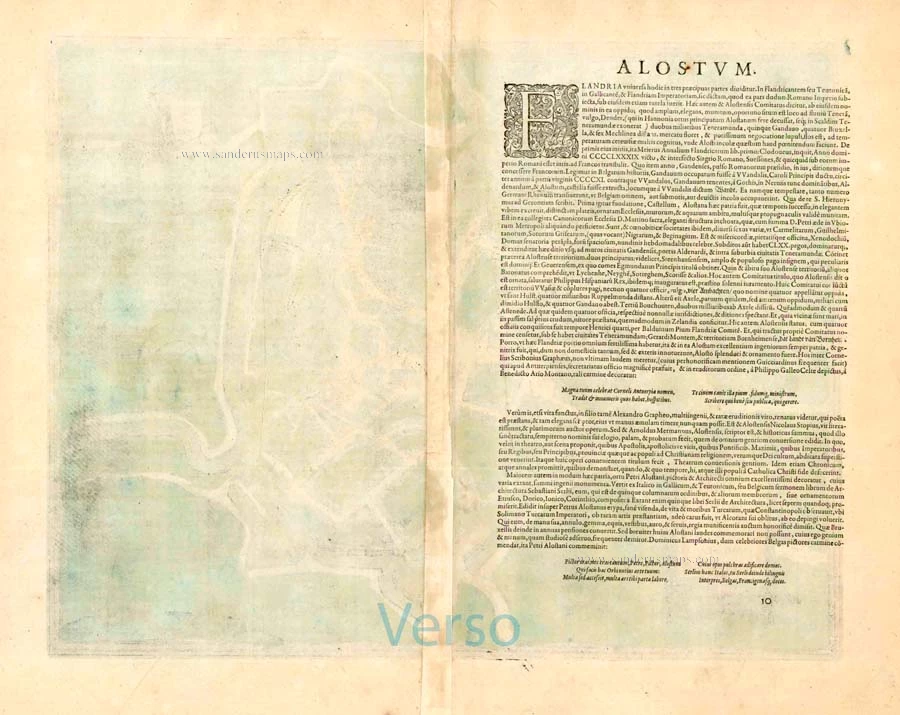
Verso text: Latin
Condition: Old coloured, excellent.
Condition Rating: A+
References: Van der Krogt 4, 9, State 1; Fauser, 23; Taschen, Braun and Hogenberg, p.282.
From: Liber Quartus Urbium Praecipuarum Totius Mundi. Cologne, 1588. (Koeman, B&H4, Van der Krogt 4, 41:1.4)
TRANSLATION OF CARTOUCHE TEXT: Aalst, a powerful city in Imperial Flanders.
COMMENTARY BY BRAUN: "Flanders is today divided into three main parts, namely German, French and Imperial Flanders, the latter being so called because it was formerly subject to the German Empire and under its protection. But this part is also called the County of Aalst, from a town of the same name, large, handsome, heavily fortified, and located at a favourable place on the Dender [...]. This town carries out many commercial activities, but especially it has its trade with hops, a well-known flower that is needed for brewing beer, with which the people of Aalst earn no small income."
This bird's-eye view from the south shows the town's fortifications, which were modernised in 1578. The Gothic church of St Martin is in the middle of the city, and above it to the left is the Grote Markt with the Schepenhuis and Belfort. The castle of Aalst is first recorded in AD 866, and in 1164, the town was granted a municipal charter. From the time Count Baldwin IV of Flanders incorporated the County of Aalst east of the Schelde into his domain, the Counts of Flanders owed allegiance to both the French king and the German emperor. After becoming part of the Burgundian dominion under Philip the Bold, Imperial Flanders came into the possession of the Habsburgs through the marriage of Mary of Burgundy to Maximilian I of Austria and passed to the Spanish line after the abdication of Charles V. (Taschen)
Braun G. & Hogenberg F. and the Civitates Orbis Terrarum.
The Civitates Orbis Terrarum, also known as the 'Braun & Hogenberg', is a six-volume town atlas and the most excellent book of town views and plans ever published: 363 engravings, sometimes beautifully coloured. It was one of the best-selling works in the last quarter of the 16th century. Georg Braun, a skilled writer, wrote the text accompanying the plans and views on the verso. Many plates were engraved after the original drawings of a professional artist, Joris Hoefnagel (1542-1600). The first volume was published in Latin in 1572 and the sixth in 1617. Frans Hogenberg, a talented engraver, created the tables for volumes I through IV, and Simon van den Neuwel made those for volumes V and VI. Other contributors were cartographers Daniel Freese and Heinrich Rantzau, who provided valuable geographical information. Works by Jacob van Deventer, Sebastian Münster, and Johannes Stumpf were also used as references. Translations appeared in German and French, making the atlas accessible to a broader audience.
Since its original publication of volume 1 in 1572, the Civitates Orbis Terrarum has left an indelible mark on the history of cartography. Seven more editions followed the first volume in 1575, 1577, 1582, 1588, 1593, 1599, and 1612. Vol.2, initially released in 1575, saw subsequent editions in 1597 and 1612. The subsequent volumes, each a treasure trove of historical insights, graced the world in 1581, 1588, 1593, 1599, and 1606. The German translation of the first volume, a testament to its widespread appeal, debuted in 1574, followed by the French edition in 1575.
Several printers were involved: Theodor Graminaeus, Heinrich von Aich, Gottfried von Kempen, Johannis Sinniger, Bertram Buchholtz, and Peter von Brachel, all of whom worked in Cologne.
Georg Braun (1541-1622)
Georg Braun, the author of the text accompanying the plans and views in the Civitates Orbis Terrarum, was born in Cologne in 1541. After his studies in Cologne, he entered the Jesuit Order as a novice, indicating his commitment to learning and intellectual pursuits. In 1561, he obtained his bachelor's degree; in 1562, he received his Magister Artium, further demonstrating his academic achievements. Although he left the Jesuit Order, he continued his studies in theology, gaining a licentiate in theology. His theological background likely influenced the content and tone of the text in the Civitates Orbis Terrarum, adding a unique perspective to the work.
Frans Hogenberg (1535-1590)
Frans Hogenberg was a Flemish and German painter, engraver, and mapmaker. He was born in Mechelen as the son of Nicolaas Hogenberg.
By the end of the 1560s, Frans Hogenberg was employed upon Abraham Ortelius's Theatrum Orbis Terrarum, published in 1570; he is named an engraver of numerous maps. In 1568, he was banned from Antwerp by the Duke of Alva and travelled to London, where he stayed a few years before emigrating to Cologne. He immediately embarked on his two most important works, the Civitates, published in 1572 and the Geschichtsblätter, which appeared in several series from 1569 until about 1587.
Thanks to large-scale projects like the Geschichtsblätter and the Civitates, Hogenberg's social circumstances improved with each passing year. He died as a wealthy man in Cologne in 1590.
Related items

Aelst. 1659
Aalst by Matthäus Merian and sons.
[Item number: 2114]
Alostum Vulgo Aalst. 1644
Aalst, by A. Sanderus.
[Item number: 25271]

Aelst 1612
Aalst by Lodovico Guicciardini.
[Item number: 30794]

Nova et accurata Comitatus et ditionis Alostanae 1644 (= first edition)
Aalst (Graafschap en Kasselrij) - Melle - Balegem, door Antonius Sanderus
[Item number: 32986]

Ecclesia Collegiata Sti Martini, Alosti. 1644 (= first edition)
Aalst - St.-Maartenskerk, door Antonius Sanderus
[Item number: 32987]