
Huy, by Georg Braun and Frans Hogenberg. 1597

TRANSLATION OF CARTOUCHE TEXT LEFT: Huum, capital of the Condrusi in Belgian Gaul, of which this plate, drawn true to nature and very exactly in order to embellish this topographical work, was provided by a most erudite gentleman, R. D. Remaclus of Limbourg, renowned in the art of medicine, and D. Paulus, among the canons of Liège an important patron and sponsor of students.
COMMENTARY BY BRAUN: "Huy is an old and elegant city in German-Brabant, situated on the Meuse in a wooded valley between the mountains. This town has large, beautiful and old buildings. In them live very many excellent nobles, who possess houses that are wonderfully decorated, both inside and out. Several of them have splendid battlements and towers, as if they were royal castles."
The view shows the city of Huy from the northeast. The Gothic collegiate church of Notre-Dame, which stands out in the middle of the plate (2), was begun in 1311 and completed in 1536; the 11th-century crypt is still preserved. The castle has been the landmark of this town since the 15th century. Here it still appears as a filigree château, but from 1817 it was converted into a citadel. Huy boasts the oldest municipal charter on the European continent, for a document signed by Prince-Bishop Theoduin confirms the granting of a charter in 1066. The city was a centre of the clothing industry in the 13th and 14th centuries, and exported its products to places as far off as Russia and Scandinavia.
Braun G. & Hogenberg F. and the Civitates Orbis Terrarum.
The Civitates Orbis Terrarum, also known as the 'Braun & Hogenberg', is a six-volume town atlas and the most excellent book of town views and plans ever published: 363 engravings, sometimes beautifully coloured. It was one of the best-selling works in the last quarter of the 16th century. Georg Braun, a skilled writer, wrote the text accompanying the plans and views on the verso. Many plates were engraved after the original drawings of a professional artist, Joris Hoefnagel (1542-1600). The first volume was published in Latin in 1572 and the sixth in 1617. Frans Hogenberg, a talented engraver, created the tables for volumes I through IV, and Simon van den Neuwel made those for volumes V and VI. Other contributors were cartographers Daniel Freese and Heinrich Rantzau, who provided valuable geographical information. Works by Jacob van Deventer, Sebastian Münster, and Johannes Stumpf were also used as references. Translations appeared in German and French, making the atlas accessible to a broader audience.
Since its original publication of volume 1 in 1572, the Civitates Orbis Terrarum has left an indelible mark on the history of cartography. Seven more editions followed the first volume in 1575, 1577, 1582, 1588, 1593, 1599, and 1612. Vol.2, initially released in 1575, saw subsequent editions in 1597 and 1612. The subsequent volumes, each a treasure trove of historical insights, graced the world in 1581, 1588, 1593, 1599, and 1606. The German translation of the first volume, a testament to its widespread appeal, debuted in 1574, followed by the French edition in 1575.
Several printers were involved: Theodor Graminaeus, Heinrich von Aich, Gottfried von Kempen, Johannis Sinniger, Bertram Buchholtz, and Peter von Brachel, all of whom worked in Cologne.
Georg Braun (1541-1622)
Georg Braun, the author of the text accompanying the plans and views in the Civitates Orbis Terrarum, was born in Cologne in 1541. After his studies in Cologne, he entered the Jesuit Order as a novice, indicating his commitment to learning and intellectual pursuits. In 1561, he obtained his bachelor's degree; in 1562, he received his Magister Artium, further demonstrating his academic achievements. Although he left the Jesuit Order, he continued his studies in theology, gaining a licentiate in theology. His theological background likely influenced the content and tone of the text in the Civitates Orbis Terrarum, adding a unique perspective to the work.
Frans Hogenberg (1535-1590)
Frans Hogenberg was a Flemish and German painter, engraver, and mapmaker. He was born in Mechelen as the son of Nicolaas Hogenberg.
By the end of the 1560s, Frans Hogenberg was employed upon Abraham Ortelius's Theatrum Orbis Terrarum, published in 1570; he is named an engraver of numerous maps. In 1568, he was banned from Antwerp by the Duke of Alva and travelled to London, where he stayed a few years before emigrating to Cologne. He immediately embarked on his two most important works, the Civitates, published in 1572 and the Geschichtsblätter, which appeared in several series from 1569 until about 1587.
Thanks to large-scale projects like the Geschichtsblätter and the Civitates, Hogenberg's social circumstances improved with each passing year. He died as a wealthy man in Cologne in 1590.
Huum Opp. Condrusorum Caput ...
Item Number: 23973 Authenticity Guarantee
Category: Antique maps > Europe > Belgium - Cities
Old map - bird's-eye view of Huy by Braun and Hogenberg, with key to locations. .
Date of the first edition: 1575
Date of this map: 1597
Copper engraving
Size: 30 x 46.5cm (11.7 x 18.1 inches)
Verso text: Latin
Condition: Uncoloured, excellent.
Condition Rating: A
References: Van der Krogt 4, 1854; Taschen, Braun and Hogenberg, p.148.
From: Civitates Orbis Terrarum, ... Part 2: De Praecipuis, Totius Universi Urbibus, Liber Secundus. Köln, Bertram Buchholz, 1597. (Van der Krogt 4, 41:1.2)
TRANSLATION OF CARTOUCHE TEXT LEFT: Huum, capital of the Condrusi in Belgian Gaul, of which this plate, drawn true to nature and very exactly in order to embellish this topographical work, was provided by a most erudite gentleman, R. D. Remaclus of Limbourg, renowned in the art of medicine, and D. Paulus, among the canons of Liège an important patron and sponsor of students.
COMMENTARY BY BRAUN: "Huy is an old and elegant city in German-Brabant, situated on the Meuse in a wooded valley between the mountains. This town has large, beautiful and old buildings. In them live very many excellent nobles, who possess houses that are wonderfully decorated, both inside and out. Several of them have splendid battlements and towers, as if they were royal castles."
The view shows the city of Huy from the northeast. The Gothic collegiate church of Notre-Dame, which stands out in the middle of the plate (2), was begun in 1311 and completed in 1536; the 11th-century crypt is still preserved. The castle has been the landmark of this town since the 15th century. Here it still appears as a filigree château, but from 1817 it was converted into a citadel. Huy boasts the oldest municipal charter on the European continent, for a document signed by Prince-Bishop Theoduin confirms the granting of a charter in 1066. The city was a centre of the clothing industry in the 13th and 14th centuries, and exported its products to places as far off as Russia and Scandinavia.
Braun G. & Hogenberg F. and the Civitates Orbis Terrarum.
The Civitates Orbis Terrarum, also known as the 'Braun & Hogenberg', is a six-volume town atlas and the most excellent book of town views and plans ever published: 363 engravings, sometimes beautifully coloured. It was one of the best-selling works in the last quarter of the 16th century. Georg Braun, a skilled writer, wrote the text accompanying the plans and views on the verso. Many plates were engraved after the original drawings of a professional artist, Joris Hoefnagel (1542-1600). The first volume was published in Latin in 1572 and the sixth in 1617. Frans Hogenberg, a talented engraver, created the tables for volumes I through IV, and Simon van den Neuwel made those for volumes V and VI. Other contributors were cartographers Daniel Freese and Heinrich Rantzau, who provided valuable geographical information. Works by Jacob van Deventer, Sebastian Münster, and Johannes Stumpf were also used as references. Translations appeared in German and French, making the atlas accessible to a broader audience.
Since its original publication of volume 1 in 1572, the Civitates Orbis Terrarum has left an indelible mark on the history of cartography. Seven more editions followed the first volume in 1575, 1577, 1582, 1588, 1593, 1599, and 1612. Vol.2, initially released in 1575, saw subsequent editions in 1597 and 1612. The subsequent volumes, each a treasure trove of historical insights, graced the world in 1581, 1588, 1593, 1599, and 1606. The German translation of the first volume, a testament to its widespread appeal, debuted in 1574, followed by the French edition in 1575.
Several printers were involved: Theodor Graminaeus, Heinrich von Aich, Gottfried von Kempen, Johannis Sinniger, Bertram Buchholtz, and Peter von Brachel, all of whom worked in Cologne.
Georg Braun (1541-1622)
Georg Braun, the author of the text accompanying the plans and views in the Civitates Orbis Terrarum, was born in Cologne in 1541. After his studies in Cologne, he entered the Jesuit Order as a novice, indicating his commitment to learning and intellectual pursuits. In 1561, he obtained his bachelor's degree; in 1562, he received his Magister Artium, further demonstrating his academic achievements. Although he left the Jesuit Order, he continued his studies in theology, gaining a licentiate in theology. His theological background likely influenced the content and tone of the text in the Civitates Orbis Terrarum, adding a unique perspective to the work.
Frans Hogenberg (1535-1590)
Frans Hogenberg was a Flemish and German painter, engraver, and mapmaker. He was born in Mechelen as the son of Nicolaas Hogenberg.
By the end of the 1560s, Frans Hogenberg was employed upon Abraham Ortelius's Theatrum Orbis Terrarum, published in 1570; he is named an engraver of numerous maps. In 1568, he was banned from Antwerp by the Duke of Alva and travelled to London, where he stayed a few years before emigrating to Cologne. He immediately embarked on his two most important works, the Civitates, published in 1572 and the Geschichtsblätter, which appeared in several series from 1569 until about 1587.
Thanks to large-scale projects like the Geschichtsblätter and the Civitates, Hogenberg's social circumstances improved with each passing year. He died as a wealthy man in Cologne in 1590.
Related items
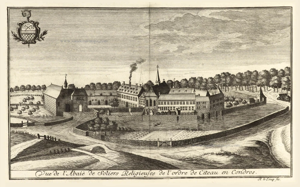
Vue de l'Abaie de Soliers Religieuses de l'Ordre de Citeau en Condros. 1738-44
Huy - Ben-Ahin by Remacle Leloup.
[Item number: 515]
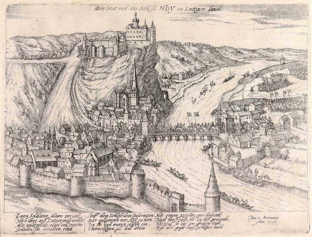
Die Stat und das Schloss Hoy im Luttger Lande. 1595-1612
Huy by Frans Hogenberg.
[Item number: 12565]

Huyum vulgo Huy. 1652
Huy, by Joan Blaeu.
[Item number: 31180]

Porte du Maillet à Huy. 1823
Huy - Porte du Maillet, by Dewasme, after Roloff.
[Item number: 32806]