
Antique map of British Isles by Jacobz Theunis Lootsman 1644
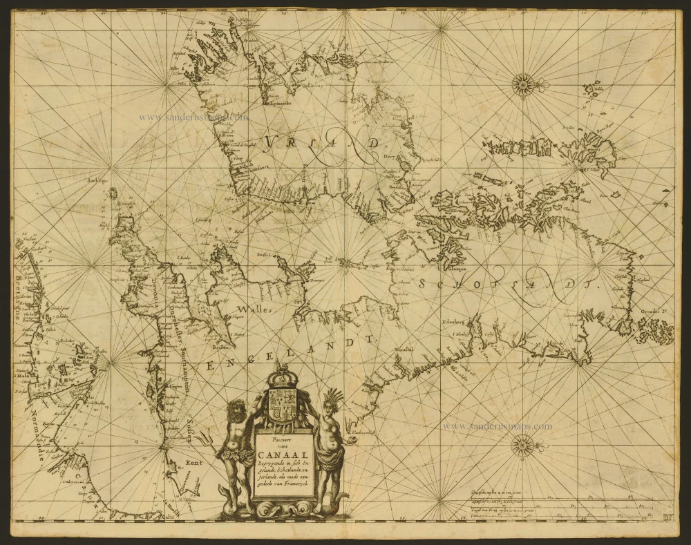
Pascaart vant Canaal Begrypende in sich Engelandt, Schotlandt, en Jerlandt, als mede een gedeelt van Francryck.
Item Number: 6611 Authenticity Guarantee
Category: Antique maps > Europe > British Isles
Copper engraving
Size: 43 x 55cm (17 x 22 inches)
Verso text: Dutch
Condition: Close left margin, upper margin trimmed to neatline, some shine-through of verso text.
References: Shirley (BI to 1650), 545.
From: De Lichtende Columne, Ofte Zee-Spiegel, . . . Amsterdam, Anthony Jacobsz Lootsman, 1644. (Koeman, Jac14)
"The 1644 chart of the British Isles by Anthony Jacobsz, a development of the earlier form pioneered by Jacob Colom, established a format which was to be copied by later marine cartographers. The British Isles are showh sideways in full, oriented so that west is at the top, and the map is criss-crossed by rhumb lines radiating from a number of focal points or compass roses. Coast towns are marked but there are no interior details other than decorative shields carrying national coat of arms. The cartouche is flanked by an ancient British man and woman and surmounted by a decorative crown and coat of arms. Most of the east coast of England is obscured by a cartouche; in some. On the reverse there is half a page of text, detailing the title to the second chapter of the atlas and giving the date.
A feature of geographical interest is the more correct outline given to the western part of Ireland. The distinct shape of Connaught shown on this chart and its later versions was not usually picked up on English maps until after 1685, when the findings of William Petty's surveys were printed.
Jacobsz's sea atlas was reprinted in 1645, 1649, and 1650 with Dutch text. There was an edition in 1649 with English text (some of the chapters being dated as early as 1643) and frequent further editions in both languages throughout the remainder of the century.
Similar sea charts to the Jacobsz prototype were published by Pieter Goos in 1650, by Jan Jansson in the same year, by the English hydrographer Joseph Moxon in 1657 and by others. The Jacobsz family continued marine publishing throughout the rest of the seventeenth century under the surname Loots or Lootsmand, meaning 'Pilot'." (Shirley)