
Northern Scotland - Hebrids and Orkney Islands, by Thomaso Porcacchi. 1590

Thomaso (Tommaso) Porcacchi (1530-1585)
Thomaso Porcacchi was born in Castiglion Fiorentino (Arentino), Tuscany, into a poor family. Through the patronage of Duke Cosimo I de' Medici, he was able to pursue his studies; afterwards, he embarked on a career as a translator, editor and author, initially in Florence, often working with the humanist scholar Lodovico Domenichi. His speciality was classical texts, particularly of a geographical and historical nature. Through this work, he came into contact with the prominent Venetian publisher Gabriel Giolito de' Ferrari and, in 1559, he moved to Venice to form a fruitful association with Giolito, who had produced several books containing maps.
Later in his career, Porcacchi composed an isolario, L'isole piu famose del mondo ..., published by Simone Galignani de Karera and Girolamo Porro in 1572. In 1574 Porro engraved the plates for another Porcachi volume, Funerali antichi di diversi popoli, et nationi ..., and he later contributed the maps to a new edition of Claudius Prolemy's Geographiae universae tum veteris tum novae ..., edited by Giovanni Antonio Magini and published by the Heirs of Simone Galignani de Karera.
The first edition of Porcacchi's L'isole piu famose contained 30 engraved maps, set in text. The coverage was worldwide, albeit concentrated on the Mediterranean. For the second edition, the text was rewritten, and 17 additional maps were inserted, to make a total of 47.
Isole Hebride, et Orcade. - [Above map :] Descrittione dell'Isole Hebridi, et Orcade.
Item Number: 29733 Authenticity Guarantee
Category: Antique maps > Europe > British Isles
Old, antique map of Northern Scotland - Hebrids and Orkney Islands, by Thomaso Porcacchi.
Title: Isole Hebride, et Orcade. - [Above map :] Descrittione dell'Isole Hebridi, et Orcade.
Engraver: Girolamo Porro.
Date of the first edition: 1572.
Date of this map: 1590.
Copper engraving, printed on paper.
Image size: 100 x 140mm (3.94 x 5.51 inches).
Sheet size: 300 x 200mm (11.81 x 7.87 inches).
Verso: Italian text.
Condition: Slightly spotted.
Condition Rating: A.
From: Porcacchi T. L'Isole Piu Famose Del Mondo. Venice, Giorgio Angelieri for the Heirs of Simone Galignani, 1590.
Thomaso (Tommaso) Porcacchi (1530-1585)
Thomaso Porcacchi was born in Castiglion Fiorentino (Arentino), Tuscany, into a poor family. Through the patronage of Duke Cosimo I de' Medici, he was able to pursue his studies; afterwards, he embarked on a career as a translator, editor and author, initially in Florence, often working with the humanist scholar Lodovico Domenichi. His speciality was classical texts, particularly of a geographical and historical nature. Through this work, he came into contact with the prominent Venetian publisher Gabriel Giolito de' Ferrari and, in 1559, he moved to Venice to form a fruitful association with Giolito, who had produced several books containing maps.
Later in his career, Porcacchi composed an isolario, L'isole piu famose del mondo ..., published by Simone Galignani de Karera and Girolamo Porro in 1572. In 1574 Porro engraved the plates for another Porcachi volume, Funerali antichi di diversi popoli, et nationi ..., and he later contributed the maps to a new edition of Claudius Prolemy's Geographiae universae tum veteris tum novae ..., edited by Giovanni Antonio Magini and published by the Heirs of Simone Galignani de Karera.
The first edition of Porcacchi's L'isole piu famose contained 30 engraved maps, set in text. The coverage was worldwide, albeit concentrated on the Mediterranean. For the second edition, the text was rewritten, and 17 additional maps were inserted, to make a total of 47.
Related items
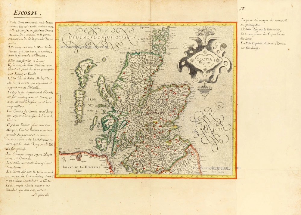
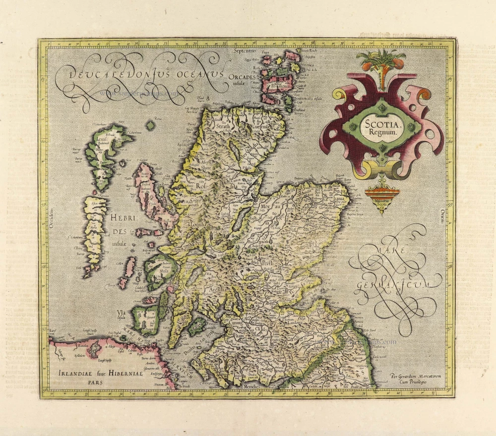
Scotia Regnum. c. 1610-1650
Scotland, by Gerard Mercator.
[Item number: 31015]

Le Royaume d'Escosse Divisé en Parties Septentrionale & Meridionale; Subdivisé en Provinces, Comtez &c. 1692
Scotland by N. Sanson, so-called published by Hubert Jaillot. (Pirated edition by Pierre Mortier).
[Item number: 31173]
Scotia Regnum. 1633
Scotland, by Gerard Mercator.
[Item number: 32180]

Extremely rare Italian Scotland-map
Scotiae nova et accurata descriptio. - Scotia Britannicae Insule pars septentrionalior, ...
Scotland by an Italian mapmaker, derived from a map by A. Lafreri and Bishop Leslie.
[Item number: 33066]
new