
British Isles by Guillaume Delisle, published by Covens & Mortier. 1730

In about 1708, Delisle's general map of the British Isles, first produced in Paris in 1702, was copied by Pierre Mortier for publication in Amsterdam. The plate is slightly smaller, and no engraver or designer's signature appears. Above the top border is an additional Latin title: "Magnae Britanniae Tabula, Comprehendens Angliae, Scotiae, ac Hiberniae Regna, Ad Usum Serenissimi Burgundiae Ducis". The map itself, and the decorative features, are almost identical to those of de L'Isle.
Covens & Mortier. A Map Publishing House in Amsterdam. 1721-1866.
For almost two centuries, the Amsterdam firm of Covens & Mortier was the most significant and crucial Dutch publishing house in commercial cartography. In terms of quantity, it was the biggest contemporary map-trading house worldwide, distributing innumerable maps, atlases, globes, and books.
Pieter (Pierre) Mortier (Leiden, 1661 – Amsterdam, 1711)
Nothing is known about the youth of Pieter Mortier. He studied in Paris from 1681 to approximately 1685. He must have come into contact with French 'libraires' and learned the bookselling trade there. In 1685, he returned to Amsterdam and opened a small bookshop. He joined the Book, Art Sellers' and Printers' Guild the same year.
Pieter sold books in Dutch and foreign languages but also published books himself, usually in French. His business flourished so much that in 1688, he was forced to rent another house on the Vijgendam.
Pieter Mortier's first privilege for maps was granted by the States of Holland and West Friesland on September 15, 1690. It refers to Sanson's maps, which he 'is printing and correcting with great pains and care'.
Pieter began publishing maps and atlases on a large scale. By the beginning of the 18th century, he had become so wealthy that he could purchase three houses in Amsterdam: the Beurssluis, on the Vijgendam, and the Heremietensteeg. He rebuilt the Vijgendam house into a large, prestigious structure that would serve for over a century as a shop, business, and residential structure for Covens & Mortier's publishing house.
He died on February 13, 1711, after a brief illness. The company continued under the management of Pieter's widow, Amelia' s-Gravesande.
After she died in 1719, her son, Cornelis, took over the management for a few years.
On November 20, 1721, a company was founded by Cornelis Mortier and Johannes Covens I. The latter was married the same year to Cornelis's sister. From that year on, the name of :
Covens & Mortier.
Their firm would see a massive expansion in the next 140 years. In 1732, the heirs sold the property to their brother Cornelis and his partner Covens. Their main competitors were Reinier & Josua Ottens and Gerard Valck & Petrus Schenck. After the death of Johannes Covens I (1774), his son Johannes Covens II (1722-1794) entered the business. In 1778, Johannes added a new company name :
J. Covens & Son.
Johannes Covens II was succeeded by his son Cornelis Covens (1764-1825), who, in turn, brought Peter Mortier IV, the great-grandson of Petrus Mortier I, into the business. The name was from 1794 to 1866:
Mortier, Covens & Son.
The last Covens in the series was Cornelis Johannes Covens (1806-1880).
Covens & Mortier had a large stock of atlases and maps, including Delisle, Jaillot, Johannes Janssonius, Sanson, and Claes Jansz. Visscher, Nicolaas Visscher, and Frederik de Wit. For decades, the press produced an impressive number of atlases.
Guillaume Delisle (Paris, 1675 – 1726)
Guillaume Delisle (de L’Isle), one of the key figures in the development of French cartography, is the son of Claude Delisle, a cartographer, and the half-brother of astronomers Joseph-Nicolas Delisle and Louis de l'Isle de la Croyère.
While his father has to be given credit for educating Guillaume, the boy showed early signs of being an exceptional talent. He soon contributed to the family workshop by drawing maps for his father's historical works. To perfect his skills, Guillaume Delisle became the student of the astronomer Jean-Dominique Cassini. Early on, he produced high-quality maps, the first being his Carte de la Nouvelle-France et des Pays Voisins in 1696. Delisle's first atlas appeared around 1700, and in 1702 he became a member of the French Académie Royale des Sciences. He taught geography to the young Louis XV, and in 1718 he received the title of Premier Géographe du Roi. On a commission from Peter the Great, he produced a map of the Caspian Sea, a region barely known. Many of the place names he gave are still in use. His Carte de la Louisiane et du cours du Mississippi (1718) is the first detailed map of this region.
A six-year-long plagiarism trial pits Delisle against Jean-Baptiste Nolin, cartographer. It is Nolin, the real plagiarist, who loses.
Delisle has remained famous for his astronomical-based corrections and the completeness of its topography. The high scientific quality of the work produced by the Delisle family contrasted with the workshop of Sanson. While Sanson knowingly published outdated facts and mistakes, Delisle constantly updated his maps to reflect widening knowledge of the world.
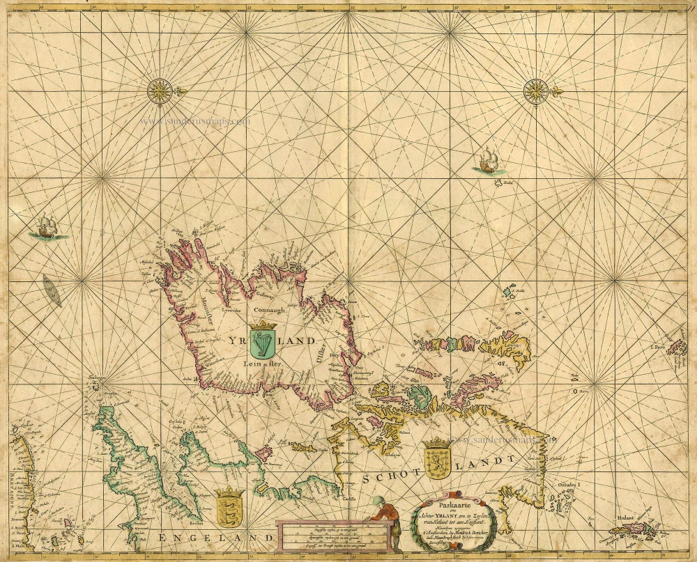
Les Isles Britanniques ou sont le Royaume D'Angleterre Tiré de Sped Celuy D'Ecosse Tiré de Th. Pont et Celuy D'Irlande Riré de Petti.
Item Number: 25680 Authenticity Guarantee
Category: Antique maps > Europe > British Isles
Old, antique map of British Isles, by Guillaume Delisle - Covens & Mortier.
Title: Les Isles Britanniques ou sont le Royaume D'Angleterre Tiré de Sped Celuy D'Ecosse Tiré de Th. Pont et Celuy D'Irlande Riré de Petti.
Cartographer: Guillaume Delisle.
Date of the first edition: c. 1708.
Date of this map: 1730.
Copper engraving, printed on paper.
Size (not including margins): 460 x 575mm (18.11 x 22.64 inches).
Verso: Blank.
Condition: Original coloured in outline, excellent.
Condition Rating: A+.
References: Shirley (BI to 1750), Mortier 1
From: Atlas Nouveau ... Par Guillaume de l'Isle ... Amsterdam, Covens & Mortier, 1730.
In about 1708, Delisle's general map of the British Isles, first produced in Paris in 1702, was copied by Pierre Mortier for publication in Amsterdam. The plate is slightly smaller, and no engraver or designer's signature appears. Above the top border is an additional Latin title: "Magnae Britanniae Tabula, Comprehendens Angliae, Scotiae, ac Hiberniae Regna, Ad Usum Serenissimi Burgundiae Ducis". The map itself, and the decorative features, are almost identical to those of de L'Isle.
Covens & Mortier. A Map Publishing House in Amsterdam. 1721-1866.
For almost two centuries, the Amsterdam firm of Covens & Mortier was the most significant and crucial Dutch publishing house in commercial cartography. In terms of quantity, it was the biggest contemporary map-trading house worldwide, distributing innumerable maps, atlases, globes, and books.
Pieter (Pierre) Mortier (Leiden, 1661 – Amsterdam, 1711)
Nothing is known about the youth of Pieter Mortier. He studied in Paris from 1681 to approximately 1685. He must have come into contact with French 'libraires' and learned the bookselling trade there. In 1685, he returned to Amsterdam and opened a small bookshop. He joined the Book, Art Sellers' and Printers' Guild the same year.
Pieter sold books in Dutch and foreign languages but also published books himself, usually in French. His business flourished so much that in 1688, he was forced to rent another house on the Vijgendam.
Pieter Mortier's first privilege for maps was granted by the States of Holland and West Friesland on September 15, 1690. It refers to Sanson's maps, which he 'is printing and correcting with great pains and care'.
Pieter began publishing maps and atlases on a large scale. By the beginning of the 18th century, he had become so wealthy that he could purchase three houses in Amsterdam: the Beurssluis, on the Vijgendam, and the Heremietensteeg. He rebuilt the Vijgendam house into a large, prestigious structure that would serve for over a century as a shop, business, and residential structure for Covens & Mortier's publishing house.
He died on February 13, 1711, after a brief illness. The company continued under the management of Pieter's widow, Amelia' s-Gravesande.
After she died in 1719, her son, Cornelis, took over the management for a few years.
On November 20, 1721, a company was founded by Cornelis Mortier and Johannes Covens I. The latter was married the same year to Cornelis's sister. From that year on, the name of :
Covens & Mortier.
Their firm would see a massive expansion in the next 140 years. In 1732, the heirs sold the property to their brother Cornelis and his partner Covens. Their main competitors were Reinier & Josua Ottens and Gerard Valck & Petrus Schenck. After the death of Johannes Covens I (1774), his son Johannes Covens II (1722-1794) entered the business. In 1778, Johannes added a new company name :
J. Covens & Son.
Johannes Covens II was succeeded by his son Cornelis Covens (1764-1825), who, in turn, brought Peter Mortier IV, the great-grandson of Petrus Mortier I, into the business. The name was from 1794 to 1866:
Mortier, Covens & Son.
The last Covens in the series was Cornelis Johannes Covens (1806-1880).
Covens & Mortier had a large stock of atlases and maps, including Delisle, Jaillot, Johannes Janssonius, Sanson, and Claes Jansz. Visscher, Nicolaas Visscher, and Frederik de Wit. For decades, the press produced an impressive number of atlases.
Guillaume Delisle (Paris, 1675 – 1726)
Guillaume Delisle (de L’Isle), one of the key figures in the development of French cartography, is the son of Claude Delisle, a cartographer, and the half-brother of astronomers Joseph-Nicolas Delisle and Louis de l'Isle de la Croyère.
While his father has to be given credit for educating Guillaume, the boy showed early signs of being an exceptional talent. He soon contributed to the family workshop by drawing maps for his father's historical works. To perfect his skills, Guillaume Delisle became the student of the astronomer Jean-Dominique Cassini. Early on, he produced high-quality maps, the first being his Carte de la Nouvelle-France et des Pays Voisins in 1696. Delisle's first atlas appeared around 1700, and in 1702 he became a member of the French Académie Royale des Sciences. He taught geography to the young Louis XV, and in 1718 he received the title of Premier Géographe du Roi. On a commission from Peter the Great, he produced a map of the Caspian Sea, a region barely known. Many of the place names he gave are still in use. His Carte de la Louisiane et du cours du Mississippi (1718) is the first detailed map of this region.
A six-year-long plagiarism trial pits Delisle against Jean-Baptiste Nolin, cartographer. It is Nolin, the real plagiarist, who loses.
Delisle has remained famous for his astronomical-based corrections and the completeness of its topography. The high scientific quality of the work produced by the Delisle family contrasted with the workshop of Sanson. While Sanson knowingly published outdated facts and mistakes, Delisle constantly updated his maps to reflect widening knowledge of the world.
Related items

Paskaart van 't Canaal Engelandt Schotlandt en Yrland 1697-1709
British Isles, by Van Keulen Johannes.
[Item number: 5817]
Paskaarte om achter Yrlant om te Zeylen van Hitlant tot aen Heyssant. 1665
British Isles, by Hendrik Doncker.
[Item number: 18567]

Angliae, Scotiae, et Hiberniae, sive Britannicae Insularum Descriptio. 1601
The British Isles, by Ortelius A.
[Item number: 22869]

Anglia, Scotia et Hibernia. 1623
British Isles, by Gerard Mercator.
[Item number: 24894]

Magnae Britanniae et Hiberniae Tabulae. - Die Britannischen Insulen. 1638
The British Isles, by M. Merian.
[Item number: 25904]

Insularum Britannicarum Acurata Delineatio ex Geographicis Conatibus Abrahami Ortelii. 1641
The British Isles, by Johannes Janssonius.
[Item number: 26483]

Les Isles Britanniques Comprenant les Royaumes d'Angleterre, d'Ecosse et d'Iralnade, divisés en grandes provinces, ... 1776-79
British Isles, by Francesco Santini.
[Item number: 26959]

Les Isles Britanniques; qui Contiennent les Royaumes d'Angleterre, Escosse, et Irlande. c. 1705
British Isles, by H. Jaillot
[Item number: 27772]

Britannicae Insulae in quibus Albion Seu Britannia Major, et Ivernia Seu Britannia Minor. 1776-79
British Isles, by Paolo Santini, after Nicolas Sanson & Sr. Robert de Vaugondy.
[Item number: 28105]

Novissima Prae Caeteris aliis Accuratissima Regnorum Angliae, Scotiae, Hiberniae. c. 1691-96
British Isles by Frederik De Wit.
[Item number: 28239]
Magnae Britanniae Tabula, Angliam, Scotiam, et Hiberniam continens. 1677-80
British Isles by Nicolaes Visscher I.
[Item number: 28586]

Les Isles Britanniques; qui contiennent les Royaumes d'Angleterre Escosse, et Irlande. 1730-45
British Isles by Hubert Jaillot, published by Reinier and Josua Ottens.
[Item number: 28747]

Les Isles Britanniques ou sont le Rme d'Angleterre tiré de Sped celuy d'Ecosse tiré de Th.Pont &c. et celuy d'Irlande tire de Petti, c. 1709
The British Isles by G. Delisle, published by Pierre Husson.
[Item number: 29562]

Carte Générale des Royaume d'Angleterre Escosse et Irlande. 1652
British Isles by Nicolas Sanson, published by Melchior Tavernier / Pierre Mariette.
[Item number: 29604]

Brtiannicae [sic] Insulae in quibus Albium sive Britannia Maior Iuernia sive Britannia Minor tum et Orcades, Ebudes, Cassiterides. 1652
Ancient British Isles by Nicolas Sanson.
[Item number: 29623]

Inghilterra. - [Above map :] Descrittione dell'Isola d'Inghilterra. 1590
British Isles, by Thomaso Porcacchi.
[Item number: 29755]

Britannicae Insulae in quibus Albium Sive Britannia Maior Iuernie Sive Bitannia Minor tum et Orcades, Ebudes, Cassiterides. 1659
Ancient British Isles by Melchior Tavernier and Nicolas Sanson.
[Item number: 30014]

Nouvelle Carte d'Angleterre, d'Ecosse et d'Irlande, avec des Instructions pour connoitre les differents etats de la Couronne d'Angleterre en Europe, Asie, Afrique, et Amérique. 1708
British Isles with a world map in two hemispheres, by Zacharias Châtelain.
[Item number: 30167]

Verschiedene Reisen des Auctoris. 1753-55
British Isles by George Edwards.
[Item number: 30331]

Rare 1525 edition in nice old colour.
[No title - On verso:] Principium Europae. 1525
Ptolemy map of the British Isles by Lorenz Fries, after Martin Waldseemüller
[Item number: 30646]

Les Isles Britanniques; qui Contiennent les Royaumes d'Angleterre, Escosse, et Irlande. 1692 (Plate 2)
British Isles by N. Sanson, so-called published by Hubert Jaillot. (Pirated edition by Pierre Mortier).
[Item number: 31175]

Le Royaume d'Angleterre distingué en ses Provinces. 1692
England and Wales by N. Sanson, so-called published by Hubert Jaillot. (Pirated edition by Pierre Mortier).
[Item number: 31409]

Hibernia 1618
Ireland by Petrus Bertius, published by Jodocus Hondius II.
[Item number: 31532]

Magna Britannia. 1618
Great Britain by Petrus Bertius, published by Jodocus Hondius II.
[Item number: 31540]

First plate, first state of Homann's British Isles map.
Magna Britannia complectens Angliae, Scotiae et Hiberniae Regna in suas Provincias et Comitatus divisa c. 1720
British Isles by J.B. Homann.
[Item number: 32162]

'One of the finest maps published anywhere in the seventeenth century'
Britannia prout divisa fuit temporibus Anglo-Saxonum, praesertim durante illorum Heptarchia. 1645
Great Brittain by Joan Blaeu
[Item number: 32188]

L'Isole Britanniche ouero L'Inghilterra Divisa in sette Regni, quattro de Sassoni, e tre dell Inglesi, et il Principato di Galles, ciascuno diviso ne loro Shire, ouero Contadi. La Scotia Regno diviso in due Regni de Pitti, e de Scoti. L' Irlanda Regno diviso in quattro Provincie, e queste ne suoi Contadi. 1677
British Isles by Nicolas Sanson, published by Giovanni de Rossi.
[Item number: 32898]

Magnae Britanniae et Hiberniae Tabula. 1645
The British Isles, by Joan and Willem Blaeu
[Item number: 33175]