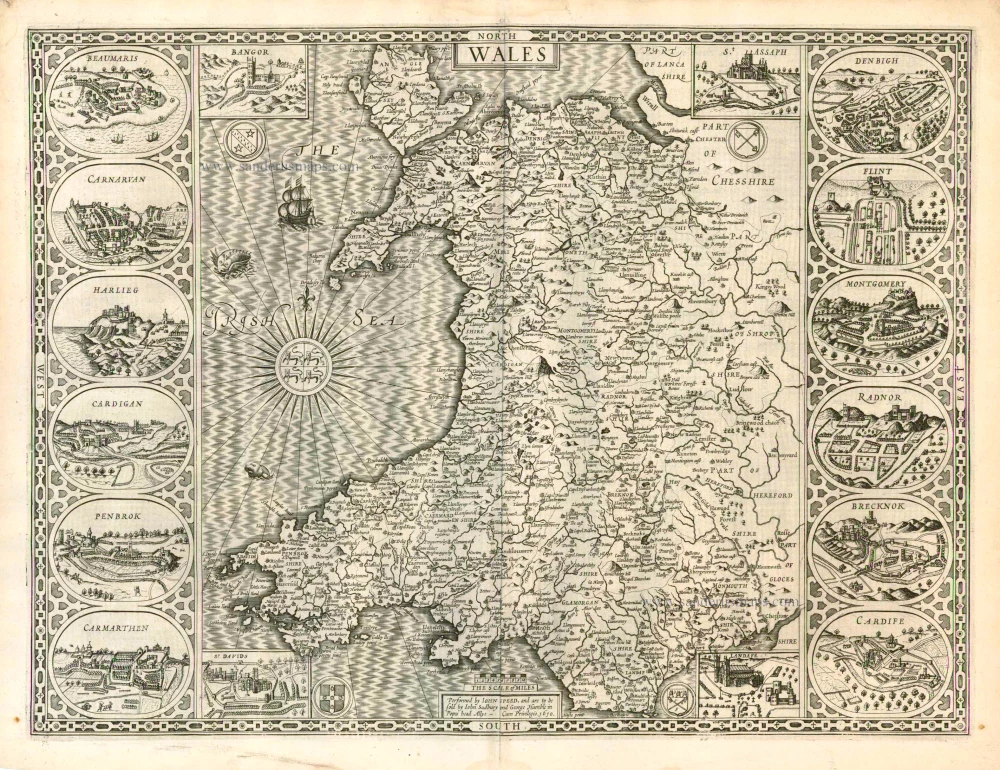
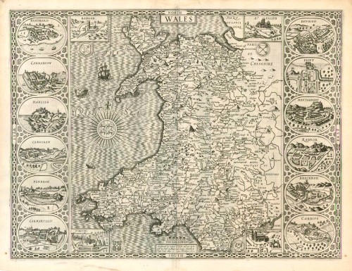
Old antique map of Wales by J. Speed 1616

John Speed (1551/52 – 1629)
John Speed was an English cartographer and historian.
Initially, he worked in his father's tailoring business. He moved to London in 1567. In 1572, John Speed married Susanna Draper from London, who had 12 sons and six daughters.
Due to his excellent knowledge of history, he became known in influential scientific circles. He joined the Antiquarian Society, where he was encouraged to do research work.
In 1595 he published a four-sheet map of Canaan. In the following years, he worked on a series of maps of English counties and cities, which he would later compile in the atlas The Theater of the Empire of Great Britaine, published in 1612. Because the original engraver William Rogers died in 1604, many of the maps were engraved in Amsterdam by Jodocus Hondius. A pocket edition of the atlas, engraved by Pieter Van den Keere, appeared in 1619.
With their detailed town plans and descriptive texts, Speed's maps filled the needs of the time and quickly replaced the earlier Saxton atlases generally in use until then. Not only were they more up to date, but undoubtedly the beauty of the engraving, the fine lettering and the elaborate ornamentation appealed to the original buyers. As a result of the great success of these atlases, a world atlas appeared in 1627: Prospect Of The Most Famous Parts of the World, with 22 to 28 maps, also engraved in Amsterdam. Many of these maps were issued with decorated borders.
Numerous re-editions of these atlases were published, regularly supplemented with new maps.
He died in 1629, one year after his wife, Susanna.
Wales
Item Number: 12560 Authenticity Guarantee
Category: Antique maps > Europe > British Isles
Old, antique map of Wales by J. Speed.
Panels at sides with views of 12 county towns. Inset views of four cities at corners of map.
Date of the first edition: 1616
Date of this map: 1616
Copper engraving
Size: 38 x 51cm (14.8 x 19.9 inches)
Verso text: Latin
Condition: Uncoloured, excellent
Condition Rating: A
From: Theatrum Imperii Magnae Britanniae Regnorum Angliae/Scotiae/Hiberniae et Insularum adiacentium ... London, 1616. (Shirley (Brit.Lib.), T.SPE-1d)
John Speed (1551/52 – 1629)
John Speed was an English cartographer and historian.
Initially, he worked in his father's tailoring business. He moved to London in 1567. In 1572, John Speed married Susanna Draper from London, who had 12 sons and six daughters.
Due to his excellent knowledge of history, he became known in influential scientific circles. He joined the Antiquarian Society, where he was encouraged to do research work.
In 1595 he published a four-sheet map of Canaan. In the following years, he worked on a series of maps of English counties and cities, which he would later compile in the atlas The Theater of the Empire of Great Britaine, published in 1612. Because the original engraver William Rogers died in 1604, many of the maps were engraved in Amsterdam by Jodocus Hondius. A pocket edition of the atlas, engraved by Pieter Van den Keere, appeared in 1619.
With their detailed town plans and descriptive texts, Speed's maps filled the needs of the time and quickly replaced the earlier Saxton atlases generally in use until then. Not only were they more up to date, but undoubtedly the beauty of the engraving, the fine lettering and the elaborate ornamentation appealed to the original buyers. As a result of the great success of these atlases, a world atlas appeared in 1627: Prospect Of The Most Famous Parts of the World, with 22 to 28 maps, also engraved in Amsterdam. Many of these maps were issued with decorated borders.
Numerous re-editions of these atlases were published, regularly supplemented with new maps.
He died in 1629, one year after his wife, Susanna.