
Sea chart of the Isle of Wight and adjacent mainland coastline, by Jacques Nicolas Bellin. 1762

Jacques-Nicolas Bellin (1703-1772)
Jacques-Nicolas Bellin, a French geographer, was among the most important mapmakers of the eighteenth century. In 1721, at the age of 18, he was appointed hydrographer of the Ministry of the Navy following the French hydrographic office's creation and the Dépot of charts and plans of the Navy. Appointed hydrographic engineer in August 1741. Member of the Academy of the Navy and the Royal Society of London.
Over the course of a 50-year career, he drew the maps of several major works of his time such as Histoire et description générale de la Nouvelle-France de Charlevoix (1744); Histoire générale des voyages de l'Abbé Prévost (published between 1746 and 1759) ); Neptune François (1753), Hydrographie Françoise (1756-1765), and Petit Atlas Français (1763) - reissued as Petit Atlas Maritime (1765). He is the most copied cartographer of the 18th century.
His maps of Canada and the French territories of North America are of considerable value. This is all the more remarkable since, an archetype of the cabinet cartographer, Bellin never came to America. For his cartography of the St. Lawrence River, he entrusted handwritten maps to navigators to correct and enrich. With each return of these maps, he was updating his knowledge. Two basic needs drive its cartography of North America: to secure navigation on the St. Lawrence River and to claim for France the lands explored by the French in the Great Lakes region and along the Mississippi River.
Jacques-Nicolas Bellin died on March 21, 1772, in Versailles. In the burial certificate, he is described as "the first engineer of the navy and the deposit of plans, royal censor of the academy of navy and the royal society of London".
Carte Reduite de l'Isle de Wight et Costes Voisines Depuis Selsey jusqu'à la Pointe Peverel.
Item Number: 31426 Authenticity Guarantee
Category: Antique maps > Europe > British Isles
Sea chart of the Isle of Wight and adjacent mainland coastline, by Jacques Nicolas Bellin.
Title: Carte Reduite de l'Isle de Wight et Costes Voisines Depuis Selsey jusqu'à la Pointe Peverel.
Avec les Ports Rades et Mouillages et le Détail de l'Interieur du Pais.
Dressée au Depost des Cartes Plans et Journeaux de la Marine
Pour le Service des Vaisseaux du Roy.
Par ordre de M. Le Duc de Choiseuil Ministre de la Guerre et de la Marine.
Par l;e Sr Bellin Ingr de la Marine et du depost des Plans, Censeur Royale de Londres. 1762.
Date: 1762.
Date on map: 1762.
Copper engraving, printed on paper.
Image size: 555 x 855mm (21¾ x 33¾ inches).
Sheet size: 615 x 900mm (24¼ x 35½ inches).
Verso: Blank.
Condition: Hand coloured, excellent.
Condition Rating: A+.
From: L'Hydrographie Françoise ou Recueil des Cartes Dressées au Deposit des Plans de la Marine pour le Service des Vaisseaux du Roy. Paris, 1756-70. (Shirley (Brit.Lib.), M.Bell-2a)
Jacques-Nicolas Bellin (1703-1772)
Jacques-Nicolas Bellin, a French geographer, was among the most important mapmakers of the eighteenth century. In 1721, at the age of 18, he was appointed hydrographer of the Ministry of the Navy following the French hydrographic office's creation and the Dépot of charts and plans of the Navy. Appointed hydrographic engineer in August 1741. Member of the Academy of the Navy and the Royal Society of London.
Over the course of a 50-year career, he drew the maps of several major works of his time such as Histoire et description générale de la Nouvelle-France de Charlevoix (1744); Histoire générale des voyages de l'Abbé Prévost (published between 1746 and 1759) ); Neptune François (1753), Hydrographie Françoise (1756-1765), and Petit Atlas Français (1763) - reissued as Petit Atlas Maritime (1765). He is the most copied cartographer of the 18th century.
His maps of Canada and the French territories of North America are of considerable value. This is all the more remarkable since, an archetype of the cabinet cartographer, Bellin never came to America. For his cartography of the St. Lawrence River, he entrusted handwritten maps to navigators to correct and enrich. With each return of these maps, he was updating his knowledge. Two basic needs drive its cartography of North America: to secure navigation on the St. Lawrence River and to claim for France the lands explored by the French in the Great Lakes region and along the Mississippi River.
Jacques-Nicolas Bellin died on March 21, 1772, in Versailles. In the burial certificate, he is described as "the first engineer of the navy and the deposit of plans, royal censor of the academy of navy and the royal society of London".
Related items

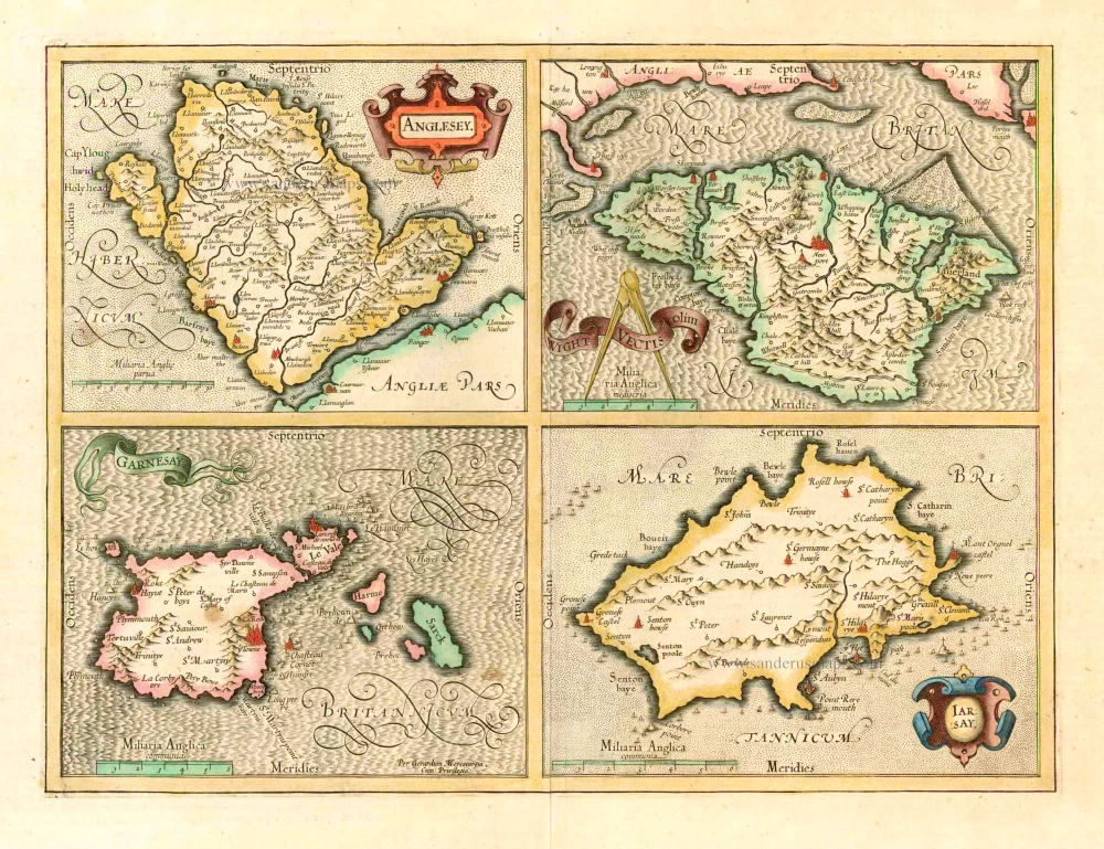
Anglesey [on sheet with] Wight ol. Vectis [and] Garnesay [and] Iarsay 1607
Anglesey, Wight & Channel Islands, by Gerard Mercator.
[Item number: 13705]

Carte Particulière des Costes Méridionales d'Angleterre Qui comprend l'Isle de Wight ... 1693
England, Isle of Wight & Hampshire, by P. Mortier.
[Item number: 15482]
Anglesey - Wight Vectis Olim - Garnesay - Iarsay 1619
Anglesey, Wight, Guernsey and Jersey by Jodocus Hondius.
[Item number: 25158]

Vectis Insula Anglice. The Isle of Wight. 1645
Isle of Wight, by J. Blaeu.
[Item number: 25754]
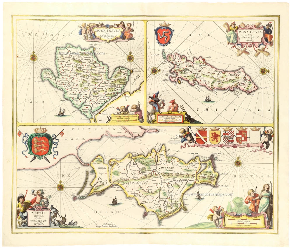
Mona Insula Vulgo Anglesey - Vectis Insula Vulgo The Isle of Man - Vectis Insula Anglice The Isle of Wight. 1646
Anglesey - Isle of Man - Isle of Wight by Janssonius J.
[Item number: 33154]
new