
Petrinja in Croatia, by Georg Braun and Frans Hogenberg. c. 1625


Braun G. & Hogenberg F. and the Civitates Orbis Terrarum.
The Civitates Orbis Terrarum, also known as the 'Braun & Hogenberg', is a six-volume town atlas and the most excellent book of town views and plans ever published: 363 engravings, sometimes beautifully coloured. It was one of the best-selling works in the last quarter of the 16th century. Georg Braun, a skilled writer, wrote the text accompanying the plans and views on the verso. Many plates were engraved after the original drawings of a professional artist, Joris Hoefnagel (1542-1600). The first volume was published in Latin in 1572 and the sixth in 1617. Frans Hogenberg, a talented engraver, created the tables for volumes I through IV, and Simon van den Neuwel made those for volumes V and VI. Other contributors were cartographers Daniel Freese and Heinrich Rantzau, who provided valuable geographical information. Works by Jacob van Deventer, Sebastian Münster, and Johannes Stumpf were also used as references. Translations appeared in German and French, making the atlas accessible to a broader audience.
Since its original publication of volume 1 in 1572, the Civitates Orbis Terrarum has left an indelible mark on the history of cartography. Seven more editions followed the first volume in 1575, 1577, 1582, 1588, 1593, 1599, and 1612. Vol.2, initially released in 1575, saw subsequent editions in 1597 and 1612. The subsequent volumes, each a treasure trove of historical insights, graced the world in 1581, 1588, 1593, 1599, and 1606. The German translation of the first volume, a testament to its widespread appeal, debuted in 1574, followed by the French edition in 1575.
Several printers were involved: Theodor Graminaeus, Heinrich von Aich, Gottfried von Kempen, Johannis Sinniger, Bertram Buchholtz, and Peter von Brachel, all of whom worked in Cologne.
Georg Braun (1541-1622)
Georg Braun, the author of the text accompanying the plans and views in the Civitates Orbis Terrarum, was born in Cologne in 1541. After his studies in Cologne, he entered the Jesuit Order as a novice, indicating his commitment to learning and intellectual pursuits. In 1561, he obtained his bachelor's degree; in 1562, he received his Magister Artium, further demonstrating his academic achievements. Although he left the Jesuit Order, he continued his studies in theology, gaining a licentiate in theology. His theological background likely influenced the content and tone of the text in the Civitates Orbis Terrarum, adding a unique perspective to the work.
Frans Hogenberg (1535-1590)
Frans Hogenberg was a Flemish and German painter, engraver, and mapmaker. He was born in Mechelen as the son of Nicolaas Hogenberg.
By the end of the 1560s, Frans Hogenberg was employed upon Abraham Ortelius's Theatrum Orbis Terrarum, published in 1570; he is named an engraver of numerous maps. In 1568, he was banned from Antwerp by the Duke of Alva and travelled to London, where he stayed a few years before emigrating to Cologne. He immediately embarked on his two most important works, the Civitates, published in 1572 and the Geschichtsblätter, which appeared in several series from 1569 until about 1587.
Thanks to large-scale projects like the Geschichtsblätter and the Civitates, Hogenberg's social circumstances improved with each passing year. He died as a wealthy man in Cologne in 1590.
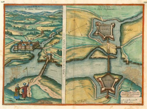
Petrina in ditione Turcarum.[on sheet with] Petrina in ditione Christianorum.
Item Number: 16384 Authenticity Guarantee
Category: Antique maps > Europe > Central Europe
Antique map - Bird's-eye view and plan of Petrinja in Croatia by Braun and Hogenberg after G. Hoefnagel. 1617.
CAPTION LEFT: Petrinja. Under Turhish rule.
CAPTION CENTRE: Received from a friend by Georg Hoefnagel, who finished painting it and passed it on in the year 1597.
CAPTION RIGHT: Petrinja. Under Christian rule.
CARTOUCHE: These fortifications are due to the skill and industriousness of the Italian architect Cesare Porta, in the year 1617.
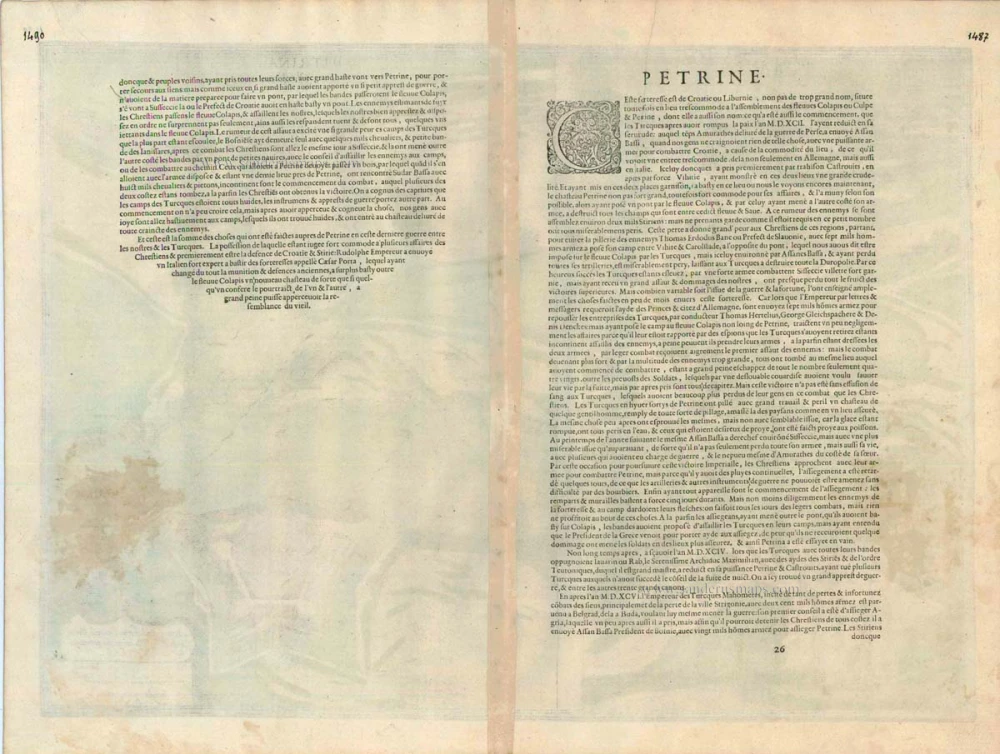
COMMENTARY BY BRAUN (on verso): "It became known only in the year 1592 that Sultan Murad, after having ended the war with the King of Persia, immediately afterwards broke the peace he had concluded with the Christians. He ordered Hasan Pasha to invade Croatia and capture all fortified places, so that it would be easier to reach Italy from there. The Pasha obeyed his orders faithfully and conquered first Hrastovica by treachery and then Bihac by force, on which occasion he proceeded with excessive tyranny. Soon afterwards he built the fortress of Petrinja in a very advantageous location with natural fortifications, and manned it with a large number of soldiers. Because this fort was very important, being as it were a key to Styria and Croatia, His Majesty the Emperor appointed an experienced fortress builder by the name of Cesare Porta, who pulled down the old castle almost completely and in place of the walls and towers built earthen ramparts and bastions, and a new castle with a bridge on the other side of the Kupa."
After the Turkish conquests in the 16th century, western Croatia remained under the rule of the Habsburgs. In 1592 the Ottomans built a base near the town of Petrinja on the Kupa, the boundary river, and in 1593 Hasan Pasha, its commander, crossed the Kupa but suffered a crushing defeat soon thereafter at the hands of the Croation Habsburg troops in the Battle of Sisak. The engraving on the left shows the Turkish fort and massiver watchtowers in cavalier perspective from the northwest. A cannon is being fired from the tower in the middle ground. In the foreground is a couple in Turkish dress: the man, whose clothes identify him as a high-ranking Janissary (possibly Hasan Pasha), has planted the shaft of a crescent flag on the ground - a demonstration of the Ottoman claim to the regions on this side of the Kupa. In 1594 Petrinja was recaptured by the Habsburgs and a new, more modern fortress was erected. The engraving on the right must be seen as complementing the one on the left. It is an isometric plan of the moated castle. The most progressive fortress of its time is presented in the most modern cartographic form then existing. The river crossing is secured by two pentagonal bastioned ramparts of equal size, ensuring that there is no blind spot for the defenders. Petrinja was henceforth located within that defence belt of the Austrian military border known as Krajina, in which Serbian and Croatian soldier-farmers settled and lived together peacefully up to the early 1990s. (Taschen)
Date of the first edition: 1617
Date of this map: c. 1625
Copper engraving
Size: 36.5 x 51cm (14.2 x 19.8 inches)
Verso text: French
Condition: Contemporary coloured, two brown stains.
Condition Rating: B
References: Van der Krogt 4, 3375; Taschen, Braun and Hogenberg, p. 472.
From: Théatre des Principales Villes de tout l'Univers Vol. VI. c. 1625. (Van der Krogt 4, 41:3.6)
Braun G. & Hogenberg F. and the Civitates Orbis Terrarum.
The Civitates Orbis Terrarum, also known as the 'Braun & Hogenberg', is a six-volume town atlas and the most excellent book of town views and plans ever published: 363 engravings, sometimes beautifully coloured. It was one of the best-selling works in the last quarter of the 16th century. Georg Braun, a skilled writer, wrote the text accompanying the plans and views on the verso. Many plates were engraved after the original drawings of a professional artist, Joris Hoefnagel (1542-1600). The first volume was published in Latin in 1572 and the sixth in 1617. Frans Hogenberg, a talented engraver, created the tables for volumes I through IV, and Simon van den Neuwel made those for volumes V and VI. Other contributors were cartographers Daniel Freese and Heinrich Rantzau, who provided valuable geographical information. Works by Jacob van Deventer, Sebastian Münster, and Johannes Stumpf were also used as references. Translations appeared in German and French, making the atlas accessible to a broader audience.
Since its original publication of volume 1 in 1572, the Civitates Orbis Terrarum has left an indelible mark on the history of cartography. Seven more editions followed the first volume in 1575, 1577, 1582, 1588, 1593, 1599, and 1612. Vol.2, initially released in 1575, saw subsequent editions in 1597 and 1612. The subsequent volumes, each a treasure trove of historical insights, graced the world in 1581, 1588, 1593, 1599, and 1606. The German translation of the first volume, a testament to its widespread appeal, debuted in 1574, followed by the French edition in 1575.
Several printers were involved: Theodor Graminaeus, Heinrich von Aich, Gottfried von Kempen, Johannis Sinniger, Bertram Buchholtz, and Peter von Brachel, all of whom worked in Cologne.
Georg Braun (1541-1622)
Georg Braun, the author of the text accompanying the plans and views in the Civitates Orbis Terrarum, was born in Cologne in 1541. After his studies in Cologne, he entered the Jesuit Order as a novice, indicating his commitment to learning and intellectual pursuits. In 1561, he obtained his bachelor's degree; in 1562, he received his Magister Artium, further demonstrating his academic achievements. Although he left the Jesuit Order, he continued his studies in theology, gaining a licentiate in theology. His theological background likely influenced the content and tone of the text in the Civitates Orbis Terrarum, adding a unique perspective to the work.
Frans Hogenberg (1535-1590)
Frans Hogenberg was a Flemish and German painter, engraver, and mapmaker. He was born in Mechelen as the son of Nicolaas Hogenberg.
By the end of the 1560s, Frans Hogenberg was employed upon Abraham Ortelius's Theatrum Orbis Terrarum, published in 1570; he is named an engraver of numerous maps. In 1568, he was banned from Antwerp by the Duke of Alva and travelled to London, where he stayed a few years before emigrating to Cologne. He immediately embarked on his two most important works, the Civitates, published in 1572 and the Geschichtsblätter, which appeared in several series from 1569 until about 1587.
Thanks to large-scale projects like the Geschichtsblätter and the Civitates, Hogenberg's social circumstances improved with each passing year. He died as a wealthy man in Cologne in 1590.