
Bohemia, by Abraham Ortelius 1574
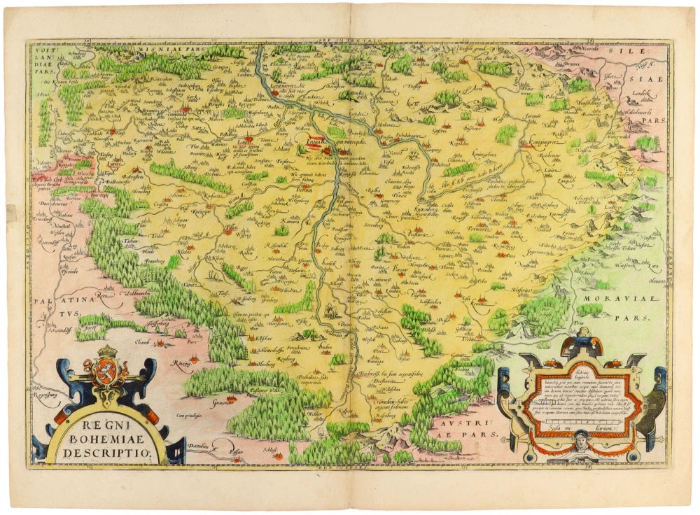
A finely engraved early map of Bohemia (present-day Czech Republic), published by Abraham Ortelius (1527–1598) in the 1574 Latin edition of his celebrated Theatrum Orbis Terrarum, the first modern atlas. The map is based on the geographical work of Johann Criginger (1521–1571), a German theologian, mathematician and cartographer, whose pioneering representation of Bohemia became an important source for sixteenth-century cartography.
First published in Ortelius's atlas in 1570, the map provides a remarkably detailed representation of the Kingdom of Bohemia, then part of the Habsburg dominions within the Holy Roman Empire. It is oriented with north at the top and extends beyond Bohemia into the neighbouring regions of Saxony, Silesia, Moravia, the Upper Palatinate and Austria.
The map is particularly notable for its unusual emphasis on the physical landscape. Extensive forests, mountain ranges and wooded hills are depicted pictorially, with densely engraved clusters of trees and carefully delineated relief features. Rivers form an intricate network across the country, with the Elbe (Albis) and Vltava (Moldau) prominently represented. Numerous towns, villages, castles and settlements are identified, including Prague (Praga), which occupies a central position in the composition.
The title, Regni Bohemiae Descriptio, appears in a splendid Renaissance cartouche in the lower left corner, surmounted by an elaborate heraldic ornament displaying the crowned Bohemian lion. A second richly decorated cartouche in the lower right corner contains a Latin geographical description of the country and a mile scale. Both cartouches are characteristic of the refined ornamental engraving found in Ortelius's earliest atlas maps.
The map derives from Johann Criginger's work, whose original map of Bohemia, produced in the 1560s, was among the earliest detailed cartographic representations of the kingdom. Ortelius reduced and adapted Criginger's geographical information for inclusion in his Theatrum Orbis Terrarum, first published in Antwerp in 1570.
The Theatrum marked a decisive development in the history of cartography. For the first time, maps of different regions, based on the work of leading contemporary geographers, were systematically assembled into a uniform atlas, accompanied by descriptive texts and references to their sources. Ortelius's map of Bohemia is a particularly fine example of this achievement, combining contemporary geographical knowledge with the artistic conventions of Renaissance mapmaking.
Abraham Ortelius (1527-1598)
The maker of the 'first atlas', the Theatrum Orbis Terrarum (1570), was born on 4 April 1527 into an old Antwerp family. He learned Latin and studied Greek and mathematics.
Abraham and his sisters, Anne and Elizabeth, took up map colouring. Ortelius was admitted to the Guild of St. Luke as an "illuminator of maps." In addition to colouring maps, Ortelius was a dealer in antiques, coins, maps, and books, and the book and map trade gradually became his primary occupation.
Business went well because his means allowed him to amass an extensive collection of medals, coins, and antiques, as well as a library of many volumes. In addition, he travelled extensively, visited Italy and France, made contacts with scholars and editors everywhere, and maintained extensive correspondence with them.
In 1564, he published his first map, a large and ambitious world wall map. The inspiration for this map may well have been Gastaldi's large world map. In 1565, he published a map of Egypt and a map of the Holy Land; a large map of Asia followed.
In 1568, the production of individual maps for his atlas Theatrum Orbis Terrarum was already in full swing. He completed the atlas in 1569, and in May 1570, it was available for sale. It was one of the most expensive books ever published.
This first edition contained seventy maps on fifty-three sheets. Franciscus Hogenberg engraved the maps.
Later editions included Additamenta (additions), resulting in Ortelius' historical atlas, the Parergon, which is mainly bound together with the atlas. The Parergon can be considered a truly original work by Ortelius, who drew the maps based on his research.
The importance of the Theatrum Orbis Terrarum for geographical knowledge in the last quarter of the sixteenth century is difficult to overemphasise. Nothing was like it until Mercator's atlas appeared twenty-five years later. Demand for the Theatrum was remarkable. Some 24 editions appeared during Ortelius's lifetime, and another 10 after he died in 1598. Editions were published in Dutch, German, French, Spanish, English, and Italian. The number of map sheets grew from 53 in 1570 to 167 in the last edition in 1612.
In 1577, engraver Philip Galle and poet-translator Pieter Heyns published the first pocket-sized edition of the Theatrum, the Epitome. The work was trendy. Over thirty editions of this Epitome were published in different languages.
Ortelius is also remembered for an early idea resembling continental drift: he suggested that the Americas, Europe, and Africa may once have been joined together before separating over time. His work helped shape the development of modern geography and mapmaking.
Regni Bohemiae Descriptio.
Item Number: 33397 new Authenticity Guarantee
Category: Antique maps > Europe > Central Europe
Bohemia, by Abraham Ortelius.
Title: Regni Bohemiae Descriptio.
Cartographer: Johann Criginger.
Date of the first edition: 1570.
Date of this map: 1574.
Copper engraving, printed on paper.
Image size: 335 x 505mm (13¼ x 20 inches).
Sheet size: 395 x 530mm (15½ x 20¾ inches).
Verso: Latin text.
Condition: Hand-coloured, excellent.
Condition Rating: A.
From: Theatrum Orbis Terrarum Antwerpen, Anthonis Coppens van Diest, 1574. (Van der Krogt 3, 31:012)
A finely engraved early map of Bohemia (present-day Czech Republic), published by Abraham Ortelius (1527–1598) in the 1574 Latin edition of his celebrated Theatrum Orbis Terrarum, the first modern atlas. The map is based on the geographical work of Johann Criginger (1521–1571), a German theologian, mathematician and cartographer, whose pioneering representation of Bohemia became an important source for sixteenth-century cartography.
First published in Ortelius's atlas in 1570, the map provides a remarkably detailed representation of the Kingdom of Bohemia, then part of the Habsburg dominions within the Holy Roman Empire. It is oriented with north at the top and extends beyond Bohemia into the neighbouring regions of Saxony, Silesia, Moravia, the Upper Palatinate and Austria.
The map is particularly notable for its unusual emphasis on the physical landscape. Extensive forests, mountain ranges and wooded hills are depicted pictorially, with densely engraved clusters of trees and carefully delineated relief features. Rivers form an intricate network across the country, with the Elbe (Albis) and Vltava (Moldau) prominently represented. Numerous towns, villages, castles and settlements are identified, including Prague (Praga), which occupies a central position in the composition.
The title, Regni Bohemiae Descriptio, appears in a splendid Renaissance cartouche in the lower left corner, surmounted by an elaborate heraldic ornament displaying the crowned Bohemian lion. A second richly decorated cartouche in the lower right corner contains a Latin geographical description of the country and a mile scale. Both cartouches are characteristic of the refined ornamental engraving found in Ortelius's earliest atlas maps.
The map derives from Johann Criginger's work, whose original map of Bohemia, produced in the 1560s, was among the earliest detailed cartographic representations of the kingdom. Ortelius reduced and adapted Criginger's geographical information for inclusion in his Theatrum Orbis Terrarum, first published in Antwerp in 1570.
The Theatrum marked a decisive development in the history of cartography. For the first time, maps of different regions, based on the work of leading contemporary geographers, were systematically assembled into a uniform atlas, accompanied by descriptive texts and references to their sources. Ortelius's map of Bohemia is a particularly fine example of this achievement, combining contemporary geographical knowledge with the artistic conventions of Renaissance mapmaking.
Abraham Ortelius (1527-1598)
The maker of the 'first atlas', the Theatrum Orbis Terrarum (1570), was born on 4 April 1527 into an old Antwerp family. He learned Latin and studied Greek and mathematics.
Abraham and his sisters, Anne and Elizabeth, took up map colouring. Ortelius was admitted to the Guild of St. Luke as an "illuminator of maps." In addition to colouring maps, Ortelius was a dealer in antiques, coins, maps, and books, and the book and map trade gradually became his primary occupation.
Business went well because his means allowed him to amass an extensive collection of medals, coins, and antiques, as well as a library of many volumes. In addition, he travelled extensively, visited Italy and France, made contacts with scholars and editors everywhere, and maintained extensive correspondence with them.
In 1564, he published his first map, a large and ambitious world wall map. The inspiration for this map may well have been Gastaldi's large world map. In 1565, he published a map of Egypt and a map of the Holy Land; a large map of Asia followed.
In 1568, the production of individual maps for his atlas Theatrum Orbis Terrarum was already in full swing. He completed the atlas in 1569, and in May 1570, it was available for sale. It was one of the most expensive books ever published.
This first edition contained seventy maps on fifty-three sheets. Franciscus Hogenberg engraved the maps.
Later editions included Additamenta (additions), resulting in Ortelius' historical atlas, the Parergon, which is mainly bound together with the atlas. The Parergon can be considered a truly original work by Ortelius, who drew the maps based on his research.
The importance of the Theatrum Orbis Terrarum for geographical knowledge in the last quarter of the sixteenth century is difficult to overemphasise. Nothing was like it until Mercator's atlas appeared twenty-five years later. Demand for the Theatrum was remarkable. Some 24 editions appeared during Ortelius's lifetime, and another 10 after he died in 1598. Editions were published in Dutch, German, French, Spanish, English, and Italian. The number of map sheets grew from 53 in 1570 to 167 in the last edition in 1612.
In 1577, engraver Philip Galle and poet-translator Pieter Heyns published the first pocket-sized edition of the Theatrum, the Epitome. The work was trendy. Over thirty editions of this Epitome were published in different languages.
Ortelius is also remembered for an early idea resembling continental drift: he suggested that the Americas, Europe, and Africa may once have been joined together before separating over time. His work helped shape the development of modern geography and mapmaking.
Related items

Polna vulgo Polm insign: Bohemiae civitas Regnum a Moravia dividens.. c. 1625
Polna in Bohemia, by Georg Braun and Frans Hogenberg.
[Item number: 16423]
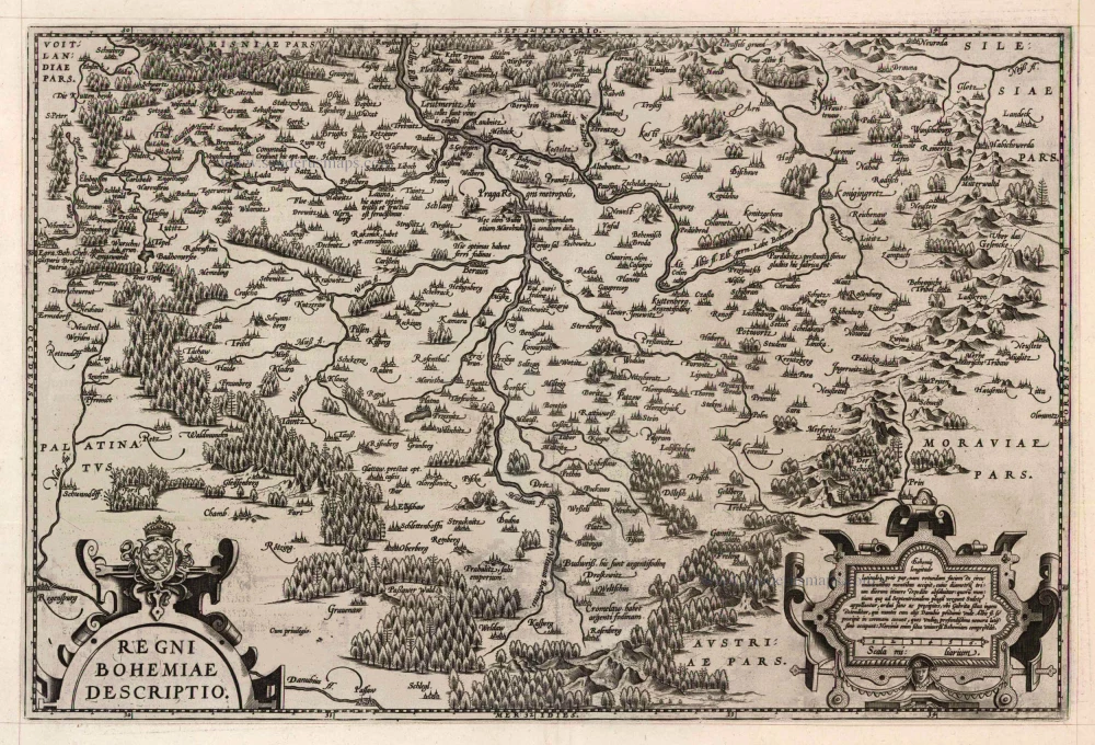
Regni Bohemiae Descriptio. 1598
Bohemia by Ortelius Abraham
[Item number: 22912]

Praga, Bohemiae Metropolis Accuratissime Expressa [on sheet with] Egra, Urbs a Fluvio ... 1599
Prague (Praha) and Cheb in Bohemia, by Georg Braun and Frans Hogenberg.
[Item number: 23924]

Regnum Bohemia, eique Annexae Provinciae, ut Ducatus Silesia, Marchionatus Moravia, et Lusatia ... c. 1682-86
Bohemia (Czech Republic), by Frederik De Wit.
[Item number: 24430]

La Boheme. 1713
Bohemia, by Pieter van der Aa.
[Item number: 26179]

Regnum Bohemia, eique Annexae Provinciae, ut Ducatus Silesia, Marchionatus Moravia, et Lusatia quae sunt Terrae Haereditariae Imperatoris. after 1721
Bohemia by Frederik de Wit, published by Covens & Mortier.
[Item number: 28332]

Bohemia. 1640
Bohemia by Willem Blaeu.
[Item number: 28659]

Provinces Unies, et incorporées a la Couronne de Boheme; qui sont les Duché de Silesie, Marq[ui]sats de Moravie, et de Lusace. 1658
Bohemia par Nicolas Sanson.
[Item number: 29667]

Konigreich Boheim. - Royaume de Boheme. 1658
Bohemia by Nicolas Sanson.
[Item number: 29670]

Bohemia. 1653
Bohemia by Johannes Janssonius.
[Item number: 30394]

Estats de la Couronne de Boheme qui comprennent Le Royaume de Boheme le Duché de Silesie et les Marquisats de Moravie et de Lusace. 1692
Bohemia (Czech Republic) by N. Sanson, so-called published by Hubert Jaillot. (Pirated edition by Pierre Mortier).
[Item number: 31406]

Bohemia. 1618
Bohemia by Petrus Bertius, published by Jodocus Hondius II.
[Item number: 31649]

Regno di Boemia, Ducato di Silesia, e Marchesati di Moravia, e Lusazia. 1779-1785
Bohemia by Antonio Zatta.
[Item number: 31805]

Parte Orientale del Regno di Boemia. 1779-1785
Bohemia (East) by Antonio Zatta.
[Item number: 31806]

RARE
Regnum Bohemia, eique Annexae Provinciae ut Ducatus Silesia Marchionatus Moravia, et Lusata quae sunt Terrae Haereditariae Imperatoris. c. 1700
Bohemia (Czech Republic) by Theodore Danckerts
[Item number: 32511]

Regni Bohemiae, ducatus Silesiae, Marchionatus Moraviae et Lusatiae Tabula Generalis. 1712
Bohemia, Silesia Moravia, Lusatia (Sorbia), by J.B. Homann.
[Item number: 33260]