
Impressive six-sheet map of the Danube River
Course of the Danube River by V.M. Coronelli. 1691
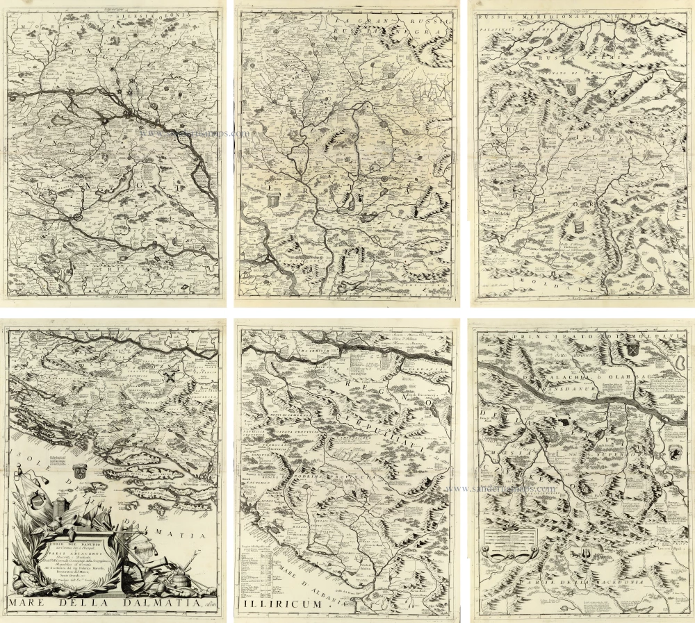
An impressive and exceptionally detailed six-sheet map of the River Danube and the surrounding territories of Central and Southeastern Europe.
The map follows the course of the Danube from Vienna through Hungary, Croatia, Serbia and the adjoining territories to Nicopolis (Nikopol) in present-day Bulgaria. It encompasses an extensive geographical area, including parts of Austria, Hungary, Slovakia, Croatia, Bosnia, Serbia, Romania, Bulgaria and the neighbouring regions.
The six sheets together form a monumental cartographic composition, remarkable for its geographical detail and elaborate engraving. Numerous towns, villages, fortresses, rivers, lakes, roads and mountain ranges are carefully delineated. The Danube and its principal tributaries, including the Drava, Sava, Tisza and Morava, are prominently represented, together with the extensive network of waterways that shaped the political, economic and military geography of the region.
The map is particularly significant for its depiction of the territories contested between the Habsburg monarchy and the Ottoman Empire during the Great Turkish War (1683–1699). Following the unsuccessful Ottoman siege of Vienna in 1683, the Habsburg armies launched a series of campaigns that profoundly altered the balance of power in Central Europe. The capture of Buda in 1686 and Belgrade in 1688 marked important stages in the Christian reconquest of territories previously controlled by the Ottomans.
Coronelli's map reflects the intense European interest in these military campaigns and provides a valuable geographical record of the frontier regions during this period of political and territorial transformation. Particular attention is devoted to fortified towns, strategic river crossings, mountain passes and the principal routes connecting the Danube with the surrounding provinces.
The geographical representation is enriched by finely engraved mountain ranges, forests and extensive river systems. The individual sheets identify numerous historical regions and administrative divisions, preserving contemporary place names and political terminology.
A striking feature is the magnificent decorative title cartouche, situated on the sheet depicting the Dalmatian coast. The cartouche is surrounded by an elaborate arrangement of military trophies, banners, weapons, armour and other martial emblems, reflecting the strategic importance of the region and the military conflicts of the period.
Several heraldic shields and additional geographical annotations appear throughout the composition, contributing to the map's historical and decorative interest.
An outstanding example of late seventeenth-century Italian cartography, combining exceptional geographical detail, magnificent Baroque engraving and considerable historical importance as a record of the Habsburg–Ottoman frontier during the Great Turkish War.
Vincenzo Coronelli (1650-1718)
Vincenzo Coronelli was born in Venice on 16 August 1650 and primarily brought up in Ravenna. He returned to Venice in 1665 and joined the convent of the Minor Conventuals. Five years later, he was sent to Rome to study, and by 1673, he was already a doctor of theology.
Having achieved fame by constructing two globes for the Duke of Parma, he was invited to Paris for three years in 1681 and made two enormous examples for Louis XIV. On his return to Venice, he assiduously collected cartographic material and founded the Academy of the Argonauts. In 1685, he was appointed Cosmographer to the Republic of Venice and authorised to publish a large atlas. He became a geography lecturer at the University of Venice and brought out an Atlante Veneto the following year.
In 1696, he visited Germany, Holland and southern England. During intervals in compiling his vast encyclopaedia, he continued with cartographic projects up to 1709. He died in his native Venice on 9 December 1718.
Coronelli became famous for his globes. In addition, he was a renowned encyclopaedist, mapmaker and geographer. Most of his maps and other material are gathered in his Atlante Veneto (13 vols, 1690-1705). The first volume, subtitled Descrizione generale istorica geografica, was his masterpiece, planned as an extension of Blaeu’s atlas.
Other volumes of the atlas which contain maps are Isolario, two parts (1696-8), with detailed maps and plans, mostly of islands; Corso geografico, two parts based on the edition 1694-7; Libro de’ globi (1697); and Lo Specchio del Mare, a reprint of Levanto's Lo Specchio del Mare Mediterraneo of 1664.
The other vital aspects of his mapping are those arising from the Venetian conquest and his travels. His most extensive military compilation was the Teatro della Guerra, in more than 30 volumes.
Corso del Danubio da Vienna sin' a Nicopoli e Paesi Adiacenti
Item Number: 33373 new Authenticity Guarantee
Category: Antique maps > Europe > Central Europe
Course of the Danube River by V.M. Coronelli.
Title: Corso del Danubio da Vienna sin' a Nicopoli e Paesi Adiacenti
Descritti, e Dedicati Dal P.M. Coronelli Cosmografo della Serenißima Republica di Venetia ...
Con Privilegio dell' Ecc:mo Senato
Date of the first edition: 1691.
Date of this map: 1691.
Copper engravings, printed on six sheets of paper, unjoined.
Approximate overall size when joined: 1200 x 1350mm (47¼ x 53¼ inches).
Sheet size each: 650 x 475mm (25½ x 18¾ inches).
Verso: Blank.
Condition: Excellent.
Condition Rating: A+.
From: Atlante Veneto, nel quale si contiene la descrittione... degl' Imperii, Regni, Provincie, e Stati dell' Universo. Venice: Girolamo Albrizzi, 1691. Shirley (Brit.Lib.), T.CORO-7a
An impressive and exceptionally detailed six-sheet map of the River Danube and the surrounding territories of Central and Southeastern Europe.
The map follows the course of the Danube from Vienna through Hungary, Croatia, Serbia and the adjoining territories to Nicopolis (Nikopol) in present-day Bulgaria. It encompasses an extensive geographical area, including parts of Austria, Hungary, Slovakia, Croatia, Bosnia, Serbia, Romania, Bulgaria and the neighbouring regions.
The six sheets together form a monumental cartographic composition, remarkable for its geographical detail and elaborate engraving. Numerous towns, villages, fortresses, rivers, lakes, roads and mountain ranges are carefully delineated. The Danube and its principal tributaries, including the Drava, Sava, Tisza and Morava, are prominently represented, together with the extensive network of waterways that shaped the political, economic and military geography of the region.
The map is particularly significant for its depiction of the territories contested between the Habsburg monarchy and the Ottoman Empire during the Great Turkish War (1683–1699). Following the unsuccessful Ottoman siege of Vienna in 1683, the Habsburg armies launched a series of campaigns that profoundly altered the balance of power in Central Europe. The capture of Buda in 1686 and Belgrade in 1688 marked important stages in the Christian reconquest of territories previously controlled by the Ottomans.
Coronelli's map reflects the intense European interest in these military campaigns and provides a valuable geographical record of the frontier regions during this period of political and territorial transformation. Particular attention is devoted to fortified towns, strategic river crossings, mountain passes and the principal routes connecting the Danube with the surrounding provinces.
The geographical representation is enriched by finely engraved mountain ranges, forests and extensive river systems. The individual sheets identify numerous historical regions and administrative divisions, preserving contemporary place names and political terminology.
A striking feature is the magnificent decorative title cartouche, situated on the sheet depicting the Dalmatian coast. The cartouche is surrounded by an elaborate arrangement of military trophies, banners, weapons, armour and other martial emblems, reflecting the strategic importance of the region and the military conflicts of the period.
Several heraldic shields and additional geographical annotations appear throughout the composition, contributing to the map's historical and decorative interest.
An outstanding example of late seventeenth-century Italian cartography, combining exceptional geographical detail, magnificent Baroque engraving and considerable historical importance as a record of the Habsburg–Ottoman frontier during the Great Turkish War.
Vincenzo Coronelli (1650-1718)
Vincenzo Coronelli was born in Venice on 16 August 1650 and primarily brought up in Ravenna. He returned to Venice in 1665 and joined the convent of the Minor Conventuals. Five years later, he was sent to Rome to study, and by 1673, he was already a doctor of theology.
Having achieved fame by constructing two globes for the Duke of Parma, he was invited to Paris for three years in 1681 and made two enormous examples for Louis XIV. On his return to Venice, he assiduously collected cartographic material and founded the Academy of the Argonauts. In 1685, he was appointed Cosmographer to the Republic of Venice and authorised to publish a large atlas. He became a geography lecturer at the University of Venice and brought out an Atlante Veneto the following year.
In 1696, he visited Germany, Holland and southern England. During intervals in compiling his vast encyclopaedia, he continued with cartographic projects up to 1709. He died in his native Venice on 9 December 1718.
Coronelli became famous for his globes. In addition, he was a renowned encyclopaedist, mapmaker and geographer. Most of his maps and other material are gathered in his Atlante Veneto (13 vols, 1690-1705). The first volume, subtitled Descrizione generale istorica geografica, was his masterpiece, planned as an extension of Blaeu’s atlas.
Other volumes of the atlas which contain maps are Isolario, two parts (1696-8), with detailed maps and plans, mostly of islands; Corso geografico, two parts based on the edition 1694-7; Libro de’ globi (1697); and Lo Specchio del Mare, a reprint of Levanto's Lo Specchio del Mare Mediterraneo of 1664.
The other vital aspects of his mapping are those arising from the Venetian conquest and his travels. His most extensive military compilation was the Teatro della Guerra, in more than 30 volumes.
Related items

Maximi Totius Europae Fluminis Danubii Cursus per Germaniam Hungariamque Nova Delineatio. 1647
Danube River, by Henricus Hondius.
[Item number: 28131]

Danubii Fluvii Sive Turcici Imperii in Europa. c. 1705
Danube and European Ottoman Empire, by Frederick de Wit.
[Item number: 29279]
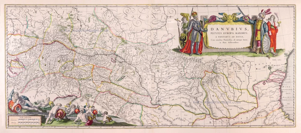
Danubius, Fluvius Europae Maximus, a Fontibus ad Ostia, Cum omnibus Fluminibus, ab utroque latere, in illum defluentibus. 1643
Danube River by Willem Blaeu.
[Item number: 30307]

Spectacular map
Le Cours du Danube depuis sa Source jusqu'à ses Embouchures. 1692
Course of the Danube River by N. Sanson, so-called published by Hubert Jaillot. (Pirated edition by Pierre Mortier).
[Item number: 31196]

Corso del Danubio da Belgrado fino al Mar Ner 1687
Lower Danube by Giacomo Cantelli da Vignola, by Giovanni de Rossi.
[Item number: 32921]

Maximi Totius Europae Fluminis Danubii Cursus per Germaniam Hungariamque Nova Delineatio. c. 1620-1650
Danube River, by Henricus Hondius.
[Item number: 33146]