
Hungary, by Pieter van der Aa. 1713

Pieter van der Aa (Leiden, 1659-1733)
Pieter van der Aa was already in 1682 owner of a bookshop and auction house. During his life, he has published an enormous amount of printed material.
After 1700, van der Aa increasingly specialised in books on geography and travel.
He published composite atlases, a series of geographical descriptions of European countries, and some very spectacular works. Between 1706 and 1708 he published the Naauweurige versameling der gedenkwaardigste zee- en land-reysen, in 28 volumes.
Many of Van der Aa’s publications are richly illustrated with maps and plates. He took over many copperplates and prints from other publishers such as Carel Allard and Frederik De Wit. The composite atlases that appeared from his workshop contain a curious mixture of his own material, copies of maps from other publishers, and reprints made from old copper plates, now with his own imprint.
The Galérie agréable du monde, was completed in 1729, and comprised 66 parts, bound in 27 volumes. Van der Aa presented it as a good investment; after publication, the antiquarian value of the work would double, the more so since it was printed in a limited edition of only one hundred copies.
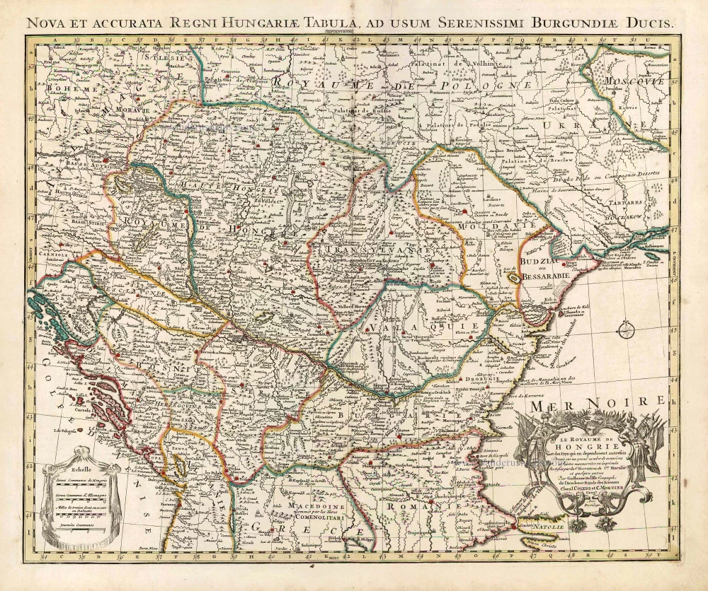
La Hongrie, Suivant les Nouvelles Observations de Mess.rs de l'Academie Royale des Sciences,
Item Number: 26043 Authenticity Guarantee
Category: Antique maps > Europe > Central Europe
Hungary, by Pieter van der Aa.
Title: La Hongrie, Suivant les Nouvelles Observations de Mess.rs de l'Academie Royale des Sciences,
Date of the first edition: 1713.
Date of this map: 1713.
Copper engraving, printed on paper.
Size (not including margins): 225 x 285mm (8.86 x 11.22 inches).
Verso: Blank.
Condition: Original body colour, trimmed to neatline and mounted on heavy paper at an early time.
Condition Rating: A+.
From: Nouvel Atlas, très exact et fort commode pour toutes sortes de personnes, Contenant Les Principales cartes géographiques. Leiden, P. Van der Aa, n.d. (1713) (Koeman, Aa7).
Van der Aa maps are rarely found in original colouring.
Pieter van der Aa (Leiden, 1659-1733)
Pieter van der Aa was already in 1682 owner of a bookshop and auction house. During his life, he has published an enormous amount of printed material.
After 1700, van der Aa increasingly specialised in books on geography and travel.
He published composite atlases, a series of geographical descriptions of European countries, and some very spectacular works. Between 1706 and 1708 he published the Naauweurige versameling der gedenkwaardigste zee- en land-reysen, in 28 volumes.
Many of Van der Aa’s publications are richly illustrated with maps and plates. He took over many copperplates and prints from other publishers such as Carel Allard and Frederik De Wit. The composite atlases that appeared from his workshop contain a curious mixture of his own material, copies of maps from other publishers, and reprints made from old copper plates, now with his own imprint.
The Galérie agréable du monde, was completed in 1729, and comprised 66 parts, bound in 27 volumes. Van der Aa presented it as a good investment; after publication, the antiquarian value of the work would double, the more so since it was printed in a limited edition of only one hundred copies.
Related items

Dotis Ungaris Thata c. 1625
Tata (Hungary) by Braun G. & Hogenberg F.
[Item number: 16381]
Le Royaume de Hongrie et des Pays qui en dependoient autrefois. 1730
Balkans by Guillaume Delisle - Covens & Mortier
[Item number: 25910]

Totius Regni Hungariae, Maximaeque Partis Danubii Fluminis, una cum adjacentibus et finitimis Regionibus. 1656-80
Hungary & Balkans by Nicolaes Visscher I.
[Item number: 28595]

Regnum Hungariae in omnes suos Comitatus. 1683-1696
Hungaria by Nicolaas Visscher II.
[Item number: 29614]

Hungariae Descriptio, Wolfgango Lazio Auct. 1584
Hungary by Abraham Ortelius.
[Item number: 30026]

Danubius, Fluvius Europae Maximus, a Fontibus ad Ostia, Cum omnibus Fluminibus, ab utroque latere, in illum defluentibus. 1643
Danube River by Willem Blaeu.
[Item number: 30307]

Hungaria Regnum. 1653
Hungary by Johannes Janssonius.
[Item number: 30410]

Das Königreich Ungarn nebst den angraentzenden Kaeyserlichen Laendern c. 1745.
Hungary by J.G. Schreiber.
[Item number: 31109]

Schombock. c. 1690
Zsambek (Hungary) by J. Peeters.
[Item number: 31387]

Hungaria 1618
Hungary by Petrus Bertius, published by Jodocus Hondius II.
[Item number: 31647]

Il Regno di Ungheria 1779-1785
Hungary, by Antonio Zatta.
[Item number: 32169]

Rare first state.
Regnorum Hungariae Dalmatiae, Croatiae, Sclavoniae, Bosniae, Serviae et Principatus Transylvaniae c. 1720
Hungary, by J.B. Homann.
[Item number: 32407]

Scarce
Novissima et Accuratissima Totius Hungariae Tabula. c. 1680
Hungary by Pierre Du Val, published by Justus Danckerts.
[Item number: 32510]

Tabu. Moderna Hungariae, Poloniae, Russiae, et Valachiae. (title from verso) 1525
Eastern Europe, by Lorenz Fries.
[Item number: 32716]

Il Regno d'Ungaria Transilvania, Schivonia, Bosnia, Croatia, Dalmatia; 1687
Western Balkans and Central Europe, by Guillaume Sanson, published by Giovanni de Rossi.
[Item number: 32954]

With interesting text in the margins
Hungaria Regnum. c. 1610-1650
Hungary, by Willem & Joan Blaeu.
[Item number: 33031]