
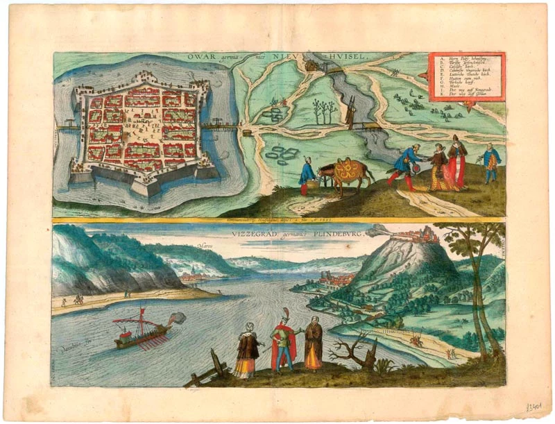
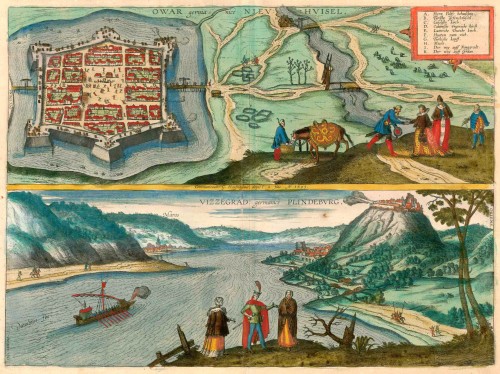
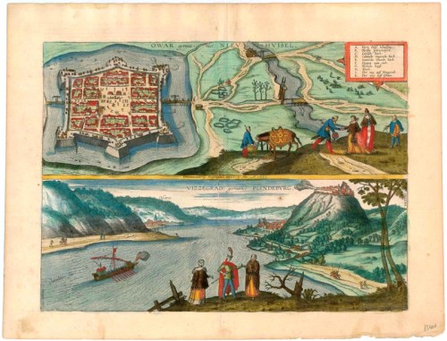
Old, antique map of Nové Zámky (Slovakia) and Visegrád (Hungary) by G. Hoefnagel - Braun & Hogenberg 1596-1640


Braun G. & Hogenberg F. and the Civitates Orbis Terrarum.
The Civitates Orbis Terrarum, also known as the 'Braun & Hogenberg', is a six-volume town atlas and the most excellent book of town views and plans ever published: 363 engravings, sometimes beautifully coloured. It was one of the best-selling works in the last quarter of the 16th century. Georg Braun, a skilled writer, wrote the text accompanying the plans and views on the verso. Many plates were engraved after the original drawings of a professional artist, Joris Hoefnagel (1542-1600). The first volume was published in Latin in 1572 and the sixth in 1617. Frans Hogenberg, a talented engraver, created the tables for volumes I through IV, and Simon van den Neuwel made those for volumes V and VI. Other contributors were cartographers Daniel Freese and Heinrich Rantzau, who provided valuable geographical information. Works by Jacob van Deventer, Sebastian Münster, and Johannes Stumpf were also used as references. Translations appeared in German and French, making the atlas accessible to a broader audience.
Since its original publication of volume 1 in 1572, the Civitates Orbis Terrarum has left an indelible mark on the history of cartography. Seven more editions followed the first volume in 1575, 1577, 1582, 1588, 1593, 1599, and 1612. Vol.2, initially released in 1575, saw subsequent editions in 1597 and 1612. The subsequent volumes, each a treasure trove of historical insights, graced the world in 1581, 1588, 1593, 1599, and 1606. The German translation of the first volume, a testament to its widespread appeal, debuted in 1574, followed by the French edition in 1575.
Several printers were involved: Theodor Graminaeus, Heinrich von Aich, Gottfried von Kempen, Johannis Sinniger, Bertram Buchholtz, and Peter von Brachel, all of whom worked in Cologne.
Georg Braun (1541-1622)
Georg Braun, the author of the text accompanying the plans and views in the Civitates Orbis Terrarum, was born in Cologne in 1541. After his studies in Cologne, he entered the Jesuit Order as a novice, indicating his commitment to learning and intellectual pursuits. In 1561, he obtained his bachelor's degree; in 1562, he received his Magister Artium, further demonstrating his academic achievements. Although he left the Jesuit Order, he continued his studies in theology, gaining a licentiate in theology. His theological background likely influenced the content and tone of the text in the Civitates Orbis Terrarum, adding a unique perspective to the work.
Frans Hogenberg (1535-1590)
Frans Hogenberg was a Flemish and German painter, engraver, and mapmaker. He was born in Mechelen as the son of Nicolaas Hogenberg.
By the end of the 1560s, Frans Hogenberg was employed upon Abraham Ortelius's Theatrum Orbis Terrarum, published in 1570; he is named an engraver of numerous maps. In 1568, he was banned from Antwerp by the Duke of Alva and travelled to London, where he stayed a few years before emigrating to Cologne. He immediately embarked on his two most important works, the Civitates, published in 1572 and the Geschichtsblätter, which appeared in several series from 1569 until about 1587.
Thanks to large-scale projects like the Geschichtsblätter and the Civitates, Hogenberg's social circumstances improved with each passing year. He died as a wealthy man in Cologne in 1590.
Owar Germanice Nieuhuisel [on sheet with] Vizzegrad, Germanice Plindeburg
Item Number: 23401 Authenticity Guarantee
Category: Antique maps > Europe > Central Europe
Bird's-eye views of Nové Zámky (Slovakia) and Visegrád (Hungary) by G. Hoefnagel and son, 1595.
NOVÉ ZÁMKY (ÉRSEK-ÚJVÁR)
CAPTION: Owar, in German Neuhäusel.
COMMENTARY BY BRAUN: "Owar is the name in Hungarian of a castle, called Neuhäusel in German, that lies in Upper Hungary and which is securely fortified by six bastions of the finest construction [...] and is occupied by a detachment of soldiers for the freedom and protection of the neighbouring town. The surrounding moat is supplied with the necessary water by a flowing stream. On the marketplace stands a wooden house in which Turkish captives are held until they have paid their ransom or have been exchanged for other Christian captives."
The fortress of Nové Zámky on the River Nitra is seen in a bird's-eye view. The six-bastioned complex, of which few traces now survive, was built largely from 1573 to 1581 as a stronghold against the Ottomans and withstood ten sieges before finally falling to the Turks in 1663. The detailed military staffage - cannon, soldiers, the heads of the enemy speared on trees (G) - brings the castle's history to life. Despite its small size, three churches were erected within the fortress bounds during the 16th century: one Catholic (C), one German Lutheran (E) and one Hungarian Calvinist (D). The fortress remained in Turkish hands for some 20 years before being reconquered by the Austrians in 1685. In 1692 it was granted its charter by the archbishop of Esztergom. In the 18th century its fortifications were razed. Part of Hungary until 1918, Nové Zámky today belongs to Slovakia.
VISEGRÁD
CAPTION: Vizzegrad, in German Plintenburg.
COMMENTARY BY BRAUN: "Plintenburg is an old castle on a high mountain on the right-hand side of the Danube, well fortified and well equipped with the necessary munitions. At the foot of the mountain, directly beside the Danube, lies a small town that was razed and burned by the Turks. The Hungarian king had often stayed there in the past on account of its healthy air. Opposite lies the little town of Maros, where the Christians live by making tribute payments. It has a large church with a tall tower in which the Catholic religion is expounded and preached."
The small town of Visegrád, shown here in a view from the southwest, lies north of Budapest. Perched high above the settlement, which lies at the foot of Visegrád Hill, is the fortress of the Hungarian kings. The town of Nagymaros (Maros) appears on the opposite, left bank of the river. In former times the limes - the frontier of the Roman Empire, guarded by forts - ran along the right bank of the Danube. Slavs settled on the ruins of one such fort, and in the Middle Ages the Árpád and Angevin kings built a new castle nearby. This was lavishly renovated in the second half of the 15th century under Mathias Corvinus and his wife Beatrix of Aragon. The settlement was occupied for over a century (1544-1685) by the Turks, who left it decimated after their withdrawal. The remains of the once magnificent complex confirm that Visegrád was an important royal fortress. (Taschen)
Copper engraving
Size: 33 x 45.5cm (12.9 x 17.7 inches)
Verso text: Latin
Condition: Excellent, superb old colour.
Condition Rating: A+
References: Van der Krogt 4, 3120; Taschen, Braun and Hogenberg, p.412.
From: Civitates Orbis Terrarum, ... Part 5. Köln, 1598.
Braun G. & Hogenberg F. and the Civitates Orbis Terrarum.
The Civitates Orbis Terrarum, also known as the 'Braun & Hogenberg', is a six-volume town atlas and the most excellent book of town views and plans ever published: 363 engravings, sometimes beautifully coloured. It was one of the best-selling works in the last quarter of the 16th century. Georg Braun, a skilled writer, wrote the text accompanying the plans and views on the verso. Many plates were engraved after the original drawings of a professional artist, Joris Hoefnagel (1542-1600). The first volume was published in Latin in 1572 and the sixth in 1617. Frans Hogenberg, a talented engraver, created the tables for volumes I through IV, and Simon van den Neuwel made those for volumes V and VI. Other contributors were cartographers Daniel Freese and Heinrich Rantzau, who provided valuable geographical information. Works by Jacob van Deventer, Sebastian Münster, and Johannes Stumpf were also used as references. Translations appeared in German and French, making the atlas accessible to a broader audience.
Since its original publication of volume 1 in 1572, the Civitates Orbis Terrarum has left an indelible mark on the history of cartography. Seven more editions followed the first volume in 1575, 1577, 1582, 1588, 1593, 1599, and 1612. Vol.2, initially released in 1575, saw subsequent editions in 1597 and 1612. The subsequent volumes, each a treasure trove of historical insights, graced the world in 1581, 1588, 1593, 1599, and 1606. The German translation of the first volume, a testament to its widespread appeal, debuted in 1574, followed by the French edition in 1575.
Several printers were involved: Theodor Graminaeus, Heinrich von Aich, Gottfried von Kempen, Johannis Sinniger, Bertram Buchholtz, and Peter von Brachel, all of whom worked in Cologne.
Georg Braun (1541-1622)
Georg Braun, the author of the text accompanying the plans and views in the Civitates Orbis Terrarum, was born in Cologne in 1541. After his studies in Cologne, he entered the Jesuit Order as a novice, indicating his commitment to learning and intellectual pursuits. In 1561, he obtained his bachelor's degree; in 1562, he received his Magister Artium, further demonstrating his academic achievements. Although he left the Jesuit Order, he continued his studies in theology, gaining a licentiate in theology. His theological background likely influenced the content and tone of the text in the Civitates Orbis Terrarum, adding a unique perspective to the work.
Frans Hogenberg (1535-1590)
Frans Hogenberg was a Flemish and German painter, engraver, and mapmaker. He was born in Mechelen as the son of Nicolaas Hogenberg.
By the end of the 1560s, Frans Hogenberg was employed upon Abraham Ortelius's Theatrum Orbis Terrarum, published in 1570; he is named an engraver of numerous maps. In 1568, he was banned from Antwerp by the Duke of Alva and travelled to London, where he stayed a few years before emigrating to Cologne. He immediately embarked on his two most important works, the Civitates, published in 1572 and the Geschichtsblätter, which appeared in several series from 1569 until about 1587.
Thanks to large-scale projects like the Geschichtsblätter and the Civitates, Hogenberg's social circumstances improved with each passing year. He died as a wealthy man in Cologne in 1590.
