
Old antique plan of Slovakia - Velky Saris by Braun & Hogenberg c. 1625
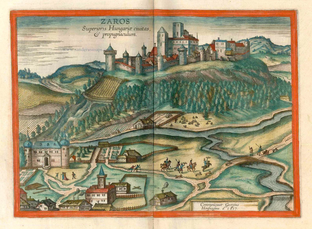


CAPTION: Sárospatak, city and fortress in Upper Hungary.
Signed and dated bottom right: Procured by Georg Hoefnagel, in the year 1617.
COMMENTARY BY BRAUN (on verso): "This fortress, blessed by art and by nature, lies in the northern part of Upper Hungary. It is on a high hill, which is full of trees and bushes on the one side and fruitful vines on the other. Below the hill flows a stream that drives several mills. On the level ground on this side of the river there are many fine estates and charming gardens, as well as other farm houses, so that it has the appearance of a suburb. But the other side of the river is full of hills and mountains on which good vines grow."
The castle of Sárospatak above the banks of the Bodrog in what is today northeast Hungary is shown from the southwest from a slightly elevated position. The outskirts of the town can be seen on this side of the river. The scenery is enlivened by the depiction of a small hunting party, indicating that this is a lordly estate. In the 11th century Patak on the Bodrog was a residence of the royal House of Arpád and quickly grew from the 12th century onwards with the settling here of Italian and French merchants. The town became a free city in 1429 and passed to the Rákóczi princes in the early 17th century. They turned the castle into their residence. Under them the city, which had been Calvinist since the Reformation, became a centre of humanist education and of the Hungarian struggle against the Habsburgs. The castle was destroyed by the Austrians at the beginning of the 18th century, but was rebuilt soon afterwards in the Baroque style. Today it is considered to be one of the finest in Hungary. (Taschen)
Braun G. & Hogenberg F. and the Civitates Orbis Terrarum.
The Civitates Orbis Terrarum, also known as the 'Braun & Hogenberg', is a six-volume town atlas and the most excellent book of town views and plans ever published: 363 engravings, sometimes beautifully coloured. It was one of the best-selling works in the last quarter of the 16th century. Georg Braun, a skilled writer, wrote the text accompanying the plans and views on the verso. Many plates were engraved after the original drawings of a professional artist, Joris Hoefnagel (1542-1600). The first volume was published in Latin in 1572 and the sixth in 1617. Frans Hogenberg, a talented engraver, created the tables for volumes I through IV, and Simon van den Neuwel made those for volumes V and VI. Other contributors were cartographers Daniel Freese and Heinrich Rantzau, who provided valuable geographical information. Works by Jacob van Deventer, Sebastian Münster, and Johannes Stumpf were also used as references. Translations appeared in German and French, making the atlas accessible to a broader audience.
Since its original publication of volume 1 in 1572, the Civitates Orbis Terrarum has left an indelible mark on the history of cartography. Seven more editions followed the first volume in 1575, 1577, 1582, 1588, 1593, 1599, and 1612. Vol.2, initially released in 1575, saw subsequent editions in 1597 and 1612. The subsequent volumes, each a treasure trove of historical insights, graced the world in 1581, 1588, 1593, 1599, and 1606. The German translation of the first volume, a testament to its widespread appeal, debuted in 1574, followed by the French edition in 1575.
Several printers were involved: Theodor Graminaeus, Heinrich von Aich, Gottfried von Kempen, Johannis Sinniger, Bertram Buchholtz, and Peter von Brachel, all of whom worked in Cologne.
Georg Braun (1541-1622)
Georg Braun, the author of the text accompanying the plans and views in the Civitates Orbis Terrarum, was born in Cologne in 1541. After his studies in Cologne, he entered the Jesuit Order as a novice, indicating his commitment to learning and intellectual pursuits. In 1561, he obtained his bachelor's degree; in 1562, he received his Magister Artium, further demonstrating his academic achievements. Although he left the Jesuit Order, he continued his studies in theology, gaining a licentiate in theology. His theological background likely influenced the content and tone of the text in the Civitates Orbis Terrarum, adding a unique perspective to the work.
Frans Hogenberg (1535-1590)
Frans Hogenberg was a Flemish and German painter, engraver, and mapmaker. He was born in Mechelen as the son of Nicolaas Hogenberg.
By the end of the 1560s, Frans Hogenberg was employed upon Abraham Ortelius's Theatrum Orbis Terrarum, published in 1570; he is named an engraver of numerous maps. In 1568, he was banned from Antwerp by the Duke of Alva and travelled to London, where he stayed a few years before emigrating to Cologne. He immediately embarked on his two most important works, the Civitates, published in 1572 and the Geschichtsblätter, which appeared in several series from 1569 until about 1587.
Thanks to large-scale projects like the Geschichtsblätter and the Civitates, Hogenberg's social circumstances improved with each passing year. He died as a wealthy man in Cologne in 1590.
Zaros Superioris Hungariae Civitas, & propugnaculum.
Item Number: 16455 Authenticity Guarantee
Category: Antique maps > Europe > Central Europe
Antique map - Bird's-eye view of Velky Saris (today Slovakia) by Braun and Hogenberg, after G. Hoefnagel. 1617.
CAPTION: Sárospatak, city and fortress in Upper Hungary.
Signed and dated bottom right: Procured by Georg Hoefnagel, in the year 1617.
COMMENTARY BY BRAUN (on verso): "This fortress, blessed by art and by nature, lies in the northern part of Upper Hungary. It is on a high hill, which is full of trees and bushes on the one side and fruitful vines on the other. Below the hill flows a stream that drives several mills. On the level ground on this side of the river there are many fine estates and charming gardens, as well as other farmhouses, so that it has the appearance of a suburb. But the other side of the river is full of hills and mountains on which good vines grow."
The castle of Sárospatak above the banks of the Bodrog in what is today northeast Hungary is shown from the southwest from a slightly elevated position. The outskirts of the town can be seen on this side of the river. The scenery is enlivened by the depiction of a small hunting party, indicating that this is a lordly estate. In the 11th century Patak on the Bodrog was a residence of the royal House of Arpád and quickly grew from the 12th century onwards with the settling here of Italian and French merchants. The town became a free city in 1429 and passed to the Rákóczi princes in the early 17th century. They turned the castle into their residence. Under them the city, which had been Calvinist since the Reformation, became a centre of humanist education and of the Hungarian struggle against the Habsburgs. The castle was destroyed by the Austrians at the beginning of the 18th century, but was rebuilt soon afterwards in the Baroque style. Today it is considered to be one of the finest in Hungary. (Taschen)
Date of the first edition: 1617
Date of this map: c. 1625
Copper engraving
Size: 32 x 44cm (12.5 x 17.2 inches)
Verso text: French
Condition: Contemporary coloured, excellent.
Condition Rating: A
References: Van der Krogt 4, 3872; Fauser, 12560; Taschen, Braun and Hogenberg, p.480.
From: Théatre des Principales Villes de tout l'Univers Vol. VI. c. 1625. (Van der Krogt 4, 41:3.6)
CAPTION: Sárospatak, city and fortress in Upper Hungary.
Signed and dated bottom right: Procured by Georg Hoefnagel, in the year 1617.
COMMENTARY BY BRAUN (on verso): "This fortress, blessed by art and by nature, lies in the northern part of Upper Hungary. It is on a high hill, which is full of trees and bushes on the one side and fruitful vines on the other. Below the hill flows a stream that drives several mills. On the level ground on this side of the river there are many fine estates and charming gardens, as well as other farm houses, so that it has the appearance of a suburb. But the other side of the river is full of hills and mountains on which good vines grow."
The castle of Sárospatak above the banks of the Bodrog in what is today northeast Hungary is shown from the southwest from a slightly elevated position. The outskirts of the town can be seen on this side of the river. The scenery is enlivened by the depiction of a small hunting party, indicating that this is a lordly estate. In the 11th century Patak on the Bodrog was a residence of the royal House of Arpád and quickly grew from the 12th century onwards with the settling here of Italian and French merchants. The town became a free city in 1429 and passed to the Rákóczi princes in the early 17th century. They turned the castle into their residence. Under them the city, which had been Calvinist since the Reformation, became a centre of humanist education and of the Hungarian struggle against the Habsburgs. The castle was destroyed by the Austrians at the beginning of the 18th century, but was rebuilt soon afterwards in the Baroque style. Today it is considered to be one of the finest in Hungary. (Taschen)
Braun G. & Hogenberg F. and the Civitates Orbis Terrarum.
The Civitates Orbis Terrarum, also known as the 'Braun & Hogenberg', is a six-volume town atlas and the most excellent book of town views and plans ever published: 363 engravings, sometimes beautifully coloured. It was one of the best-selling works in the last quarter of the 16th century. Georg Braun, a skilled writer, wrote the text accompanying the plans and views on the verso. Many plates were engraved after the original drawings of a professional artist, Joris Hoefnagel (1542-1600). The first volume was published in Latin in 1572 and the sixth in 1617. Frans Hogenberg, a talented engraver, created the tables for volumes I through IV, and Simon van den Neuwel made those for volumes V and VI. Other contributors were cartographers Daniel Freese and Heinrich Rantzau, who provided valuable geographical information. Works by Jacob van Deventer, Sebastian Münster, and Johannes Stumpf were also used as references. Translations appeared in German and French, making the atlas accessible to a broader audience.
Since its original publication of volume 1 in 1572, the Civitates Orbis Terrarum has left an indelible mark on the history of cartography. Seven more editions followed the first volume in 1575, 1577, 1582, 1588, 1593, 1599, and 1612. Vol.2, initially released in 1575, saw subsequent editions in 1597 and 1612. The subsequent volumes, each a treasure trove of historical insights, graced the world in 1581, 1588, 1593, 1599, and 1606. The German translation of the first volume, a testament to its widespread appeal, debuted in 1574, followed by the French edition in 1575.
Several printers were involved: Theodor Graminaeus, Heinrich von Aich, Gottfried von Kempen, Johannis Sinniger, Bertram Buchholtz, and Peter von Brachel, all of whom worked in Cologne.
Georg Braun (1541-1622)
Georg Braun, the author of the text accompanying the plans and views in the Civitates Orbis Terrarum, was born in Cologne in 1541. After his studies in Cologne, he entered the Jesuit Order as a novice, indicating his commitment to learning and intellectual pursuits. In 1561, he obtained his bachelor's degree; in 1562, he received his Magister Artium, further demonstrating his academic achievements. Although he left the Jesuit Order, he continued his studies in theology, gaining a licentiate in theology. His theological background likely influenced the content and tone of the text in the Civitates Orbis Terrarum, adding a unique perspective to the work.
Frans Hogenberg (1535-1590)
Frans Hogenberg was a Flemish and German painter, engraver, and mapmaker. He was born in Mechelen as the son of Nicolaas Hogenberg.
By the end of the 1560s, Frans Hogenberg was employed upon Abraham Ortelius's Theatrum Orbis Terrarum, published in 1570; he is named an engraver of numerous maps. In 1568, he was banned from Antwerp by the Duke of Alva and travelled to London, where he stayed a few years before emigrating to Cologne. He immediately embarked on his two most important works, the Civitates, published in 1572 and the Geschichtsblätter, which appeared in several series from 1569 until about 1587.
Thanks to large-scale projects like the Geschichtsblätter and the Civitates, Hogenberg's social circumstances improved with each passing year. He died as a wealthy man in Cologne in 1590.