
Prague - Cheb by Braun & Hogenberg 1635
The item displayed on this page has been sold. However, we have a similar map in stock:
Prague - Cheb by Braun & Hogenberg 1582
Praga, Bohemiae Metropolis Accuratissime Expressa...
[Item number: 25484]
![Praga, Bohemiae Metropolis Accuratissime Expressa [on sheet with] Egra, Urbs a Fluvio ...](https://sanderusmaps.com/assets/RESIZED/thumb_m25484.jpg)
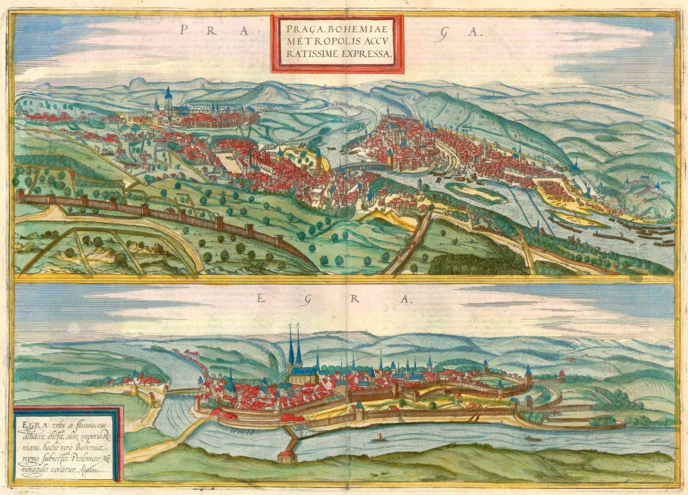


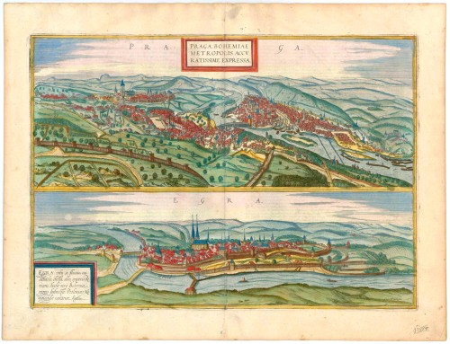
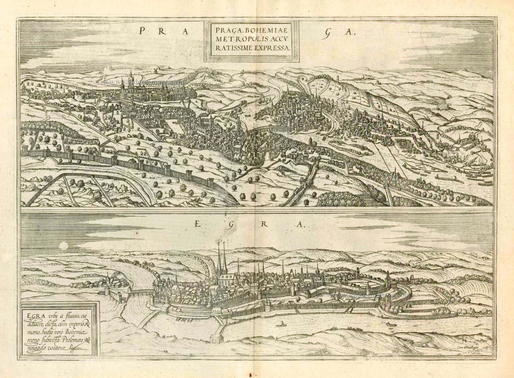
PRAGUE (PRAHA)
CARTOUCHE: Prague, the capital of Bohemia, is most accurately portrayed.
COMMENTARY BY BRAUN: "Bohemia borders on Hungary to the east, Bavaria to the south, the Nordgau to the west. [...] The Elbe flows through the middle of this land but is eclipsed by the Moldau [Vltava], which flows through the noblest capital of the whole kingdom, Prague. Prague is a worthy royal and episcopal see, surely no less estimable than Florence. Prague is divided into three towns: Lesser Prague, Old Prague and New Prague. There is also a Prague university founded by the Bohemian king Charles IV, with a valuable library and magnificent university buildings."
The splendid first illustration of Prague shows the royal city from the southeast, in its natural setting in the Vltava Valley, which has cut its way deeply between the surrounding hills. On the left lies the all-dominating Hradcany castle complex from the 9th/10th centuries, beneath which is the Lesser Quarter (Malá Strana), linked to the Old Town (Staré Mesto) by the magnificent Charles Bridge with its massive towers at each end. In the Old Town, the Gothic Teyn church with its twin towers can be recognised near the town hall. Above the Old Town and beneath the New Town (Nové Mesto) lies the old Jewish Quarter (Josefov). From the second half of the 14th century onwards, under Emperor Charles IV and his son Wenceslas IV, Prague was the capital of the Holy Roman Empire. Prague University, founded in 1348, was the first German-speaking university. By around 1600, Prague had 60,000 inhabitants, although its various districts were officially combined into a single metropolis as late as 1784.
CHEB
CARTOUCHE: Eger is named after the river on which it lies; it was formerly subject to the Roman Empire, today to the Kingdom of Bohemia; Ptolemy called it Monosgada.
COMMENTARY BY BRAUN: "Cheb, situated on very fertile soil between mountains and forests, is not the least significant town in Bohemia. It lies on a large river of the same name as the town and is navigable southward. The site also possesses a magnificent castle and a praiseworthy church of St Nicholas with two tall towers and other churches and monasteries."
The view from a cavalier perspective on the opposite bank of the River Ohre shows the well-fortified medieval town, with its all-dominating 12th-century imperial palace and the Gothic hall church of SS Nicholas and Elizabeth. Cheb was initially built as an imperial palace by Emperor Barbarossa and, in 1277, became an imperial city. Two critical treaties were negotiated here: the Golden Bull of Eger of 1213, in which King Frederick II granted the German bishops the freedom to elect their own prelates, and the 1459 Peace of Eger, which determined the border between Bohemia and the Electorate of Saxony. (Taschen)
The view is made after a woodcut in Münster's Cosmographia, 1550.
Praga, Bohemiae Metropolis Accuratissime Expressa [on sheet with] Egra, Urbs a Fluvio ...
Item Number: 23229 Authenticity Guarantee
Category: Antique maps > Europe > Central Europe
Prague - Cheb by Braun & Hogenberg.
Title: Praga, Bohemiae Metropolis Accuratissime Expressa [on sheet with] Egra, Urbs a Fluvio ...
Date of the first edition: 1572.
Date of this map: 1635.
Copper engraving, printed on paper.
Image size: 335 x 475mm (13¼ x 18¾ inches).
Sheet size: 410 x 540mm (16¼ x 21¼ inches).
Verso: Latin text.
Condition: Excellent, superb old colour.
Condition Rating: A+.
From: Civitates Orbis Terrarum, Liber Primus. Köln, Petrus von Brachel, 1635 (Van der Krogt 4, 41:1.1)
PRAGUE (PRAHA)
CARTOUCHE: Prague, the capital of Bohemia, is most accurately portrayed.
COMMENTARY BY BRAUN: "Bohemia borders on Hungary to the east, Bavaria to the south, the Nordgau to the west. [...] The Elbe flows through the middle of this land but is eclipsed by the Moldau [Vltava], which flows through the noblest capital of the whole kingdom, Prague. Prague is a worthy royal and episcopal see, surely no less estimable than Florence. Prague is divided into three towns: Lesser Prague, Old Prague and New Prague. There is also a Prague university founded by the Bohemian king Charles IV, with a valuable library and magnificent university buildings."
The splendid first illustration of Prague shows the royal city from the southeast, in its natural setting in the Vltava Valley, which has cut its way deeply between the surrounding hills. On the left lies the all-dominating Hradcany castle complex from the 9th/10th centuries, beneath which is the Lesser Quarter (Malá Strana), linked to the Old Town (Staré Mesto) by the magnificent Charles Bridge with its massive towers at each end. In the Old Town, the Gothic Teyn church with its twin towers can be recognised near the town hall. Above the Old Town and beneath the New Town (Nové Mesto) lies the old Jewish Quarter (Josefov). From the second half of the 14th century onwards, under Emperor Charles IV and his son Wenceslas IV, Prague was the capital of the Holy Roman Empire. Prague University, founded in 1348, was the first German-speaking university. By around 1600, Prague had 60,000 inhabitants, although its various districts were officially combined into a single metropolis as late as 1784.
CHEB
CARTOUCHE: Eger is named after the river on which it lies; it was formerly subject to the Roman Empire, today to the Kingdom of Bohemia; Ptolemy called it Monosgada.
COMMENTARY BY BRAUN: "Cheb, situated on very fertile soil between mountains and forests, is not the least significant town in Bohemia. It lies on a large river of the same name as the town and is navigable southward. The site also possesses a magnificent castle and a praiseworthy church of St Nicholas with two tall towers and other churches and monasteries."
The view from a cavalier perspective on the opposite bank of the River Ohre shows the well-fortified medieval town, with its all-dominating 12th-century imperial palace and the Gothic hall church of SS Nicholas and Elizabeth. Cheb was initially built as an imperial palace by Emperor Barbarossa and, in 1277, became an imperial city. Two critical treaties were negotiated here: the Golden Bull of Eger of 1213, in which King Frederick II granted the German bishops the freedom to elect their own prelates, and the 1459 Peace of Eger, which determined the border between Bohemia and the Electorate of Saxony. (Taschen)
The view is made after a woodcut in Münster's Cosmographia, 1550.
Related items
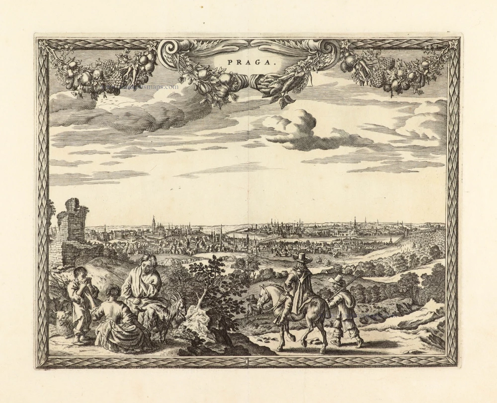
Praga, Bohemiae Metropolis Accuratissime Expressa [on sheet with] Egra, Urbs a Fluvio ... 1599
Prague (Praha) and Cheb in Bohemia, by Georg Braun and Frans Hogenberg.
[Item number: 23924]
Unrecorded variant of Allard's view of Prague (Praha)
Praga. 1673
View of Prague (Praha) by Carel Allard.
[Item number: 30557]