
Antique map - bird's-eye view of Brno by Braun and Hogenberg c. 1625


Engraved after a woodcut by Johann Willenberger, 1593..
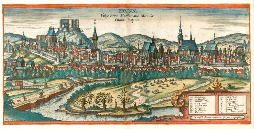
TRANSLATION OF CAPTION: Brunn, in the vernacular Brno, eminent city in the Margravate of Moravia.
COMMENTARY BY BRAUN: "Brno (in Latin Bruna, in Bohemian Brno) is the most distinguished city in Moravia after the episcopal see of Olomouc and has more beautiful, grand and richly decorated buildings and houses than the other towns. It is impossible to say how old this city is, but we know that it cannot be new for many reasons, in particular the castle, which resembles the old Fanconian style of architecture. Today the provincial diets are normally held here. Recently the Moravian Estates acknowledged and paid homage to His Serene Highness Archduke Ferdinand here after he had been elected and crowned king of Bohemia."
Brno is seen from the southeast, from an only slightly elevated viewpoint on the far side of the River Svratka. The city wall is fortified with an extraordinary number of towers, behind which can be seen many churches. Dominant on the right is the spire of St James's church (N), which dates from the 14th to the 16th century. On the left the castle stands high above the city, on top of the Spilberk Hill. It was founded in the 13th century, and was the residence of the Margraves of Moravia (F) from the 14th century onwards. The cathedral of SS Peter and Paul, with its remarkable high saddleback roof, can be seen to the left of this, and to the right the tower of the Gothic town hall (H). The city is located in a favourable position, at the foot of the Spilberk Hill and at the confluence of the Svratka and the Svitava. It was first recorded in a document in the late 11th century. In the 12th/13th centuries Germans and Walloons settled here. In 1243 Brno was granted a municipal charter and a number of special privileges. In 1642 Brno replaced Olomouc as the capital of Moravia, and today it is the second-largest city in the Czech Republic after Prague. (Taschen)
Braun G. & Hogenberg F. and the Civitates Orbis Terrarum.
The Civitates Orbis Terrarum, also known as the 'Braun & Hogenberg', is a six-volume town atlas and the most excellent book of town views and plans ever published: 363 engravings, sometimes beautifully coloured. It was one of the best-selling works in the last quarter of the 16th century. Georg Braun, a skilled writer, wrote the text accompanying the plans and views on the verso. Many plates were engraved after the original drawings of a professional artist, Joris Hoefnagel (1542-1600). The first volume was published in Latin in 1572 and the sixth in 1617. Frans Hogenberg, a talented engraver, created the tables for volumes I through IV, and Simon van den Neuwel made those for volumes V and VI. Other contributors were cartographers Daniel Freese and Heinrich Rantzau, who provided valuable geographical information. Works by Jacob van Deventer, Sebastian Münster, and Johannes Stumpf were also used as references. Translations appeared in German and French, making the atlas accessible to a broader audience.
Since its original publication of volume 1 in 1572, the Civitates Orbis Terrarum has left an indelible mark on the history of cartography. Seven more editions followed the first volume in 1575, 1577, 1582, 1588, 1593, 1599, and 1612. Vol.2, initially released in 1575, saw subsequent editions in 1597 and 1612. The subsequent volumes, each a treasure trove of historical insights, graced the world in 1581, 1588, 1593, 1599, and 1606. The German translation of the first volume, a testament to its widespread appeal, debuted in 1574, followed by the French edition in 1575.
Several printers were involved: Theodor Graminaeus, Heinrich von Aich, Gottfried von Kempen, Johannis Sinniger, Bertram Buchholtz, and Peter von Brachel, all of whom worked in Cologne.
Georg Braun (1541-1622)
Georg Braun, the author of the text accompanying the plans and views in the Civitates Orbis Terrarum, was born in Cologne in 1541. After his studies in Cologne, he entered the Jesuit Order as a novice, indicating his commitment to learning and intellectual pursuits. In 1561, he obtained his bachelor's degree; in 1562, he received his Magister Artium, further demonstrating his academic achievements. Although he left the Jesuit Order, he continued his studies in theology, gaining a licentiate in theology. His theological background likely influenced the content and tone of the text in the Civitates Orbis Terrarum, adding a unique perspective to the work.
Frans Hogenberg (1535-1590)
Frans Hogenberg was a Flemish and German painter, engraver, and mapmaker. He was born in Mechelen as the son of Nicolaas Hogenberg.
By the end of the 1560s, Frans Hogenberg was employed upon Abraham Ortelius's Theatrum Orbis Terrarum, published in 1570; he is named an engraver of numerous maps. In 1568, he was banned from Antwerp by the Duke of Alva and travelled to London, where he stayed a few years before emigrating to Cologne. He immediately embarked on his two most important works, the Civitates, published in 1572 and the Geschichtsblätter, which appeared in several series from 1569 until about 1587.
Thanks to large-scale projects like the Geschichtsblätter and the Civitates, Hogenberg's social circumstances improved with each passing year. He died as a wealthy man in Cologne in 1590.
Brunn Vulgo Brinn Marchionatus Moraviae Civitas insignis.
Item Number: 16443 Authenticity Guarantee
Category: Antique maps > Europe > Eastern Europe
Antique map - bird's-eye view of Brno by Braun and Hogenberg, engraved after a woodcut by Johann Willenberger, 1593..
TRANSLATION OF CAPTION: Brunn, in the vernacular Brno, eminent city in the Margravate of Moravia.
COMMENTARY BY BRAUN: "Brno (in Latin Bruna, in Bohemian Brno) is the most distinguished city in Moravia after the episcopal see of Olomouc and has more beautiful, grand and richly decorated buildings and houses than the other towns. It is impossible to say how old this city is, but we know that it cannot be new for many reasons, in particular the castle, which resembles the old Fanconian style of architecture. Today the provincial diets are normally held here. Recently the Moravian Estates acknowledged and paid homage to His Serene Highness Archduke Ferdinand here after he had been elected and crowned king of Bohemia."
Brno is seen from the southeast, from an only slightly elevated viewpoint on the far side of the River Svratka. The city wall is fortified with an extraordinary number of towers, behind which can be seen many churches. Dominant on the right is the spire of St James's church (N), which dates from the 14th to the 16th century. On the left the castle stands high above the city, on top of the Spilberk Hill. It was founded in the 13th century, and was the residence of the Margraves of Moravia (F) from the 14th century onwards. The cathedral of SS Peter and Paul, with its remarkable high saddleback roof, can be seen to the left of this, and to the right the tower of the Gothic town hall (H). The city is located in a favourable position, at the foot of the Spilberk Hill and at the confluence of the Svratka and the Svitava. It was first recorded in a document in the late 11th century. In the 12th/13th centuries Germans and Walloons settled here. In 1243 Brno was granted a municipal charter and a number of special privileges. In 1642 Brno replaced Olomouc as the capital of Moravia, and today it is the second-largest city in the Czech Republic after Prague. (Taschen)
Date of the first edition: 1617
Date of this map: c. 1625
Copper engraving
Size: 28 x 51cm (10.9 x 19.9 inches)
Verso text: French
Condition: Contemporary coloured, excellent.
Condition Rating: A
References: Van der Krogt 4, 653; Taschen, Braun and Hogenberg, p.484.
From: Théatre des Principales Villes de tout l'Univers Vol. VI. c. 1625. (Van der Krogt 4, 41:3.6)
Engraved after a woodcut by Johann Willenberger, 1593..
TRANSLATION OF CAPTION: Brunn, in the vernacular Brno, eminent city in the Margravate of Moravia.
COMMENTARY BY BRAUN: "Brno (in Latin Bruna, in Bohemian Brno) is the most distinguished city in Moravia after the episcopal see of Olomouc and has more beautiful, grand and richly decorated buildings and houses than the other towns. It is impossible to say how old this city is, but we know that it cannot be new for many reasons, in particular the castle, which resembles the old Fanconian style of architecture. Today the provincial diets are normally held here. Recently the Moravian Estates acknowledged and paid homage to His Serene Highness Archduke Ferdinand here after he had been elected and crowned king of Bohemia."
Brno is seen from the southeast, from an only slightly elevated viewpoint on the far side of the River Svratka. The city wall is fortified with an extraordinary number of towers, behind which can be seen many churches. Dominant on the right is the spire of St James's church (N), which dates from the 14th to the 16th century. On the left the castle stands high above the city, on top of the Spilberk Hill. It was founded in the 13th century, and was the residence of the Margraves of Moravia (F) from the 14th century onwards. The cathedral of SS Peter and Paul, with its remarkable high saddleback roof, can be seen to the left of this, and to the right the tower of the Gothic town hall (H). The city is located in a favourable position, at the foot of the Spilberk Hill and at the confluence of the Svratka and the Svitava. It was first recorded in a document in the late 11th century. In the 12th/13th centuries Germans and Walloons settled here. In 1243 Brno was granted a municipal charter and a number of special privileges. In 1642 Brno replaced Olomouc as the capital of Moravia, and today it is the second-largest city in the Czech Republic after Prague. (Taschen)
Braun G. & Hogenberg F. and the Civitates Orbis Terrarum.
The Civitates Orbis Terrarum, also known as the 'Braun & Hogenberg', is a six-volume town atlas and the most excellent book of town views and plans ever published: 363 engravings, sometimes beautifully coloured. It was one of the best-selling works in the last quarter of the 16th century. Georg Braun, a skilled writer, wrote the text accompanying the plans and views on the verso. Many plates were engraved after the original drawings of a professional artist, Joris Hoefnagel (1542-1600). The first volume was published in Latin in 1572 and the sixth in 1617. Frans Hogenberg, a talented engraver, created the tables for volumes I through IV, and Simon van den Neuwel made those for volumes V and VI. Other contributors were cartographers Daniel Freese and Heinrich Rantzau, who provided valuable geographical information. Works by Jacob van Deventer, Sebastian Münster, and Johannes Stumpf were also used as references. Translations appeared in German and French, making the atlas accessible to a broader audience.
Since its original publication of volume 1 in 1572, the Civitates Orbis Terrarum has left an indelible mark on the history of cartography. Seven more editions followed the first volume in 1575, 1577, 1582, 1588, 1593, 1599, and 1612. Vol.2, initially released in 1575, saw subsequent editions in 1597 and 1612. The subsequent volumes, each a treasure trove of historical insights, graced the world in 1581, 1588, 1593, 1599, and 1606. The German translation of the first volume, a testament to its widespread appeal, debuted in 1574, followed by the French edition in 1575.
Several printers were involved: Theodor Graminaeus, Heinrich von Aich, Gottfried von Kempen, Johannis Sinniger, Bertram Buchholtz, and Peter von Brachel, all of whom worked in Cologne.
Georg Braun (1541-1622)
Georg Braun, the author of the text accompanying the plans and views in the Civitates Orbis Terrarum, was born in Cologne in 1541. After his studies in Cologne, he entered the Jesuit Order as a novice, indicating his commitment to learning and intellectual pursuits. In 1561, he obtained his bachelor's degree; in 1562, he received his Magister Artium, further demonstrating his academic achievements. Although he left the Jesuit Order, he continued his studies in theology, gaining a licentiate in theology. His theological background likely influenced the content and tone of the text in the Civitates Orbis Terrarum, adding a unique perspective to the work.
Frans Hogenberg (1535-1590)
Frans Hogenberg was a Flemish and German painter, engraver, and mapmaker. He was born in Mechelen as the son of Nicolaas Hogenberg.
By the end of the 1560s, Frans Hogenberg was employed upon Abraham Ortelius's Theatrum Orbis Terrarum, published in 1570; he is named an engraver of numerous maps. In 1568, he was banned from Antwerp by the Duke of Alva and travelled to London, where he stayed a few years before emigrating to Cologne. He immediately embarked on his two most important works, the Civitates, published in 1572 and the Geschichtsblätter, which appeared in several series from 1569 until about 1587.
Thanks to large-scale projects like the Geschichtsblätter and the Civitates, Hogenberg's social circumstances improved with each passing year. He died as a wealthy man in Cologne in 1590.