
Antique map of Russia - Moscow by Blaeu J. 1649-55

The Blaeus: Willem Janszoon, Cornelis & Joan
Willem Jansz. Blaeu and his son Joan Blaeu are the seventeenth century's most widely known cartographic publishers.
Willem Jansz. (also written Guilielmus Janssonius) = Willem Janszoon Blaeu was born in Uitgeest (Netherlands), near Alkmaar, in 1571. He studied mathematics under Tycho Brahe and learned the theory and practice of astronomical observations and the art of instrument- and globe-making.
In 1596, he came to Amsterdam, where he settled down as a globe-, instrument- and mapmaker. He published his first cartographic work (a globe) in 1599 and probably published his first printed map (a map of the Netherlands) in 1604. He specialised in maritime cartography, published the first edition of the pilot guide Het Licht der Zeevaert in 1608, and was appointed Hydrographer of the V.O.C. (United East India Company) in 1633. After publishing books, wall maps, globes, charts and pilot guides for thirty years, he brought out his first atlas, Atlas Appendix (1630). This was the beginning of the great tradition of atlas-making by the Blaeus.
In 1618, another mapmaker, bookseller and publisher, Johannes Janssonius, established himself in Amsterdam next door to Blaeu's shop. No wonder these two neighbours began accusing each other of copying and stealing their information and became fierce competitors who did not have a good word to say about each other. In about 1621 Willem Jansz. decided to end the confusion between his name and his competitor's and assumed his grandfather's nickname, 'blauwe Willem' ('blue Willem'), as the family name; after that, he called himself Willem Jansz. Blaeu.
Willem Janszoon Blaeu died in 1638, leaving his prospering business to his sons, Cornelis and Joan. We only know that Cornelis's name occurs in the prefaces of books and atlases until c. 1645.
Joan Blaeu, born in Amsterdam in 1596, became a partner in his father's book trade and printing business. 1638, he was appointed his father's successor in the Hydrographic Office of the V.O.C. His efforts culminated in the magnificent Atlas Major and the town books of the Netherlands and Italy – works unsurpassed in history and modern times, giving eternal fame to the name of the Blaeu's.
A fire ruined the business on February 23, 1672, and one year later, Dr. Joan Blaeu died. The fire and the director's passing caused the complete sale of the Blaeu House's stock. Five public auctions dispersed the remaining books, atlases, copperplates, globes, etc., among many other map dealers and publishers in Amsterdam. The majority was acquired by several booksellers acting in partnership.
In the succeeding years, the remaining printing department remained in the hands of the Blaeu family until 1695, when the printing house's inventory was sold at a public auction. That meant the end of the Blaeu family as a printing house of world renown.
Tabula Russiae ex autographo, quod delineandum curavit Foedor filius Tzaris Boris desumta; . . . M.DC.XIIII.
Item Number: 1833 Authenticity Guarantee
Category: Antique maps > Europe > Eastern Europe
Antique map of Russia - Moscow by Blaeu J.
Third state of a map by Hessel Gerritsz.
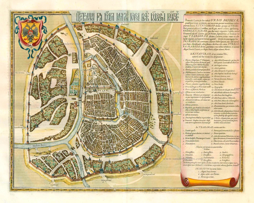
This map includes two insets: a plan of Moscow and a view of Archangel. The plan of Moscow is a reduced version of a Russian plan dating from approx. 1597-1599 and was probably copied by Fyodor Godunov as a school exercise. A note to the reader chiefly describes the fortifications of the city: "Gentle reader, here you see the sections of the walls of the city of Moscow divided into four, or rather the four fortifications of the walls, of which the innermost is called Kitaygorod and is also a city itself. Closest to this is the castle, or rather the palace, surrounded by walls, and called Kremlenagrad, which is encircled by two walls of stone, to which a few other materials have been added. The city, which continues to the east, north and west, is called Tsargorod, the city of the tsar: surrounded by walls of white stone but with earth added. The surrounding area outside is called Skorodum, with walls of wood but no earth; the part of it is situated on the other side of the Moskva River, however, is called Strelzka Slaboda, and soldiers live in the houses there, and the guard of the great lord the tsar and the grand duke, and other children of Mars." The walls of Kitaygorod were built between 1534 and 1538. The nine-kilometer wall with 28 towers that surrounds Tsargrad, or Belgorod (white city), were built between 1583 and 1593. The outermost earthworks with a wooden wall was constructed in 1591. This part of the city was called Zemlyanoigorod (earthen city). In this earthen walls were 12 gates.
Date of the first edition: 1634
Date of this map: 1649-55
Copper engraving
Size: 42.5 x 54.5cm (16.6 x 21.3 inches)
Verso text: Latin
Condition: Old coloured, excellent.
Condition Rating: A
References: Van der Krogt 2, 1800:2.2; Schilder 4, pp. 78-79.
From: Theatrum Orbis Terrarum.. J. Blaeu, 1649-55. (Van der Krogt 2, 2:202)
The Blaeus: Willem Janszoon, Cornelis & Joan
Willem Jansz. Blaeu and his son Joan Blaeu are the seventeenth century's most widely known cartographic publishers.
Willem Jansz. (also written Guilielmus Janssonius) = Willem Janszoon Blaeu was born in Uitgeest (Netherlands), near Alkmaar, in 1571. He studied mathematics under Tycho Brahe and learned the theory and practice of astronomical observations and the art of instrument- and globe-making.
In 1596, he came to Amsterdam, where he settled down as a globe-, instrument- and mapmaker. He published his first cartographic work (a globe) in 1599 and probably published his first printed map (a map of the Netherlands) in 1604. He specialised in maritime cartography, published the first edition of the pilot guide Het Licht der Zeevaert in 1608, and was appointed Hydrographer of the V.O.C. (United East India Company) in 1633. After publishing books, wall maps, globes, charts and pilot guides for thirty years, he brought out his first atlas, Atlas Appendix (1630). This was the beginning of the great tradition of atlas-making by the Blaeus.
In 1618, another mapmaker, bookseller and publisher, Johannes Janssonius, established himself in Amsterdam next door to Blaeu's shop. No wonder these two neighbours began accusing each other of copying and stealing their information and became fierce competitors who did not have a good word to say about each other. In about 1621 Willem Jansz. decided to end the confusion between his name and his competitor's and assumed his grandfather's nickname, 'blauwe Willem' ('blue Willem'), as the family name; after that, he called himself Willem Jansz. Blaeu.
Willem Janszoon Blaeu died in 1638, leaving his prospering business to his sons, Cornelis and Joan. We only know that Cornelis's name occurs in the prefaces of books and atlases until c. 1645.
Joan Blaeu, born in Amsterdam in 1596, became a partner in his father's book trade and printing business. 1638, he was appointed his father's successor in the Hydrographic Office of the V.O.C. His efforts culminated in the magnificent Atlas Major and the town books of the Netherlands and Italy – works unsurpassed in history and modern times, giving eternal fame to the name of the Blaeu's.
A fire ruined the business on February 23, 1672, and one year later, Dr. Joan Blaeu died. The fire and the director's passing caused the complete sale of the Blaeu House's stock. Five public auctions dispersed the remaining books, atlases, copperplates, globes, etc., among many other map dealers and publishers in Amsterdam. The majority was acquired by several booksellers acting in partnership.
In the succeeding years, the remaining printing department remained in the hands of the Blaeu family until 1695, when the printing house's inventory was sold at a public auction. That meant the end of the Blaeu family as a printing house of world renown.
Related items
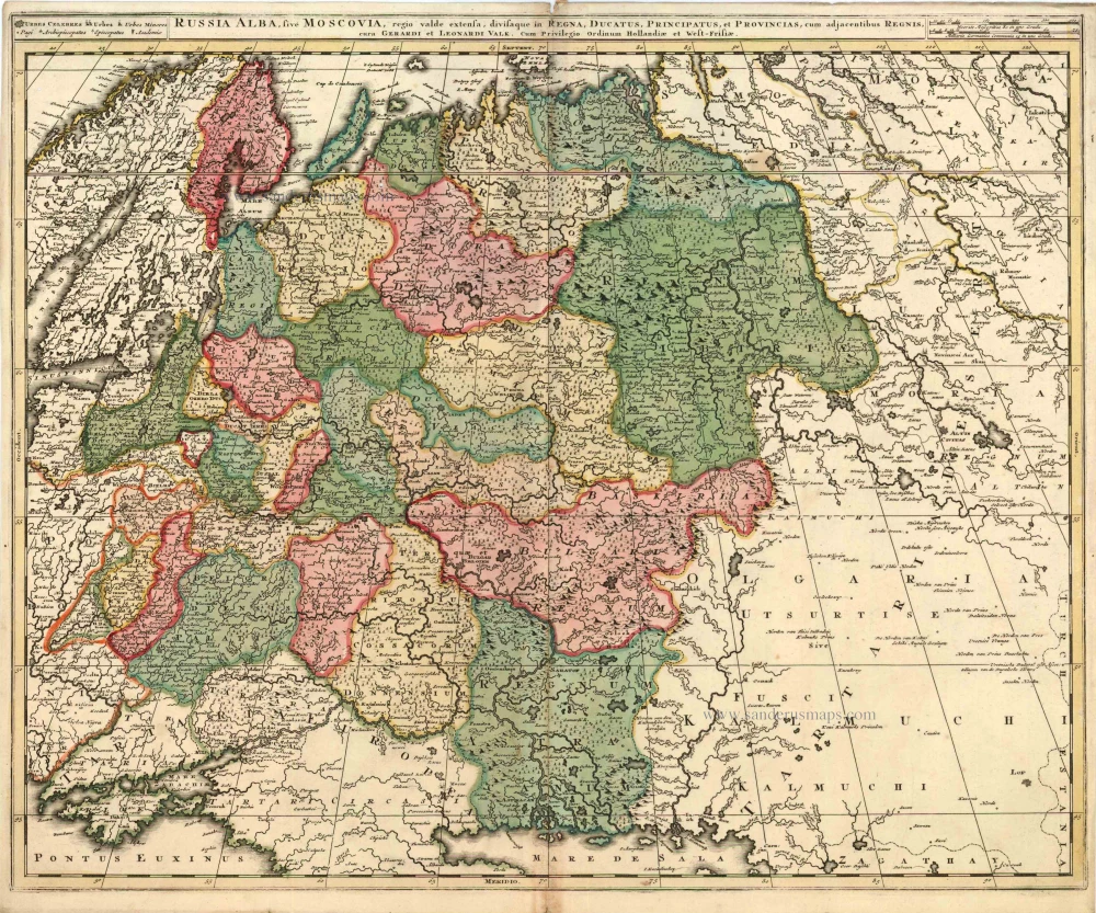
Russia Alba, sive Moscoviae, Regio Valde Extensa, Divisaque in Regna, Ducatus, Principatus, et Provincias, cum Adjacentibus Regnis c. 1702
Russia, by Valk & Schenk.
[Item number: 5099]
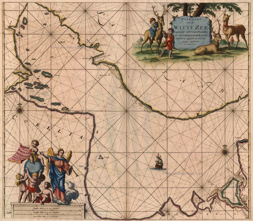
Paskaart van de Witte Zee Beginnende van Pelitza tot Kandalox en van Catsnoes tot aan Kodova. 1697-1709
The White Sea, by Van Keulen Johannes.
[Item number: 5422]
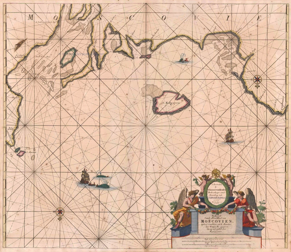
Paskaart vande NoordKust van Moscovien. tussen C. Candenoes ent I. Mauritius. door Teunis Ys opgegeven en int net gestelt door C J Vooght Geometra. 1697-1709
Barents Sea - Russia, by Van Keulen Johannes.
[Item number: 5792]
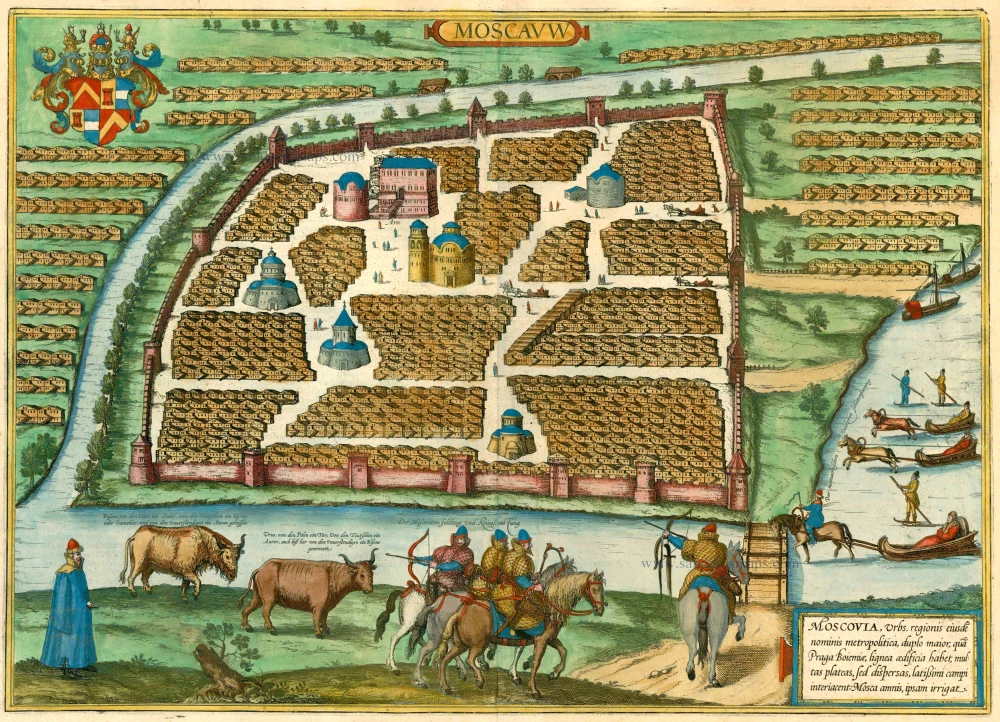
Moscauw - Moscovia, Urbs regionis eiusde nominis metropolitica, duplo maior, ... 1597
Moscow, by Braun and Hogenberg.
[Item number: 24001]
[In Cyrillic characters] Carstvajuscoi Grad Moskva Nacal'noi Gorod useh Moskovskih Gosudarstu ... Urbis Moskvae. 1662
Moskva - Moscow, by Joan Blaeu.
[Item number: 25794]