
Cracow and surroundings, by Georg Braun and Frans Hogenberg. 1617-18
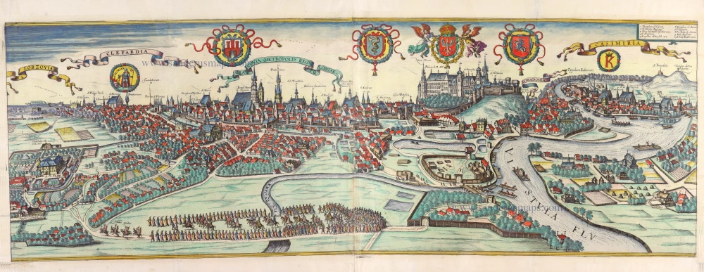
TRANSLATION OF TITLE: Cracow, capital of the Kingdom of Poland.
COMMENTARY BY BRAUN: "The splendid and vast city of Cracow is not only the king's residence but also the place where the royal treasury is. [...] Many people divide the city into three independent parts, each with its town hall and court of justice. One is called Clepardia and lies on the side of Cracow, leading to Silesia. But the city lies on Wawel Hill, with a royal palace at the top. [...] As far as the city of Cracow is concerned, it has many fine churches and monasteries. Almost in the middle of the city is the main church dedicated to St Mary, roofed with shining lead and with two very high towers. An archbishop presides over this church."
This magnificent folded plate is the only one of its kind in the city atlas. It may be seen as a testimony to Cracow's importance at the time as a royal residence, episcopal see and university town. This is a view of the city from the west looking over where the Rudawa flows into the Vistula. The central feature is the royal palace, framed by the Old Town on the left and the suburb of Stradom on the right. The Old Town is surrounded by a moat and a wall with many towers, while the Jewish suburb of Kazimierz can be seen on the far right, on the other side of the Vistula. The foreground scene may represent the Polish king's entry accompanied by knights and ecclesiastical dignitaries. The banderole celebrating Cracow as the royal residence would confirm this. The plate needed to be updated when the book was published, and Georg Braun was required to be better informed, for Cracow had been replaced as the capital by Warsaw under Sigismund III between 1596 and 1611. (Taschen)
Braun G. & Hogenberg F. and the Civitates Orbis Terrarum.
The Civitates Orbis Terrarum, also known as the 'Braun & Hogenberg', is a six-volume town atlas and the most excellent book of town views and plans ever published: 363 engravings, sometimes beautifully coloured. It was one of the best-selling works in the last quarter of the 16th century. Georg Braun, a skilled writer, wrote the text accompanying the plans and views on the verso. Many plates were engraved after the original drawings of a professional artist, Joris Hoefnagel (1542-1600). The first volume was published in Latin in 1572 and the sixth in 1617. Frans Hogenberg, a talented engraver, created the tables for volumes I through IV, and Simon van den Neuwel made those for volumes V and VI. Other contributors were cartographers Daniel Freese and Heinrich Rantzau, who provided valuable geographical information. Works by Jacob van Deventer, Sebastian Münster, and Johannes Stumpf were also used as references. Translations appeared in German and French, making the atlas accessible to a broader audience.
Since its original publication of volume 1 in 1572, the Civitates Orbis Terrarum has left an indelible mark on the history of cartography. Seven more editions followed the first volume in 1575, 1577, 1582, 1588, 1593, 1599, and 1612. Vol.2, initially released in 1575, saw subsequent editions in 1597 and 1612. The subsequent volumes, each a treasure trove of historical insights, graced the world in 1581, 1588, 1593, 1599, and 1606. The German translation of the first volume, a testament to its widespread appeal, debuted in 1574, followed by the French edition in 1575.
Several printers were involved: Theodor Graminaeus, Heinrich von Aich, Gottfried von Kempen, Johannis Sinniger, Bertram Buchholtz, and Peter von Brachel, all of whom worked in Cologne.
Georg Braun (1541-1622)
Georg Braun, the author of the text accompanying the plans and views in the Civitates Orbis Terrarum, was born in Cologne in 1541. After his studies in Cologne, he entered the Jesuit Order as a novice, indicating his commitment to learning and intellectual pursuits. In 1561, he obtained his bachelor's degree; in 1562, he received his Magister Artium, further demonstrating his academic achievements. Although he left the Jesuit Order, he continued his studies in theology, gaining a licentiate in theology. His theological background likely influenced the content and tone of the text in the Civitates Orbis Terrarum, adding a unique perspective to the work.
Frans Hogenberg (1535-1590)
Frans Hogenberg was a Flemish and German painter, engraver, and mapmaker. He was born in Mechelen as the son of Nicolaas Hogenberg.
By the end of the 1560s, Frans Hogenberg was employed upon Abraham Ortelius's Theatrum Orbis Terrarum, published in 1570; he is named an engraver of numerous maps. In 1568, he was banned from Antwerp by the Duke of Alva and travelled to London, where he stayed a few years before emigrating to Cologne. He immediately embarked on his two most important works, the Civitates, published in 1572 and the Geschichtsblätter, which appeared in several series from 1569 until about 1587.
Thanks to large-scale projects like the Geschichtsblätter and the Civitates, Hogenberg's social circumstances improved with each passing year. He died as a wealthy man in Cologne in 1590.
Cracovia Metropolis Regni Poloniae - Lobzovia - Clepardia - Casimiria.
Item Number: 30624 Authenticity Guarantee
Category: Antique maps > Europe > Eastern Europe
Bird's-eye view of Cracow and surroundings by Georg Braun and Frans Hogenberg.
With the key to ten locations.
Title: Cracovia Metropolis Regni Poloniae - Lobzovia - Clepardia - Casimiria.
Date of the first edition: 1617.
Date of this map: 1617-18.
Copper engraving, printed on paper from two plates, joined.
Image size: 370 x 1110mm (14.57 x 43.7 inches).
Sheet size: 395 x 1115mm (15.55 x 43.9 inches).
Verso: Blank
Condition: Original coloured, folds as issued, some discolouration at lower centre.
Condition Rating: A.
From: Civitates Orbis Terrarum. Theatri praecipuarum Totius Mundi Urbium Liber Sextus Anno MDCXVIII. Cologne, Anton Heirat, 1617-18. (Van der Krogt 4, 41:1.6)
TRANSLATION OF TITLE: Cracow, capital of the Kingdom of Poland.
COMMENTARY BY BRAUN: "The splendid and vast city of Cracow is not only the king's residence but also the place where the royal treasury is. [...] Many people divide the city into three independent parts, each with its town hall and court of justice. One is called Clepardia and lies on the side of Cracow, leading to Silesia. But the city lies on Wawel Hill, with a royal palace at the top. [...] As far as the city of Cracow is concerned, it has many fine churches and monasteries. Almost in the middle of the city is the main church dedicated to St Mary, roofed with shining lead and with two very high towers. An archbishop presides over this church."
This magnificent folded plate is the only one of its kind in the city atlas. It may be seen as a testimony to Cracow's importance at the time as a royal residence, episcopal see and university town. This is a view of the city from the west looking over where the Rudawa flows into the Vistula. The central feature is the royal palace, framed by the Old Town on the left and the suburb of Stradom on the right. The Old Town is surrounded by a moat and a wall with many towers, while the Jewish suburb of Kazimierz can be seen on the far right, on the other side of the Vistula. The foreground scene may represent the Polish king's entry accompanied by knights and ecclesiastical dignitaries. The banderole celebrating Cracow as the royal residence would confirm this. The plate needed to be updated when the book was published, and Georg Braun was required to be better informed, for Cracow had been replaced as the capital by Warsaw under Sigismund III between 1596 and 1611. (Taschen)
Braun G. & Hogenberg F. and the Civitates Orbis Terrarum.
The Civitates Orbis Terrarum, also known as the 'Braun & Hogenberg', is a six-volume town atlas and the most excellent book of town views and plans ever published: 363 engravings, sometimes beautifully coloured. It was one of the best-selling works in the last quarter of the 16th century. Georg Braun, a skilled writer, wrote the text accompanying the plans and views on the verso. Many plates were engraved after the original drawings of a professional artist, Joris Hoefnagel (1542-1600). The first volume was published in Latin in 1572 and the sixth in 1617. Frans Hogenberg, a talented engraver, created the tables for volumes I through IV, and Simon van den Neuwel made those for volumes V and VI. Other contributors were cartographers Daniel Freese and Heinrich Rantzau, who provided valuable geographical information. Works by Jacob van Deventer, Sebastian Münster, and Johannes Stumpf were also used as references. Translations appeared in German and French, making the atlas accessible to a broader audience.
Since its original publication of volume 1 in 1572, the Civitates Orbis Terrarum has left an indelible mark on the history of cartography. Seven more editions followed the first volume in 1575, 1577, 1582, 1588, 1593, 1599, and 1612. Vol.2, initially released in 1575, saw subsequent editions in 1597 and 1612. The subsequent volumes, each a treasure trove of historical insights, graced the world in 1581, 1588, 1593, 1599, and 1606. The German translation of the first volume, a testament to its widespread appeal, debuted in 1574, followed by the French edition in 1575.
Several printers were involved: Theodor Graminaeus, Heinrich von Aich, Gottfried von Kempen, Johannis Sinniger, Bertram Buchholtz, and Peter von Brachel, all of whom worked in Cologne.
Georg Braun (1541-1622)
Georg Braun, the author of the text accompanying the plans and views in the Civitates Orbis Terrarum, was born in Cologne in 1541. After his studies in Cologne, he entered the Jesuit Order as a novice, indicating his commitment to learning and intellectual pursuits. In 1561, he obtained his bachelor's degree; in 1562, he received his Magister Artium, further demonstrating his academic achievements. Although he left the Jesuit Order, he continued his studies in theology, gaining a licentiate in theology. His theological background likely influenced the content and tone of the text in the Civitates Orbis Terrarum, adding a unique perspective to the work.
Frans Hogenberg (1535-1590)
Frans Hogenberg was a Flemish and German painter, engraver, and mapmaker. He was born in Mechelen as the son of Nicolaas Hogenberg.
By the end of the 1560s, Frans Hogenberg was employed upon Abraham Ortelius's Theatrum Orbis Terrarum, published in 1570; he is named an engraver of numerous maps. In 1568, he was banned from Antwerp by the Duke of Alva and travelled to London, where he stayed a few years before emigrating to Cologne. He immediately embarked on his two most important works, the Civitates, published in 1572 and the Geschichtsblätter, which appeared in several series from 1569 until about 1587.
Thanks to large-scale projects like the Geschichtsblätter and the Civitates, Hogenberg's social circumstances improved with each passing year. He died as a wealthy man in Cologne in 1590.
Related items
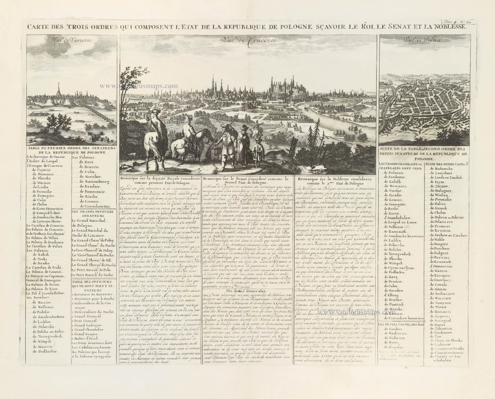
Carte des trois ordres qui composent l'Etat de la République de Pologne sçavoir le Roi, le Senat et la Noblesse. 1714
Krakow, Warsaw, and Vilnius, by Zacharias Châtelain.
[Item number: 29411]
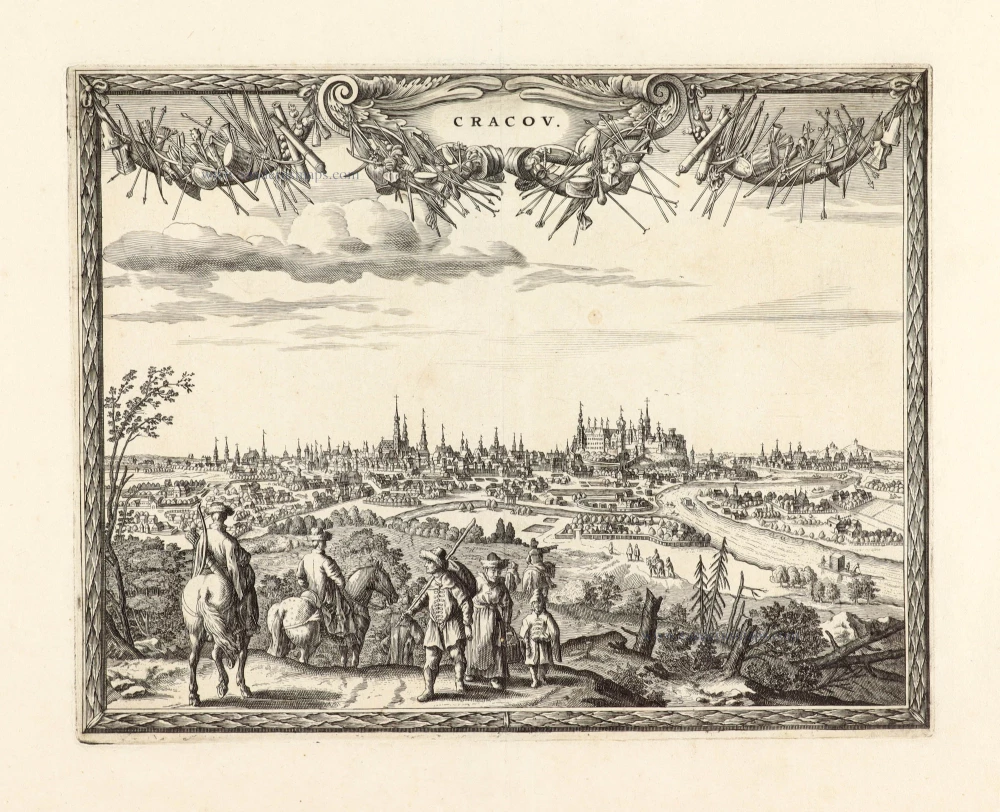
Unrecorded variant of Carel Allard's view of Krakow
Cracov. 1673
View of Krakow by Carel Allard.
[Item number: 30552]