
Gdansk, by Georg Braun and Frans Hogenberg. 1576

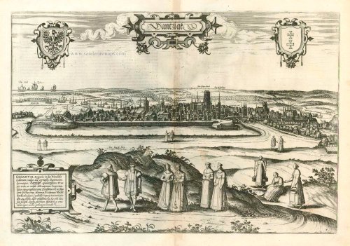
TRANSLATION OF CARTOUCHE TEXT: Gedanum, Krantio, in the native Vendish dialect Gdanum, commonly, but corruptedly, Dantiscum, in German Danzig. Prosperous city in Prussia and well-known trading port. With this topographical map, painted at his expense, the famous and singular patron of learned men Dr Adam Wachendorff, wise and faithful secretary of the Hanseatic League in London, kindly contributed a magnificent adornment for our work.
COMMENTARY BY BRAUN: "The inhabitants of Danzig run to the sea by day and night, carrying fishing nets with them; they wait for slack water and then run naked into the sea during the ebb tide and scoop up from the ground whatever the can find with their fishing nets. [...] And when they have brought in the nets, they run back to the shore where the women are waiting to see what good things they have brought, and shake out the nets, and the women gather up whatever is good."
Gdansk is shown in a view from Gradowa Hill (Hegelsberg) from the direction of the Gulf of Gdansk and the mouth of the Vistula. In the foreground the staffage figures demonstrate the rich clothing of the burghers, peasants and maids and - just like the many ships on the Baltic Sea - the wealth of this trade city. In the silhouette of the city the church of St Mary ( Die Phare Kirch, or parish church) can be identified, the biggest red-brick church in the world, which can accommodate 25,000 people. To the right of it rises the tower of the Gothic town hall. Gdansk was first recorded in 997; from 1308 the city was ruled by the Teutonic Knights, and it became a member of the Hanseatic League in 1361. In 1454 Gdansk, together with the Prussian Confederation, placed itself under the protection of the Polish king. (Taschen)
Braun G. & Hogenberg F. and the Civitates Orbis Terrarum.
The Civitates Orbis Terrarum, also known as the 'Braun & Hogenberg', is a six-volume town atlas and the most excellent book of town views and plans ever published: 363 engravings, sometimes beautifully coloured. It was one of the best-selling works in the last quarter of the 16th century. Georg Braun, a skilled writer, wrote the text accompanying the plans and views on the verso. Many plates were engraved after the original drawings of a professional artist, Joris Hoefnagel (1542-1600). The first volume was published in Latin in 1572 and the sixth in 1617. Frans Hogenberg, a talented engraver, created the tables for volumes I through IV, and Simon van den Neuwel made those for volumes V and VI. Other contributors were cartographers Daniel Freese and Heinrich Rantzau, who provided valuable geographical information. Works by Jacob van Deventer, Sebastian Münster, and Johannes Stumpf were also used as references. Translations appeared in German and French, making the atlas accessible to a broader audience.
Since its original publication of volume 1 in 1572, the Civitates Orbis Terrarum has left an indelible mark on the history of cartography. Seven more editions followed the first volume in 1575, 1577, 1582, 1588, 1593, 1599, and 1612. Vol.2, initially released in 1575, saw subsequent editions in 1597 and 1612. The subsequent volumes, each a treasure trove of historical insights, graced the world in 1581, 1588, 1593, 1599, and 1606. The German translation of the first volume, a testament to its widespread appeal, debuted in 1574, followed by the French edition in 1575.
Several printers were involved: Theodor Graminaeus, Heinrich von Aich, Gottfried von Kempen, Johannis Sinniger, Bertram Buchholtz, and Peter von Brachel, all of whom worked in Cologne.
Georg Braun (1541-1622)
Georg Braun, the author of the text accompanying the plans and views in the Civitates Orbis Terrarum, was born in Cologne in 1541. After his studies in Cologne, he entered the Jesuit Order as a novice, indicating his commitment to learning and intellectual pursuits. In 1561, he obtained his bachelor's degree; in 1562, he received his Magister Artium, further demonstrating his academic achievements. Although he left the Jesuit Order, he continued his studies in theology, gaining a licentiate in theology. His theological background likely influenced the content and tone of the text in the Civitates Orbis Terrarum, adding a unique perspective to the work.
Frans Hogenberg (1535-1590)
Frans Hogenberg was a Flemish and German painter, engraver, and mapmaker. He was born in Mechelen as the son of Nicolaas Hogenberg.
By the end of the 1560s, Frans Hogenberg was employed upon Abraham Ortelius's Theatrum Orbis Terrarum, published in 1570; he is named an engraver of numerous maps. In 1568, he was banned from Antwerp by the Duke of Alva and travelled to London, where he stayed a few years before emigrating to Cologne. He immediately embarked on his two most important works, the Civitates, published in 1572 and the Geschichtsblätter, which appeared in several series from 1569 until about 1587.
Thanks to large-scale projects like the Geschichtsblätter and the Civitates, Hogenberg's social circumstances improved with each passing year. He died as a wealthy man in Cologne in 1590.
Dantzigk - Gedanum, Krantio, in sua Wandalia Gdanum; . . .
Item Number: 4056 Authenticity Guarantee
Category: Antique maps > Europe > Eastern Europe
Old, antique bird’s-eye view of Gdansk, by Georg Braun and Frans Hogenberg.
Title: Dantzigk - Gedanum, Krantio, in sua Wandalia Gdanum; . . .
Date of the first edition: 1575.
Date of this map: 1576.
Copper engraving, printed on paper.
Size (not including margins): 330 x 485mm (12.99 x 19.09 inches).
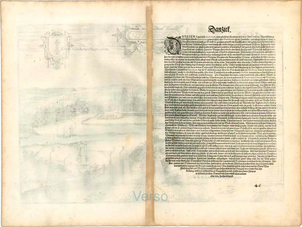
Verso: German text.
Condition: Uncoloured, light browning at centre.
Condition Rating: A.
From: Beschreibung und Contrafactur von den vornembsten Stetten der Welt. Dass ander Buch. Köln, 1576. (Van der Krogt 4, 41:2.2)
TRANSLATION OF CARTOUCHE TEXT: Gedanum, Krantio, in the native Vendish dialect Gdanum, commonly, but corruptedly, Dantiscum, in German Danzig. Prosperous city in Prussia and well-known trading port. With this topographical map, painted at his expense, the famous and singular patron of learned men Dr Adam Wachendorff, wise and faithful secretary of the Hanseatic League in London, kindly contributed a magnificent adornment for our work.
COMMENTARY BY BRAUN: "The inhabitants of Danzig run to the sea by day and night, carrying fishing nets with them; they wait for slack water and then run naked into the sea during the ebb tide and scoop up from the ground whatever the can find with their fishing nets. [...] And when they have brought in the nets, they run back to the shore where the women are waiting to see what good things they have brought, and shake out the nets, and the women gather up whatever is good."
Gdansk is shown in a view from Gradowa Hill (Hegelsberg) from the direction of the Gulf of Gdansk and the mouth of the Vistula. In the foreground the staffage figures demonstrate the rich clothing of the burghers, peasants and maids and - just like the many ships on the Baltic Sea - the wealth of this trade city. In the silhouette of the city the church of St Mary ( Die Phare Kirch, or parish church) can be identified, the biggest red-brick church in the world, which can accommodate 25,000 people. To the right of it rises the tower of the Gothic town hall. Gdansk was first recorded in 997; from 1308 the city was ruled by the Teutonic Knights, and it became a member of the Hanseatic League in 1361. In 1454 Gdansk, together with the Prussian Confederation, placed itself under the protection of the Polish king. (Taschen)
Braun G. & Hogenberg F. and the Civitates Orbis Terrarum.
The Civitates Orbis Terrarum, also known as the 'Braun & Hogenberg', is a six-volume town atlas and the most excellent book of town views and plans ever published: 363 engravings, sometimes beautifully coloured. It was one of the best-selling works in the last quarter of the 16th century. Georg Braun, a skilled writer, wrote the text accompanying the plans and views on the verso. Many plates were engraved after the original drawings of a professional artist, Joris Hoefnagel (1542-1600). The first volume was published in Latin in 1572 and the sixth in 1617. Frans Hogenberg, a talented engraver, created the tables for volumes I through IV, and Simon van den Neuwel made those for volumes V and VI. Other contributors were cartographers Daniel Freese and Heinrich Rantzau, who provided valuable geographical information. Works by Jacob van Deventer, Sebastian Münster, and Johannes Stumpf were also used as references. Translations appeared in German and French, making the atlas accessible to a broader audience.
Since its original publication of volume 1 in 1572, the Civitates Orbis Terrarum has left an indelible mark on the history of cartography. Seven more editions followed the first volume in 1575, 1577, 1582, 1588, 1593, 1599, and 1612. Vol.2, initially released in 1575, saw subsequent editions in 1597 and 1612. The subsequent volumes, each a treasure trove of historical insights, graced the world in 1581, 1588, 1593, 1599, and 1606. The German translation of the first volume, a testament to its widespread appeal, debuted in 1574, followed by the French edition in 1575.
Several printers were involved: Theodor Graminaeus, Heinrich von Aich, Gottfried von Kempen, Johannis Sinniger, Bertram Buchholtz, and Peter von Brachel, all of whom worked in Cologne.
Georg Braun (1541-1622)
Georg Braun, the author of the text accompanying the plans and views in the Civitates Orbis Terrarum, was born in Cologne in 1541. After his studies in Cologne, he entered the Jesuit Order as a novice, indicating his commitment to learning and intellectual pursuits. In 1561, he obtained his bachelor's degree; in 1562, he received his Magister Artium, further demonstrating his academic achievements. Although he left the Jesuit Order, he continued his studies in theology, gaining a licentiate in theology. His theological background likely influenced the content and tone of the text in the Civitates Orbis Terrarum, adding a unique perspective to the work.
Frans Hogenberg (1535-1590)
Frans Hogenberg was a Flemish and German painter, engraver, and mapmaker. He was born in Mechelen as the son of Nicolaas Hogenberg.
By the end of the 1560s, Frans Hogenberg was employed upon Abraham Ortelius's Theatrum Orbis Terrarum, published in 1570; he is named an engraver of numerous maps. In 1568, he was banned from Antwerp by the Duke of Alva and travelled to London, where he stayed a few years before emigrating to Cologne. He immediately embarked on his two most important works, the Civitates, published in 1572 and the Geschichtsblätter, which appeared in several series from 1569 until about 1587.
Thanks to large-scale projects like the Geschichtsblätter and the Civitates, Hogenberg's social circumstances improved with each passing year. He died as a wealthy man in Cologne in 1590.
Related items

Ducatus Silesiae Ligniciensis 1632+
Poland - Legnica, by Hondius H. - Janssonius J.
[Item number: 6942]

Ichnographica Urbis Wratislaviensis Delineatio ... c. 1757
Breslau, by Homann Heirs.
[Item number: 21289]

Die Stat Swybuschin in Nider Schlesien. 1596
Poland - Swiebodzin, by Braun & Hogenberg.
[Item number: 22102]

Die Stat Swybuschin in Nider Schlesien 1596
Swiebodzin, by Georg Braun and Frans Hogenberg.
[Item number: 24182]

Nissa Silesior Sedes Episcopalis [on sheet with] Liginicium c. 1625
Nysa and Legnica (Poland), by Georg Braun and Frans Hogenberg.
[Item number: 24584]

Prussiae Vera Descriptio. 1601
Prussia (Poland) by Abraham Ortelius.
[Item number: 25260]

La Pologne Dressée sur ce qu'en ont donné Starovolsk, Beauplan, Hartnoch, et autres auteurs. [Latin title in upper margin:] Tabula Regni Poloniae, Ducatus Lithuaniae &c. 1730
Poland - Lithuania by Guillaume Delisle, published by Covens & Mortier.
[Item number: 25890]
Les trois Iles, appellées en Allemand Werders, ou sont les Territoires de Dantzic, Marienbourg et Elbing dans la Prusse Royale, avec les Côtes de la Mer Baltique, suivant la description de Olaus Jean Gotho, ... 1713
Gdansk, Marlbork and Elblag, by Pieter van der Aa.
[Item number: 26041]

Dantzig. 1658/60
Gdansk (Danzig), by N. Visscher & P.H. Schut.
[Item number: 26639]

Unrecorded variant of Schut's view of Gdansk (Danzig), by Carel Allard
Dantzig 1673
View of Gdansk (Danzig) by Carel Allard.
[Item number: 30571]

Prussiae Vera Descriptio. 1601
Prussia (Poland) by Abraham Ortelius.
[Item number: 30679]