Riga & Kaliningrad by Braun & Hogenberg 1582
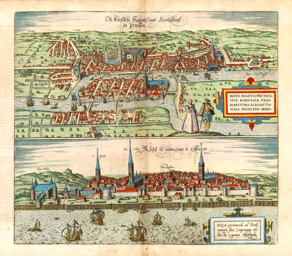


KÖNIGSBERG (KALININGRAD)
CARTOUCHE: Königsberg, a Prussian or Borussian city on the sea, beautiful residence of the prince.
COMMENTARY BY BRAUN: "Königsberg in Prussia is a most noble and famous city, which was founded in the year 1254 by the Teutonic Knights. Alongside their artisan activities, the citizens engaged first and foremost in maritime trade. They thereby dealt in grain, solid and liquid pitch, which the Germans call resin, as well as salt, flax, hemp, wax, wood and also in a great deal of honey and mead; this is a sweet drink that is made from honey and comes from Livonia."
Königsberg's location on the Pregel, shortly before it reaches the Vistula Lagoon on the Baltic Sea, is made especially clear in this combination of elevation and bird's-eye view directly from the south. The river separates the town of Kneiphof on the island from the Old Town (above) and the town of Löbenicht (in the west). With the founding of the Old Town in 1254 by the Teutonic Knights, the two other towns also sprang up, but remained independent until 1724. Within Königsberg proper, the Old Town church (Alt Steter Pfarkirch) can be seen on the left and, beside it to the right, the palace of the Teutonic Knights (Schlos) with its tall tower (Schlos thurn). In 1457 Königsberg became the primary residence of the Grand Master of the Teutonic Knights and in 1525 was incorporated into the Duchy of Prussia. On the Island of Kneiphof lie Königsberg cathedral and on the right the Albertina University (Collegium), founded in 1544 by Albert I, Duke of Brandenburg. Königsberg was completely destroyed in 1944/45. In 1946 Königsberg passed to Russia and was renamed Kaliningrad, and became the capital of the eponymous Russian exclave situated between Lithuania and Poland.
RIGA
CARTOUCHE: Riga, conveniently located on the Daugava, celebrated centre of trade and capital of Latvia.
COMMENTARY BY BRAUN: "The capital of Livonia, Riga, like Danzig in Prussia, is called the most famous trade city by many nations. Like all of Livonia, it lies on a plain. The best-known and largest river in the region is the Daugava, which runs past the city like the Elbe past Hamburg. The Daugava rises in Ruthenia and flows into the Baltic Sea two miles from Riga. Thus the inhabitants and their neighbours are supplied with ample fish and crabs not only from this river but from the sea as well. Likewise they dispose of a great deal of game, which even the farmers are allowed to hunt, although it irks the nobility."
The view of Riga is presented from a fictional standpoint, looking across the Daugava from a southwesterly direction. The city's appearance has changed little today, even after its reconstruction. On the left is Riga castle, built by the Order of the Brothers of the Sword, followed by St James's, St Mary's cathedral and St Peter's. Between these last two, on Town Hall Square, lie the town hall (Das Rathaus) and the Schwarzhäupterhaus ("black heads' house"), the latter erected as a guildhall in 1334. After the arrival of German merchants in the 12th century, Riga was officially founded by Archbishop Albert of Livonia in 1201. It became a Free Imperial City in 1225 and a member of the Hanseatic League in 1282. (Taschen)
Braun G. & Hogenberg F. and the Civitates Orbis Terrarum.
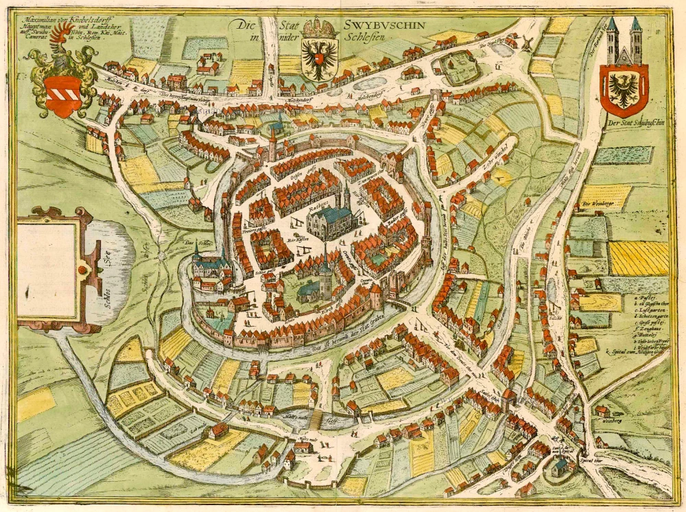
The Civitates Orbis Terrarum, also known as the 'Braun & Hogenberg', is a six-volume town atlas and the most excellent book of town views and plans ever published: 363 engravings, sometimes beautifully coloured. It was one of the best-selling works in the last quarter of the 16th century. Georg Braun, a skilled writer, wrote the text accompanying the plans and views on the verso. Many plates were engraved after the original drawings of a professional artist, Joris Hoefnagel (1542-1600). The first volume was published in Latin in 1572 and the sixth in 1617. Frans Hogenberg, a talented engraver, created the tables for volumes I through IV, and Simon van den Neuwel made those for volumes V and VI. Other contributors were cartographers Daniel Freese and Heinrich Rantzau, who provided valuable geographical information. Works by Jacob van Deventer, Sebastian Münster, and Johannes Stumpf were also used as references. Translations appeared in German and French, making the atlas accessible to a broader audience.
Since its original publication of volume 1 in 1572, the Civitates Orbis Terrarum has left an indelible mark on the history of cartography. Seven more editions followed the first volume in 1575, 1577, 1582, 1588, 1593, 1599, and 1612. Vol.2, initially released in 1575, saw subsequent editions in 1597 and 1612. The subsequent volumes, each a treasure trove of historical insights, graced the world in 1581, 1588, 1593, 1599, and 1606. The German translation of the first volume, a testament to its widespread appeal, debuted in 1574, followed by the French edition in 1575.
Several printers were involved: Theodor Graminaeus, Heinrich von Aich, Gottfried von Kempen, Johannis Sinniger, Bertram Buchholtz, and Peter von Brachel, all of whom worked in Cologne.
Georg Braun (1541-1622)
Georg Braun, the author of the text accompanying the plans and views in the Civitates Orbis Terrarum, was born in Cologne in 1541. After his studies in Cologne, he entered the Jesuit Order as a novice, indicating his commitment to learning and intellectual pursuits. In 1561, he obtained his bachelor's degree; in 1562, he received his Magister Artium, further demonstrating his academic achievements. Although he left the Jesuit Order, he continued his studies in theology, gaining a licentiate in theology. His theological background likely influenced the content and tone of the text in the Civitates Orbis Terrarum, adding a unique perspective to the work.
Frans Hogenberg (1535-1590)
Frans Hogenberg was a Flemish and German painter, engraver, and mapmaker. He was born in Mechelen as the son of Nicolaas Hogenberg.
By the end of the 1560s, Frans Hogenberg was employed upon Abraham Ortelius's Theatrum Orbis Terrarum, published in 1570; he is named an engraver of numerous maps. In 1568, he was banned from Antwerp by the Duke of Alva and travelled to London, where he stayed a few years before emigrating to Cologne. He immediately embarked on his two most important works, the Civitates, published in 1572 and the Geschichtsblätter, which appeared in several series from 1569 until about 1587.
Thanks to large-scale projects like the Geschichtsblätter and the Civitates, Hogenberg's social circumstances improved with each passing year. He died as a wealthy man in Cologne in 1590.
Die Furstliche Hauptt Statt Konigssbergk in Preussen. Mons Regius; Prussiae, ... - Riga, Percommode ad Duna Amnem Sita, Emporium Celebre, et Livoniae Metropolis.
Item Number: 14166 Authenticity Guarantee
Category: Antique maps > Europe > Eastern Europe
Old, antique map with two bird's-eye views by Braun and Hogenberg on one sheet: Kaliningrad and Riga.
The two views are possibly derived from the views in Münster's Cosmographia, 1550.
Date of the first edition: 1581
Date of this map: 1582
Copper engraving
Size: 36 x 41cm (14 x 16 inches)
Verso text: German
Condition: Original coloured, some browning along centrefold.
Condition Rating: A+
References: Van der Krogt 4, 2011; Fauser, 6726 & 11781;Taschen, Br. Hog., p.249.
From: Contrafactur und Beschreibung von den vornembsten Stetten der Welt. Liber Tertius. Köln, 1582. (Van der Krogt 4, 41:2.3)
KÖNIGSBERG (KALININGRAD)
CARTOUCHE: Königsberg, a Prussian or Borussian city on the sea, beautiful residence of the prince.
COMMENTARY BY BRAUN: "Königsberg in Prussia is a most noble and famous city, which was founded in the year 1254 by the Teutonic Knights. Alongside their artisan activities, the citizens engaged first and foremost in maritime trade. They thereby dealt in grain, solid and liquid pitch, which the Germans call resin, as well as salt, flax, hemp, wax, wood and also in a great deal of honey and mead; this is a sweet drink that is made from honey and comes from Livonia."
Königsberg's location on the Pregel, shortly before it reaches the Vistula Lagoon on the Baltic Sea, is made especially clear in this combination of elevation and bird's-eye view directly from the south. The river separates the town of Kneiphof on the island from the Old Town (above) and the town of Löbenicht (in the west). With the founding of the Old Town in 1254 by the Teutonic Knights, the two other towns also sprang up, but remained independent until 1724. Within Königsberg proper, the Old Town church (Alt Steter Pfarkirch) can be seen on the left and, beside it to the right, the palace of the Teutonic Knights (Schlos) with its tall tower (Schlos thurn). In 1457 Königsberg became the primary residence of the Grand Master of the Teutonic Knights and in 1525 was incorporated into the Duchy of Prussia. On the Island of Kneiphof lie Königsberg cathedral and on the right the Albertina University (Collegium), founded in 1544 by Albert I, Duke of Brandenburg. Königsberg was completely destroyed in 1944/45. In 1946 Königsberg passed to Russia and was renamed Kaliningrad, and became the capital of the eponymous Russian exclave situated between Lithuania and Poland.
RIGA
CARTOUCHE: Riga, conveniently located on the Daugava, celebrated centre of trade and capital of Latvia.
COMMENTARY BY BRAUN: "The capital of Livonia, Riga, like Danzig in Prussia, is called the most famous trade city by many nations. Like all of Livonia, it lies on a plain. The best-known and largest river in the region is the Daugava, which runs past the city like the Elbe past Hamburg. The Daugava rises in Ruthenia and flows into the Baltic Sea two miles from Riga. Thus the inhabitants and their neighbours are supplied with ample fish and crabs not only from this river but from the sea as well. Likewise they dispose of a great deal of game, which even the farmers are allowed to hunt, although it irks the nobility."
The view of Riga is presented from a fictional standpoint, looking across the Daugava from a southwesterly direction. The city's appearance has changed little today, even after its reconstruction. On the left is Riga castle, built by the Order of the Brothers of the Sword, followed by St James's, St Mary's cathedral and St Peter's. Between these last two, on Town Hall Square, lie the town hall (Das Rathaus) and the Schwarzhäupterhaus ("black heads' house"), the latter erected as a guildhall in 1334. After the arrival of German merchants in the 12th century, Riga was officially founded by Archbishop Albert of Livonia in 1201. It became a Free Imperial City in 1225 and a member of the Hanseatic League in 1282. (Taschen)
Braun G. & Hogenberg F. and the Civitates Orbis Terrarum.
The Civitates Orbis Terrarum, also known as the 'Braun & Hogenberg', is a six-volume town atlas and the most excellent book of town views and plans ever published: 363 engravings, sometimes beautifully coloured. It was one of the best-selling works in the last quarter of the 16th century. Georg Braun, a skilled writer, wrote the text accompanying the plans and views on the verso. Many plates were engraved after the original drawings of a professional artist, Joris Hoefnagel (1542-1600). The first volume was published in Latin in 1572 and the sixth in 1617. Frans Hogenberg, a talented engraver, created the tables for volumes I through IV, and Simon van den Neuwel made those for volumes V and VI. Other contributors were cartographers Daniel Freese and Heinrich Rantzau, who provided valuable geographical information. Works by Jacob van Deventer, Sebastian Münster, and Johannes Stumpf were also used as references. Translations appeared in German and French, making the atlas accessible to a broader audience.
Since its original publication of volume 1 in 1572, the Civitates Orbis Terrarum has left an indelible mark on the history of cartography. Seven more editions followed the first volume in 1575, 1577, 1582, 1588, 1593, 1599, and 1612. Vol.2, initially released in 1575, saw subsequent editions in 1597 and 1612. The subsequent volumes, each a treasure trove of historical insights, graced the world in 1581, 1588, 1593, 1599, and 1606. The German translation of the first volume, a testament to its widespread appeal, debuted in 1574, followed by the French edition in 1575.
Several printers were involved: Theodor Graminaeus, Heinrich von Aich, Gottfried von Kempen, Johannis Sinniger, Bertram Buchholtz, and Peter von Brachel, all of whom worked in Cologne.
Georg Braun (1541-1622)
Georg Braun, the author of the text accompanying the plans and views in the Civitates Orbis Terrarum, was born in Cologne in 1541. After his studies in Cologne, he entered the Jesuit Order as a novice, indicating his commitment to learning and intellectual pursuits. In 1561, he obtained his bachelor's degree; in 1562, he received his Magister Artium, further demonstrating his academic achievements. Although he left the Jesuit Order, he continued his studies in theology, gaining a licentiate in theology. His theological background likely influenced the content and tone of the text in the Civitates Orbis Terrarum, adding a unique perspective to the work.
Frans Hogenberg (1535-1590)
Frans Hogenberg was a Flemish and German painter, engraver, and mapmaker. He was born in Mechelen as the son of Nicolaas Hogenberg.
By the end of the 1560s, Frans Hogenberg was employed upon Abraham Ortelius's Theatrum Orbis Terrarum, published in 1570; he is named an engraver of numerous maps. In 1568, he was banned from Antwerp by the Duke of Alva and travelled to London, where he stayed a few years before emigrating to Cologne. He immediately embarked on his two most important works, the Civitates, published in 1572 and the Geschichtsblätter, which appeared in several series from 1569 until about 1587.
Thanks to large-scale projects like the Geschichtsblätter and the Civitates, Hogenberg's social circumstances improved with each passing year. He died as a wealthy man in Cologne in 1590.