
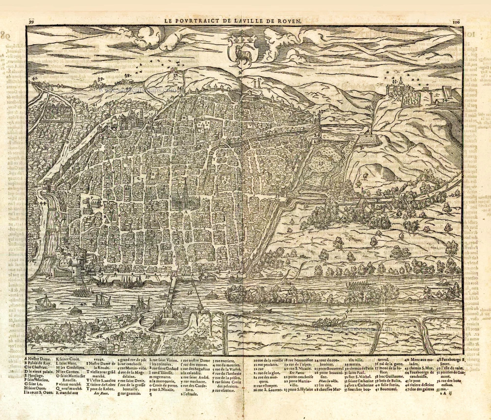
Rouen, by Braun and Hogenberg. 1581-88
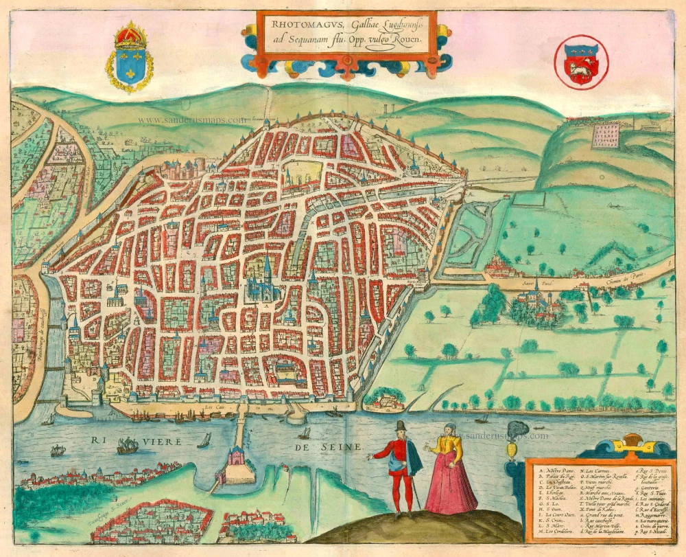


TRANSLATION OF CARTOUCHE TEXT: Rhotomagus, in French Rouen, city in Gallia Lugdunensis on the Seine.
COMMENTARY BY BRAUN: "In hardly another city is the merchant community more experienced on water and land than in this city on the Seine. The river accepts even the biggest ships thanks to the nearby sea, and trade can be conducted with the East and West, as far away as India. Amongst the most important buildings to be seen in Rouen is, without doubt, the bridge over the Seine, which was erected with such skill that one can pay only the highest tribute to the architect both for the structural planning and the execution, the more so given that it was an exceedingly complicated and dangerous work since the construction was exposed to the tides. Nevertheless, it was possible to erect this bridge with quadrangular components, with large and solid columns and flying buttresses, unusually tall and wide."
The bird's-eye view from the north conveys a clear impression of the city's layout and depicts the construction progress on the bridge over the Seine in the foreground. The most prominent building is the Gothic cathedral of Notre Dame (A), which commenced in the 12th century on top of a former Romanesque structure. The cathedral today has seven towers, with only three: the Tour Saint-Romain, the Tour de Beurre in the Flamboyant style with an octagonal crown and the crossing tower. The large astronomical clock is not far away on the left (Gros Horloge, E). Above the cathedral lies the former Benedictine abbey of Saint-Ouen (I/H) and, on the right, the smaller Gothic church of Saint-Maclou (F). On Place du Vieux Marché (R) Joan of Arc was burned on 30 May 1431. (Taschen)
Braun G. & Hogenberg F. and the Civitates Orbis Terrarum.
The Civitates Orbis Terrarum, also known as the 'Braun & Hogenberg', is a six-volume town atlas and the most excellent book of town views and plans ever published: 363 engravings, sometimes beautifully coloured. It was one of the best-selling works in the last quarter of the 16th century. Georg Braun, a skilled writer, wrote the text accompanying the plans and views on the verso. Many plates were engraved after the original drawings of a professional artist, Joris Hoefnagel (1542-1600). The first volume was published in Latin in 1572 and the sixth in 1617. Frans Hogenberg, a talented engraver, created the tables for volumes I through IV, and Simon van den Neuwel made those for volumes V and VI. Other contributors were cartographers Daniel Freese and Heinrich Rantzau, who provided valuable geographical information. Works by Jacob van Deventer, Sebastian Münster, and Johannes Stumpf were also used as references. Translations appeared in German and French, making the atlas accessible to a broader audience.
Since its original publication of volume 1 in 1572, the Civitates Orbis Terrarum has left an indelible mark on the history of cartography. Seven more editions followed the first volume in 1575, 1577, 1582, 1588, 1593, 1599, and 1612. Vol.2, initially released in 1575, saw subsequent editions in 1597 and 1612. The subsequent volumes, each a treasure trove of historical insights, graced the world in 1581, 1588, 1593, 1599, and 1606. The German translation of the first volume, a testament to its widespread appeal, debuted in 1574, followed by the French edition in 1575.
Several printers were involved: Theodor Graminaeus, Heinrich von Aich, Gottfried von Kempen, Johannis Sinniger, Bertram Buchholtz, and Peter von Brachel, all of whom worked in Cologne.
Georg Braun (1541-1622)
Georg Braun, the author of the text accompanying the plans and views in the Civitates Orbis Terrarum, was born in Cologne in 1541. After his studies in Cologne, he entered the Jesuit Order as a novice, indicating his commitment to learning and intellectual pursuits. In 1561, he obtained his bachelor's degree; in 1562, he received his Magister Artium, further demonstrating his academic achievements. Although he left the Jesuit Order, he continued his studies in theology, gaining a licentiate in theology. His theological background likely influenced the content and tone of the text in the Civitates Orbis Terrarum, adding a unique perspective to the work.
Frans Hogenberg (1535-1590)
Frans Hogenberg was a Flemish and German painter, engraver, and mapmaker. He was born in Mechelen as the son of Nicolaas Hogenberg.
By the end of the 1560s, Frans Hogenberg was employed upon Abraham Ortelius's Theatrum Orbis Terrarum, published in 1570; he is named an engraver of numerous maps. In 1568, he was banned from Antwerp by the Duke of Alva and travelled to London, where he stayed a few years before emigrating to Cologne. He immediately embarked on his two most important works, the Civitates, published in 1572 and the Geschichtsblätter, which appeared in several series from 1569 until about 1587.
Thanks to large-scale projects like the Geschichtsblätter and the Civitates, Hogenberg's social circumstances improved with each passing year. He died as a wealthy man in Cologne in 1590.
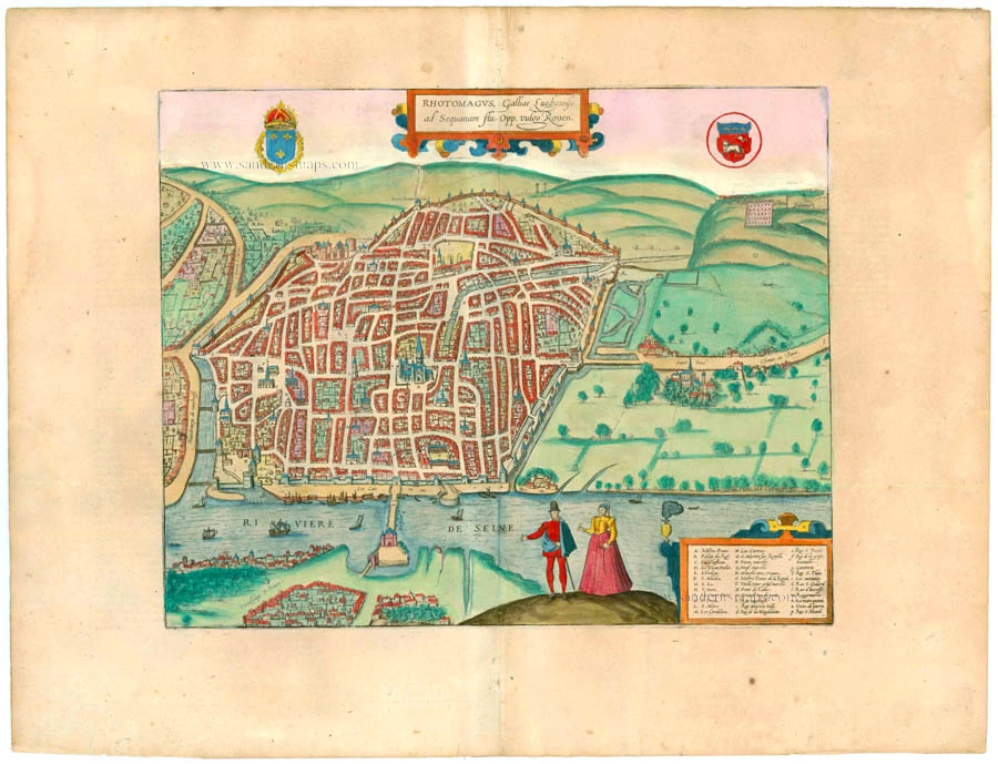
Rhotomagus, Galliae Lugdunensis as Sequanam flu. Opp. vulgo Rouen.
Item Number: 22190 Authenticity Guarantee
Category: Antique maps > Europe > France - Cities
Bird's-eye view plan of Rouen by Georg Braun and Frans Hogenberg.
With a French key to locations. Two costume figures at the bottom.
Title: Rhotomagus, Galliae Lugdunensis as Sequanam flu. Opp. vulgo Rouen.
Date: 1581-88.
Copper engraving, printed on paper.
Size (not including margins): 305 x 375mm (12.01 x 14.76 inches).
Verso: Latin text.
Condition: Superb old colour, excellent.
Condition Rating: A+.
From: Civitates Orbis Terrarum. . Liber tertius. Köln, G. Kempen, 1581-88. (Koeman, B&H3)
TRANSLATION OF CARTOUCHE TEXT: Rhotomagus, in French Rouen, city in Gallia Lugdunensis on the Seine.
COMMENTARY BY BRAUN: "In hardly another city is the merchant community more experienced on water and land than in this city on the Seine. The river accepts even the biggest ships thanks to the nearby sea, and trade can be conducted with the East and West, as far away as India. Amongst the most important buildings to be seen in Rouen is, without doubt, the bridge over the Seine, which was erected with such skill that one can pay only the highest tribute to the architect both for the structural planning and the execution, the more so given that it was an exceedingly complicated and dangerous work since the construction was exposed to the tides. Nevertheless, it was possible to erect this bridge with quadrangular components, with large and solid columns and flying buttresses, unusually tall and wide."
The bird's-eye view from the north conveys a clear impression of the city's layout and depicts the construction progress on the bridge over the Seine in the foreground. The most prominent building is the Gothic cathedral of Notre Dame (A), which commenced in the 12th century on top of a former Romanesque structure. The cathedral today has seven towers, with only three: the Tour Saint-Romain, the Tour de Beurre in the Flamboyant style with an octagonal crown and the crossing tower. The large astronomical clock is not far away on the left (Gros Horloge, E). Above the cathedral lies the former Benedictine abbey of Saint-Ouen (I/H) and, on the right, the smaller Gothic church of Saint-Maclou (F). On Place du Vieux Marché (R) Joan of Arc was burned on 30 May 1431. (Taschen)
Braun G. & Hogenberg F. and the Civitates Orbis Terrarum.
The Civitates Orbis Terrarum, also known as the 'Braun & Hogenberg', is a six-volume town atlas and the most excellent book of town views and plans ever published: 363 engravings, sometimes beautifully coloured. It was one of the best-selling works in the last quarter of the 16th century. Georg Braun, a skilled writer, wrote the text accompanying the plans and views on the verso. Many plates were engraved after the original drawings of a professional artist, Joris Hoefnagel (1542-1600). The first volume was published in Latin in 1572 and the sixth in 1617. Frans Hogenberg, a talented engraver, created the tables for volumes I through IV, and Simon van den Neuwel made those for volumes V and VI. Other contributors were cartographers Daniel Freese and Heinrich Rantzau, who provided valuable geographical information. Works by Jacob van Deventer, Sebastian Münster, and Johannes Stumpf were also used as references. Translations appeared in German and French, making the atlas accessible to a broader audience.
Since its original publication of volume 1 in 1572, the Civitates Orbis Terrarum has left an indelible mark on the history of cartography. Seven more editions followed the first volume in 1575, 1577, 1582, 1588, 1593, 1599, and 1612. Vol.2, initially released in 1575, saw subsequent editions in 1597 and 1612. The subsequent volumes, each a treasure trove of historical insights, graced the world in 1581, 1588, 1593, 1599, and 1606. The German translation of the first volume, a testament to its widespread appeal, debuted in 1574, followed by the French edition in 1575.
Several printers were involved: Theodor Graminaeus, Heinrich von Aich, Gottfried von Kempen, Johannis Sinniger, Bertram Buchholtz, and Peter von Brachel, all of whom worked in Cologne.
Georg Braun (1541-1622)
Georg Braun, the author of the text accompanying the plans and views in the Civitates Orbis Terrarum, was born in Cologne in 1541. After his studies in Cologne, he entered the Jesuit Order as a novice, indicating his commitment to learning and intellectual pursuits. In 1561, he obtained his bachelor's degree; in 1562, he received his Magister Artium, further demonstrating his academic achievements. Although he left the Jesuit Order, he continued his studies in theology, gaining a licentiate in theology. His theological background likely influenced the content and tone of the text in the Civitates Orbis Terrarum, adding a unique perspective to the work.
Frans Hogenberg (1535-1590)
Frans Hogenberg was a Flemish and German painter, engraver, and mapmaker. He was born in Mechelen as the son of Nicolaas Hogenberg.
By the end of the 1560s, Frans Hogenberg was employed upon Abraham Ortelius's Theatrum Orbis Terrarum, published in 1570; he is named an engraver of numerous maps. In 1568, he was banned from Antwerp by the Duke of Alva and travelled to London, where he stayed a few years before emigrating to Cologne. He immediately embarked on his two most important works, the Civitates, published in 1572 and the Geschichtsblätter, which appeared in several series from 1569 until about 1587.
Thanks to large-scale projects like the Geschichtsblätter and the Civitates, Hogenberg's social circumstances improved with each passing year. He died as a wealthy man in Cologne in 1590.
Related items
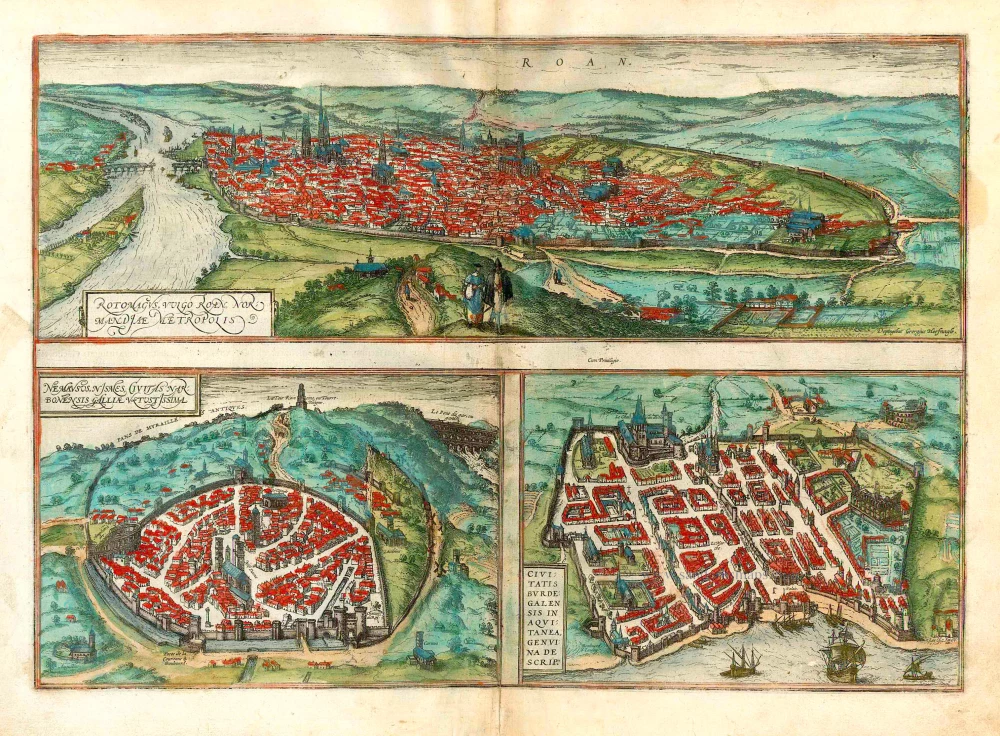
Rotomagus, vulgo Roan, Normandiae Metropolis [on sheet with] Nemavsus, Nismes, Civitas Narbonensie Galliae Vetustissima [and] Civitas Burdegalensis in Aquitanea, Genuina Descrip. 1582
Rouen - Nîmes - Bordeaux, by Braun Georg & Hogenberg Frans.
[Item number: 26680]
Le Pourtraict de la ville de Rouen. 1575
Rouen, by François de Belleforest.
[Item number: 27190]