Besançon, by Georg Braun & Frans Hogenberg. 1623


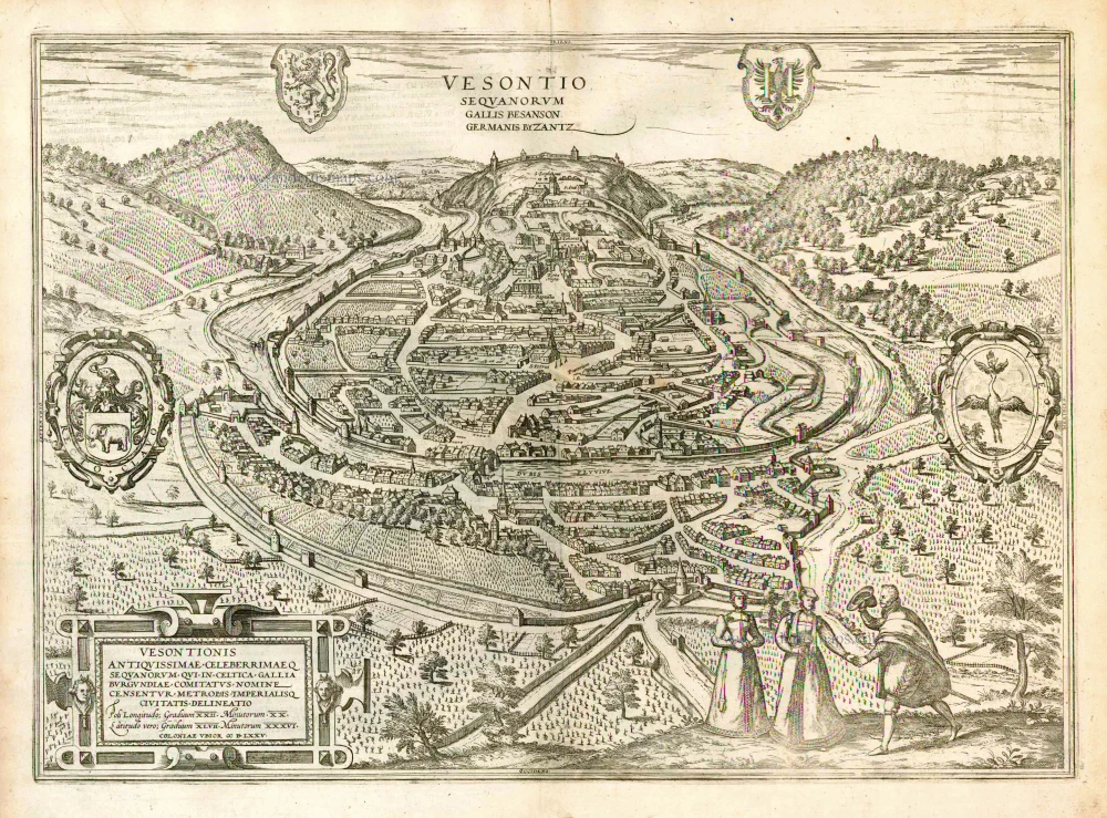
CAPTION: The Sequani called this city Vesontion, the French call it Besançon, and the Germans Byzantz.
TRANSLATION OF CARTOUCHE TEXT: Drawing of the very ancient and highly famed Besançon, city of the Sequani, which is held to be the founding city and capital of the Duchy of Burgundy in Celtic Gaul. ... Cologne, 1575.
COMMENTARY BY BRAUN: "Besançon is a famous and splendid city in Burgundy and richly endowed by nature. The Doubs flows around the city, it is the capital of the county and is annexed to the Empire. It is so old that no mention of its founding can be found in the chronicles. [...] Because of its fruits and abundant grain, it is often called the breadbasket of Burgundy.".
This plate of Besançon is a bird's-eye view from a low angle, seen from the west and overlooking the Doubs. Julius Caesar conquered the city called Chrysopolis ("golden city") in Greek in 58 BC and expanded it. A relic of Besançon's Roman past, the Porte Noire, a Roman triumphal arch from the 2nd century, can be seen in the middle of the plate. The 16th century was an important phase in the city's development, with the construction of the Palais Granvelle (today Musée de Temps) for Nicolas Perrenot de Granvelle, initially Charles V's chancellor and later his minister of justice, the Tour de la Pelote, the Porte Rivotte, the town hall and the law courts. Today's cityscape is characterized by the architecture of Sébastien Le Prestre, Marquis de Vauban. (Taschen)
Braun G. & Hogenberg F. and the Civitates Orbis Terrarum.
The Civitates Orbis Terrarum, also known as the 'Braun & Hogenberg', is a six-volume town atlas and the most excellent book of town views and plans ever published: 363 engravings, sometimes beautifully coloured. It was one of the best-selling works in the last quarter of the 16th century. Georg Braun, a skilled writer, wrote the text accompanying the plans and views on the verso. Many plates were engraved after the original drawings of a professional artist, Joris Hoefnagel (1542-1600). The first volume was published in Latin in 1572 and the sixth in 1617. Frans Hogenberg, a talented engraver, created the tables for volumes I through IV, and Simon van den Neuwel made those for volumes V and VI. Other contributors were cartographers Daniel Freese and Heinrich Rantzau, who provided valuable geographical information. Works by Jacob van Deventer, Sebastian Münster, and Johannes Stumpf were also used as references. Translations appeared in German and French, making the atlas accessible to a broader audience.
Since its original publication of volume 1 in 1572, the Civitates Orbis Terrarum has left an indelible mark on the history of cartography. Seven more editions followed the first volume in 1575, 1577, 1582, 1588, 1593, 1599, and 1612. Vol.2, initially released in 1575, saw subsequent editions in 1597 and 1612. The subsequent volumes, each a treasure trove of historical insights, graced the world in 1581, 1588, 1593, 1599, and 1606. The German translation of the first volume, a testament to its widespread appeal, debuted in 1574, followed by the French edition in 1575.
Several printers were involved: Theodor Graminaeus, Heinrich von Aich, Gottfried von Kempen, Johannis Sinniger, Bertram Buchholtz, and Peter von Brachel, all of whom worked in Cologne.
Georg Braun (1541-1622)
Georg Braun, the author of the text accompanying the plans and views in the Civitates Orbis Terrarum, was born in Cologne in 1541. After his studies in Cologne, he entered the Jesuit Order as a novice, indicating his commitment to learning and intellectual pursuits. In 1561, he obtained his bachelor's degree; in 1562, he received his Magister Artium, further demonstrating his academic achievements. Although he left the Jesuit Order, he continued his studies in theology, gaining a licentiate in theology. His theological background likely influenced the content and tone of the text in the Civitates Orbis Terrarum, adding a unique perspective to the work.
Frans Hogenberg (1535-1590)
Frans Hogenberg was a Flemish and German painter, engraver, and mapmaker. He was born in Mechelen as the son of Nicolaas Hogenberg.
By the end of the 1560s, Frans Hogenberg was employed upon Abraham Ortelius's Theatrum Orbis Terrarum, published in 1570; he is named an engraver of numerous maps. In 1568, he was banned from Antwerp by the Duke of Alva and travelled to London, where he stayed a few years before emigrating to Cologne. He immediately embarked on his two most important works, the Civitates, published in 1572 and the Geschichtsblätter, which appeared in several series from 1569 until about 1587.
Thanks to large-scale projects like the Geschichtsblätter and the Civitates, Hogenberg's social circumstances improved with each passing year. He died as a wealthy man in Cologne in 1590.
Vesontionis Antiquissimae Celeberrimaeq Sequanorum qui in Celtica Gallia Burgundiae Comitatus Nomine Censentur Metropolis Imperialisq Civitatis delineatio.
Item Number: 23259 Authenticity Guarantee
Category: Antique maps > Europe > France - Cities
Old, antique map - bird's-eye view of Besançon, by Georg Braun & Frans Hogenberg.
Carte ancienne - vue de Besançon, par Georg Braun & Frans Hogenberg.
Made after a view from Münster's Cosmographia, 1572.
Title: Vesontionis Antiquissimae Celeberrimaeq Sequanorum qui in Celtica Gallia Burgundiae Comitatus Nomine Censentur Metropolis Imperialisq Civitatis delineatio.
Coloniae Ubior MDLXXV.
Cartographer: Jean Matal.
Date of the first edition: 1575.
Date of this map: 1623.
Date on map: 1575.
Copper engraving, printed on paper.
Size (not including margins): 355 x 500mm (13.98 x 19.69 inches).
Verso: Latin text.
Condition: Excellent, superb old colour.
Condition Rating: A+.
References: Van der Krogt 4, #473; Taschen, Br. Hog., p.153; Fauser #1425
From: Civitates Orbis Terrarum, ... Part 2: De Praecipuis, Totius Universi Urbibus, Liber Secundus. Köln, Petrus von Brachel, 1623. (Van der Krogt 4, 41:1.2)
CAPTION: The Sequani called this city Vesontion, the French call it Besançon, and the Germans Byzantz.
TRANSLATION OF CARTOUCHE TEXT: Drawing of the very ancient and highly famed Besançon, city of the Sequani, which is held to be the founding city and capital of the Duchy of Burgundy in Celtic Gaul. ... Cologne, 1575.
COMMENTARY BY BRAUN: "Besançon is a famous and splendid city in Burgundy and richly endowed by nature. The Doubs flows around the city, it is the capital of the county and is annexed to the Empire. It is so old that no mention of its founding can be found in the chronicles. [...] Because of its fruits and abundant grain, it is often called the breadbasket of Burgundy.".
This plate of Besançon is a bird's-eye view from a low angle, seen from the west and overlooking the Doubs. Julius Caesar conquered the city called Chrysopolis ("golden city") in Greek in 58 BC and expanded it. A relic of Besançon's Roman past, the Porte Noire, a Roman triumphal arch from the 2nd century, can be seen in the middle of the plate. The 16th century was an important phase in the city's development, with the construction of the Palais Granvelle (today Musée de Temps) for Nicolas Perrenot de Granvelle, initially Charles V's chancellor and later his minister of justice, the Tour de la Pelote, the Porte Rivotte, the town hall and the law courts. Today's cityscape is characterized by the architecture of Sébastien Le Prestre, Marquis de Vauban. (Taschen)
Braun G. & Hogenberg F. and the Civitates Orbis Terrarum.
The Civitates Orbis Terrarum, also known as the 'Braun & Hogenberg', is a six-volume town atlas and the most excellent book of town views and plans ever published: 363 engravings, sometimes beautifully coloured. It was one of the best-selling works in the last quarter of the 16th century. Georg Braun, a skilled writer, wrote the text accompanying the plans and views on the verso. Many plates were engraved after the original drawings of a professional artist, Joris Hoefnagel (1542-1600). The first volume was published in Latin in 1572 and the sixth in 1617. Frans Hogenberg, a talented engraver, created the tables for volumes I through IV, and Simon van den Neuwel made those for volumes V and VI. Other contributors were cartographers Daniel Freese and Heinrich Rantzau, who provided valuable geographical information. Works by Jacob van Deventer, Sebastian Münster, and Johannes Stumpf were also used as references. Translations appeared in German and French, making the atlas accessible to a broader audience.
Since its original publication of volume 1 in 1572, the Civitates Orbis Terrarum has left an indelible mark on the history of cartography. Seven more editions followed the first volume in 1575, 1577, 1582, 1588, 1593, 1599, and 1612. Vol.2, initially released in 1575, saw subsequent editions in 1597 and 1612. The subsequent volumes, each a treasure trove of historical insights, graced the world in 1581, 1588, 1593, 1599, and 1606. The German translation of the first volume, a testament to its widespread appeal, debuted in 1574, followed by the French edition in 1575.
Several printers were involved: Theodor Graminaeus, Heinrich von Aich, Gottfried von Kempen, Johannis Sinniger, Bertram Buchholtz, and Peter von Brachel, all of whom worked in Cologne.
Georg Braun (1541-1622)
Georg Braun, the author of the text accompanying the plans and views in the Civitates Orbis Terrarum, was born in Cologne in 1541. After his studies in Cologne, he entered the Jesuit Order as a novice, indicating his commitment to learning and intellectual pursuits. In 1561, he obtained his bachelor's degree; in 1562, he received his Magister Artium, further demonstrating his academic achievements. Although he left the Jesuit Order, he continued his studies in theology, gaining a licentiate in theology. His theological background likely influenced the content and tone of the text in the Civitates Orbis Terrarum, adding a unique perspective to the work.
Frans Hogenberg (1535-1590)
Frans Hogenberg was a Flemish and German painter, engraver, and mapmaker. He was born in Mechelen as the son of Nicolaas Hogenberg.
By the end of the 1560s, Frans Hogenberg was employed upon Abraham Ortelius's Theatrum Orbis Terrarum, published in 1570; he is named an engraver of numerous maps. In 1568, he was banned from Antwerp by the Duke of Alva and travelled to London, where he stayed a few years before emigrating to Cologne. He immediately embarked on his two most important works, the Civitates, published in 1572 and the Geschichtsblätter, which appeared in several series from 1569 until about 1587.
Thanks to large-scale projects like the Geschichtsblätter and the Civitates, Hogenberg's social circumstances improved with each passing year. He died as a wealthy man in Cologne in 1590.