Avignon, by Georg Braun & Frans Hogenberg. 1597
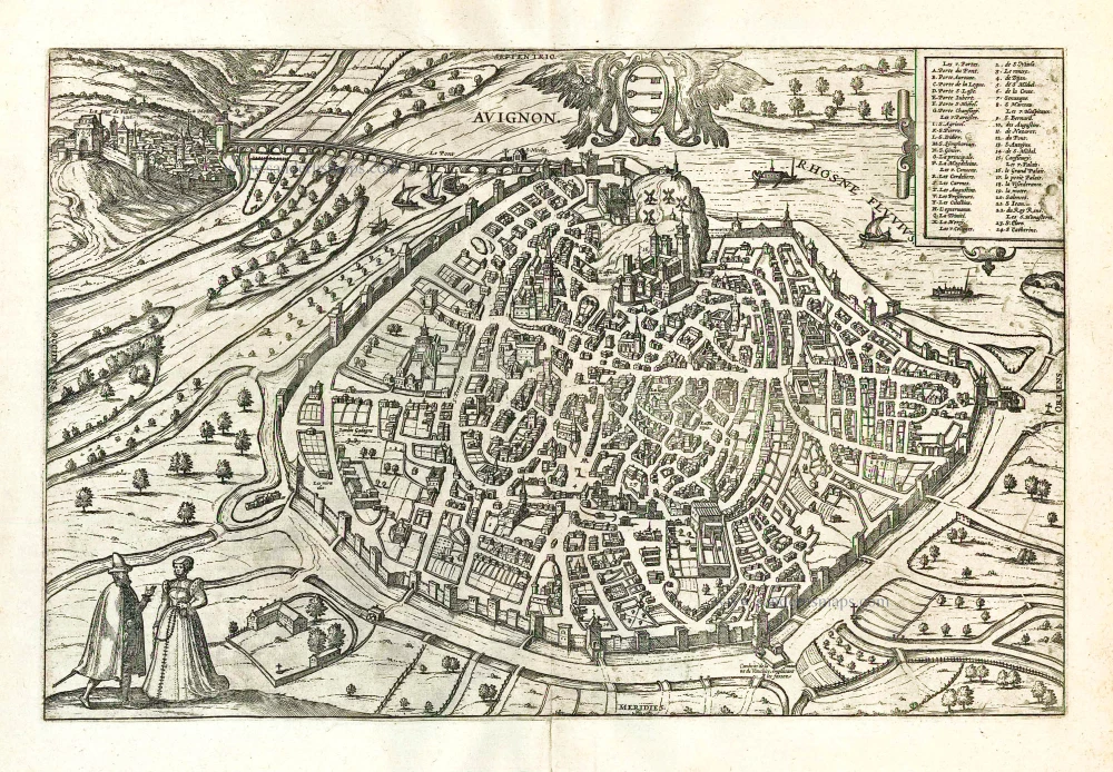
The engraving is a faithful copy of Belleforest's plan of 1575, except that the tops of each of the towers have been changed into gabled roofs by adding a crenellation.
COMMENTARY BY BRAUN: "Avignon is a highly famed city with a wonderful church in honour of the Virgin Mary, which enjoys many privileges. This city has a magnificent cardinal's palace and a veritable Carthusian monastery surpassing all others in France. The Roman Papacy had its seat in this city for 70 years. All around the city is good fertile soil, much silk is dyed here and there are also many paper mills due to its favourable location near the water. Not to be forgotten is the university, which flourished particularly during the time when the Pope had his seat here."
Avignon is shown from the south in a bird's-eye view almost resembling a plan. On the other side of the Rhône lies Villeneuve, the site of the Carthusian monastery mentioned by Braun, represented together with the adjoining hills in side view. Many of Avignon's medieval structures, such as the massive city walls, have been preserved. The cityscape is dominated by the Romanesque Notre Dame des Doms Cathedral dating from the 14th century. The Saint-Bénézet bridge, commemorated in the traditional French song "Sur le pont d'Avignon", dates from the 12th century. The plate shows the original bridge, almost completely destroyed by floods in 1668. In 1309-1376 Avignon was the residence of the popes during what is known as the Avignon exile. Up to 1797, Avignon remained in papal ownership. Silk-making was an important economic activity in Avignon. Remarkable are the four windmills that can be seen on some 60-m-high limestone bluff that rises up in the middle of the town.
Braun G. & Hogenberg F. and the Civitates Orbis Terrarum.
The Civitates Orbis Terrarum, also known as the 'Braun & Hogenberg', is a six-volume town atlas and the most excellent book of town views and plans ever published: 363 engravings, sometimes beautifully coloured. It was one of the best-selling works in the last quarter of the 16th century. Georg Braun, a skilled writer, wrote the text accompanying the plans and views on the verso. Many plates were engraved after the original drawings of a professional artist, Joris Hoefnagel (1542-1600). The first volume was published in Latin in 1572 and the sixth in 1617. Frans Hogenberg, a talented engraver, created the tables for volumes I through IV, and Simon van den Neuwel made those for volumes V and VI. Other contributors were cartographers Daniel Freese and Heinrich Rantzau, who provided valuable geographical information. Works by Jacob van Deventer, Sebastian Münster, and Johannes Stumpf were also used as references. Translations appeared in German and French, making the atlas accessible to a broader audience.
Since its original publication of volume 1 in 1572, the Civitates Orbis Terrarum has left an indelible mark on the history of cartography. Seven more editions followed the first volume in 1575, 1577, 1582, 1588, 1593, 1599, and 1612. Vol.2, initially released in 1575, saw subsequent editions in 1597 and 1612. The subsequent volumes, each a treasure trove of historical insights, graced the world in 1581, 1588, 1593, 1599, and 1606. The German translation of the first volume, a testament to its widespread appeal, debuted in 1574, followed by the French edition in 1575.
Several printers were involved: Theodor Graminaeus, Heinrich von Aich, Gottfried von Kempen, Johannis Sinniger, Bertram Buchholtz, and Peter von Brachel, all of whom worked in Cologne.
Georg Braun (1541-1622)
Georg Braun, the author of the text accompanying the plans and views in the Civitates Orbis Terrarum, was born in Cologne in 1541. After his studies in Cologne, he entered the Jesuit Order as a novice, indicating his commitment to learning and intellectual pursuits. In 1561, he obtained his bachelor's degree; in 1562, he received his Magister Artium, further demonstrating his academic achievements. Although he left the Jesuit Order, he continued his studies in theology, gaining a licentiate in theology. His theological background likely influenced the content and tone of the text in the Civitates Orbis Terrarum, adding a unique perspective to the work.
Frans Hogenberg (1535-1590)
Frans Hogenberg was a Flemish and German painter, engraver, and mapmaker. He was born in Mechelen as the son of Nicolaas Hogenberg.
By the end of the 1560s, Frans Hogenberg was employed upon Abraham Ortelius's Theatrum Orbis Terrarum, published in 1570; he is named an engraver of numerous maps. In 1568, he was banned from Antwerp by the Duke of Alva and travelled to London, where he stayed a few years before emigrating to Cologne. He immediately embarked on his two most important works, the Civitates, published in 1572 and the Geschichtsblätter, which appeared in several series from 1569 until about 1587.
Thanks to large-scale projects like the Geschichtsblätter and the Civitates, Hogenberg's social circumstances improved with each passing year. He died as a wealthy man in Cologne in 1590.
Avignon.
Item Number: 23967 Authenticity Guarantee
Category: Antique maps > Europe > France - Cities
Antique bird's-eye view plan of Avignon, by Georg Braun and Frans Hogenberg.
Vue à vol d'oiseau de la ville d'Avignon, par Georg Braun et Frans Hogenberg.
With key to locations.
Date of the first edition: 1575
Date of this map: 1597
Copper engraving, printed on paper.
Size (not including margins): 31 x 47cm (12.1 x 18.3 inches)
Verso text: Latin
Condition: Excellent.
Condition Rating: A+
References: Van der Krogt 4, #325; Fauser, #936; Taschen, Br. Hog., p.150.
From: Civitates Orbis Terrarum, ... Part 2: De Praecipuis, Totius Universi Urbibus, Liber Secundus. Köln, Bertram Buchholz, 1597. (Van der Krogt 4, 41:1.2)
The engraving is a faithful copy of Belleforest's plan of 1575, except that the tops of each of the towers have been changed into gabled roofs by adding a crenellation.
COMMENTARY BY BRAUN: "Avignon is a highly famed city with a wonderful church in honour of the Virgin Mary, which enjoys many privileges. This city has a magnificent cardinal's palace and a veritable Carthusian monastery surpassing all others in France. The Roman Papacy had its seat in this city for 70 years. All around the city is good fertile soil, much silk is dyed here and there are also many paper mills due to its favourable location near the water. Not to be forgotten is the university, which flourished particularly during the time when the Pope had his seat here."
Avignon is shown from the south in a bird's-eye view almost resembling a plan. On the other side of the Rhône lies Villeneuve, the site of the Carthusian monastery mentioned by Braun, represented together with the adjoining hills in side view. Many of Avignon's medieval structures, such as the massive city walls, have been preserved. The cityscape is dominated by the Romanesque Notre Dame des Doms Cathedral dating from the 14th century. The Saint-Bénézet bridge, commemorated in the traditional French song "Sur le pont d'Avignon", dates from the 12th century. The plate shows the original bridge, almost completely destroyed by floods in 1668. In 1309-1376 Avignon was the residence of the popes during what is known as the Avignon exile. Up to 1797, Avignon remained in papal ownership. Silk-making was an important economic activity in Avignon. Remarkable are the four windmills that can be seen on some 60-m-high limestone bluff that rises up in the middle of the town.
Braun G. & Hogenberg F. and the Civitates Orbis Terrarum.
The Civitates Orbis Terrarum, also known as the 'Braun & Hogenberg', is a six-volume town atlas and the most excellent book of town views and plans ever published: 363 engravings, sometimes beautifully coloured. It was one of the best-selling works in the last quarter of the 16th century. Georg Braun, a skilled writer, wrote the text accompanying the plans and views on the verso. Many plates were engraved after the original drawings of a professional artist, Joris Hoefnagel (1542-1600). The first volume was published in Latin in 1572 and the sixth in 1617. Frans Hogenberg, a talented engraver, created the tables for volumes I through IV, and Simon van den Neuwel made those for volumes V and VI. Other contributors were cartographers Daniel Freese and Heinrich Rantzau, who provided valuable geographical information. Works by Jacob van Deventer, Sebastian Münster, and Johannes Stumpf were also used as references. Translations appeared in German and French, making the atlas accessible to a broader audience.
Since its original publication of volume 1 in 1572, the Civitates Orbis Terrarum has left an indelible mark on the history of cartography. Seven more editions followed the first volume in 1575, 1577, 1582, 1588, 1593, 1599, and 1612. Vol.2, initially released in 1575, saw subsequent editions in 1597 and 1612. The subsequent volumes, each a treasure trove of historical insights, graced the world in 1581, 1588, 1593, 1599, and 1606. The German translation of the first volume, a testament to its widespread appeal, debuted in 1574, followed by the French edition in 1575.
Several printers were involved: Theodor Graminaeus, Heinrich von Aich, Gottfried von Kempen, Johannis Sinniger, Bertram Buchholtz, and Peter von Brachel, all of whom worked in Cologne.
Georg Braun (1541-1622)
Georg Braun, the author of the text accompanying the plans and views in the Civitates Orbis Terrarum, was born in Cologne in 1541. After his studies in Cologne, he entered the Jesuit Order as a novice, indicating his commitment to learning and intellectual pursuits. In 1561, he obtained his bachelor's degree; in 1562, he received his Magister Artium, further demonstrating his academic achievements. Although he left the Jesuit Order, he continued his studies in theology, gaining a licentiate in theology. His theological background likely influenced the content and tone of the text in the Civitates Orbis Terrarum, adding a unique perspective to the work.
Frans Hogenberg (1535-1590)
Frans Hogenberg was a Flemish and German painter, engraver, and mapmaker. He was born in Mechelen as the son of Nicolaas Hogenberg.
By the end of the 1560s, Frans Hogenberg was employed upon Abraham Ortelius's Theatrum Orbis Terrarum, published in 1570; he is named an engraver of numerous maps. In 1568, he was banned from Antwerp by the Duke of Alva and travelled to London, where he stayed a few years before emigrating to Cologne. He immediately embarked on his two most important works, the Civitates, published in 1572 and the Geschichtsblätter, which appeared in several series from 1569 until about 1587.
Thanks to large-scale projects like the Geschichtsblätter and the Civitates, Hogenberg's social circumstances improved with each passing year. He died as a wealthy man in Cologne in 1590.