
Important 16th century plan in excellent condition
Paris, by Georg Braun and Frans Hogenberg. 1582


TRANSLATION OF CARTOUCHE TEXT LEFT: Lutetia, commonly known as Paris, is the largest city in France and has the navigable Seine flowing around it. With the nobility, merchants, an excellent university, the stupendous church of Notre-Dame, the royal palace and other outstanding buildings, with a fair judiciary and most beautiful epitaphs, it is a most flourishing city.
CARTOUCHE RIGHT: Paris is truly a royal house / Of the god Apollo in his radiant splendour / Is like Cyrrea full of good minds / Vigorously it brings forth divers writings / Is like Chrysea abundant in metals / Almost like Greece flourishing in wisdom / The India of study and the Rome of poets / Athens, lastly, through famous scholars / Rosebush of the world, balsam of the firmament / Universal, the ornament of Sidon / Abundant in food and drink / Rich in lovely meadows and damp riverbanks / Fruitful in wine, mild for its citizens / Fertile in wheat and many other goods.
COMMENTARY BY BRAUN: "Paris is the capital of the most highly productive Kingdom of France, on account of its incredible size, the nobility, merchants and burghers, its number of students and its notable buildings. The city that lies between the University and the main town is connected to the University by two bridges and to the town proper by three, lined on both sides with houses. On this spot Philip the Fair built a royal palace, containing a little chapel constructed with wonderful skill. Here also is a magnificent church dedicated to Our Lady, which is considered a wonder of the whole of France on account of its wonderfully beautiful form, size and artistically skilful pictures."
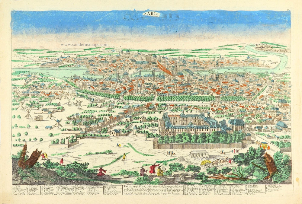
Paris is shown from a bird's-eye perspective. In the 16th century, under Henry IV, the city was transformed into a splendid capital; in the present engraving, however, this process has not yet begun. The urban layout within the city walls is illustrated very clearly, as is the Seine flowing around the Île de la Cité with the Sainte-Chapelle, the palace chapel. During the reign of Philip IV (Philip the Fair) the Tour d'Argent and Tour de César gatetowers and the Tour de l'Horloge clock tower were built. The city numered some 200,000 inhabitants. Just beyond the city wall at the top of the picture is the large Fort la Bastille. On a fictive hill three people clad in typical contemporary dress are shown from an idealized viewpoint. In the first half of the 16th century, France copied the stiff Spanish fashions: hence the man wears a Spanish cape with a stand-up collar and epaulettes over a padded doublet and hose, while the ladies wear corsets and close-fitting ruffs.
This plan is copied from the "Premier Plan" from c. 1530, which Sabastien Münster also used in a smaller representation for his Cosmographia, 1569. All the 16th-century representations of Paris are attributed to the "Premier Plan", which is supposed to have measured approximately 5 x 4 m and to have been made between 1523 and 1530. Two city gates that were built by Philip II, Augustus, in 1180 feature in the illustration, although they were demolished c. 1530. (Taschen)
Braun G. & Hogenberg F. and the Civitates Orbis Terrarum.
The Civitates Orbis Terrarum, also known as the 'Braun & Hogenberg', is a six-volume town atlas and the most excellent book of town views and plans ever published: 363 engravings, sometimes beautifully coloured. It was one of the best-selling works in the last quarter of the 16th century. Georg Braun, a skilled writer, wrote the text accompanying the plans and views on the verso. Many plates were engraved after the original drawings of a professional artist, Joris Hoefnagel (1542-1600). The first volume was published in Latin in 1572 and the sixth in 1617. Frans Hogenberg, a talented engraver, created the tables for volumes I through IV, and Simon van den Neuwel made those for volumes V and VI. Other contributors were cartographers Daniel Freese and Heinrich Rantzau, who provided valuable geographical information. Works by Jacob van Deventer, Sebastian Münster, and Johannes Stumpf were also used as references. Translations appeared in German and French, making the atlas accessible to a broader audience.
Since its original publication of volume 1 in 1572, the Civitates Orbis Terrarum has left an indelible mark on the history of cartography. Seven more editions followed the first volume in 1575, 1577, 1582, 1588, 1593, 1599, and 1612. Vol.2, initially released in 1575, saw subsequent editions in 1597 and 1612. The subsequent volumes, each a treasure trove of historical insights, graced the world in 1581, 1588, 1593, 1599, and 1606. The German translation of the first volume, a testament to its widespread appeal, debuted in 1574, followed by the French edition in 1575.
Several printers were involved: Theodor Graminaeus, Heinrich von Aich, Gottfried von Kempen, Johannis Sinniger, Bertram Buchholtz, and Peter von Brachel, all of whom worked in Cologne.
Georg Braun (1541-1622)
Georg Braun, the author of the text accompanying the plans and views in the Civitates Orbis Terrarum, was born in Cologne in 1541. After his studies in Cologne, he entered the Jesuit Order as a novice, indicating his commitment to learning and intellectual pursuits. In 1561, he obtained his bachelor's degree; in 1562, he received his Magister Artium, further demonstrating his academic achievements. Although he left the Jesuit Order, he continued his studies in theology, gaining a licentiate in theology. His theological background likely influenced the content and tone of the text in the Civitates Orbis Terrarum, adding a unique perspective to the work.
Frans Hogenberg (1535-1590)
Frans Hogenberg was a Flemish and German painter, engraver, and mapmaker. He was born in Mechelen as the son of Nicolaas Hogenberg.
By the end of the 1560s, Frans Hogenberg was employed upon Abraham Ortelius's Theatrum Orbis Terrarum, published in 1570; he is named an engraver of numerous maps. In 1568, he was banned from Antwerp by the Duke of Alva and travelled to London, where he stayed a few years before emigrating to Cologne. He immediately embarked on his two most important works, the Civitates, published in 1572 and the Geschichtsblätter, which appeared in several series from 1569 until about 1587.
Thanks to large-scale projects like the Geschichtsblätter and the Civitates, Hogenberg's social circumstances improved with each passing year. He died as a wealthy man in Cologne in 1590.
Lutetia vulgari Nomine Paris, Urbs Galliae Maxima, Sequana Navigabili Flumine Irrigatur ...
Item Number: 25675 Authenticity Guarantee
Category: Antique maps > Europe > France - Cities
Old, antique bird’s-eye view plan of Paris, by Georg Braun and Frans Hogenberg.
Title: Lutetia vulgari Nomine Paris, Urbs Galliae Maxima, Sequana Navigabili Flumine Irrigatur ...
Date of the first edition: 1572.
Date of this map: 1582.
Copper engraving, printed on paper.
Size (not including margins): 340 x 490mm (13.39 x 19.29 inches).
Verso: Latin text.
Condition: Original coloured, small printers crease at bottom centre.
Condition Rating: A.
From: Civitates Orbis Terrarum, Liber Primus. Köln, Gottfried von Kempen, 1582. (Van der Krogt 4, 41:1.1(1582))
TRANSLATION OF CARTOUCHE TEXT LEFT: Lutetia, commonly known as Paris, is the largest city in France and has the navigable Seine flowing around it. With the nobility, merchants, an excellent university, the stupendous church of Notre-Dame, the royal palace and other outstanding buildings, with a fair judiciary and most beautiful epitaphs, it is a most flourishing city.
CARTOUCHE RIGHT: Paris is truly a royal house / Of the god Apollo in his radiant splendour / Is like Cyrrea full of good minds / Vigorously it brings forth divers writings / Is like Chrysea abundant in metals / Almost like Greece flourishing in wisdom / The India of study and the Rome of poets / Athens, lastly, through famous scholars / Rosebush of the world, balsam of the firmament / Universal, the ornament of Sidon / Abundant in food and drink / Rich in lovely meadows and damp riverbanks / Fruitful in wine, mild for its citizens / Fertile in wheat and many other goods.
COMMENTARY BY BRAUN: "Paris is the capital of the most highly productive Kingdom of France, on account of its incredible size, the nobility, merchants and burghers, its number of students and its notable buildings. The city that lies between the University and the main town is connected to the University by two bridges and to the town proper by three, lined on both sides with houses. On this spot Philip the Fair built a royal palace, containing a little chapel constructed with wonderful skill. Here also is a magnificent church dedicated to Our Lady, which is considered a wonder of the whole of France on account of its wonderfully beautiful form, size and artistically skilful pictures."
Paris is shown from a bird's-eye perspective. In the 16th century, under Henry IV, the city was transformed into a splendid capital; in the present engraving, however, this process has not yet begun. The urban layout within the city walls is illustrated very clearly, as is the Seine flowing around the Île de la Cité with the Sainte-Chapelle, the palace chapel. During the reign of Philip IV (Philip the Fair) the Tour d'Argent and Tour de César gatetowers and the Tour de l'Horloge clock tower were built. The city numered some 200,000 inhabitants. Just beyond the city wall at the top of the picture is the large Fort la Bastille. On a fictive hill three people clad in typical contemporary dress are shown from an idealized viewpoint. In the first half of the 16th century, France copied the stiff Spanish fashions: hence the man wears a Spanish cape with a stand-up collar and epaulettes over a padded doublet and hose, while the ladies wear corsets and close-fitting ruffs.
This plan is copied from the "Premier Plan" from c. 1530, which Sabastien Münster also used in a smaller representation for his Cosmographia, 1569. All the 16th-century representations of Paris are attributed to the "Premier Plan", which is supposed to have measured approximately 5 x 4 m and to have been made between 1523 and 1530. Two city gates that were built by Philip II, Augustus, in 1180 feature in the illustration, although they were demolished c. 1530. (Taschen)
Braun G. & Hogenberg F. and the Civitates Orbis Terrarum.
The Civitates Orbis Terrarum, also known as the 'Braun & Hogenberg', is a six-volume town atlas and the most excellent book of town views and plans ever published: 363 engravings, sometimes beautifully coloured. It was one of the best-selling works in the last quarter of the 16th century. Georg Braun, a skilled writer, wrote the text accompanying the plans and views on the verso. Many plates were engraved after the original drawings of a professional artist, Joris Hoefnagel (1542-1600). The first volume was published in Latin in 1572 and the sixth in 1617. Frans Hogenberg, a talented engraver, created the tables for volumes I through IV, and Simon van den Neuwel made those for volumes V and VI. Other contributors were cartographers Daniel Freese and Heinrich Rantzau, who provided valuable geographical information. Works by Jacob van Deventer, Sebastian Münster, and Johannes Stumpf were also used as references. Translations appeared in German and French, making the atlas accessible to a broader audience.
Since its original publication of volume 1 in 1572, the Civitates Orbis Terrarum has left an indelible mark on the history of cartography. Seven more editions followed the first volume in 1575, 1577, 1582, 1588, 1593, 1599, and 1612. Vol.2, initially released in 1575, saw subsequent editions in 1597 and 1612. The subsequent volumes, each a treasure trove of historical insights, graced the world in 1581, 1588, 1593, 1599, and 1606. The German translation of the first volume, a testament to its widespread appeal, debuted in 1574, followed by the French edition in 1575.
Several printers were involved: Theodor Graminaeus, Heinrich von Aich, Gottfried von Kempen, Johannis Sinniger, Bertram Buchholtz, and Peter von Brachel, all of whom worked in Cologne.
Georg Braun (1541-1622)
Georg Braun, the author of the text accompanying the plans and views in the Civitates Orbis Terrarum, was born in Cologne in 1541. After his studies in Cologne, he entered the Jesuit Order as a novice, indicating his commitment to learning and intellectual pursuits. In 1561, he obtained his bachelor's degree; in 1562, he received his Magister Artium, further demonstrating his academic achievements. Although he left the Jesuit Order, he continued his studies in theology, gaining a licentiate in theology. His theological background likely influenced the content and tone of the text in the Civitates Orbis Terrarum, adding a unique perspective to the work.
Frans Hogenberg (1535-1590)
Frans Hogenberg was a Flemish and German painter, engraver, and mapmaker. He was born in Mechelen as the son of Nicolaas Hogenberg.
By the end of the 1560s, Frans Hogenberg was employed upon Abraham Ortelius's Theatrum Orbis Terrarum, published in 1570; he is named an engraver of numerous maps. In 1568, he was banned from Antwerp by the Duke of Alva and travelled to London, where he stayed a few years before emigrating to Cologne. He immediately embarked on his two most important works, the Civitates, published in 1572 and the Geschichtsblätter, which appeared in several series from 1569 until about 1587.
Thanks to large-scale projects like the Geschichtsblätter and the Civitates, Hogenberg's social circumstances improved with each passing year. He died as a wealthy man in Cologne in 1590.
Related items

Ager Parisiensis Vulgo L'Isle de France 1635
Ile de France by Blaeu W. & J.
[Item number: 22802]

Paris. 1658/60
Paris, by P.H. Schut, published by N. Visscher.
[Item number: 26631]
Rare
Paris, Lutetia, Paritij, Ville Capitale du Royaume de France, et la principale de l'Europe ... c. 1780
Paris by Pierre Aveline, published in Paris by Jean.
[Item number: 28753]

Veüe et Perspective du College des 4 Nations. 1728
View of Paris - Collège des Quatre-Nations, by Pieter Van der Aa.
[Item number: 31438]

La Porte St. Bernard. 1728
View of Paris - Collège des Quatre-Nations, by Pieter Van der Aa.
[Item number: 31439]

La Porte de la Conference 1728
View of Paris - Porte de la Conference, by Pieter Van der Aa.
[Item number: 31441]

La Porte St. Martin 1728
View of Paris - Porte St. Martin, by Pieter Van der Aa.
[Item number: 31442]

La Nouvelle Porte St. Honoré [...] Le Dôme des Filles de Lassomption. 1728
View of Paris - Porte St. Honoré & Dôme des Filles de Lassomption.
[Item number: 31443]

Vue de la Sortie de Paris prise du Pont Neuf. c. 1750
Optical View of Paris, by Martin Engelbrecht.
[Item number: 31910]

Optical View
l'Eglise de Notre Dame à Paris - Die Kirche Unser Lieben Frauen zu Paris. c. 1750
Notre Dame of Paris, by Martin Engelbrecht.
[Item number: 31919]

Optical View
La Place Dauphine du Cote du Pont neuf à Paris - Place des Dauphins von der Seite der neuen Brücke zu Paris. c. 1750
Place Dauphine of Paris, by Martin Engelbrecht.
[Item number: 31920]

Optical view
Veuë et perspective de l'hostelle de Ville à Paris. - Perspectivische Vorstellung des Rathhauses zu Paris. c. 1750
City Hall of Paris, by Martin Engelbrecht.
[Item number: 31921]

Optical View
La Porte S. Antoine à Paris. - Das Thor des Heil. Antonii zu Paris. c. 1750
Porte St. Antoine of Paris, by Martin Engelbrecht.
[Item number: 31922]

Superb colouring
Le Plan de Paris, ses Faubourgs et ses Environs, divisé suivant ses Meridiens et Paralells par Minutes et Secondes. 1631-1641
Paris, by Matthaeus Seutter
[Item number: 32538]

Spectacular 17th century view
Parys. 1638
Paris by Matthäus Merian
[Item number: 33022]