
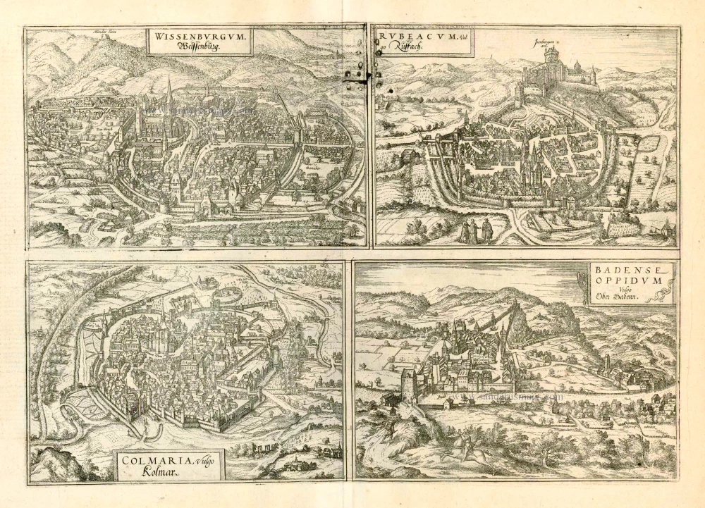
Wissembourg, Rouffach, Colmar, Baden in Aargau, by Georg Braun and Frans Hogenberg. 1597
Braun G. & Hogenberg F. and the Civitates Orbis Terrarum.
The Civitates Orbis Terrarum, also known as the 'Braun & Hogenberg', is a six-volume town atlas and the most excellent book of town views and plans ever published: 363 engravings, sometimes beautifully coloured. It was one of the best-selling works in the last quarter of the 16th century. Georg Braun, a skilled writer, wrote the text accompanying the plans and views on the verso. Many plates were engraved after the original drawings of a professional artist, Joris Hoefnagel (1542-1600). The first volume was published in Latin in 1572 and the sixth in 1617. Frans Hogenberg, a talented engraver, created the tables for volumes I through IV, and Simon van den Neuwel made those for volumes V and VI. Other contributors were cartographers Daniel Freese and Heinrich Rantzau, who provided valuable geographical information. Works by Jacob van Deventer, Sebastian Münster, and Johannes Stumpf were also used as references. Translations appeared in German and French, making the atlas accessible to a broader audience.
Since its original publication of volume 1 in 1572, the Civitates Orbis Terrarum has left an indelible mark on the history of cartography. Seven more editions followed the first volume in 1575, 1577, 1582, 1588, 1593, 1599, and 1612. Vol.2, initially released in 1575, saw subsequent editions in 1597 and 1612. The subsequent volumes, each a treasure trove of historical insights, graced the world in 1581, 1588, 1593, 1599, and 1606. The German translation of the first volume, a testament to its widespread appeal, debuted in 1574, followed by the French edition in 1575.
Several printers were involved: Theodor Graminaeus, Heinrich von Aich, Gottfried von Kempen, Johannis Sinniger, Bertram Buchholtz, and Peter von Brachel, all of whom worked in Cologne.
Georg Braun (1541-1622)
Georg Braun, the author of the text accompanying the plans and views in the Civitates Orbis Terrarum, was born in Cologne in 1541. After his studies in Cologne, he entered the Jesuit Order as a novice, indicating his commitment to learning and intellectual pursuits. In 1561, he obtained his bachelor's degree; in 1562, he received his Magister Artium, further demonstrating his academic achievements. Although he left the Jesuit Order, he continued his studies in theology, gaining a licentiate in theology. His theological background likely influenced the content and tone of the text in the Civitates Orbis Terrarum, adding a unique perspective to the work.
Frans Hogenberg (1535-1590)
Frans Hogenberg was a Flemish and German painter, engraver, and mapmaker. He was born in Mechelen as the son of Nicolaas Hogenberg.
By the end of the 1560s, Frans Hogenberg was employed upon Abraham Ortelius's Theatrum Orbis Terrarum, published in 1570; he is named an engraver of numerous maps. In 1568, he was banned from Antwerp by the Duke of Alva and travelled to London, where he stayed a few years before emigrating to Cologne. He immediately embarked on his two most important works, the Civitates, published in 1572 and the Geschichtsblätter, which appeared in several series from 1569 until about 1587.
Thanks to large-scale projects like the Geschichtsblätter and the Civitates, Hogenberg's social circumstances improved with each passing year. He died as a wealthy man in Cologne in 1590.
Wissenburgum. Weissenburg [on sheet with] Rubeacum, Vulgo Russach [and] Colmaria, vulgo Kolmar [and] Badense Oppidum Vulgo Ober Badenn.
Item Number: 23990 Authenticity Guarantee
Category: Antique maps > Europe > France - Cities
Old, antique map with four bird's-eye view plans by Braun and Hogenberg: Wissembourg, Rouffach, Colmar, Baden in Aargau.
The four views are engraved after woodcuts published in Münster's Cosmographia, 1550.
WISSEMBOURG
COMMENTARY BY BRAUN: "Wissembourg is an old imperial city, and possesses an excellent, good wine, which is almost the only source of income for the burghers of Wissembourg and other nearby small towns; because of its high quality the wine is fetched from a great distance by foreign carters and exported as far as Swabia, Bavaria, Brabant and the Netherlands."
This near bird's-eye view of the city of Wissembourg gives a detailed impression of the layout of this Free Imperial City (1306-1697), which has preserved its medieval character up to today; it is dominated by the abbey church of Saint-Pierre-et Saint-Paul, a Gothic building with a Romanesque bell tower. Behind it to the right in the plate is the 15th-century Gothic parish church of Saint-Jean. The next biggest building to the right of the town hall was built in 1506 and served up to the 18th century as a stagecoach post where the horses were changed.The Mundat Stein (top left) marks the boundary of the area received by the Wissembourg monastery in the 8th century as a gift from Pippin the Short. (Mundat is a legal term, derived from the Latin immunitas, marking an area with its own jurisdiction).
ROUFFACH
CARTOUCHE: Rubeacum, in the vernacular Rouffach.
COMMENTARY BY BRAUN: "Rouffach really is a very old town that was first erected by the Romans. The town had fine buildings and suburbs and was favoured by the nobility because of the great fertility of the farmland, which meant that all the necessities of life could be had here. But nothing on this earth is constant and everything goes up and down according to good luck and misfortune, so that the town of Rouffach, too, has suffered misfortune several times during its 1,000 years of felicity."
This view in cavalier perspetive shows the small Alsatian town of Rouffach, which in the Middle Ages was the residence of the Merovingian kings and was then given to the archbishopric of Strasbourg as a gift. We can clearly see the church of Notre-Dame de l'Assomption, built in yellow sandstone, on the left the church and monastery of the Franciscans (Fratres Minores) and, below the castle of Isenbourg, the so-called Witch Tower, a jail dating from the 13th to the 15th century. As the chief town of the archiepiscopal fief, Rouffach quickly became a wealthy city. Its prosperity ended with the Thirty Years' War, for the Swedes destroyed Rouffach irreparably.
COLMAR
CARTOUCHE: Colmaria, in German Colmar
COMMENTARY BY BRAUN: "Colmar lies on fertile soil, for vines and corn grow there. The city is in the middle of Alsace, one mile away from Kaiserberg, Ammersweiler, Reichenweier and Rappoltsweiler, where the best vineyards in the Alsace are found."
This view in cavalier perspective shows the vineyards surrounding Colmar and the layout of the city. Large parts of its medieval silhouette are still preserved today. The church labelled Summum Templum is the Gothic parish church of St Martin, which, with its 71-m-high tower, rises above all other buildings in Colmar. To the left of the parish church is the 13th-century Dominican church. By 1575 the Reformation made its way to Colmar. Colmar grew out of a Carolingian royal court. It was granted market and city rights in the early 13th century, and from 1282 onwards it was extended to become one of the mightiest fortresses in the Empire; the fortifications, which can be seen here, have partially been preserved and today form promenades in the inner city.
BADEN IN AARGAU
CARTOUCHE: The town of Oppidum Badense, in German Baden.
COMMENTARY BY BRAUN: "This town was known and inhabited at the time of Tacitus and even long before; he described it in these words: It is said to be a charming town with beneficial hot-spring water and a fortified castle on the Limmat. Today Baden is a small town with two castles or fortresses, although the upper castle is ruined. [...] There are over 30 different baths, in which even the common man and the peasants can bathe."
View of the little town of Baden in Aargau from the far side of the Limmat. On the far right is the spa with the sulphur springs that have been known since Roman times as Vicus Aqua Helveticae, or Badenia. Visible are the 15th-century tower (with the city wall to its right) and the medieval castle on the hill (Arx), built in the 11the century by the Counts of Lenzburg. At the end of the bridge is the bailiff's castle, which at the time of Braun and Hogenberg was the official residence of the Confederate governor of Baden. At the foot of the castle hill lies the late Gothic parish church of St Mary's Assumption. In a public disputation on the Reformation in 1526 the citizens of Baden decided in favour of Catholicism. (Taschen)
Date of the first edition: 1575
Date of this map: 1597
Copper engraving - the top centre of the copperplate shows a repair with 16 nails.
Size: 33.5 x 47.5cm (13 x 18.6 inches)
Verso text: Latin
Condition: Old coloured, excellent.
Condition Rating: A
References: Van der Krogt 4, 4855; Taschen, Braun and Hogenberg, p.173.
From: Civitates Orbis Terrarum, ... Part 2: De Praecipuis, Totius Universi Urbibus, Liber Secundus. Köln, Bertram Buchholz, 1597. (Van der Krogt 4, 41:1.2)
Braun G. & Hogenberg F. and the Civitates Orbis Terrarum.
The Civitates Orbis Terrarum, also known as the 'Braun & Hogenberg', is a six-volume town atlas and the most excellent book of town views and plans ever published: 363 engravings, sometimes beautifully coloured. It was one of the best-selling works in the last quarter of the 16th century. Georg Braun, a skilled writer, wrote the text accompanying the plans and views on the verso. Many plates were engraved after the original drawings of a professional artist, Joris Hoefnagel (1542-1600). The first volume was published in Latin in 1572 and the sixth in 1617. Frans Hogenberg, a talented engraver, created the tables for volumes I through IV, and Simon van den Neuwel made those for volumes V and VI. Other contributors were cartographers Daniel Freese and Heinrich Rantzau, who provided valuable geographical information. Works by Jacob van Deventer, Sebastian Münster, and Johannes Stumpf were also used as references. Translations appeared in German and French, making the atlas accessible to a broader audience.
Since its original publication of volume 1 in 1572, the Civitates Orbis Terrarum has left an indelible mark on the history of cartography. Seven more editions followed the first volume in 1575, 1577, 1582, 1588, 1593, 1599, and 1612. Vol.2, initially released in 1575, saw subsequent editions in 1597 and 1612. The subsequent volumes, each a treasure trove of historical insights, graced the world in 1581, 1588, 1593, 1599, and 1606. The German translation of the first volume, a testament to its widespread appeal, debuted in 1574, followed by the French edition in 1575.
Several printers were involved: Theodor Graminaeus, Heinrich von Aich, Gottfried von Kempen, Johannis Sinniger, Bertram Buchholtz, and Peter von Brachel, all of whom worked in Cologne.
Georg Braun (1541-1622)
Georg Braun, the author of the text accompanying the plans and views in the Civitates Orbis Terrarum, was born in Cologne in 1541. After his studies in Cologne, he entered the Jesuit Order as a novice, indicating his commitment to learning and intellectual pursuits. In 1561, he obtained his bachelor's degree; in 1562, he received his Magister Artium, further demonstrating his academic achievements. Although he left the Jesuit Order, he continued his studies in theology, gaining a licentiate in theology. His theological background likely influenced the content and tone of the text in the Civitates Orbis Terrarum, adding a unique perspective to the work.
Frans Hogenberg (1535-1590)
Frans Hogenberg was a Flemish and German painter, engraver, and mapmaker. He was born in Mechelen as the son of Nicolaas Hogenberg.
By the end of the 1560s, Frans Hogenberg was employed upon Abraham Ortelius's Theatrum Orbis Terrarum, published in 1570; he is named an engraver of numerous maps. In 1568, he was banned from Antwerp by the Duke of Alva and travelled to London, where he stayed a few years before emigrating to Cologne. He immediately embarked on his two most important works, the Civitates, published in 1572 and the Geschichtsblätter, which appeared in several series from 1569 until about 1587.
Thanks to large-scale projects like the Geschichtsblätter and the Civitates, Hogenberg's social circumstances improved with each passing year. He died as a wealthy man in Cologne in 1590.
Related items
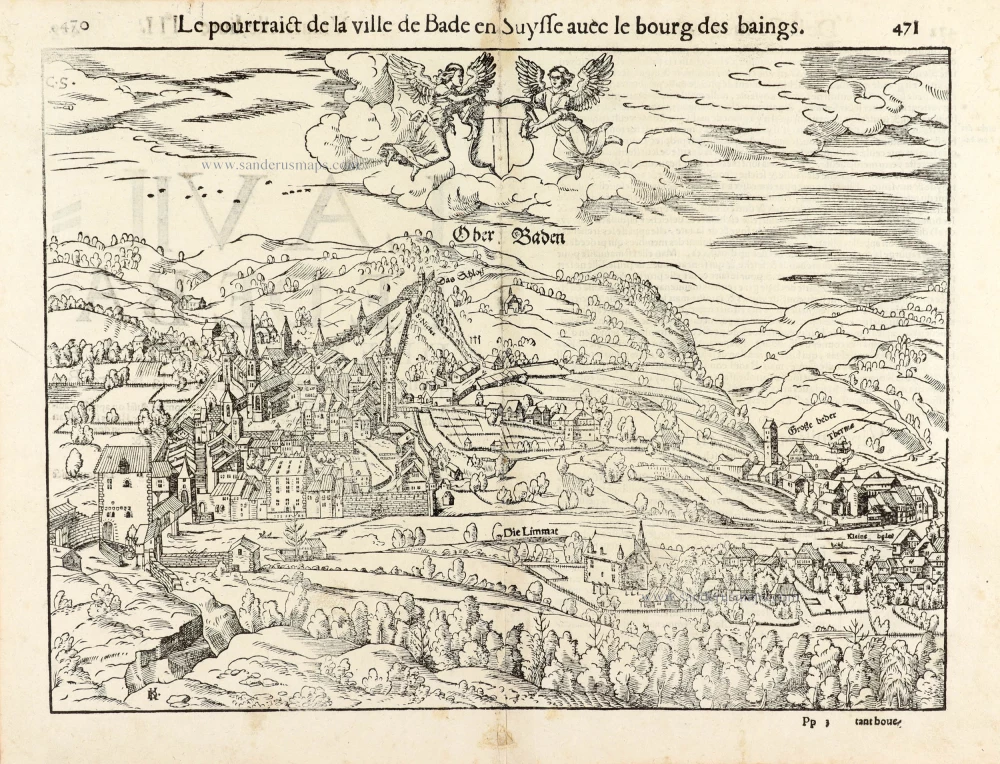
Le pourtraict de la ville de Bade en Suysse avec le bourg des baings. - Ober Baden. 1568
Baden im Aargau by Sebastian Münster.
[Item number: 30598]
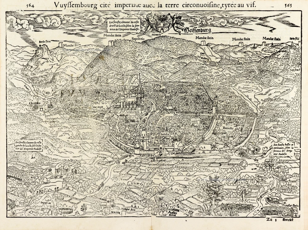
Vuyssembourg cité imperiale avec la terre circonvoisine, tyrée au vif. - Weissenburg. 1568
Wissembourg by Sebastian Münster.
[Item number: 30599]