
Dunkerque, Gravelines and Bourbourg, by Georg Braun and Frans Hogenberg. 1597

Braun G. & Hogenberg F. and the Civitates Orbis Terrarum.
The Civitates Orbis Terrarum, also known as the 'Braun & Hogenberg', is a six-volume town atlas and the most excellent book of town views and plans ever published: 363 engravings, sometimes beautifully coloured. It was one of the best-selling works in the last quarter of the 16th century. Georg Braun, a skilled writer, wrote the text accompanying the plans and views on the verso. Many plates were engraved after the original drawings of a professional artist, Joris Hoefnagel (1542-1600). The first volume was published in Latin in 1572 and the sixth in 1617. Frans Hogenberg, a talented engraver, created the tables for volumes I through IV, and Simon van den Neuwel made those for volumes V and VI. Other contributors were cartographers Daniel Freese and Heinrich Rantzau, who provided valuable geographical information. Works by Jacob van Deventer, Sebastian Münster, and Johannes Stumpf were also used as references. Translations appeared in German and French, making the atlas accessible to a broader audience.
Since its original publication of volume 1 in 1572, the Civitates Orbis Terrarum has left an indelible mark on the history of cartography. Seven more editions followed the first volume in 1575, 1577, 1582, 1588, 1593, 1599, and 1612. Vol.2, initially released in 1575, saw subsequent editions in 1597 and 1612. The subsequent volumes, each a treasure trove of historical insights, graced the world in 1581, 1588, 1593, 1599, and 1606. The German translation of the first volume, a testament to its widespread appeal, debuted in 1574, followed by the French edition in 1575.
Several printers were involved: Theodor Graminaeus, Heinrich von Aich, Gottfried von Kempen, Johannis Sinniger, Bertram Buchholtz, and Peter von Brachel, all of whom worked in Cologne.
Georg Braun (1541-1622)
Georg Braun, the author of the text accompanying the plans and views in the Civitates Orbis Terrarum, was born in Cologne in 1541. After his studies in Cologne, he entered the Jesuit Order as a novice, indicating his commitment to learning and intellectual pursuits. In 1561, he obtained his bachelor's degree; in 1562, he received his Magister Artium, further demonstrating his academic achievements. Although he left the Jesuit Order, he continued his studies in theology, gaining a licentiate in theology. His theological background likely influenced the content and tone of the text in the Civitates Orbis Terrarum, adding a unique perspective to the work.
Frans Hogenberg (1535-1590)
Frans Hogenberg was a Flemish and German painter, engraver, and mapmaker. He was born in Mechelen as the son of Nicolaas Hogenberg.
By the end of the 1560s, Frans Hogenberg was employed upon Abraham Ortelius's Theatrum Orbis Terrarum, published in 1570; he is named an engraver of numerous maps. In 1568, he was banned from Antwerp by the Duke of Alva and travelled to London, where he stayed a few years before emigrating to Cologne. He immediately embarked on his two most important works, the Civitates, published in 1572 and the Geschichtsblätter, which appeared in several series from 1569 until about 1587.
Thanks to large-scale projects like the Geschichtsblätter and the Civitates, Hogenberg's social circumstances improved with each passing year. He died as a wealthy man in Cologne in 1590.
Duynkercke [on sheet with] Grevelinge [and] Borborch
Item Number: 23977 Authenticity Guarantee
Category: Antique maps > Europe > France - Cities
Old, antique map with three bird's-eye views by Braun and Hogenberg: Dunkerque, Gravelines and Bourbourg.
DUNKIRK (DUNKERQUE)
COMMENTARY BY BRAUN: "The city was built and encompassed by a circular wall by the inhabitants in a few years. It was constructed because of the favourable harbour, for ships can land here very easily and many inhabitants are therefore engaged in trade."
The prospect over the harbour refers the viewer immediately to the town's beginning as a fishing village in the 7th century. The settlement developed from a chapel built by St Eligius on the dunes, hence its name. Because of its position, Dunkirk was often fought over. In 1558 it fell to the French, who, however, gave the city back to the Spanish in the Peace of Cateau-Cambrésis in 1559. The unstable political conditions made Dunkirk a favourite port for pirates, who plundered ships in the North Sea. The belfry (right) stands out clearly, as does the 15th-century chapel of Notre-Dame-des-Dunes and the 16th-century church of Saint-Éloy, a five-nave hall church.
GRAVELINES
COMMENTARY BY BRAUN: "Gravelines is a little town in a coastal hinterland, situated on the River Aa halfway between Calais and Dunkirk, and was once famous because of its big, spacious harbour. But it has lost its former beauty due to the tyranny of the Normans and repeated attacks by the French. The inhabitants have now proteced the town from enemies with a broad moat and strong walls."
The bird's-eye view shows the fortress of Gravelines, situated to the east of Calais. Founded around 1160, it experienced considerable growth in the 12/13th centuries, thanks to the diversion of the Aa. Due to the silting up of the river, this period of prosperity came to an end after 200 years. Owing to its geographical position as gateway to the Netherlands, it was several times the scene of armed conflicts. The residents of Gravelines were thus eyewitnesses of the famous battle in which the English fleet under Sir Francis Drake defeated the Spanish Armada (1588). The medieval tower on the market square is today preserved as a belfry. The castle in the upper left-hand corner is part of the fortifications begun by Charles V in 1528.
BOURBOURG
COMMENTARY BY BRAUN: "Bourbourg is a little town, fortified with only one moat, a small earthern rampart and a wooden stockade. Nevertheless it caused the French much trouble for a long time, when it was in the possession of the English."
Bourbourg is shown here in cavalier perspective. The church of Saint Jean Baptiste stands out clearly. It houses the reliquary La Châsse de Notre-Dame de Bourbourg, which goes back to the 15th century. The town is first mentioned in a document in 987 as Broecborc, and is described as a marsh town. (Taschen)
Date of the first edition: 1575
Date of this map: 1597
Copper engraving
Size: 30 x 48.5cm (11.7 x 18.9 inches)
Verso text: Latin
Condition: Uncoloured, excellent.
Condition Rating: A
References: Van der Krogt 4, 1168; Taschen, Braun and Hogenberg, p.162.
From: Civitates Orbis Terrarum, ... Part 2: De Praecipuis, Totius Universi Urbibus, Liber Secundus. Köln, Bertram Buchholz, 1597. (Van der Krogt 4, 41:1.2)
Braun G. & Hogenberg F. and the Civitates Orbis Terrarum.
The Civitates Orbis Terrarum, also known as the 'Braun & Hogenberg', is a six-volume town atlas and the most excellent book of town views and plans ever published: 363 engravings, sometimes beautifully coloured. It was one of the best-selling works in the last quarter of the 16th century. Georg Braun, a skilled writer, wrote the text accompanying the plans and views on the verso. Many plates were engraved after the original drawings of a professional artist, Joris Hoefnagel (1542-1600). The first volume was published in Latin in 1572 and the sixth in 1617. Frans Hogenberg, a talented engraver, created the tables for volumes I through IV, and Simon van den Neuwel made those for volumes V and VI. Other contributors were cartographers Daniel Freese and Heinrich Rantzau, who provided valuable geographical information. Works by Jacob van Deventer, Sebastian Münster, and Johannes Stumpf were also used as references. Translations appeared in German and French, making the atlas accessible to a broader audience.
Since its original publication of volume 1 in 1572, the Civitates Orbis Terrarum has left an indelible mark on the history of cartography. Seven more editions followed the first volume in 1575, 1577, 1582, 1588, 1593, 1599, and 1612. Vol.2, initially released in 1575, saw subsequent editions in 1597 and 1612. The subsequent volumes, each a treasure trove of historical insights, graced the world in 1581, 1588, 1593, 1599, and 1606. The German translation of the first volume, a testament to its widespread appeal, debuted in 1574, followed by the French edition in 1575.
Several printers were involved: Theodor Graminaeus, Heinrich von Aich, Gottfried von Kempen, Johannis Sinniger, Bertram Buchholtz, and Peter von Brachel, all of whom worked in Cologne.
Georg Braun (1541-1622)
Georg Braun, the author of the text accompanying the plans and views in the Civitates Orbis Terrarum, was born in Cologne in 1541. After his studies in Cologne, he entered the Jesuit Order as a novice, indicating his commitment to learning and intellectual pursuits. In 1561, he obtained his bachelor's degree; in 1562, he received his Magister Artium, further demonstrating his academic achievements. Although he left the Jesuit Order, he continued his studies in theology, gaining a licentiate in theology. His theological background likely influenced the content and tone of the text in the Civitates Orbis Terrarum, adding a unique perspective to the work.
Frans Hogenberg (1535-1590)
Frans Hogenberg was a Flemish and German painter, engraver, and mapmaker. He was born in Mechelen as the son of Nicolaas Hogenberg.
By the end of the 1560s, Frans Hogenberg was employed upon Abraham Ortelius's Theatrum Orbis Terrarum, published in 1570; he is named an engraver of numerous maps. In 1568, he was banned from Antwerp by the Duke of Alva and travelled to London, where he stayed a few years before emigrating to Cologne. He immediately embarked on his two most important works, the Civitates, published in 1572 and the Geschichtsblätter, which appeared in several series from 1569 until about 1587.
Thanks to large-scale projects like the Geschichtsblätter and the Civitates, Hogenberg's social circumstances improved with each passing year. He died as a wealthy man in Cologne in 1590.
Related items
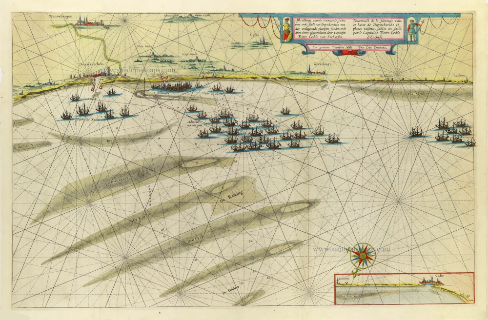
Afbeeldinge vande vermaerde seehaven ende stadt van Duynkercken ... | Pourtraict de la fameuse ville et havre de Duynckerck et places voisines, sables etc... 1647-50
Roadstead of Dunkerque by Blaeu W. & J.
[Item number: 13895]
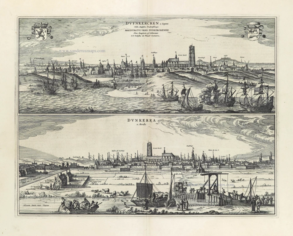
Duynkercken a Septent. - Dunkerka a Meridie. 1652
Dunkerque by Antonius Sanderus, published by Joan Blaeu.
[Item number: 28542]
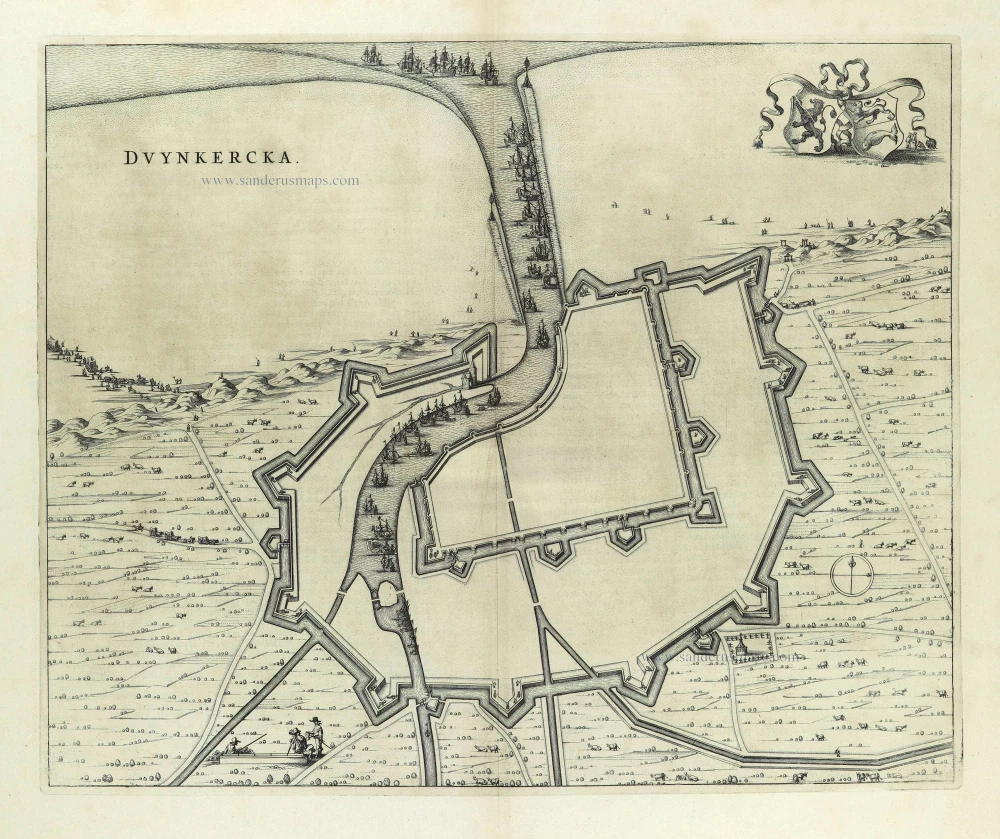
Duynkercka. 1652
Fortification plan of Dunkerque by Antonius Sanderus, published by Joan Blaeu.
[Item number: 28543]

Gravelines. 2nd half 17th century
Manuscript plan of Gravelines, a fortified city of strategic military significance.
[Item number: 30129]

Duijnkerken. 1612
Dunkerque (Duinkerke) by Guicciardini Lodovico
[Item number: 33015]