
Mâcon and Chalon-sur-Saône, by Georg Braun and Frans Hogenberg. 1588-97


MÂCON
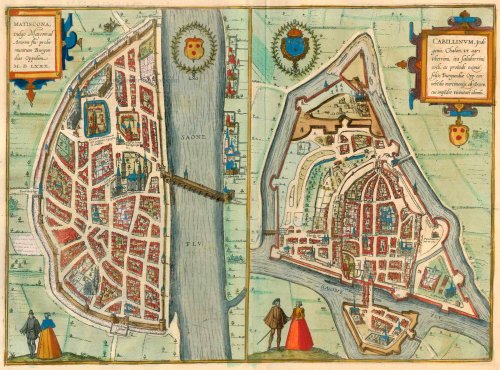
TRANSLATION OF CARTOUCHE TEXT: Matiscona, in French Mascon. On the River Arar. Well-fortified Burgundian town, 1580.
COMMENTARY BY BRAUN: "There is so little to be found about this town in the old chronicles that even if we can ascertain its age from Caesar, still we know nothing about its origin. We also know nothing about how it was rebuilt after being destroyed by Lothar, but only what still remains from the last reconstruction. This took place under Philip Augustus in the year 1222, when its citizens began to encircle it with stone walls and to fortify it with ramparts and bastions against attack by raiders. They added six more gates and adorned the town with magnificent churches."
This is a bird's-eye view of the fortified town on the left bank of the Saône, with north at the top. Occupying a prominent position, the Saint-Laurent bridge, with its characteristic arches, leads to the cathedral of Vieux Saint-Vincent. This replaced a bishop's church destroyed in the 10th century, which in its turn had been erected on the site of an ancient temple of Mercury. In AD 536 Mâcon became an episcopal see; the bishop's palace can be seen to the north of the old cathedral. In the 13th century Mâcon became the main residence of the Counts of Burgundy, and the city wall was built in the course of the fortification of the town under King Philip II.
CHALON-SUR-SAÔNE
CARTOUCHE: Cabillonum, in the local tongue Chalon. The land is fertile and the climate salubrious. Chalon is an exceptionally fortunate town on account of its trading of merchantise, for which it is well suited due to the proximity of the Arar, on which it is built.
COMMENTARY BY BRAUN: "That the town of Chalon near Mâcon - formerly in the province of Lugdunensis and now in the Duchy of Burgundy in France and known as Chalon-sur-Saône - is very old, can be gathered from Caesar, who gave an account of its location in the territory of the Haedui on the River Arar. A bishop's church dedicated to St Stephen was consecrated there, which was rebuilt by Childeric, the first king of the Franks, after he found it in ruins. And he granted it many privileges, after bringing the relics of St Vincent here from Spain. For this reason the name of the church was changed from St Stephen to St Vincent."
This bird's-eye view from the north shows the town on the Saône fortified by ramparts and a moat. On the western edge of the Old Town centre is the cathedral of Saint-Vincent. The town was Frankish from AD 534 and an episcopal see from the late 5th century onwards. To the south can be seen the abbey of Saint-Pierre, which was fortified in the 12th and 13th centuries and made into a citadel in 1563. On the north bank of the Saône lies the suburb of Saint-Laurent with a hospital dating from the 16th century. Due to its favourable location, the Roman town of Cabillonum was an important inland port. (Taschen)
The two views are made after views published by Belleforest in his La Cosmographie universelle. Paris, 1575.
Braun G. & Hogenberg F. and the Civitates Orbis Terrarum.
The Civitates Orbis Terrarum, also known as the 'Braun & Hogenberg', is a six-volume town atlas and the most excellent book of town views and plans ever published: 363 engravings, sometimes beautifully coloured. It was one of the best-selling works in the last quarter of the 16th century. Georg Braun, a skilled writer, wrote the text accompanying the plans and views on the verso. Many plates were engraved after the original drawings of a professional artist, Joris Hoefnagel (1542-1600). The first volume was published in Latin in 1572 and the sixth in 1617. Frans Hogenberg, a talented engraver, created the tables for volumes I through IV, and Simon van den Neuwel made those for volumes V and VI. Other contributors were cartographers Daniel Freese and Heinrich Rantzau, who provided valuable geographical information. Works by Jacob van Deventer, Sebastian Münster, and Johannes Stumpf were also used as references. Translations appeared in German and French, making the atlas accessible to a broader audience.
Since its original publication of volume 1 in 1572, the Civitates Orbis Terrarum has left an indelible mark on the history of cartography. Seven more editions followed the first volume in 1575, 1577, 1582, 1588, 1593, 1599, and 1612. Vol.2, initially released in 1575, saw subsequent editions in 1597 and 1612. The subsequent volumes, each a treasure trove of historical insights, graced the world in 1581, 1588, 1593, 1599, and 1606. The German translation of the first volume, a testament to its widespread appeal, debuted in 1574, followed by the French edition in 1575.
Several printers were involved: Theodor Graminaeus, Heinrich von Aich, Gottfried von Kempen, Johannis Sinniger, Bertram Buchholtz, and Peter von Brachel, all of whom worked in Cologne.
Georg Braun (1541-1622)
Georg Braun, the author of the text accompanying the plans and views in the Civitates Orbis Terrarum, was born in Cologne in 1541. After his studies in Cologne, he entered the Jesuit Order as a novice, indicating his commitment to learning and intellectual pursuits. In 1561, he obtained his bachelor's degree; in 1562, he received his Magister Artium, further demonstrating his academic achievements. Although he left the Jesuit Order, he continued his studies in theology, gaining a licentiate in theology. His theological background likely influenced the content and tone of the text in the Civitates Orbis Terrarum, adding a unique perspective to the work.
Frans Hogenberg (1535-1590)
Frans Hogenberg was a Flemish and German painter, engraver, and mapmaker. He was born in Mechelen as the son of Nicolaas Hogenberg.
By the end of the 1560s, Frans Hogenberg was employed upon Abraham Ortelius's Theatrum Orbis Terrarum, published in 1570; he is named an engraver of numerous maps. In 1568, he was banned from Antwerp by the Duke of Alva and travelled to London, where he stayed a few years before emigrating to Cologne. He immediately embarked on his two most important works, the Civitates, published in 1572 and the Geschichtsblätter, which appeared in several series from 1569 until about 1587.
Thanks to large-scale projects like the Geschichtsblätter and the Civitates, Hogenberg's social circumstances improved with each passing year. He died as a wealthy man in Cologne in 1590.
Matiscona, vulgo Mascon; ad Araeim flu: probe munitum Burgundiae Oppidum M.D.LXXX [on sheet with] Cabillinum, Indigenis, Chalon, ut agri uberiimi, ita saluberrimi coeli, . . .
Item Number: 13210 Authenticity Guarantee
Category: Antique maps > Europe > France - Cities
Old, antique bird’s-eye view plan of Mâcon and Chalon-sur-Saône, by Georg Braun and Frans Hogenberg.
Title: Matiscona, vulgo Mascon; ad Araeim flu: probe munitum Burgundiae Oppidum M.D.LXXX [on sheet with] Cabillinum, Indigenis, Chalon, ut agri uberiimi, ita saluberrimi coeli, . . .
Date: 1588-97.
Copper engraving, printed on paper.
Size (not including margins): 330 x 450mm (12.99 x 17.72 inches).
Verso: Latin text.
Condition: Excellent, superb old colour.
Condition Rating: A.
From: Liber quartus Urbium Praecipuarum totius Mundi. Cologne, 1588-97. (Koeman, B&H4, Van der Krogt 4, 41:1.4)
MÂCON
TRANSLATION OF CARTOUCHE TEXT: Matiscona, in French Mascon. On the River Arar. Well-fortified Burgundian town, 1580.
COMMENTARY BY BRAUN: "There is so little to be found about this town in the old chronicles that even if we can ascertain its age from Caesar, still we know nothing about its origin. We also know nothing about how it was rebuilt after being destroyed by Lothar, but only what still remains from the last reconstruction. This took place under Philip Augustus in the year 1222, when its citizens began to encircle it with stone walls and to fortify it with ramparts and bastions against attack by raiders. They added six more gates and adorned the town with magnificent churches."
This is a bird's-eye view of the fortified town on the left bank of the Saône, with north at the top. Occupying a prominent position, the Saint-Laurent bridge, with its characteristic arches, leads to the cathedral of Vieux Saint-Vincent. This replaced a bishop's church destroyed in the 10th century, which in its turn had been erected on the site of an ancient temple of Mercury. In AD 536 Mâcon became an episcopal see; the bishop's palace can be seen to the north of the old cathedral. In the 13th century Mâcon became the main residence of the Counts of Burgundy, and the city wall was built in the course of the fortification of the town under King Philip II.
CHALON-SUR-SAÔNE
CARTOUCHE: Cabillonum, in the local tongue Chalon. The land is fertile and the climate salubrious. Chalon is an exceptionally fortunate town on account of its trading of merchantise, for which it is well suited due to the proximity of the Arar, on which it is built.
COMMENTARY BY BRAUN: "That the town of Chalon near Mâcon - formerly in the province of Lugdunensis and now in the Duchy of Burgundy in France and known as Chalon-sur-Saône - is very old, can be gathered from Caesar, who gave an account of its location in the territory of the Haedui on the River Arar. A bishop's church dedicated to St Stephen was consecrated there, which was rebuilt by Childeric, the first king of the Franks, after he found it in ruins. And he granted it many privileges, after bringing the relics of St Vincent here from Spain. For this reason the name of the church was changed from St Stephen to St Vincent."
This bird's-eye view from the north shows the town on the Saône fortified by ramparts and a moat. On the western edge of the Old Town centre is the cathedral of Saint-Vincent. The town was Frankish from AD 534 and an episcopal see from the late 5th century onwards. To the south can be seen the abbey of Saint-Pierre, which was fortified in the 12th and 13th centuries and made into a citadel in 1563. On the north bank of the Saône lies the suburb of Saint-Laurent with a hospital dating from the 16th century. Due to its favourable location, the Roman town of Cabillonum was an important inland port. (Taschen)
The two views are made after views published by Belleforest in his La Cosmographie universelle. Paris, 1575.
Braun G. & Hogenberg F. and the Civitates Orbis Terrarum.
The Civitates Orbis Terrarum, also known as the 'Braun & Hogenberg', is a six-volume town atlas and the most excellent book of town views and plans ever published: 363 engravings, sometimes beautifully coloured. It was one of the best-selling works in the last quarter of the 16th century. Georg Braun, a skilled writer, wrote the text accompanying the plans and views on the verso. Many plates were engraved after the original drawings of a professional artist, Joris Hoefnagel (1542-1600). The first volume was published in Latin in 1572 and the sixth in 1617. Frans Hogenberg, a talented engraver, created the tables for volumes I through IV, and Simon van den Neuwel made those for volumes V and VI. Other contributors were cartographers Daniel Freese and Heinrich Rantzau, who provided valuable geographical information. Works by Jacob van Deventer, Sebastian Münster, and Johannes Stumpf were also used as references. Translations appeared in German and French, making the atlas accessible to a broader audience.
Since its original publication of volume 1 in 1572, the Civitates Orbis Terrarum has left an indelible mark on the history of cartography. Seven more editions followed the first volume in 1575, 1577, 1582, 1588, 1593, 1599, and 1612. Vol.2, initially released in 1575, saw subsequent editions in 1597 and 1612. The subsequent volumes, each a treasure trove of historical insights, graced the world in 1581, 1588, 1593, 1599, and 1606. The German translation of the first volume, a testament to its widespread appeal, debuted in 1574, followed by the French edition in 1575.
Several printers were involved: Theodor Graminaeus, Heinrich von Aich, Gottfried von Kempen, Johannis Sinniger, Bertram Buchholtz, and Peter von Brachel, all of whom worked in Cologne.
Georg Braun (1541-1622)
Georg Braun, the author of the text accompanying the plans and views in the Civitates Orbis Terrarum, was born in Cologne in 1541. After his studies in Cologne, he entered the Jesuit Order as a novice, indicating his commitment to learning and intellectual pursuits. In 1561, he obtained his bachelor's degree; in 1562, he received his Magister Artium, further demonstrating his academic achievements. Although he left the Jesuit Order, he continued his studies in theology, gaining a licentiate in theology. His theological background likely influenced the content and tone of the text in the Civitates Orbis Terrarum, adding a unique perspective to the work.
Frans Hogenberg (1535-1590)
Frans Hogenberg was a Flemish and German painter, engraver, and mapmaker. He was born in Mechelen as the son of Nicolaas Hogenberg.
By the end of the 1560s, Frans Hogenberg was employed upon Abraham Ortelius's Theatrum Orbis Terrarum, published in 1570; he is named an engraver of numerous maps. In 1568, he was banned from Antwerp by the Duke of Alva and travelled to London, where he stayed a few years before emigrating to Cologne. He immediately embarked on his two most important works, the Civitates, published in 1572 and the Geschichtsblätter, which appeared in several series from 1569 until about 1587.
Thanks to large-scale projects like the Geschichtsblätter and the Civitates, Hogenberg's social circumstances improved with each passing year. He died as a wealthy man in Cologne in 1590.
Related items

Marseille. 1576
Marseille, by Georg Braun and Frans Hogenberg.
[Item number: 25583]
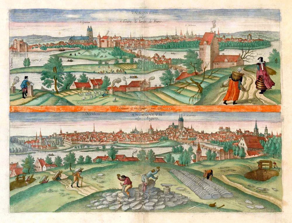
Turones vulgo Tours, le Iardin de France. [on sheet with:] Andegavum vulgo Angiers. c. 1610
Tours and Angers, by Georg Braun and Frans Hogenberg.
[Item number: 25956]

La Ville de Chalon sur Saone.[Au-dessus de la carte :] Le vray portraict de la ville de Chalon. 1575
Chalon-sur-Saône, by François de Belleforest.
[Item number: 27231]

La Ville de Mascon sur Saone. [Au-dessus de la carte :] Pourtraict de la ville de Mascon. 1575
Mâcon-sur-Saône, by François de Belleforest.
[Item number: 27232]