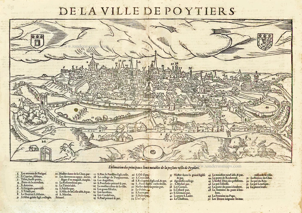
Antique map of Montpellier - Tours - Poitiers by Braun & Hogenberg 1596-1640


Pictavia Vulgo Poictiers [on sheet with:] La pierre levee demie lieue de Poictiers [and] Prospectus Montis Henrici vulgo Montherri.
Item Number: 22071 Authenticity Guarantee
Category: Antique maps > Europe > France
Three views on one sheet, painted by Georg Hoefnagel in 1561.
POITIERS - The Raised Stone of Poitiers:
Translation of the captions: Pictavia, in the vernacular Poitiers. - The Pierre levée, a half mile from Poitiers.
Commentary by Braun: "A gently burbling little stream makes the view of the city even more attractive. [...] About half a mile from Poitiers on the road to Berry, one can admire an extremely large rock resting on five smaller rocks, about 14 feet wide. Walkers generally carve their names into it as a memento. How and in what manner this rock was put there has been the subject of much discussion, but nothing certain can be written about it."
In the top illustration, the city of Poitiers is presented in a view from the east. Prominent in the foreground is the Pont Neuf leading over the Clain. The steeples on the skyline include those of the Romanesque church of Saint-Hilaire-le-Grand on the far left, the Gothic cathedral of Saint-Pierre and the Romanesque church of Sainte-Radegonde on the far right, and somewhat to their left, less prominently, the late Romanesque church of Notre-Dame-la Grande. The illustration below left shows a dolmen known as the "Raised stone of Poitiers", a massive, flat rock resting on five smaller stones. This Megalithic tomb lies about half a mile from Poitiers on the road to Bourges. As mentioned in the text, the stone has been carved with the names of passers-by, here including the draughtsman Georg Hoefnagel in 1561, the cartographer Abraham Ortelius and the author Georg Braun, who is supposed to have visited the spot in 1580.
MONTARGIS:
Caption: View of Montis Henrici, in the vernacular Montargis.
The illustration shows the town of Montargis, which lies east of Orléans on the Loing. Its main sights are the hilltop château, dating back to the 11th century, today only a ruin, and the parish church of Sainte-Madeleine. The draughtsman Georg Hoefnagel is visible on the left above the sunken road. (Taschen)
Copper engraving
Size: 37 x 49.5cm (14.4 x 19.3 inches)
Verso text: Latin
Condition: Excellent, nice old colour.
Condition Rating: A+
From: Civitates Orbis Terrarum, ... Part 5. Köln, 1598.