
Antique map of Strasbourg by Braun & Hogenberg 1572-1624
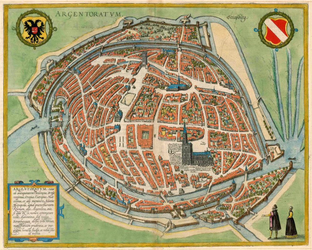

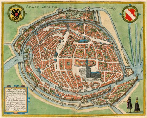


Cartouche: Strasbourg, mentioned since antiquity by Ptolemy, St Jerome, Orosius, Eutropius, Marcellinus and others, is the capital of the Alsace, on the nearby flowing Rhine, called by others Argentina or Aurentina but Strasbourg by the ordinary people. A city widely famed for the virtue, prudence and integrity of the magistracy, respected scientific studies and a well-known school.
Strasbourg is seen from a bird's-eye perspective in a plan view in which the blocks of houses are markedly contracted in favour of the broad streets and squares. The northern tower, 142 m high and built from 1227 to 1439, made the cathedral the tallest Christian church until the 19th century. In 1262, the city was declared a Free Imperial City, of which seven were in total, and profited from many privileges and a certain independence. From the 14th century onwards, it formed a major economic and cultural centre, with close links to cities in Upper Italy.
Copper engraving by Abraham Hogenberg after a map by Conrad Morant, 1548. The view of the city and the Latin texts were taken over verbatim. Morant has been shown to have collaborated c. 1550 on Munster's Cosmographia, so there are also similarities with the woodcut there.
Braun G. & Hogenberg F. and the Civitates Orbis Terrarum.
The Civitates Orbis Terrarum, also known as the 'Braun & Hogenberg', is a six-volume town atlas and the most excellent book of town views and plans ever published: 363 engravings, sometimes beautifully coloured. It was one of the best-selling works in the last quarter of the 16th century. Georg Braun, a skilled writer, wrote the text accompanying the plans and views on the verso. Many plates were engraved after the original drawings of a professional artist, Joris Hoefnagel (1542-1600). The first volume was published in Latin in 1572 and the sixth in 1617. Frans Hogenberg, a talented engraver, created the tables for volumes I through IV, and Simon van den Neuwel made those for volumes V and VI. Other contributors were cartographers Daniel Freese and Heinrich Rantzau, who provided valuable geographical information. Works by Jacob van Deventer, Sebastian Münster, and Johannes Stumpf were also used as references. Translations appeared in German and French, making the atlas accessible to a broader audience.
Since its original publication of volume 1 in 1572, the Civitates Orbis Terrarum has left an indelible mark on the history of cartography. Seven more editions followed the first volume in 1575, 1577, 1582, 1588, 1593, 1599, and 1612. Vol.2, initially released in 1575, saw subsequent editions in 1597 and 1612. The subsequent volumes, each a treasure trove of historical insights, graced the world in 1581, 1588, 1593, 1599, and 1606. The German translation of the first volume, a testament to its widespread appeal, debuted in 1574, followed by the French edition in 1575.
Several printers were involved: Theodor Graminaeus, Heinrich von Aich, Gottfried von Kempen, Johannis Sinniger, Bertram Buchholtz, and Peter von Brachel, all of whom worked in Cologne.
Georg Braun (1541-1622)
Georg Braun, the author of the text accompanying the plans and views in the Civitates Orbis Terrarum, was born in Cologne in 1541. After his studies in Cologne, he entered the Jesuit Order as a novice, indicating his commitment to learning and intellectual pursuits. In 1561, he obtained his bachelor's degree; in 1562, he received his Magister Artium, further demonstrating his academic achievements. Although he left the Jesuit Order, he continued his studies in theology, gaining a licentiate in theology. His theological background likely influenced the content and tone of the text in the Civitates Orbis Terrarum, adding a unique perspective to the work.
Frans Hogenberg (1535-1590)
Frans Hogenberg was a Flemish and German painter, engraver, and mapmaker. He was born in Mechelen as the son of Nicolaas Hogenberg.
By the end of the 1560s, Frans Hogenberg was employed upon Abraham Ortelius's Theatrum Orbis Terrarum, published in 1570; he is named an engraver of numerous maps. In 1568, he was banned from Antwerp by the Duke of Alva and travelled to London, where he stayed a few years before emigrating to Cologne. He immediately embarked on his two most important works, the Civitates, published in 1572 and the Geschichtsblätter, which appeared in several series from 1569 until about 1587.
Thanks to large-scale projects like the Geschichtsblätter and the Civitates, Hogenberg's social circumstances improved with each passing year. He died as a wealthy man in Cologne in 1590.
Argentoratum, cuius ob antiquitatem Ptolemeus, ...
Item Number: 6083 Authenticity Guarantee
Category: Antique maps > Europe > France
Antique map of Strasbourg by Braun & Hogenberg.
Title: Argentoratum, cuius ob antiquitatem Ptolemeus, ...
Date: 1572-1624.
Copper engraving, printed on paper.
Size (not including margins): 340 x 420mm (13.39 x 16.54 inches).
Verso: Latin text.
Condition: Superb old colour, excellent.
Condition Rating: A+.
From: Civitates Orbis Terrarum, ... Part 1. Köln, 1572-1624. (Van der Krogt 4, 41:1.1)
Cartouche: Strasbourg, mentioned since antiquity by Ptolemy, St Jerome, Orosius, Eutropius, Marcellinus and others, is the capital of the Alsace, on the nearby flowing Rhine, called by others Argentina or Aurentina but Strasbourg by the ordinary people. A city widely famed for the virtue, prudence and integrity of the magistracy, respected scientific studies and a well-known school.
Strasbourg is seen from a bird's-eye perspective in a plan view in which the blocks of houses are markedly contracted in favour of the broad streets and squares. The northern tower, 142 m high and built from 1227 to 1439, made the cathedral the tallest Christian church until the 19th century. In 1262, the city was declared a Free Imperial City, of which seven were in total, and profited from many privileges and a certain independence. From the 14th century onwards, it formed a major economic and cultural centre, with close links to cities in Upper Italy.
Copper engraving by Abraham Hogenberg after a map by Conrad Morant, 1548. The view of the city and the Latin texts were taken over verbatim. Morant has been shown to have collaborated c. 1550 on Munster's Cosmographia, so there are also similarities with the woodcut there.
Braun G. & Hogenberg F. and the Civitates Orbis Terrarum.
The Civitates Orbis Terrarum, also known as the 'Braun & Hogenberg', is a six-volume town atlas and the most excellent book of town views and plans ever published: 363 engravings, sometimes beautifully coloured. It was one of the best-selling works in the last quarter of the 16th century. Georg Braun, a skilled writer, wrote the text accompanying the plans and views on the verso. Many plates were engraved after the original drawings of a professional artist, Joris Hoefnagel (1542-1600). The first volume was published in Latin in 1572 and the sixth in 1617. Frans Hogenberg, a talented engraver, created the tables for volumes I through IV, and Simon van den Neuwel made those for volumes V and VI. Other contributors were cartographers Daniel Freese and Heinrich Rantzau, who provided valuable geographical information. Works by Jacob van Deventer, Sebastian Münster, and Johannes Stumpf were also used as references. Translations appeared in German and French, making the atlas accessible to a broader audience.
Since its original publication of volume 1 in 1572, the Civitates Orbis Terrarum has left an indelible mark on the history of cartography. Seven more editions followed the first volume in 1575, 1577, 1582, 1588, 1593, 1599, and 1612. Vol.2, initially released in 1575, saw subsequent editions in 1597 and 1612. The subsequent volumes, each a treasure trove of historical insights, graced the world in 1581, 1588, 1593, 1599, and 1606. The German translation of the first volume, a testament to its widespread appeal, debuted in 1574, followed by the French edition in 1575.
Several printers were involved: Theodor Graminaeus, Heinrich von Aich, Gottfried von Kempen, Johannis Sinniger, Bertram Buchholtz, and Peter von Brachel, all of whom worked in Cologne.
Georg Braun (1541-1622)
Georg Braun, the author of the text accompanying the plans and views in the Civitates Orbis Terrarum, was born in Cologne in 1541. After his studies in Cologne, he entered the Jesuit Order as a novice, indicating his commitment to learning and intellectual pursuits. In 1561, he obtained his bachelor's degree; in 1562, he received his Magister Artium, further demonstrating his academic achievements. Although he left the Jesuit Order, he continued his studies in theology, gaining a licentiate in theology. His theological background likely influenced the content and tone of the text in the Civitates Orbis Terrarum, adding a unique perspective to the work.
Frans Hogenberg (1535-1590)
Frans Hogenberg was a Flemish and German painter, engraver, and mapmaker. He was born in Mechelen as the son of Nicolaas Hogenberg.
By the end of the 1560s, Frans Hogenberg was employed upon Abraham Ortelius's Theatrum Orbis Terrarum, published in 1570; he is named an engraver of numerous maps. In 1568, he was banned from Antwerp by the Duke of Alva and travelled to London, where he stayed a few years before emigrating to Cologne. He immediately embarked on his two most important works, the Civitates, published in 1572 and the Geschichtsblätter, which appeared in several series from 1569 until about 1587.
Thanks to large-scale projects like the Geschichtsblätter and the Civitates, Hogenberg's social circumstances improved with each passing year. He died as a wealthy man in Cologne in 1590.