
Canal du Midi, by Coronelli V.M. 1691
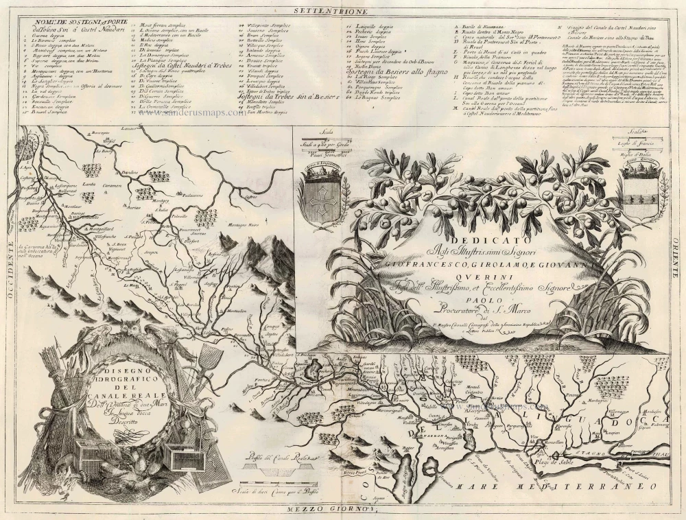
A magnificent and highly decorative map of the Canal du Midi in southern France, engraved by Vincenzo Maria Coronelli and published in Venice in 1691.
The map illustrates the course of the Canal du Midi, originally known as the Canal Royal des Deux Mers, one of the greatest engineering achievements of seventeenth-century Europe. Constructed between 1666 and 1681 under the direction of Pierre-Paul Riquet, the canal connected the Garonne River system, leading to the Atlantic Ocean, with the Mediterranean Sea, establishing an important inland navigation route across southern France.
Coronelli's elaborate engraving depicts the canal and its surrounding waterways, extending from the region of Toulouse in the west to the Mediterranean coast near the Étang de Thau in the east. Numerous towns, villages, rivers, mountains and tributaries are carefully indicated, together with the locks, reservoirs and other hydraulic installations associated with the canal.
The upper section includes an extensive numbered key identifying the locks and other features along the waterway, along with explanatory notes. The map is particularly remarkable for its elaborate Baroque decoration. In the lower left corner, a magnificent title cartouche is surrounded by surveying instruments, fishing nets, aquatic birds, and other allegorical elements referring to navigation and hydraulic engineering. A second, equally impressive cartouche occupies the centre-right of the engraving, with an elaborate dedication to the Querini family of Venice, framed by luxuriant foliage and surmounted by two coats of arms.
The map provides a fascinating record of one of the most ambitious public works projects of the reign of Louis XIV. Combining detailed geographical information with exceptionally fine decorative engraving, it is an outstanding example of Coronelli's cartographic artistry.
Vincenzo Maria Coronelli (1650–1718) was a Venetian Franciscan friar, cosmographer, cartographer and globe maker. Appointed Cosmographer to the Republic of Venice, he became one of the most celebrated cartographers of his time. His monumental Atlante Veneto, published from 1691 onwards, ranks among the most impressive achievements of late seventeenth-century Italian cartography.
Vincenzo Coronelli (1650-1718)
Vincenzo Coronelli was born in Venice on 16 August 1650 and primarily brought up in Ravenna. He returned to Venice in 1665 and joined the convent of the Minor Conventuals. Five years later, he was sent to Rome to study, and by 1673, he was already a doctor of theology.
Having achieved fame by constructing two globes for the Duke of Parma, he was invited to Paris for three years in 1681 and made two enormous examples for Louis XIV. On his return to Venice, he assiduously collected cartographic material and founded the Academy of the Argonauts. In 1685, he was appointed Cosmographer to the Republic of Venice and authorised to publish a large atlas. He became a geography lecturer at the University of Venice and brought out an Atlante Veneto the following year.
In 1696, he visited Germany, Holland and southern England. During intervals in compiling his vast encyclopaedia, he continued with cartographic projects up to 1709. He died in his native Venice on 9 December 1718.
Coronelli became famous for his globes. In addition, he was a renowned encyclopaedist, mapmaker and geographer. Most of his maps and other material are gathered in his Atlante Veneto (13 vols, 1690-1705). The first volume, subtitled Descrizione generale istorica geografica, was his masterpiece, planned as an extension of Blaeu’s atlas.
Other volumes of the atlas which contain maps are Isolario, two parts (1696-8), with detailed maps and plans, mostly of islands; Corso geografico, two parts based on the edition 1694-7; Libro de’ globi (1697); and Lo Specchio del Mare, a reprint of Levanto's Lo Specchio del Mare Mediterraneo of 1664.
The other vital aspects of his mapping are those arising from the Venetian conquest and his travels. His most extensive military compilation was the Teatro della Guerra, in more than 30 volumes.
Disegno Idrografico del Canale Reale ...
Item Number: 23172 Authenticity Guarantee
Category: Antique maps > Europe > France
Map of the Canal du Midi.
The map shows the canal linking the Atlantic and Mediterranean and has a keyed text in the upper part.
Title: Disegno Idrografico del Canale Reale ...
Date: 1691.
Copper engraving, printed on paper.
Size (not including margins): 450 x 610mm (17.72 x 24.02 inches).
Verso: Blank.
Condition: Slight discolouration at centrefold, else good.
Condition Rating: A.
From: Atlante Veneto, nel quale si contiene la descrittione... degl' Imperii, Regni, Provincie, e Stati dell' Universo. Venice: Girolamo Albrizzi, 1691. Shirley (Brit.Lib.), T.CORO-7a
A magnificent and highly decorative map of the Canal du Midi in southern France, engraved by Vincenzo Maria Coronelli and published in Venice in 1691.
The map illustrates the course of the Canal du Midi, originally known as the Canal Royal des Deux Mers, one of the greatest engineering achievements of seventeenth-century Europe. Constructed between 1666 and 1681 under the direction of Pierre-Paul Riquet, the canal connected the Garonne River system, leading to the Atlantic Ocean, with the Mediterranean Sea, establishing an important inland navigation route across southern France.
Coronelli's elaborate engraving depicts the canal and its surrounding waterways, extending from the region of Toulouse in the west to the Mediterranean coast near the Étang de Thau in the east. Numerous towns, villages, rivers, mountains and tributaries are carefully indicated, together with the locks, reservoirs and other hydraulic installations associated with the canal.
The upper section includes an extensive numbered key identifying the locks and other features along the waterway, along with explanatory notes. The map is particularly remarkable for its elaborate Baroque decoration. In the lower left corner, a magnificent title cartouche is surrounded by surveying instruments, fishing nets, aquatic birds, and other allegorical elements referring to navigation and hydraulic engineering. A second, equally impressive cartouche occupies the centre-right of the engraving, with an elaborate dedication to the Querini family of Venice, framed by luxuriant foliage and surmounted by two coats of arms.
The map provides a fascinating record of one of the most ambitious public works projects of the reign of Louis XIV. Combining detailed geographical information with exceptionally fine decorative engraving, it is an outstanding example of Coronelli's cartographic artistry.
Vincenzo Maria Coronelli (1650–1718) was a Venetian Franciscan friar, cosmographer, cartographer and globe maker. Appointed Cosmographer to the Republic of Venice, he became one of the most celebrated cartographers of his time. His monumental Atlante Veneto, published from 1691 onwards, ranks among the most impressive achievements of late seventeenth-century Italian cartography.
Vincenzo Coronelli (1650-1718)
Vincenzo Coronelli was born in Venice on 16 August 1650 and primarily brought up in Ravenna. He returned to Venice in 1665 and joined the convent of the Minor Conventuals. Five years later, he was sent to Rome to study, and by 1673, he was already a doctor of theology.
Having achieved fame by constructing two globes for the Duke of Parma, he was invited to Paris for three years in 1681 and made two enormous examples for Louis XIV. On his return to Venice, he assiduously collected cartographic material and founded the Academy of the Argonauts. In 1685, he was appointed Cosmographer to the Republic of Venice and authorised to publish a large atlas. He became a geography lecturer at the University of Venice and brought out an Atlante Veneto the following year.
In 1696, he visited Germany, Holland and southern England. During intervals in compiling his vast encyclopaedia, he continued with cartographic projects up to 1709. He died in his native Venice on 9 December 1718.
Coronelli became famous for his globes. In addition, he was a renowned encyclopaedist, mapmaker and geographer. Most of his maps and other material are gathered in his Atlante Veneto (13 vols, 1690-1705). The first volume, subtitled Descrizione generale istorica geografica, was his masterpiece, planned as an extension of Blaeu’s atlas.
Other volumes of the atlas which contain maps are Isolario, two parts (1696-8), with detailed maps and plans, mostly of islands; Corso geografico, two parts based on the edition 1694-7; Libro de’ globi (1697); and Lo Specchio del Mare, a reprint of Levanto's Lo Specchio del Mare Mediterraneo of 1664.
The other vital aspects of his mapping are those arising from the Venetian conquest and his travels. His most extensive military compilation was the Teatro della Guerra, in more than 30 volumes.
Related items

Praefectura Lugdunensis Generalis ... c. 1700
Lyon, by Valk G.& L.
[Item number: 1273]

Lorraine, Vers Le Midi 1636
Lorraine by Hondius - Janssonius
[Item number: 8502]

Lionnois, Forest, Beauviolois et Masconnois 1644-45
Lyonnais, by Willem & Joan Blaeu.
[Item number: 14849]

Les Bas Cevennes, Dans le Languedoc, ou le Diocese de Montpellier Divisé en Neuf Archiprêtrez 1721-41
The Cévennes with the bishopric of Montpellier, by C. Allard - Covens & Mortier.
[Item number: 23791]

Le Gouvernement General du Lyonnois Comprenant les Provinces du Lyonnois, du Forez et du Beaujolois &c. 1721-41
Rhone-Alpes, by Covens & Mortier.
[Item number: 23795]