
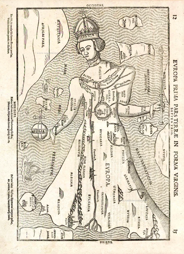
Old antique map of Europa Virgo - Europe in the shape of a queen, by H. Bünting. 1587
Heinrich Bünting (Hannover, 1545-1606)
Heinrich Bünting was a protestant pastor and theologian. He was also a brewer in Hannover, and he was concerned with history and wrote a Braunschweigische Chronica in 1584. His main work was the popular Itinerarium Sacrae Scripturae, which after the first edition in Magdeburg in 1581 had many editions in German, Latin, Dutch, Swedish, Danish, Czech and English.
The book gave an overview of biblical geography based on the travel descriptions of various notable people from the Old and New Testaments. It contained ten woodcut maps, including three figurative maps: the world depicted as a cloverleaf with Jerusalem in the centre, Europe in the shape of a crowned woman, and Asia as the winged horse Pegasus.
Europa Prima Pars Terrae in Forma Virginis.
Item Number: 25787 Authenticity Guarantee
Category: Antique maps > Europe > Europe Continent
Old, antique map of Europa Virgo - Europe in the shape of a queen, by H. Bünting.
Date of the first edition: 1587
Date of this map: 1587
Woodcut, printed on paper.
Size (not including margins): 35.5 x 23.5cm (13.8 x 9.2 inches)
Verso text: German
Condition: Excellent.
Condition Rating: A+
References: Van der Heijden (Europe), 42.
From: Itinerarium Sacrae Scripturae. Wittenburg, 1587.
This is one of ten maps in Bünting's Itinerarium, in which the author, a theological commentator, rewrote the Bible as an illustrated travel book. Other maps in the series bear out his imaginative approach to cartography, which pictures the World in the form of a cloverleaf and Asia as Pegasus.
Heinrich Bünting (Hannover, 1545-1606)
Heinrich Bünting was a protestant pastor and theologian. He was also a brewer in Hannover, and he was concerned with history and wrote a Braunschweigische Chronica in 1584. His main work was the popular Itinerarium Sacrae Scripturae, which after the first edition in Magdeburg in 1581 had many editions in German, Latin, Dutch, Swedish, Danish, Czech and English.
The book gave an overview of biblical geography based on the travel descriptions of various notable people from the Old and New Testaments. It contained ten woodcut maps, including three figurative maps: the world depicted as a cloverleaf with Jerusalem in the centre, Europe in the shape of a crowned woman, and Asia as the winged horse Pegasus.
Related items

Imperii Caroli Magni et Vicinarum Regionum Descriptio ... 1635
Empire of Charlemagne, by Blaeu W.& J.
[Item number: 9393]
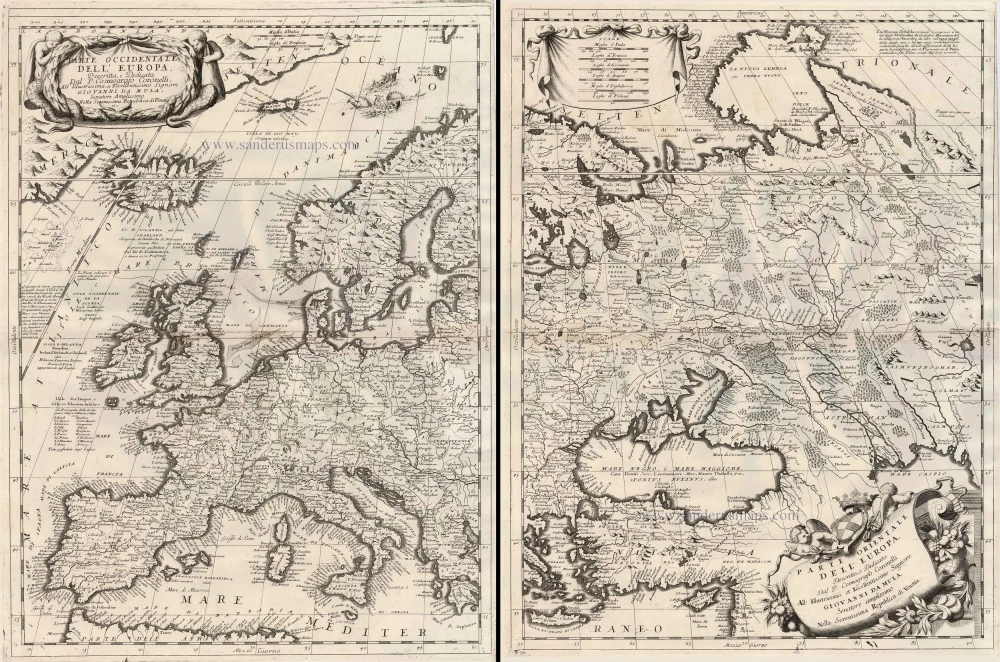
Parte Occidentale dell'Europa ... [in set with] Parte Orientale dell'Europa ... 1691
Europe, by V.M. Coronelli.
[Item number: 23186]

Europa Pars Tenet haec Mundi Reliquas Celeberrima Partes c. 1730.
Europe by G.& L. Valk.
[Item number: 24536]