
Europe by Zürner A.F. c. 1700

Adam Friedrich Zürner (1679-1742)
A.F. Zürner made his first maps during his studies in Leipzig. In 1713, Elector August dem Starken gave him the order to bring all offices of the Electorate of Saxony in the same way as the two maps of the offices of Großenhain and Dresden. Zürner was supposed to complete the electorate survey, which was begun in 1586 by Matthias Oeder under Elector Christian I.
In 1716 he was awarded the title of "Electoral Saxon and Royal Polish Geographer". In the same year, he was appointed a member of the Prussian Academy of Sciences. Finally, in the late autumn of 1718, he presented his "New Chursächsische Post-Charte".
The geographer Johann Gottfried Gregorii alias Melissantes and the copper engraver Johann Christoph Weigel from Nuremberg used the good map material and Zürner's signature system as early as 1723 to create the continuous Atlas Portatilis Germanicus.
In addition to his surveying work, Zürner wrote several travel guides in the last years of his life. He worked, among others, with the Homann Heirs firm and the Schenk family. He died on December 18, 1742, in Dresden.
Today he is considered a well-known German cartographer. His best-known works were the Neue Chursächsische Post-Charte (16 sheets) and the Atlas Augusteus der Chursächsische Lande (Atlas Augusteus Saxonicus: 40 general and 40 special maps).
Europae in Tabula Geographica Delineatio.
Item Number: 25659 Authenticity Guarantee
Category: Antique maps > Europe > Europe Continent
Old, antique map of Europe by Zürner A.F.
With an inset of Northern Scandinavia.
Copper engraving
Size (not including margins): 50 x 58cm (19.5 x 22.6 inches)
Verso: Blank
Condition: Original coloured, excellent.
Condition Rating: A+
From: Schenk, Atlas Contractus sive Mapparum Geographicarum Sansoniarum auctarum et Correctarum. Amsterdam, c. 1700. (Koeman, Sche 2)
Adam Friedrich Zürner (1679-1742)
A.F. Zürner made his first maps during his studies in Leipzig. In 1713, Elector August dem Starken gave him the order to bring all offices of the Electorate of Saxony in the same way as the two maps of the offices of Großenhain and Dresden. Zürner was supposed to complete the electorate survey, which was begun in 1586 by Matthias Oeder under Elector Christian I.
In 1716 he was awarded the title of "Electoral Saxon and Royal Polish Geographer". In the same year, he was appointed a member of the Prussian Academy of Sciences. Finally, in the late autumn of 1718, he presented his "New Chursächsische Post-Charte".
The geographer Johann Gottfried Gregorii alias Melissantes and the copper engraver Johann Christoph Weigel from Nuremberg used the good map material and Zürner's signature system as early as 1723 to create the continuous Atlas Portatilis Germanicus.
In addition to his surveying work, Zürner wrote several travel guides in the last years of his life. He worked, among others, with the Homann Heirs firm and the Schenk family. He died on December 18, 1742, in Dresden.
Today he is considered a well-known German cartographer. His best-known works were the Neue Chursächsische Post-Charte (16 sheets) and the Atlas Augusteus der Chursächsische Lande (Atlas Augusteus Saxonicus: 40 general and 40 special maps).
Related items

Imperii Caroli Magni et Vicinarum Regionum Descriptio ... 1635
Empire of Charlemagne, by Blaeu W.& J.
[Item number: 9393]
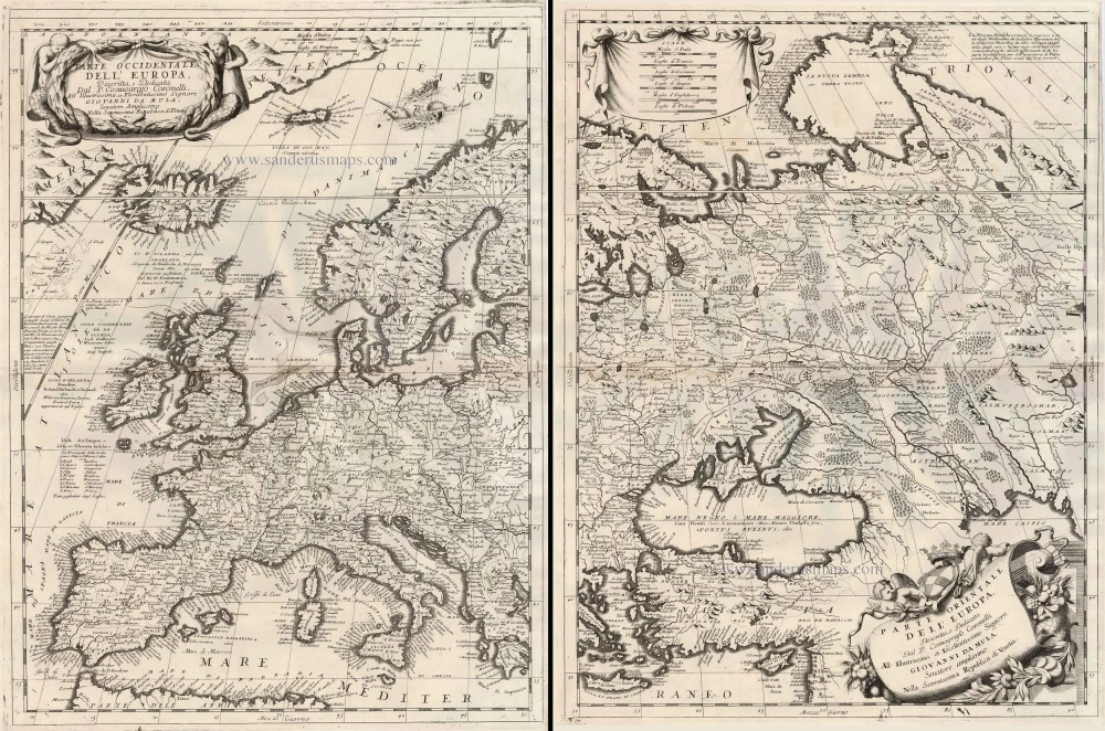
Parte Occidentale dell'Europa ... [in set with] Parte Orientale dell'Europa ... 1691
Europe, by V.M. Coronelli.
[Item number: 23186]

Europa Pars Tenet haec Mundi Reliquas Celeberrima Partes c. 1730.
Europe by G.& L. Valk.
[Item number: 24536]