
Old antique map of Europe by J. Janssonius 1630
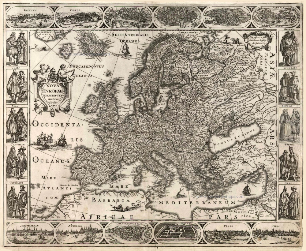

This map belongs to a set of the four continents by Jodocus Hondius, probably engraved by Pieter van den Keere. The title appears in the Atlantic Ocean in a cartouche flanked by two putti and crowned by a clock with Roman numerals, in the centre of which is a skull surrounded by flames. The imprint appears in a cartouche in the upper right corner.
The map's side borders contain costumed European figures, and along the upper and lower edges run decorative borders with pictures of six European towns in oval frames. Top border: Lisbona; Toledo; London; Paris; Roma; and Venetia. Bottom border: Amsterdam, Nurnberg, Constantinople; Moscow, Prague and Vilna.
The Janssonius Family
Joannes Janssonius (Arnhem, 1588-1664), son of the Arnhem publisher Jan Janssen, married Elisabeth Hondius, daughter of Jodocus Hondius, in Amsterdam in 1612. After his marriage, he settled down in this town as a bookseller and publisher of cartographic material. In 1618, he established himself in Amsterdam next door to Blaeu’s bookshop. He entered into serious competition with Willem Jansz. Blaeu when copying Blaeu’s Licht der Zeevaert after the expiration of the privilege in 1620. His activities concerned the publication of atlases, books, single maps, and an extensive book trade with branches in Frankfurt, Danzig, Stockholm, Copenhagen, Berlin, Koningsbergen, Geneva, and Lyon. In 1631, he began publishing atlases together with Henricus Hondius.
In the early 1640s, Henricus Hondius left the atlas publishing business to Janssonius. Competition with Joan Blaeu, Willem’s son and successor, in atlas production, prompted Janssonius to enlarge his Atlas Novus finally into a work of six volumes, into which a sea atlas and an atlas of the Old World were inserted. Other atlases published by Janssonius are Mercator’s Atlas Minor, Hornius’s historical atlas (1652), the townbooks in eight volumes (1657), Cellarius’s Atlas Coelestis and several sea atlases and pilot guides.
After the death of Joannes Janssonius, the shop and publishing firm were continued by the heirs under the direction of Johannes van Waesbergen (c. 1616-1681), son-in-law of Joannes Janssonius. Van Waesbergen added Janssonius's name to his own.
In 1676, Joannes Janssonius’s heirs sold by auction “all the remaining Atlases in Latin, French, High and Low German, as well as the Stedeboecken in Latin, in 8 volumes, bound and unbound, maps, plates belonging to the Atlas and Stedeboecken.” The copperplates from Janssonius’s atlases were afterwards sold to Schenk and Valck.
Nova Europae Descriptio Autore I. Hondio.
Item Number: 25192 Authenticity Guarantee
Category: Antique maps > Europe > Europe Continent
Old, antique map of Europe by J. Hondius Jr.
Cartographer: J. Hondius Jr
Date of the first edition: 1623
Date of this map: 1630
Copper engraving
Size: 46.5 x 56.5cm (18.1 x 22 inches)
Verso: Blank
Condition: Third vignette in the right border cut out and replaced in facsimile.
Condition Rating: C
References: Van der Krogt 1, 1000:1C.1; Schilder 6, 28.2 Second state with the imprint of J. Janssonius..
From: Atlantis Maioris Appendix, sive Pars Altera, ... Amsterdam, J. Janssonius, 1630. (Van der Krogt 1, 1:202)
This map belongs to a set of the four continents by Jodocus Hondius, probably engraved by Pieter van den Keere. The title appears in the Atlantic Ocean in a cartouche flanked by two putti and crowned by a clock with Roman numerals, in the centre of which is a skull surrounded by flames. The imprint appears in a cartouche in the upper right corner.
The map's side borders contain costumed European figures, and along the upper and lower edges run decorative borders with pictures of six European towns in oval frames. Top border: Lisbona; Toledo; London; Paris; Roma; and Venetia. Bottom border: Amsterdam, Nurnberg, Constantinople; Moscow, Prague and Vilna.
The Janssonius Family
Joannes Janssonius (Arnhem, 1588-1664), son of the Arnhem publisher Jan Janssen, married Elisabeth Hondius, daughter of Jodocus Hondius, in Amsterdam in 1612. After his marriage, he settled down in this town as a bookseller and publisher of cartographic material. In 1618, he established himself in Amsterdam next door to Blaeu’s bookshop. He entered into serious competition with Willem Jansz. Blaeu when copying Blaeu’s Licht der Zeevaert after the expiration of the privilege in 1620. His activities concerned the publication of atlases, books, single maps, and an extensive book trade with branches in Frankfurt, Danzig, Stockholm, Copenhagen, Berlin, Koningsbergen, Geneva, and Lyon. In 1631, he began publishing atlases together with Henricus Hondius.
In the early 1640s, Henricus Hondius left the atlas publishing business to Janssonius. Competition with Joan Blaeu, Willem’s son and successor, in atlas production, prompted Janssonius to enlarge his Atlas Novus finally into a work of six volumes, into which a sea atlas and an atlas of the Old World were inserted. Other atlases published by Janssonius are Mercator’s Atlas Minor, Hornius’s historical atlas (1652), the townbooks in eight volumes (1657), Cellarius’s Atlas Coelestis and several sea atlases and pilot guides.
After the death of Joannes Janssonius, the shop and publishing firm were continued by the heirs under the direction of Johannes van Waesbergen (c. 1616-1681), son-in-law of Joannes Janssonius. Van Waesbergen added Janssonius's name to his own.
In 1676, Joannes Janssonius’s heirs sold by auction “all the remaining Atlases in Latin, French, High and Low German, as well as the Stedeboecken in Latin, in 8 volumes, bound and unbound, maps, plates belonging to the Atlas and Stedeboecken.” The copperplates from Janssonius’s atlases were afterwards sold to Schenk and Valck.