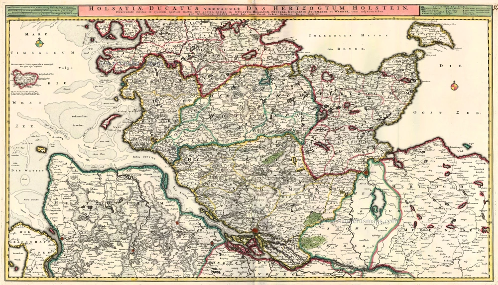
Holstein - Bad Segeberg by Braun G. & Hogenberg F. c. 1593
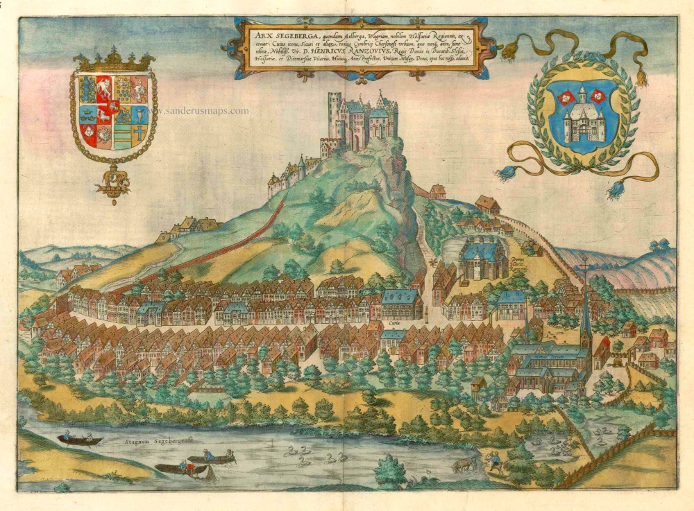


TRANSLATION OF CARTOUCHE TEXT: The castle of Segeberg, formerly Aelberga, embellishes Wagrien, the famous region in Holstein. This work has been adorned with this view as well as views of other cities on the whole Cimbrian Peninsula that have never been published before, by the most illustrious D. Heinrich Rantzau, viceroy of the Danish Kings in the Duchies of Schleswig and Holstein and Dithmarschen and lord of this castle, unique patron of the muses.
COMMENTARY BY BRAUN (on verso): "No one familiar with its location and its great abundance of wood will be surprised to learn that the Duchy of Holsatz, or Holstein, got its name from wood (German Holz) and forests and that Holsatz means "sowed or set in wood and forests". For the rest, it is a flat country with few hills, and the most distinguished of the two is in no way uninhabited. It is also famous far and wide because of its monuments, with which the celebrated Heinrich Rantzau has adorned it."
The castle of Segeberg, shown from the north on the 110-m-high Kalkberg Hill, was built in the 12th century to defend the border area between Saxons and Slavs, together with the Augustinian monastery on the shore of the lake and the market town along the road. The Romanesque church of St Mary is mentioned for the first time in 1199. The castle on the hill was constantly expanded up to 1340 and passed into the possession of Christian I of Denmark in 1449. After this, Segeberg was the seat of the royal Danish governors for a long time, the most famous of which was Heinrich Rantzau, who built the town hall. The castle was destroyed by Swedish troops in 1644. (Taschen)
Braun G. & Hogenberg F. and the Civitates Orbis Terrarum.
The Civitates Orbis Terrarum, also known as the 'Braun & Hogenberg', is a six-volume town atlas and the most excellent book of town views and plans ever published: 363 engravings, sometimes beautifully coloured. It was one of the best-selling works in the last quarter of the 16th century. Georg Braun, a skilled writer, wrote the text accompanying the plans and views on the verso. Many plates were engraved after the original drawings of a professional artist, Joris Hoefnagel (1542-1600). The first volume was published in Latin in 1572 and the sixth in 1617. Frans Hogenberg, a talented engraver, created the tables for volumes I through IV, and Simon van den Neuwel made those for volumes V and VI. Other contributors were cartographers Daniel Freese and Heinrich Rantzau, who provided valuable geographical information. Works by Jacob van Deventer, Sebastian Münster, and Johannes Stumpf were also used as references. Translations appeared in German and French, making the atlas accessible to a broader audience.
Since its original publication of volume 1 in 1572, the Civitates Orbis Terrarum has left an indelible mark on the history of cartography. Seven more editions followed the first volume in 1575, 1577, 1582, 1588, 1593, 1599, and 1612. Vol.2, initially released in 1575, saw subsequent editions in 1597 and 1612. The subsequent volumes, each a treasure trove of historical insights, graced the world in 1581, 1588, 1593, 1599, and 1606. The German translation of the first volume, a testament to its widespread appeal, debuted in 1574, followed by the French edition in 1575.
Several printers were involved: Theodor Graminaeus, Heinrich von Aich, Gottfried von Kempen, Johannis Sinniger, Bertram Buchholtz, and Peter von Brachel, all of whom worked in Cologne.
Georg Braun (1541-1622)
Georg Braun, the author of the text accompanying the plans and views in the Civitates Orbis Terrarum, was born in Cologne in 1541. After his studies in Cologne, he entered the Jesuit Order as a novice, indicating his commitment to learning and intellectual pursuits. In 1561, he obtained his bachelor's degree; in 1562, he received his Magister Artium, further demonstrating his academic achievements. Although he left the Jesuit Order, he continued his studies in theology, gaining a licentiate in theology. His theological background likely influenced the content and tone of the text in the Civitates Orbis Terrarum, adding a unique perspective to the work.
Frans Hogenberg (1535-1590)
Frans Hogenberg was a Flemish and German painter, engraver, and mapmaker. He was born in Mechelen as the son of Nicolaas Hogenberg.
By the end of the 1560s, Frans Hogenberg was employed upon Abraham Ortelius's Theatrum Orbis Terrarum, published in 1570; he is named an engraver of numerous maps. In 1568, he was banned from Antwerp by the Duke of Alva and travelled to London, where he stayed a few years before emigrating to Cologne. He immediately embarked on his two most important works, the Civitates, published in 1572 and the Geschichtsblätter, which appeared in several series from 1569 until about 1587.
Thanks to large-scale projects like the Geschichtsblätter and the Civitates, Hogenberg's social circumstances improved with each passing year. He died as a wealthy man in Cologne in 1590.
Arx Segeberga, quondam Aelberga, Wagriam, Nobilem Holsatiae Regionem, exornat. . . .
Item Number: 15435 Authenticity Guarantee
Category: Antique maps > Europe > Germany - Cities
Old, antique bird’s-eye view plan of Holstein - Bad Segeberg by Braun G. & Hogenberg F.
Title: Arx Segeberga, quondam Aelberga, Wagriam, Nobilem Holsatiae Regionem, exornat. . . .
Date of the first edition: 1588.
Date of this map: c. 1593.
Copper engraving, printed on paper.
Size (not including margins): 335 x 465mm (13.19 x 18.31 inches).
Verso: French text.
Condition: Old coloured, some ink smudging.
Condition Rating: A.
From: Liber Quartus - Théatre des Principales Villes de tout L'Univers. Cologne, c. 1593. (Van der Krogt 4, 41:3.4)
TRANSLATION OF CARTOUCHE TEXT: The castle of Segeberg, formerly Aelberga, embellishes Wagrien, the famous region in Holstein. This work has been adorned with this view as well as views of other cities on the whole Cimbrian Peninsula that have never been published before, by the most illustrious D. Heinrich Rantzau, viceroy of the Danish Kings in the Duchies of Schleswig and Holstein and Dithmarschen and lord of this castle, unique patron of the muses.
COMMENTARY BY BRAUN (on verso): "No one familiar with its location and its great abundance of wood will be surprised to learn that the Duchy of Holsatz, or Holstein, got its name from wood (German Holz) and forests and that Holsatz means "sowed or set in wood and forests". For the rest, it is a flat country with few hills, and the most distinguished of the two is in no way uninhabited. It is also famous far and wide because of its monuments, with which the celebrated Heinrich Rantzau has adorned it."
The castle of Segeberg, shown from the north on the 110-m-high Kalkberg Hill, was built in the 12th century to defend the border area between Saxons and Slavs, together with the Augustinian monastery on the shore of the lake and the market town along the road. The Romanesque church of St Mary is mentioned for the first time in 1199. The castle on the hill was constantly expanded up to 1340 and passed into the possession of Christian I of Denmark in 1449. After this, Segeberg was the seat of the royal Danish governors for a long time, the most famous of which was Heinrich Rantzau, who built the town hall. The castle was destroyed by Swedish troops in 1644. (Taschen)
Braun G. & Hogenberg F. and the Civitates Orbis Terrarum.
The Civitates Orbis Terrarum, also known as the 'Braun & Hogenberg', is a six-volume town atlas and the most excellent book of town views and plans ever published: 363 engravings, sometimes beautifully coloured. It was one of the best-selling works in the last quarter of the 16th century. Georg Braun, a skilled writer, wrote the text accompanying the plans and views on the verso. Many plates were engraved after the original drawings of a professional artist, Joris Hoefnagel (1542-1600). The first volume was published in Latin in 1572 and the sixth in 1617. Frans Hogenberg, a talented engraver, created the tables for volumes I through IV, and Simon van den Neuwel made those for volumes V and VI. Other contributors were cartographers Daniel Freese and Heinrich Rantzau, who provided valuable geographical information. Works by Jacob van Deventer, Sebastian Münster, and Johannes Stumpf were also used as references. Translations appeared in German and French, making the atlas accessible to a broader audience.
Since its original publication of volume 1 in 1572, the Civitates Orbis Terrarum has left an indelible mark on the history of cartography. Seven more editions followed the first volume in 1575, 1577, 1582, 1588, 1593, 1599, and 1612. Vol.2, initially released in 1575, saw subsequent editions in 1597 and 1612. The subsequent volumes, each a treasure trove of historical insights, graced the world in 1581, 1588, 1593, 1599, and 1606. The German translation of the first volume, a testament to its widespread appeal, debuted in 1574, followed by the French edition in 1575.
Several printers were involved: Theodor Graminaeus, Heinrich von Aich, Gottfried von Kempen, Johannis Sinniger, Bertram Buchholtz, and Peter von Brachel, all of whom worked in Cologne.
Georg Braun (1541-1622)
Georg Braun, the author of the text accompanying the plans and views in the Civitates Orbis Terrarum, was born in Cologne in 1541. After his studies in Cologne, he entered the Jesuit Order as a novice, indicating his commitment to learning and intellectual pursuits. In 1561, he obtained his bachelor's degree; in 1562, he received his Magister Artium, further demonstrating his academic achievements. Although he left the Jesuit Order, he continued his studies in theology, gaining a licentiate in theology. His theological background likely influenced the content and tone of the text in the Civitates Orbis Terrarum, adding a unique perspective to the work.
Frans Hogenberg (1535-1590)
Frans Hogenberg was a Flemish and German painter, engraver, and mapmaker. He was born in Mechelen as the son of Nicolaas Hogenberg.
By the end of the 1560s, Frans Hogenberg was employed upon Abraham Ortelius's Theatrum Orbis Terrarum, published in 1570; he is named an engraver of numerous maps. In 1568, he was banned from Antwerp by the Duke of Alva and travelled to London, where he stayed a few years before emigrating to Cologne. He immediately embarked on his two most important works, the Civitates, published in 1572 and the Geschichtsblätter, which appeared in several series from 1569 until about 1587.
Thanks to large-scale projects like the Geschichtsblätter and the Civitates, Hogenberg's social circumstances improved with each passing year. He died as a wealthy man in Cologne in 1590.