
Bremen, by Georg Braun and Frans Hogenberg. c. 1610
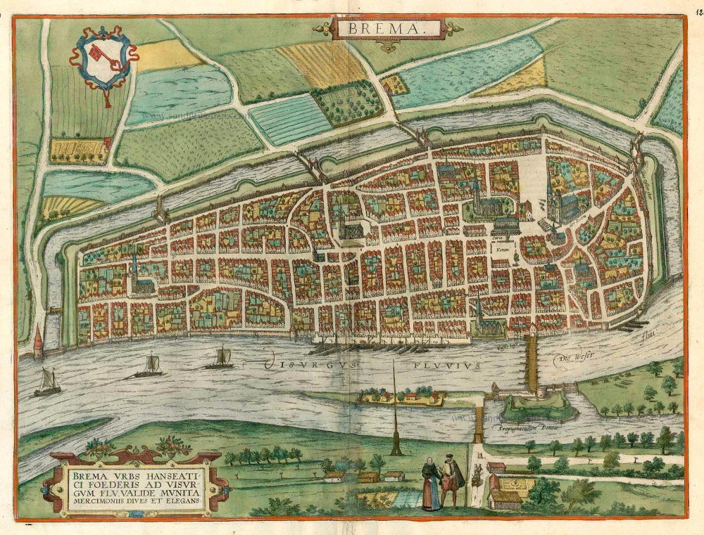


TRANSLATION OF CARTOUCHE TEXT: Bremen, well-fortified and through trade a rich and flourishing Hanseatic city on the Weser.
COMMENTARY BY BRAUN (on verso): "The citizens of the city are either merchants or artisans, and there is an inordinate number of skilled shipwrights. By nature they are quarrelsome, clever and tend towards rebellion, as testified by past and recent history. For this reason the burgomaster of Bremen, Ditmar Kenkel, although a learned man, was obliged to leave the city with other councillors, as he has declared in a book published in Ursel in 1565. [...] There is a large wide market square where all sorts of vital necessities are sold every week. In the middle of the square stands a statue of the Emperor and King, holding only the sword of justice in his hand. One side of the market is dominated by the cathedral, the other by the town hall."
The city is seen from the southwest across the Weser. This is a bird's-eye view of the city with its strictly geometric plan, whereby the perspective is greatly distorted by the staffage figures in the foreground and the extremely steep angle of the far bank of the Weser. Emphasis is placed upon the city's situation on the navigable Weser, which flows out to the North Sea at modern-day Bremerhaven some 60 km to the north. The large marketplace (Forum) in front of the townhall (Curia) can be identified by the statue of Roland, the city's symbol of liberty erected in 1404, and by the cathedral with its two towers of different heights. Although the people of Bremen possessed ocean-going ships in the form of their Hanse cogs from the 12th century onwards, inland navigation also remained important. Thus Bremen became an important point on intersection between domestic and foreign trade, which led in the 16th century to economic prosperity. (Taschen)
Braun G. & Hogenberg F. and the Civitates Orbis Terrarum.
The Civitates Orbis Terrarum, also known as the 'Braun & Hogenberg', is a six-volume town atlas and the most excellent book of town views and plans ever published: 363 engravings, sometimes beautifully coloured. It was one of the best-selling works in the last quarter of the 16th century. Georg Braun, a skilled writer, wrote the text accompanying the plans and views on the verso. Many plates were engraved after the original drawings of a professional artist, Joris Hoefnagel (1542-1600). The first volume was published in Latin in 1572 and the sixth in 1617. Frans Hogenberg, a talented engraver, created the tables for volumes I through IV, and Simon van den Neuwel made those for volumes V and VI. Other contributors were cartographers Daniel Freese and Heinrich Rantzau, who provided valuable geographical information. Works by Jacob van Deventer, Sebastian Münster, and Johannes Stumpf were also used as references. Translations appeared in German and French, making the atlas accessible to a broader audience.
Since its original publication of volume 1 in 1572, the Civitates Orbis Terrarum has left an indelible mark on the history of cartography. Seven more editions followed the first volume in 1575, 1577, 1582, 1588, 1593, 1599, and 1612. Vol.2, initially released in 1575, saw subsequent editions in 1597 and 1612. The subsequent volumes, each a treasure trove of historical insights, graced the world in 1581, 1588, 1593, 1599, and 1606. The German translation of the first volume, a testament to its widespread appeal, debuted in 1574, followed by the French edition in 1575.
Several printers were involved: Theodor Graminaeus, Heinrich von Aich, Gottfried von Kempen, Johannis Sinniger, Bertram Buchholtz, and Peter von Brachel, all of whom worked in Cologne.
Georg Braun (1541-1622)
Georg Braun, the author of the text accompanying the plans and views in the Civitates Orbis Terrarum, was born in Cologne in 1541. After his studies in Cologne, he entered the Jesuit Order as a novice, indicating his commitment to learning and intellectual pursuits. In 1561, he obtained his bachelor's degree; in 1562, he received his Magister Artium, further demonstrating his academic achievements. Although he left the Jesuit Order, he continued his studies in theology, gaining a licentiate in theology. His theological background likely influenced the content and tone of the text in the Civitates Orbis Terrarum, adding a unique perspective to the work.
Frans Hogenberg (1535-1590)
Frans Hogenberg was a Flemish and German painter, engraver, and mapmaker. He was born in Mechelen as the son of Nicolaas Hogenberg.
By the end of the 1560s, Frans Hogenberg was employed upon Abraham Ortelius's Theatrum Orbis Terrarum, published in 1570; he is named an engraver of numerous maps. In 1568, he was banned from Antwerp by the Duke of Alva and travelled to London, where he stayed a few years before emigrating to Cologne. He immediately embarked on his two most important works, the Civitates, published in 1572 and the Geschichtsblätter, which appeared in several series from 1569 until about 1587.
Thanks to large-scale projects like the Geschichtsblätter and the Civitates, Hogenberg's social circumstances improved with each passing year. He died as a wealthy man in Cologne in 1590.
Brema.
Item Number: 16673 Authenticity Guarantee
Category: Antique maps > Europe > Germany - Cities
Old, antique bird’s-eye view plan of Bremen, by Georg Braun and Frans Hogenberg.
Title: Brema.
Date of the first edition: 1596.
Date of this map: c. 1610.
Copper engraving, printed on paper.
Size (not including margins): 368 x 490mm (14.49 x 19.29 inches).
Verso: French text.
Condition: Original coloured, some smudging in lower centre.
Condition Rating: B.
From: Théâtre des Principales Villes de tout l'Univers. Tome 5. c. 1610.
TRANSLATION OF CARTOUCHE TEXT: Bremen, well-fortified and through trade a rich and flourishing Hanseatic city on the Weser.
COMMENTARY BY BRAUN (on verso): "The citizens of the city are either merchants or artisans, and there is an inordinate number of skilled shipwrights. By nature they are quarrelsome, clever and tend towards rebellion, as testified by past and recent history. For this reason the burgomaster of Bremen, Ditmar Kenkel, although a learned man, was obliged to leave the city with other councillors, as he has declared in a book published in Ursel in 1565. [...] There is a large wide market square where all sorts of vital necessities are sold every week. In the middle of the square stands a statue of the Emperor and King, holding only the sword of justice in his hand. One side of the market is dominated by the cathedral, the other by the town hall."
The city is seen from the southwest across the Weser. This is a bird's-eye view of the city with its strictly geometric plan, whereby the perspective is greatly distorted by the staffage figures in the foreground and the extremely steep angle of the far bank of the Weser. Emphasis is placed upon the city's situation on the navigable Weser, which flows out to the North Sea at modern-day Bremerhaven some 60 km to the north. The large marketplace (Forum) in front of the townhall (Curia) can be identified by the statue of Roland, the city's symbol of liberty erected in 1404, and by the cathedral with its two towers of different heights. Although the people of Bremen possessed ocean-going ships in the form of their Hanse cogs from the 12th century onwards, inland navigation also remained important. Thus Bremen became an important point on intersection between domestic and foreign trade, which led in the 16th century to economic prosperity. (Taschen)
Braun G. & Hogenberg F. and the Civitates Orbis Terrarum.
The Civitates Orbis Terrarum, also known as the 'Braun & Hogenberg', is a six-volume town atlas and the most excellent book of town views and plans ever published: 363 engravings, sometimes beautifully coloured. It was one of the best-selling works in the last quarter of the 16th century. Georg Braun, a skilled writer, wrote the text accompanying the plans and views on the verso. Many plates were engraved after the original drawings of a professional artist, Joris Hoefnagel (1542-1600). The first volume was published in Latin in 1572 and the sixth in 1617. Frans Hogenberg, a talented engraver, created the tables for volumes I through IV, and Simon van den Neuwel made those for volumes V and VI. Other contributors were cartographers Daniel Freese and Heinrich Rantzau, who provided valuable geographical information. Works by Jacob van Deventer, Sebastian Münster, and Johannes Stumpf were also used as references. Translations appeared in German and French, making the atlas accessible to a broader audience.
Since its original publication of volume 1 in 1572, the Civitates Orbis Terrarum has left an indelible mark on the history of cartography. Seven more editions followed the first volume in 1575, 1577, 1582, 1588, 1593, 1599, and 1612. Vol.2, initially released in 1575, saw subsequent editions in 1597 and 1612. The subsequent volumes, each a treasure trove of historical insights, graced the world in 1581, 1588, 1593, 1599, and 1606. The German translation of the first volume, a testament to its widespread appeal, debuted in 1574, followed by the French edition in 1575.
Several printers were involved: Theodor Graminaeus, Heinrich von Aich, Gottfried von Kempen, Johannis Sinniger, Bertram Buchholtz, and Peter von Brachel, all of whom worked in Cologne.
Georg Braun (1541-1622)
Georg Braun, the author of the text accompanying the plans and views in the Civitates Orbis Terrarum, was born in Cologne in 1541. After his studies in Cologne, he entered the Jesuit Order as a novice, indicating his commitment to learning and intellectual pursuits. In 1561, he obtained his bachelor's degree; in 1562, he received his Magister Artium, further demonstrating his academic achievements. Although he left the Jesuit Order, he continued his studies in theology, gaining a licentiate in theology. His theological background likely influenced the content and tone of the text in the Civitates Orbis Terrarum, adding a unique perspective to the work.
Frans Hogenberg (1535-1590)
Frans Hogenberg was a Flemish and German painter, engraver, and mapmaker. He was born in Mechelen as the son of Nicolaas Hogenberg.
By the end of the 1560s, Frans Hogenberg was employed upon Abraham Ortelius's Theatrum Orbis Terrarum, published in 1570; he is named an engraver of numerous maps. In 1568, he was banned from Antwerp by the Duke of Alva and travelled to London, where he stayed a few years before emigrating to Cologne. He immediately embarked on his two most important works, the Civitates, published in 1572 and the Geschichtsblätter, which appeared in several series from 1569 until about 1587.
Thanks to large-scale projects like the Geschichtsblätter and the Civitates, Hogenberg's social circumstances improved with each passing year. He died as a wealthy man in Cologne in 1590.
Related items

Eschwege [on sheet with] Fritzlar. 1616
Eschwege and Fritzlar, by Braun & Hogenberg.
[Item number: 18533]

Augusta Iuxta Figuram ... 1612
Augsburg, by Georg Braun and Frans Hogenberg.
[Item number: 22337]

Arnsberg. 1599
Arnsberg by Braun and Hogenberg.
[Item number: 24096]
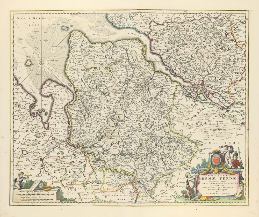
Ducatus Bremae et Ferdae, Maximaeque partis Ducatus Stormariae, Comitatus Oldenburgi, Albis, Visurgisque Fluminum Novissima Descriptio. 1656-77
The Duchies of Bremen and Verden by Nicolaes Visscher I.
[Item number: 28547]

Bremen. 1686
Bremen by Christoph Riegel.
[Item number: 31515]

Ducatus Bremae & Ferdae Maximaeque partis Fluminis Visurgis. 1682-88
The Duchies of Bremen and Verden, including Oldenburg and Hamburg on the River Elbe, by Frederick De Wit.
[Item number: 32635]