
Freiberg (Saxony), by Georg Braun and Frans Hogenberg. 1575-1612
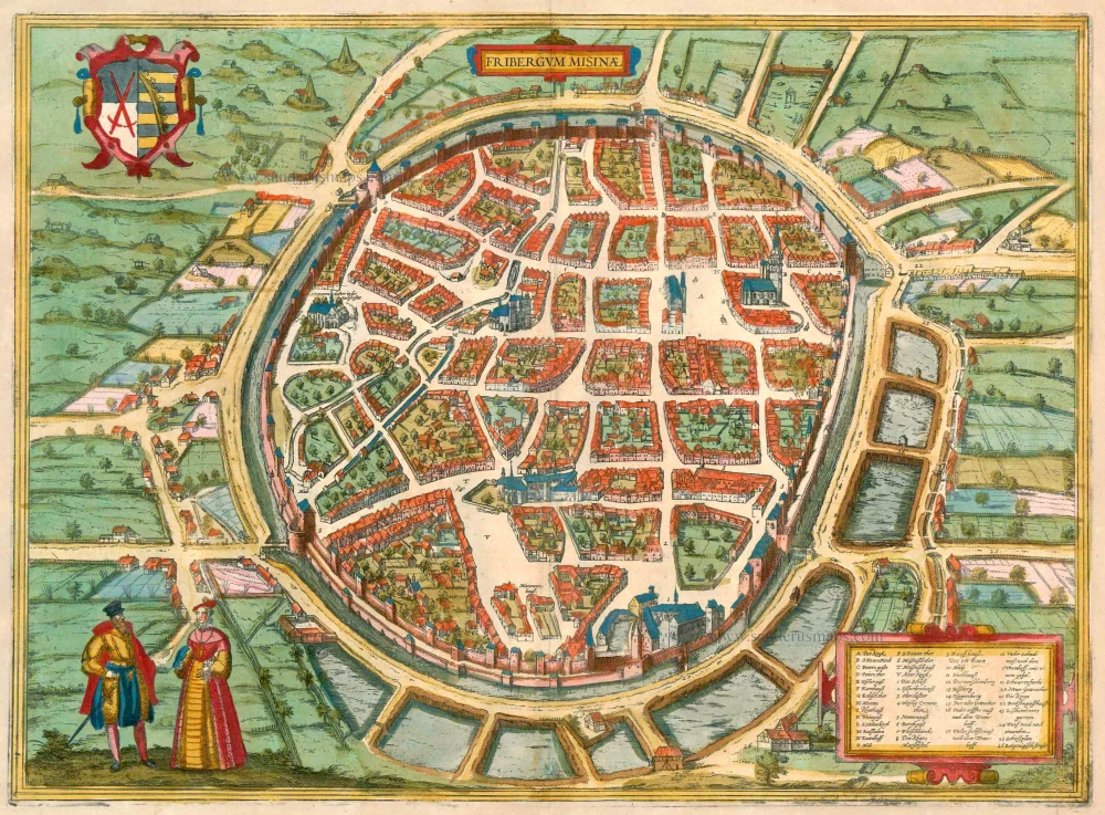


COMMENTARY BY BRAUN (on verso): "Freiberg is a famous and very beautiful mining town near Meissen; it was built where previously two villages stood; one was called Lossnitz, after the stream that flows there. The other village was called Christiansdorf. This town grew up because of the mine, for when a carter carrying salt from Halle to Bohemia found lead ore here and had it examined in Goslar, it contained more silver than lead ore."
This bird's-eye view shows the mining town of Freiberg in Saxony - in 1346, the first free mining town in Germany - with several silver mines in full operation (left). The late Gothic parish church of St Peter (B) can be seen in the upper right-hand corner. To the left of it the town hall dates from the first half of the 15th century (I), further left the big church of St Nicholas, also in the late Gothic style (L), and below the cathedral (Thumkirch). Next to the city wall at the bottom of the plate is the castle of Freudenstein (I), built by Margrave Otto of Meissen in 1168 as a fortress to protect the silver mines that were beginning to flourish at that time. (Taschen)
The engraving is made after a woodcut of Münster's Cosmographia, 1550.
Braun G. & Hogenberg F. and the Civitates Orbis Terrarum.
The Civitates Orbis Terrarum, also known as the 'Braun & Hogenberg', is a six-volume town atlas and the most excellent book of town views and plans ever published: 363 engravings, sometimes beautifully coloured. It was one of the best-selling works in the last quarter of the 16th century. Georg Braun, a skilled writer, wrote the text accompanying the plans and views on the verso. Many plates were engraved after the original drawings of a professional artist, Joris Hoefnagel (1542-1600). The first volume was published in Latin in 1572 and the sixth in 1617. Frans Hogenberg, a talented engraver, created the tables for volumes I through IV, and Simon van den Neuwel made those for volumes V and VI. Other contributors were cartographers Daniel Freese and Heinrich Rantzau, who provided valuable geographical information. Works by Jacob van Deventer, Sebastian Münster, and Johannes Stumpf were also used as references. Translations appeared in German and French, making the atlas accessible to a broader audience.
Since its original publication of volume 1 in 1572, the Civitates Orbis Terrarum has left an indelible mark on the history of cartography. Seven more editions followed the first volume in 1575, 1577, 1582, 1588, 1593, 1599, and 1612. Vol.2, initially released in 1575, saw subsequent editions in 1597 and 1612. The subsequent volumes, each a treasure trove of historical insights, graced the world in 1581, 1588, 1593, 1599, and 1606. The German translation of the first volume, a testament to its widespread appeal, debuted in 1574, followed by the French edition in 1575.
Several printers were involved: Theodor Graminaeus, Heinrich von Aich, Gottfried von Kempen, Johannis Sinniger, Bertram Buchholtz, and Peter von Brachel, all of whom worked in Cologne.
Georg Braun (1541-1622)
Georg Braun, the author of the text accompanying the plans and views in the Civitates Orbis Terrarum, was born in Cologne in 1541. After his studies in Cologne, he entered the Jesuit Order as a novice, indicating his commitment to learning and intellectual pursuits. In 1561, he obtained his bachelor's degree; in 1562, he received his Magister Artium, further demonstrating his academic achievements. Although he left the Jesuit Order, he continued his studies in theology, gaining a licentiate in theology. His theological background likely influenced the content and tone of the text in the Civitates Orbis Terrarum, adding a unique perspective to the work.
Frans Hogenberg (1535-1590)
Frans Hogenberg was a Flemish and German painter, engraver, and mapmaker. He was born in Mechelen as the son of Nicolaas Hogenberg.
By the end of the 1560s, Frans Hogenberg was employed upon Abraham Ortelius's Theatrum Orbis Terrarum, published in 1570; he is named an engraver of numerous maps. In 1568, he was banned from Antwerp by the Duke of Alva and travelled to London, where he stayed a few years before emigrating to Cologne. He immediately embarked on his two most important works, the Civitates, published in 1572 and the Geschichtsblätter, which appeared in several series from 1569 until about 1587.
Thanks to large-scale projects like the Geschichtsblätter and the Civitates, Hogenberg's social circumstances improved with each passing year. He died as a wealthy man in Cologne in 1590.
Fribergum Misinae
Item Number: 23279 Authenticity Guarantee
Category: Antique maps > Europe > Germany - Cities
Old, antique bird’s-eye view plan of Freiberg (Saxony), by Georg Braun and Frans Hogenberg.
Title: Fribergum Misinae.
Date of the first edition: 1575.
Date of this map: 1575-1612.
Copper engraving, printed on paper.
Size (not including margins): 340 x 460mm (13.39 x 18.11 inches).
Verso: Latin text.
Condition: Small hole repaired at lower centrefold, superb old colour.
Condition Rating: A.
From: Civitates Orbis Terrarum, ... Part 2. Köln, 1575-1612.
COMMENTARY BY BRAUN (on verso): "Freiberg is a famous and very beautiful mining town near Meissen; it was built where previously two villages stood; one was called Lossnitz, after the stream that flows there. The other village was called Christiansdorf. This town grew up because of the mine, for when a carter carrying salt from Halle to Bohemia found lead ore here and had it examined in Goslar, it contained more silver than lead ore."
This bird's-eye view shows the mining town of Freiberg in Saxony - in 1346, the first free mining town in Germany - with several silver mines in full operation (left). The late Gothic parish church of St Peter (B) can be seen in the upper right-hand corner. To the left of it the town hall dates from the first half of the 15th century (I), further left the big church of St Nicholas, also in the late Gothic style (L), and below the cathedral (Thumkirch). Next to the city wall at the bottom of the plate is the castle of Freudenstein (I), built by Margrave Otto of Meissen in 1168 as a fortress to protect the silver mines that were beginning to flourish at that time. (Taschen)
The engraving is made after a woodcut of Münster's Cosmographia, 1550.
Braun G. & Hogenberg F. and the Civitates Orbis Terrarum.
The Civitates Orbis Terrarum, also known as the 'Braun & Hogenberg', is a six-volume town atlas and the most excellent book of town views and plans ever published: 363 engravings, sometimes beautifully coloured. It was one of the best-selling works in the last quarter of the 16th century. Georg Braun, a skilled writer, wrote the text accompanying the plans and views on the verso. Many plates were engraved after the original drawings of a professional artist, Joris Hoefnagel (1542-1600). The first volume was published in Latin in 1572 and the sixth in 1617. Frans Hogenberg, a talented engraver, created the tables for volumes I through IV, and Simon van den Neuwel made those for volumes V and VI. Other contributors were cartographers Daniel Freese and Heinrich Rantzau, who provided valuable geographical information. Works by Jacob van Deventer, Sebastian Münster, and Johannes Stumpf were also used as references. Translations appeared in German and French, making the atlas accessible to a broader audience.
Since its original publication of volume 1 in 1572, the Civitates Orbis Terrarum has left an indelible mark on the history of cartography. Seven more editions followed the first volume in 1575, 1577, 1582, 1588, 1593, 1599, and 1612. Vol.2, initially released in 1575, saw subsequent editions in 1597 and 1612. The subsequent volumes, each a treasure trove of historical insights, graced the world in 1581, 1588, 1593, 1599, and 1606. The German translation of the first volume, a testament to its widespread appeal, debuted in 1574, followed by the French edition in 1575.
Several printers were involved: Theodor Graminaeus, Heinrich von Aich, Gottfried von Kempen, Johannis Sinniger, Bertram Buchholtz, and Peter von Brachel, all of whom worked in Cologne.
Georg Braun (1541-1622)
Georg Braun, the author of the text accompanying the plans and views in the Civitates Orbis Terrarum, was born in Cologne in 1541. After his studies in Cologne, he entered the Jesuit Order as a novice, indicating his commitment to learning and intellectual pursuits. In 1561, he obtained his bachelor's degree; in 1562, he received his Magister Artium, further demonstrating his academic achievements. Although he left the Jesuit Order, he continued his studies in theology, gaining a licentiate in theology. His theological background likely influenced the content and tone of the text in the Civitates Orbis Terrarum, adding a unique perspective to the work.
Frans Hogenberg (1535-1590)
Frans Hogenberg was a Flemish and German painter, engraver, and mapmaker. He was born in Mechelen as the son of Nicolaas Hogenberg.
By the end of the 1560s, Frans Hogenberg was employed upon Abraham Ortelius's Theatrum Orbis Terrarum, published in 1570; he is named an engraver of numerous maps. In 1568, he was banned from Antwerp by the Duke of Alva and travelled to London, where he stayed a few years before emigrating to Cologne. He immediately embarked on his two most important works, the Civitates, published in 1572 and the Geschichtsblätter, which appeared in several series from 1569 until about 1587.
Thanks to large-scale projects like the Geschichtsblätter and the Civitates, Hogenberg's social circumstances improved with each passing year. He died as a wealthy man in Cologne in 1590.
Related items
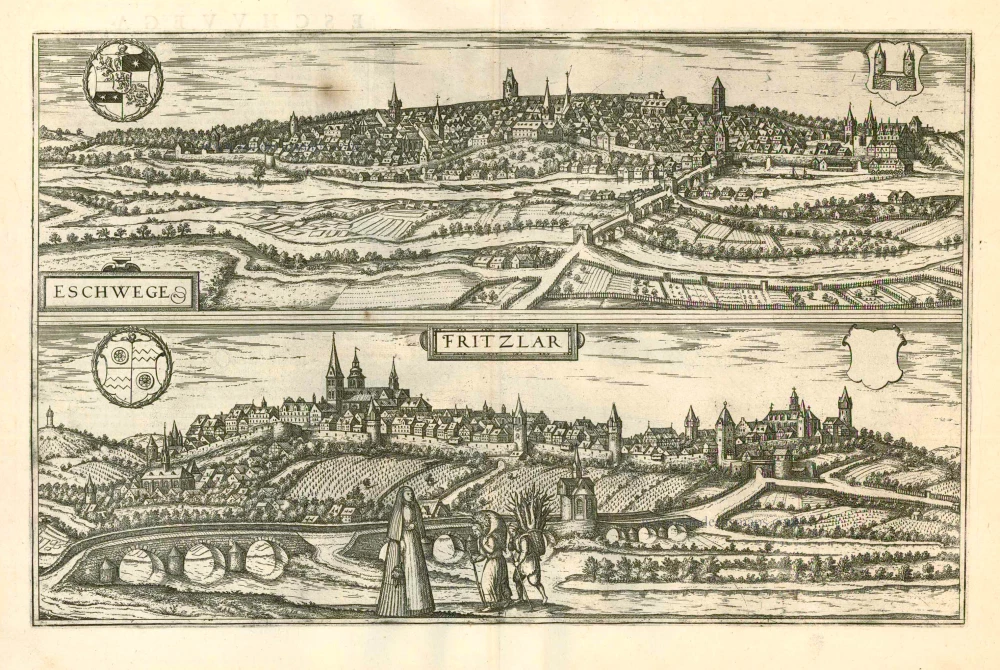
Eschwege [on sheet with] Fritzlar 1599
Eschwege and Fritzlar, by Georg Braun and Frans Hogenberg.
[Item number: 24054]

Dresden - Dresa Florentissimum Misniae Opp. Illust: Saxoniae Ducum Sedes [on sheet with] Leibzigk - Lipsia Litterarum Studiis et Mercatura Celebre Misniae Oppidum. 1582
Dresden and Leipzig, by Georg Braun and Frans Hogenberg.
[Item number: 25502]