
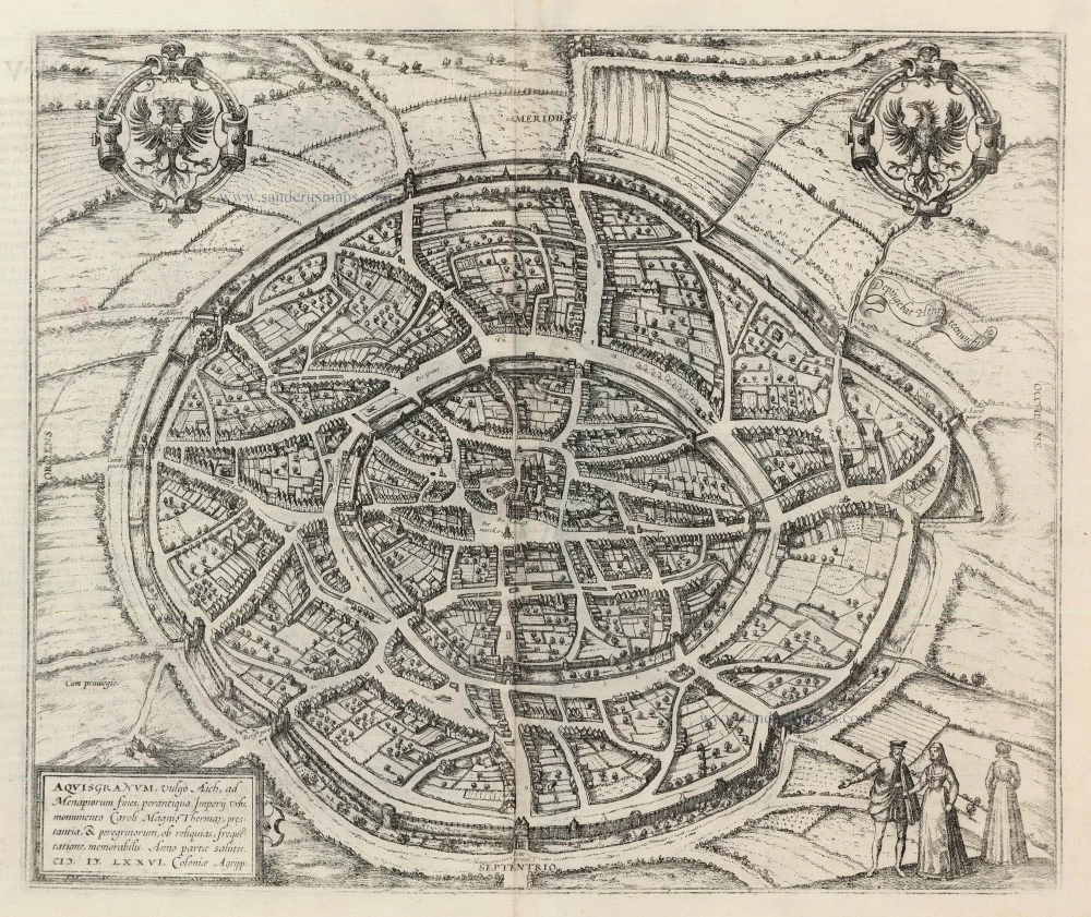
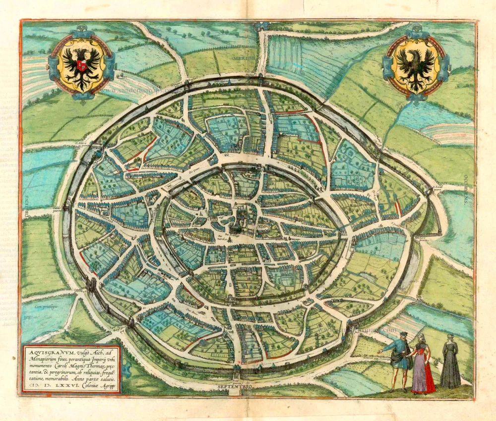
Aachen, by Georg Braun & Frans Hogenberg. 1572

TRANSLATION OF CARTOUCHE TEXT: Aachen, the highly famed city, ranks highest amongst the four imperial cities.
COMMENTARY BY BRAUN: "Carolus, king of the Franks, with the later cognomen Magnus, came here by chance while hunting and was delighted by its thermal springs, its charm and the convenient location of the site, and so he restored it together by its residence and erected a royal palace there. Because he was an exceedingly God-fearing man, he built the splendid chapel at considerable cost on the same spot, next to his imperial palace, and had it consecrated by Leo, Bishop of Rome, in honour of God and the Blessed Virgin Mary and furnished it with rich gifts, chiefly with sacred memorials of steadfast faith, or relics. Because of the relics, he instigated a pilgrimage every seven years, which still occurs today."
Aachen - formerly known as Aix-la-Chapelle - is the first German city to be showcased by Braun and Hogenberg. Even in their era, it was the focus of a remarkable quantity of high-quality maps and views. Aachen, a central figure in the Holy Roman Empire, is significant in history. For this reason, Braun underlines the 'Heiltumsfahrt' (pilgrimage to the sacred relics), the construction of the palace and the Palatine chapel (c.800) and the hot sulphur springs, which the Romans revered. The Old High German word Ahha (Acha) means water; the Romans named the site Aquae Grani, later Aquisgranum, after Grannus, the god of healing. Thirty-two kings were crowned in Aachen, the last being Ferdinand I in 1531. The illustration of Aachen provides a bird's-eye view looking diagonally towards the south. The artist has strategically positioned many buildings to showcase their public façades, and the town hall and cathedral have each been rotated 90 degrees. (Taschen).
Braun G. & Hogenberg F. and the Civitates Orbis Terrarum.
The Civitates Orbis Terrarum, also known as the 'Braun & Hogenberg', is a six-volume town atlas and the most excellent book of town views and plans ever published: 363 engravings, sometimes beautifully coloured. It was one of the best-selling works in the last quarter of the 16th century. Georg Braun, a skilled writer, wrote the text accompanying the plans and views on the verso. Many plates were engraved after the original drawings of a professional artist, Joris Hoefnagel (1542-1600). The first volume was published in Latin in 1572 and the sixth in 1617. Frans Hogenberg, a talented engraver, created the tables for volumes I through IV, and Simon van den Neuwel made those for volumes V and VI. Other contributors were cartographers Daniel Freese and Heinrich Rantzau, who provided valuable geographical information. Works by Jacob van Deventer, Sebastian Münster, and Johannes Stumpf were also used as references. Translations appeared in German and French, making the atlas accessible to a broader audience.
Since its original publication of volume 1 in 1572, the Civitates Orbis Terrarum has left an indelible mark on the history of cartography. Seven more editions followed the first volume in 1575, 1577, 1582, 1588, 1593, 1599, and 1612. Vol.2, initially released in 1575, saw subsequent editions in 1597 and 1612. The subsequent volumes, each a treasure trove of historical insights, graced the world in 1581, 1588, 1593, 1599, and 1606. The German translation of the first volume, a testament to its widespread appeal, debuted in 1574, followed by the French edition in 1575.
Several printers were involved: Theodor Graminaeus, Heinrich von Aich, Gottfried von Kempen, Johannis Sinniger, Bertram Buchholtz, and Peter von Brachel, all of whom worked in Cologne.
Georg Braun (1541-1622)
Georg Braun, the author of the text accompanying the plans and views in the Civitates Orbis Terrarum, was born in Cologne in 1541. After his studies in Cologne, he entered the Jesuit Order as a novice, indicating his commitment to learning and intellectual pursuits. In 1561, he obtained his bachelor's degree; in 1562, he received his Magister Artium, further demonstrating his academic achievements. Although he left the Jesuit Order, he continued his studies in theology, gaining a licentiate in theology. His theological background likely influenced the content and tone of the text in the Civitates Orbis Terrarum, adding a unique perspective to the work.
Frans Hogenberg (1535-1590)
Frans Hogenberg was a Flemish and German painter, engraver, and mapmaker. He was born in Mechelen as the son of Nicolaas Hogenberg.
By the end of the 1560s, Frans Hogenberg was employed upon Abraham Ortelius's Theatrum Orbis Terrarum, published in 1570; he is named an engraver of numerous maps. In 1568, he was banned from Antwerp by the Duke of Alva and travelled to London, where he stayed a few years before emigrating to Cologne. He immediately embarked on his two most important works, the Civitates, published in 1572 and the Geschichtsblätter, which appeared in several series from 1569 until about 1587.
Thanks to large-scale projects like the Geschichtsblätter and the Civitates, Hogenberg's social circumstances improved with each passing year. He died as a wealthy man in Cologne in 1590.
Aich - Aquisgranum, Urbs Prae Clarissima, Primum, Inter Quatuor Imperii Civitates, Locum Obtinet.
Item Number: 9173 Authenticity Guarantee
Category: Antique maps > Europe > Germany - Cities
Aachen, by Georg Braun & Frans Hogenberg.
Title: Aich - Aquisgranum, Urbs Prae Clarissima, Primum, Inter Quatuor Imperii Civitates, Locum Obtinet.
Date of the first edition: 1572.
Date of this map: 1572.
Copper engraving, printed on paper.
Image size: 325 x 385mm (12.8 x 15.16 inches).
Sheet size: 380 x 525mm (14.96 x 20.67 inches).
Verso: Latin text.
Condition: Original coloured, margins stained.
Condition Rating: A.
From: Civitates Orbis Terrarum, Liber Primus. Cologne, Theodor Graminaeus, 1572. (Van der Krogt 4, 41:0)
TRANSLATION OF CARTOUCHE TEXT: Aachen, the highly famed city, ranks highest amongst the four imperial cities.
COMMENTARY BY BRAUN: "Carolus, king of the Franks, with the later cognomen Magnus, came here by chance while hunting and was delighted by its thermal springs, its charm and the convenient location of the site, and so he restored it together by its residence and erected a royal palace there. Because he was an exceedingly God-fearing man, he built the splendid chapel at considerable cost on the same spot, next to his imperial palace, and had it consecrated by Leo, Bishop of Rome, in honour of God and the Blessed Virgin Mary and furnished it with rich gifts, chiefly with sacred memorials of steadfast faith, or relics. Because of the relics, he instigated a pilgrimage every seven years, which still occurs today."
Aachen - formerly known as Aix-la-Chapelle - is the first German city to be showcased by Braun and Hogenberg. Even in their era, it was the focus of a remarkable quantity of high-quality maps and views. Aachen, a central figure in the Holy Roman Empire, is significant in history. For this reason, Braun underlines the 'Heiltumsfahrt' (pilgrimage to the sacred relics), the construction of the palace and the Palatine chapel (c.800) and the hot sulphur springs, which the Romans revered. The Old High German word Ahha (Acha) means water; the Romans named the site Aquae Grani, later Aquisgranum, after Grannus, the god of healing. Thirty-two kings were crowned in Aachen, the last being Ferdinand I in 1531. The illustration of Aachen provides a bird's-eye view looking diagonally towards the south. The artist has strategically positioned many buildings to showcase their public façades, and the town hall and cathedral have each been rotated 90 degrees. (Taschen).
Braun G. & Hogenberg F. and the Civitates Orbis Terrarum.
The Civitates Orbis Terrarum, also known as the 'Braun & Hogenberg', is a six-volume town atlas and the most excellent book of town views and plans ever published: 363 engravings, sometimes beautifully coloured. It was one of the best-selling works in the last quarter of the 16th century. Georg Braun, a skilled writer, wrote the text accompanying the plans and views on the verso. Many plates were engraved after the original drawings of a professional artist, Joris Hoefnagel (1542-1600). The first volume was published in Latin in 1572 and the sixth in 1617. Frans Hogenberg, a talented engraver, created the tables for volumes I through IV, and Simon van den Neuwel made those for volumes V and VI. Other contributors were cartographers Daniel Freese and Heinrich Rantzau, who provided valuable geographical information. Works by Jacob van Deventer, Sebastian Münster, and Johannes Stumpf were also used as references. Translations appeared in German and French, making the atlas accessible to a broader audience.
Since its original publication of volume 1 in 1572, the Civitates Orbis Terrarum has left an indelible mark on the history of cartography. Seven more editions followed the first volume in 1575, 1577, 1582, 1588, 1593, 1599, and 1612. Vol.2, initially released in 1575, saw subsequent editions in 1597 and 1612. The subsequent volumes, each a treasure trove of historical insights, graced the world in 1581, 1588, 1593, 1599, and 1606. The German translation of the first volume, a testament to its widespread appeal, debuted in 1574, followed by the French edition in 1575.
Several printers were involved: Theodor Graminaeus, Heinrich von Aich, Gottfried von Kempen, Johannis Sinniger, Bertram Buchholtz, and Peter von Brachel, all of whom worked in Cologne.
Georg Braun (1541-1622)
Georg Braun, the author of the text accompanying the plans and views in the Civitates Orbis Terrarum, was born in Cologne in 1541. After his studies in Cologne, he entered the Jesuit Order as a novice, indicating his commitment to learning and intellectual pursuits. In 1561, he obtained his bachelor's degree; in 1562, he received his Magister Artium, further demonstrating his academic achievements. Although he left the Jesuit Order, he continued his studies in theology, gaining a licentiate in theology. His theological background likely influenced the content and tone of the text in the Civitates Orbis Terrarum, adding a unique perspective to the work.
Frans Hogenberg (1535-1590)
Frans Hogenberg was a Flemish and German painter, engraver, and mapmaker. He was born in Mechelen as the son of Nicolaas Hogenberg.
By the end of the 1560s, Frans Hogenberg was employed upon Abraham Ortelius's Theatrum Orbis Terrarum, published in 1570; he is named an engraver of numerous maps. In 1568, he was banned from Antwerp by the Duke of Alva and travelled to London, where he stayed a few years before emigrating to Cologne. He immediately embarked on his two most important works, the Civitates, published in 1572 and the Geschichtsblätter, which appeared in several series from 1569 until about 1587.
Thanks to large-scale projects like the Geschichtsblätter and the Civitates, Hogenberg's social circumstances improved with each passing year. He died as a wealthy man in Cologne in 1590.
Related items
Aquisgranum, vulgo Aich, ad Menapiorum fines, perantiqua Imperij Urbs, M0onumento Caroli Magni, ... 1599
Aachen, by Georg Braun and Frans Hogenberg.
[Item number: 23907]
Rare
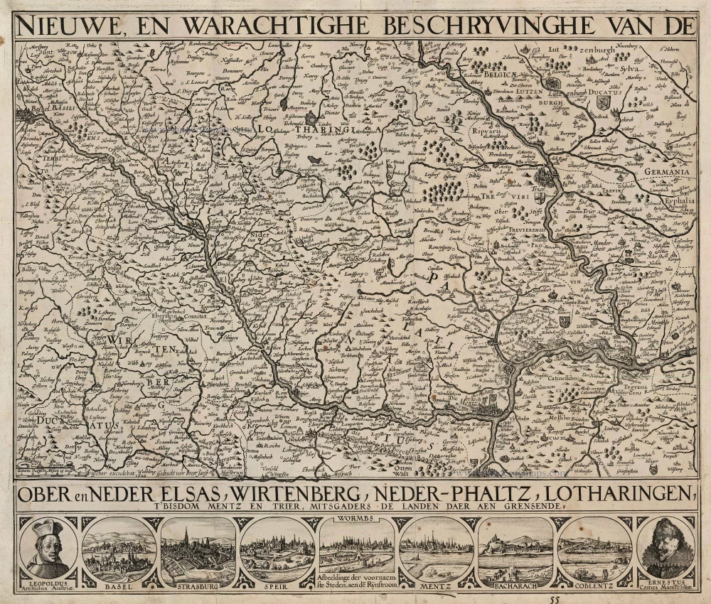
Nieuwe, en Warachtighe Beschryvinghe van de Ober en Neder Elsas, Wirtenberg, Neder-Phaltz, Lotharingen, t'Bisdom Mentz en Trier, mitsgaders de Landen daer aen grensende. 1630
Alsace, by C.J. Visscher and J. Janssonius.
[Item number: 24502]
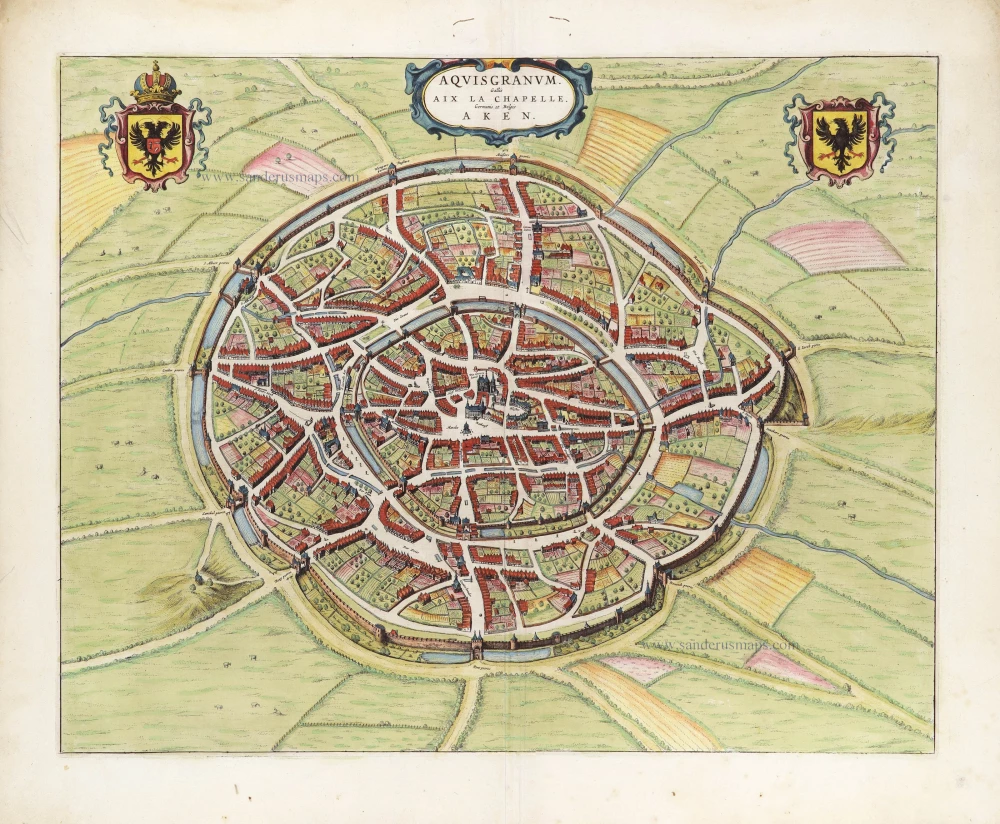
Aquisgranum, vulgo Aich, ad Menapiorum fines, perantiqua Imperij Urbs, Monumento Caroli Magni, Thermar prestantia, & peregrinorum, ob reliquias, frequetatione, memorabilis. Anno partae salutis. M.D.LXXVI. Coloniae Agripp: 1582
Aachen by Braun & Hogenberg
[Item number: 25488]
Aquisgranum Gallis Aix La Chapelle Germanis et Belgis Aken. 1649
Aachen, by Joan Blaeu.
[Item number: 28940]