Budingen, by Braun & Hogenberg. 1617


TRANSLATION OF CARTOUCHE TEXT: God gave every land its gifts in 1617.
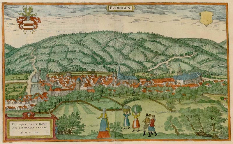
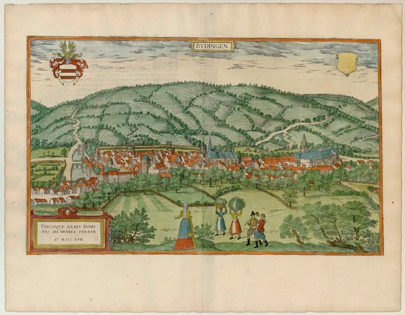
COMMENTARY BY BRAUN: "This is a fine handsome city; it lies on the Kinzig, which flows into the Main. It is part of the area belonging to the Counts of Ysenburg, who call themselves the lords of Büdingen and have a great castle and court. The surrounding mountains are full of fruitful vines; there are also impressive vegetable gardens, orchards, and fine pastures so that nothing is lacking here that is needed for human nourishment, except that much sweat and labour are required to produce it from the soil."
The view shows a city surrounded by vineyards and well-fortified with walls and moats. On the right is the castle with its keep. Seen from a high viewpoint in the south, the houses in the city are crowded together, with the late Gothic church of St Mary standing out in the middle. The figures in the foreground reference the status of the town: the burgher woman with a hood is shown by her standing with a ruff and full-length skirt, but her apron indicates that she is hard working. The maids, with their dresses tucked up for work and carrying the harvest on their heads, symbolise the fertility of the soil, while the men carrying a prong-hoe and an axe represent the toil in the fields.
Braun G. & Hogenberg F. and the Civitates Orbis Terrarum.
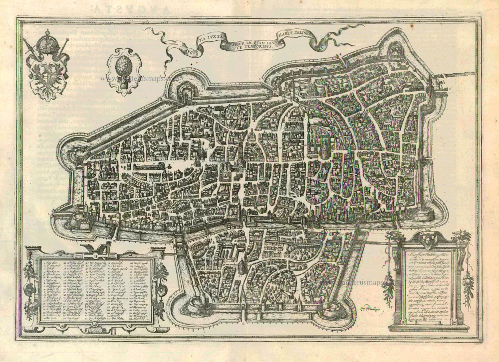
The Civitates Orbis Terrarum, also known as the 'Braun & Hogenberg', is a six-volume town atlas and the most excellent book of town views and plans ever published: 363 engravings, sometimes beautifully coloured. It was one of the best-selling works in the last quarter of the 16th century. Georg Braun, a skilled writer, wrote the text accompanying the plans and views on the verso. Many plates were engraved after the original drawings of a professional artist, Joris Hoefnagel (1542-1600). The first volume was published in Latin in 1572 and the sixth in 1617. Frans Hogenberg, a talented engraver, created the tables for volumes I through IV, and Simon van den Neuwel made those for volumes V and VI. Other contributors were cartographers Daniel Freese and Heinrich Rantzau, who provided valuable geographical information. Works by Jacob van Deventer, Sebastian Münster, and Johannes Stumpf were also used as references. Translations appeared in German and French, making the atlas accessible to a broader audience.
Since its original publication of volume 1 in 1572, the Civitates Orbis Terrarum has left an indelible mark on the history of cartography. Seven more editions followed the first volume in 1575, 1577, 1582, 1588, 1593, 1599, and 1612. Vol.2, initially released in 1575, saw subsequent editions in 1597 and 1612. The subsequent volumes, each a treasure trove of historical insights, graced the world in 1581, 1588, 1593, 1599, and 1606. The German translation of the first volume, a testament to its widespread appeal, debuted in 1574, followed by the French edition in 1575.
Several printers were involved: Theodor Graminaeus, Heinrich von Aich, Gottfried von Kempen, Johannis Sinniger, Bertram Buchholtz, and Peter von Brachel, all of whom worked in Cologne.
Georg Braun (1541-1622)
Georg Braun, the author of the text accompanying the plans and views in the Civitates Orbis Terrarum, was born in Cologne in 1541. After his studies in Cologne, he entered the Jesuit Order as a novice, indicating his commitment to learning and intellectual pursuits. In 1561, he obtained his bachelor's degree; in 1562, he received his Magister Artium, further demonstrating his academic achievements. Although he left the Jesuit Order, he continued his studies in theology, gaining a licentiate in theology. His theological background likely influenced the content and tone of the text in the Civitates Orbis Terrarum, adding a unique perspective to the work.
Frans Hogenberg (1535-1590)
Frans Hogenberg was a Flemish and German painter, engraver, and mapmaker. He was born in Mechelen as the son of Nicolaas Hogenberg.
By the end of the 1560s, Frans Hogenberg was employed upon Abraham Ortelius's Theatrum Orbis Terrarum, published in 1570; he is named an engraver of numerous maps. In 1568, he was banned from Antwerp by the Duke of Alva and travelled to London, where he stayed a few years before emigrating to Cologne. He immediately embarked on his two most important works, the Civitates, published in 1572 and the Geschichtsblätter, which appeared in several series from 1569 until about 1587.
Thanks to large-scale projects like the Geschichtsblätter and the Civitates, Hogenberg's social circumstances improved with each passing year. He died as a wealthy man in Cologne in 1590.
Budingen.
Currently not available
Item Number: 22133 Authenticity Guarantee
Category: Antique maps > Europe > Germany - Cities
Antique view of Budingen by Braun & Hogenberg.
Title: Budingen.
Date: 1617.
Copper engraving, printed on paper.
Size (not including margins): 300 x 490mm (11.81 x 19.29 inches).
Verso: Latin text.
Condition: Original coloured, excellent.
Condition Rating: A+.
From: Theatri praecipuarum Totius Mundi Urbium Liber Sextus Anno MDCXVII. (Koeman, B&H6)
TRANSLATION OF CARTOUCHE TEXT: God gave every land its gifts in 1617.
COMMENTARY BY BRAUN: "This is a fine handsome city; it lies on the Kinzig, which flows into the Main. It is part of the area belonging to the Counts of Ysenburg, who call themselves the lords of Büdingen and have a great castle and court. The surrounding mountains are full of fruitful vines; there are also impressive vegetable gardens, orchards, and fine pastures so that nothing is lacking here that is needed for human nourishment, except that much sweat and labour are required to produce it from the soil."
The view shows a city surrounded by vineyards and well-fortified with walls and moats. On the right is the castle with its keep. Seen from a high viewpoint in the south, the houses in the city are crowded together, with the late Gothic church of St Mary standing out in the middle. The figures in the foreground reference the status of the town: the burgher woman with a hood is shown by her standing with a ruff and full-length skirt, but her apron indicates that she is hard working. The maids, with their dresses tucked up for work and carrying the harvest on their heads, symbolise the fertility of the soil, while the men carrying a prong-hoe and an axe represent the toil in the fields.
Braun G. & Hogenberg F. and the Civitates Orbis Terrarum.
The Civitates Orbis Terrarum, also known as the 'Braun & Hogenberg', is a six-volume town atlas and the most excellent book of town views and plans ever published: 363 engravings, sometimes beautifully coloured. It was one of the best-selling works in the last quarter of the 16th century. Georg Braun, a skilled writer, wrote the text accompanying the plans and views on the verso. Many plates were engraved after the original drawings of a professional artist, Joris Hoefnagel (1542-1600). The first volume was published in Latin in 1572 and the sixth in 1617. Frans Hogenberg, a talented engraver, created the tables for volumes I through IV, and Simon van den Neuwel made those for volumes V and VI. Other contributors were cartographers Daniel Freese and Heinrich Rantzau, who provided valuable geographical information. Works by Jacob van Deventer, Sebastian Münster, and Johannes Stumpf were also used as references. Translations appeared in German and French, making the atlas accessible to a broader audience.
Since its original publication of volume 1 in 1572, the Civitates Orbis Terrarum has left an indelible mark on the history of cartography. Seven more editions followed the first volume in 1575, 1577, 1582, 1588, 1593, 1599, and 1612. Vol.2, initially released in 1575, saw subsequent editions in 1597 and 1612. The subsequent volumes, each a treasure trove of historical insights, graced the world in 1581, 1588, 1593, 1599, and 1606. The German translation of the first volume, a testament to its widespread appeal, debuted in 1574, followed by the French edition in 1575.
Several printers were involved: Theodor Graminaeus, Heinrich von Aich, Gottfried von Kempen, Johannis Sinniger, Bertram Buchholtz, and Peter von Brachel, all of whom worked in Cologne.
Georg Braun (1541-1622)
Georg Braun, the author of the text accompanying the plans and views in the Civitates Orbis Terrarum, was born in Cologne in 1541. After his studies in Cologne, he entered the Jesuit Order as a novice, indicating his commitment to learning and intellectual pursuits. In 1561, he obtained his bachelor's degree; in 1562, he received his Magister Artium, further demonstrating his academic achievements. Although he left the Jesuit Order, he continued his studies in theology, gaining a licentiate in theology. His theological background likely influenced the content and tone of the text in the Civitates Orbis Terrarum, adding a unique perspective to the work.
Frans Hogenberg (1535-1590)
Frans Hogenberg was a Flemish and German painter, engraver, and mapmaker. He was born in Mechelen as the son of Nicolaas Hogenberg.
By the end of the 1560s, Frans Hogenberg was employed upon Abraham Ortelius's Theatrum Orbis Terrarum, published in 1570; he is named an engraver of numerous maps. In 1568, he was banned from Antwerp by the Duke of Alva and travelled to London, where he stayed a few years before emigrating to Cologne. He immediately embarked on his two most important works, the Civitates, published in 1572 and the Geschichtsblätter, which appeared in several series from 1569 until about 1587.
Thanks to large-scale projects like the Geschichtsblätter and the Civitates, Hogenberg's social circumstances improved with each passing year. He died as a wealthy man in Cologne in 1590.