
Heilbronn - Mulhouse - Reutlingen by Braun & Hogenberg 1617
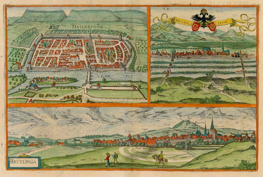


HEILBRONN
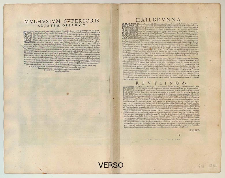
COMMENTARY BY BRAUN (on verso): "Several believe that the name of this city is Heldenbrunn, but others call it Hellbrunn because of the healthy and healing water that is found here. It grew from a village into a town and was surrounded with walls in the year 1082 or, as claimed by some, in the year 1285 and was granted a municipal charter by Emperor Frederick II."
This is a view from the west over the Neckar of the fortified city centre with the larger-than-life-size church of St Kilian. On the marketplace's northwest of it is the town hall with the famous ornate clock by Isaak Habrecht of Strasbourg. The city is surrounded by orchards and vegetable gardens, fields and vineyards. Unfortunately, very few of Heilbronn's historic buildings are still standing today, for the Old Town was almost completely destroyed in the Second World War.
MULHOUSE IN ALSACE
COMMENTARY BY BRAUN (on verso): "As far as this city is concerned, it is very well fortified and protected by nature and its surroundings as well as by thick walls, ditches and similar constructions, in particular, there are four moats and over each a bridge that must be crossed before one can enter the city. The soil in the surrounding countryside produces corn and wine and all kinds of fruit in great abundance."
From a slightly raised position, this view from the west shows the city behind its four moats. The late Romanesque church of St Stephen dates from the 12th century. In the background, the Vosges Mountains can be seen. Mulhouse was once a Free Imperial City and was associated with the Old Swiss Confederacy for a long time.
REUTLINGEN
COMMENTARY BY BRAUN (on verso): "The position of this city is ideal for various industries, there are numerous mills, and a great deal of paper is made and exported far and wide. The city has engaged in many battles with the Counts and Dukes of Württemberg, and a. Although it often suffered no little damage, it has not only defended and safeguarded its liberties and rights with the aid of its allies and neighbouring cities but ha. Still, it has defeated the enemy more than once."
This view from the southwest shows a well-fortified city, behind which vineyards and the dominant cone-shaped Achalm Hill with the imperial castle can be seen. Reutlingen, which was granted a municipal charter in 1209, became an important centre of trade and craft industries, including book printing. During a period of great prosperity (13th-14th cent.), the magnificent Gothic church of St Mary was built, a proud symbol of the status of Reutlingen was involved in various armed conflicts during the 16th century.
Braun G. & Hogenberg F. and the Civitates Orbis Terrarum.
The Civitates Orbis Terrarum, also known as the 'Braun & Hogenberg', is a six-volume town atlas and the most excellent book of town views and plans ever published: 363 engravings, sometimes beautifully coloured. It was one of the best-selling works in the last quarter of the 16th century. Georg Braun, a skilled writer, wrote the text accompanying the plans and views on the verso. Many plates were engraved after the original drawings of a professional artist, Joris Hoefnagel (1542-1600). The first volume was published in Latin in 1572 and the sixth in 1617. Frans Hogenberg, a talented engraver, created the tables for volumes I through IV, and Simon van den Neuwel made those for volumes V and VI. Other contributors were cartographers Daniel Freese and Heinrich Rantzau, who provided valuable geographical information. Works by Jacob van Deventer, Sebastian Münster, and Johannes Stumpf were also used as references. Translations appeared in German and French, making the atlas accessible to a broader audience.
Since its original publication of volume 1 in 1572, the Civitates Orbis Terrarum has left an indelible mark on the history of cartography. Seven more editions followed the first volume in 1575, 1577, 1582, 1588, 1593, 1599, and 1612. Vol.2, initially released in 1575, saw subsequent editions in 1597 and 1612. The subsequent volumes, each a treasure trove of historical insights, graced the world in 1581, 1588, 1593, 1599, and 1606. The German translation of the first volume, a testament to its widespread appeal, debuted in 1574, followed by the French edition in 1575.
Several printers were involved: Theodor Graminaeus, Heinrich von Aich, Gottfried von Kempen, Johannis Sinniger, Bertram Buchholtz, and Peter von Brachel, all of whom worked in Cologne.
Georg Braun (1541-1622)
Georg Braun, the author of the text accompanying the plans and views in the Civitates Orbis Terrarum, was born in Cologne in 1541. After his studies in Cologne, he entered the Jesuit Order as a novice, indicating his commitment to learning and intellectual pursuits. In 1561, he obtained his bachelor's degree; in 1562, he received his Magister Artium, further demonstrating his academic achievements. Although he left the Jesuit Order, he continued his studies in theology, gaining a licentiate in theology. His theological background likely influenced the content and tone of the text in the Civitates Orbis Terrarum, adding a unique perspective to the work.
Frans Hogenberg (1535-1590)
Frans Hogenberg was a Flemish and German painter, engraver, and mapmaker. He was born in Mechelen as the son of Nicolaas Hogenberg.
By the end of the 1560s, Frans Hogenberg was employed upon Abraham Ortelius's Theatrum Orbis Terrarum, published in 1570; he is named an engraver of numerous maps. In 1568, he was banned from Antwerp by the Duke of Alva and travelled to London, where he stayed a few years before emigrating to Cologne. He immediately embarked on his two most important works, the Civitates, published in 1572 and the Geschichtsblätter, which appeared in several series from 1569 until about 1587.
Thanks to large-scale projects like the Geschichtsblätter and the Civitates, Hogenberg's social circumstances improved with each passing year. He died as a wealthy man in Cologne in 1590.
Hailbrunna [on sheet with:] Mulhusium [and] Reutlinga
Item Number: 22136 Authenticity Guarantee
Category: Antique maps > Europe > Germany - Cities
Antique print with three bird's-eye views by Georg Braun and Frans Hogenberg: Heilbronn, Mulhouse and Reutlingen.
Title: Hailbrunna [on sheet with:] Mulhusium [and] Reutlinga
Date of the first edition: 1617.
Date of this map: 1617.
Copper engraving, printed on paper.
Size (not including margins): 310 x 478mm (12.2 x 18.82 inches).
Verso: Latin text.
Condition: Original coloured, excellent.
Condition Rating: .
References: Van der Krogt 4, 1754; Taschen, Br. Hog., p. 454; Fauser, #5595 #9243, #11658
From: Theatri praecipuarum Totius Mundi Urbium Liber Sextus Anno MDCXVII. (Koeman, B&H6)
HEILBRONN
COMMENTARY BY BRAUN (on verso): "Several believe that the name of this city is Heldenbrunn, but others call it Hellbrunn because of the healthy and healing water that is found here. It grew from a village into a town and was surrounded with walls in the year 1082 or, as claimed by some, in the year 1285 and was granted a municipal charter by Emperor Frederick II."
This is a view from the west over the Neckar of the fortified city centre with the larger-than-life-size church of St Kilian. On the marketplace's northwest of it is the town hall with the famous ornate clock by Isaak Habrecht of Strasbourg. The city is surrounded by orchards and vegetable gardens, fields and vineyards. Unfortunately, very few of Heilbronn's historic buildings are still standing today, for the Old Town was almost completely destroyed in the Second World War.
MULHOUSE IN ALSACE
COMMENTARY BY BRAUN (on verso): "As far as this city is concerned, it is very well fortified and protected by nature and its surroundings as well as by thick walls, ditches and similar constructions, in particular, there are four moats and over each a bridge that must be crossed before one can enter the city. The soil in the surrounding countryside produces corn and wine and all kinds of fruit in great abundance."
From a slightly raised position, this view from the west shows the city behind its four moats. The late Romanesque church of St Stephen dates from the 12th century. In the background, the Vosges Mountains can be seen. Mulhouse was once a Free Imperial City and was associated with the Old Swiss Confederacy for a long time.
REUTLINGEN
COMMENTARY BY BRAUN (on verso): "The position of this city is ideal for various industries, there are numerous mills, and a great deal of paper is made and exported far and wide. The city has engaged in many battles with the Counts and Dukes of Württemberg, and a. Although it often suffered no little damage, it has not only defended and safeguarded its liberties and rights with the aid of its allies and neighbouring cities but ha. Still, it has defeated the enemy more than once."
This view from the southwest shows a well-fortified city, behind which vineyards and the dominant cone-shaped Achalm Hill with the imperial castle can be seen. Reutlingen, which was granted a municipal charter in 1209, became an important centre of trade and craft industries, including book printing. During a period of great prosperity (13th-14th cent.), the magnificent Gothic church of St Mary was built, a proud symbol of the status of Reutlingen was involved in various armed conflicts during the 16th century.
Braun G. & Hogenberg F. and the Civitates Orbis Terrarum.
The Civitates Orbis Terrarum, also known as the 'Braun & Hogenberg', is a six-volume town atlas and the most excellent book of town views and plans ever published: 363 engravings, sometimes beautifully coloured. It was one of the best-selling works in the last quarter of the 16th century. Georg Braun, a skilled writer, wrote the text accompanying the plans and views on the verso. Many plates were engraved after the original drawings of a professional artist, Joris Hoefnagel (1542-1600). The first volume was published in Latin in 1572 and the sixth in 1617. Frans Hogenberg, a talented engraver, created the tables for volumes I through IV, and Simon van den Neuwel made those for volumes V and VI. Other contributors were cartographers Daniel Freese and Heinrich Rantzau, who provided valuable geographical information. Works by Jacob van Deventer, Sebastian Münster, and Johannes Stumpf were also used as references. Translations appeared in German and French, making the atlas accessible to a broader audience.
Since its original publication of volume 1 in 1572, the Civitates Orbis Terrarum has left an indelible mark on the history of cartography. Seven more editions followed the first volume in 1575, 1577, 1582, 1588, 1593, 1599, and 1612. Vol.2, initially released in 1575, saw subsequent editions in 1597 and 1612. The subsequent volumes, each a treasure trove of historical insights, graced the world in 1581, 1588, 1593, 1599, and 1606. The German translation of the first volume, a testament to its widespread appeal, debuted in 1574, followed by the French edition in 1575.
Several printers were involved: Theodor Graminaeus, Heinrich von Aich, Gottfried von Kempen, Johannis Sinniger, Bertram Buchholtz, and Peter von Brachel, all of whom worked in Cologne.
Georg Braun (1541-1622)
Georg Braun, the author of the text accompanying the plans and views in the Civitates Orbis Terrarum, was born in Cologne in 1541. After his studies in Cologne, he entered the Jesuit Order as a novice, indicating his commitment to learning and intellectual pursuits. In 1561, he obtained his bachelor's degree; in 1562, he received his Magister Artium, further demonstrating his academic achievements. Although he left the Jesuit Order, he continued his studies in theology, gaining a licentiate in theology. His theological background likely influenced the content and tone of the text in the Civitates Orbis Terrarum, adding a unique perspective to the work.
Frans Hogenberg (1535-1590)
Frans Hogenberg was a Flemish and German painter, engraver, and mapmaker. He was born in Mechelen as the son of Nicolaas Hogenberg.
By the end of the 1560s, Frans Hogenberg was employed upon Abraham Ortelius's Theatrum Orbis Terrarum, published in 1570; he is named an engraver of numerous maps. In 1568, he was banned from Antwerp by the Duke of Alva and travelled to London, where he stayed a few years before emigrating to Cologne. He immediately embarked on his two most important works, the Civitates, published in 1572 and the Geschichtsblätter, which appeared in several series from 1569 until about 1587.
Thanks to large-scale projects like the Geschichtsblätter and the Civitates, Hogenberg's social circumstances improved with each passing year. He died as a wealthy man in Cologne in 1590.