Leipzig, by Braun and Hogenberg. 1617
The item displayed on this page has been sold. However, we have a similar map in stock:
Leipzig by Georg Braun & Frans Hogenberg 1618
Lipsiae Insignis Saxoniae Urbis et Celeberrimi...
[Item number: 23422]

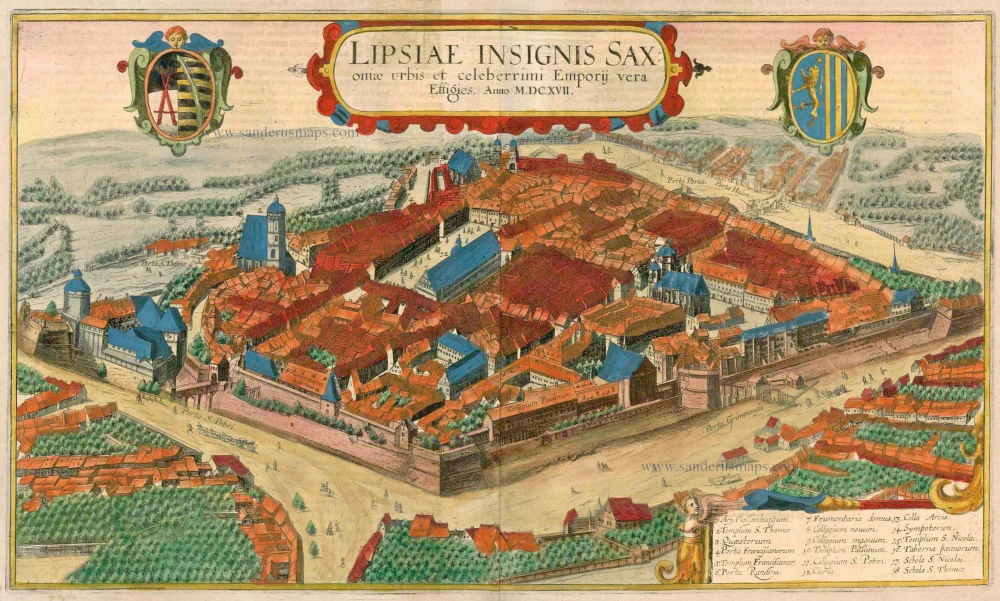

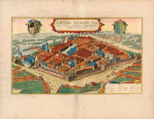

TRANSLATION OF CARTOUCHE TEXT: True likeness of the highly famed market city of Leipzig in Saxony. In the year 1617.
COMMENTARY BY BRAUN: "Leipzig is the capital of the Margravate of Meissen and lies at the confluence of the Elster and the Pleisse. It has two handsome parish churches, two elementary schools, a court of lay assessors and a regional court. A particular embellishment of the city is the university. First, however, I must warn students who are considering coming here. Not long ago, a nobleman came to Leipzig and enquired about his cousin and whether he was applying himself assiduously to his studies. A fellow student answered that he was holding his own very well, for among the 1,500 students, no one could drink better than him. But this is a bad reputation, especially unbecoming for a student."
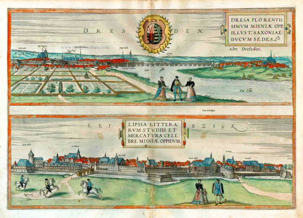
The first plate of Leipzig shows the city around 1570 from a shallow position, with three horse riders in the left foreground as a reference to the horse market. After receiving market privileges in 1165, Leipzig developed into a leading trade-fair centre, achieving fame across Europe after being awarded imperial trade-fair rights in 1497.
This second plate, executed 50 years later, is an unusual combination of a cavalier perspective and a bird's-eye view. As a result, the viewer has the feeling of floating above the roofs. This plate is based on an official drawing by Konrad Knobloch commissioned by the Leipzig City Council. This explains why churches, public buildings, and townhouses are accurately represented with architectural details. Shortly before the first plate, there had been significant changes in Leipzig's buildings. After the siege and destruction of parts of the fortifications in 1547, a new fortress was begun under Elector Maurice of Saxony. This project culminated in the newly built Pleissenburg castle. In the 16th and 17th centuries, Leipzig was a medium-sized city with a university (visible on the right), founded in 1408-9 by scholars who had left the University of Prague. In 1620, it had a population of around 15,000. From the end of the 15th century, Leipzig was also a printing and publishing industry centre. In addition, the city played an essential role in the Reformation, for the "Leipzig Disputation", a debate at Pleissenburg castle in the summer of 1519 amongst Johannes Eck, Andreas Karlstadt, Philipp Melanchton and Martin Luther, sealed Luther's final break with the papacy.
Manasse Steinberg makes the engraving after a drawing by Konrad Knobloch. (Taschen)
Braun G. & Hogenberg F. and the Civitates Orbis Terrarum.
The Civitates Orbis Terrarum, also known as the 'Braun & Hogenberg', is a six-volume town atlas and the most excellent book of town views and plans ever published: 363 engravings, sometimes beautifully coloured. It was one of the best-selling works in the last quarter of the 16th century. Georg Braun, a skilled writer, wrote the text accompanying the plans and views on the verso. Many plates were engraved after the original drawings of a professional artist, Joris Hoefnagel (1542-1600). The first volume was published in Latin in 1572 and the sixth in 1617. Frans Hogenberg, a talented engraver, created the tables for volumes I through IV, and Simon van den Neuwel made those for volumes V and VI. Other contributors were cartographers Daniel Freese and Heinrich Rantzau, who provided valuable geographical information. Works by Jacob van Deventer, Sebastian Münster, and Johannes Stumpf were also used as references. Translations appeared in German and French, making the atlas accessible to a broader audience.
Since its original publication of volume 1 in 1572, the Civitates Orbis Terrarum has left an indelible mark on the history of cartography. Seven more editions followed the first volume in 1575, 1577, 1582, 1588, 1593, 1599, and 1612. Vol.2, initially released in 1575, saw subsequent editions in 1597 and 1612. The subsequent volumes, each a treasure trove of historical insights, graced the world in 1581, 1588, 1593, 1599, and 1606. The German translation of the first volume, a testament to its widespread appeal, debuted in 1574, followed by the French edition in 1575.
Several printers were involved: Theodor Graminaeus, Heinrich von Aich, Gottfried von Kempen, Johannis Sinniger, Bertram Buchholtz, and Peter von Brachel, all of whom worked in Cologne.
Georg Braun (1541-1622)
Georg Braun, the author of the text accompanying the plans and views in the Civitates Orbis Terrarum, was born in Cologne in 1541. After his studies in Cologne, he entered the Jesuit Order as a novice, indicating his commitment to learning and intellectual pursuits. In 1561, he obtained his bachelor's degree; in 1562, he received his Magister Artium, further demonstrating his academic achievements. Although he left the Jesuit Order, he continued his studies in theology, gaining a licentiate in theology. His theological background likely influenced the content and tone of the text in the Civitates Orbis Terrarum, adding a unique perspective to the work.
Frans Hogenberg (1535-1590)
Frans Hogenberg was a Flemish and German painter, engraver, and mapmaker. He was born in Mechelen as the son of Nicolaas Hogenberg.
By the end of the 1560s, Frans Hogenberg was employed upon Abraham Ortelius's Theatrum Orbis Terrarum, published in 1570; he is named an engraver of numerous maps. In 1568, he was banned from Antwerp by the Duke of Alva and travelled to London, where he stayed a few years before emigrating to Cologne. He immediately embarked on his two most important works, the Civitates, published in 1572 and the Geschichtsblätter, which appeared in several series from 1569 until about 1587.
Thanks to large-scale projects like the Geschichtsblätter and the Civitates, Hogenberg's social circumstances improved with each passing year. He died as a wealthy man in Cologne in 1590.
Lipsiae Insignis Saxoniae Urbis et Celeberrimi Emporij Vera Effigies.
Item Number: 22137 Authenticity Guarantee
Category: Antique maps > Europe > Germany - Cities
Antique map of Leipzig by Braun and Hogenberg.
Title: Lipsiae Insignis Saxoniae Urbis et Celeberrimi Emporij Vera Effigies.
Date: 1617.
Copper engraving, printed on paper.
Size (not including margins): 270 x 460mm (10.63 x 18.11 inches).
Verso: Latin text.
Condition: Original coloured, excellent.
Condition Rating: A+.
From: Theatri praecipuarum Totius Mundi Urbium Liber Sextus Anno MDCXVII. (Koeman, B&H6)
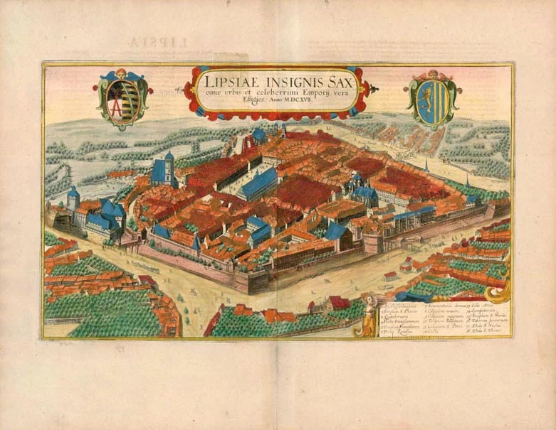
TRANSLATION OF CARTOUCHE TEXT: True likeness of the highly famed market city of Leipzig in Saxony. In the year 1617.
COMMENTARY BY BRAUN: "Leipzig is the capital of the Margravate of Meissen and lies at the confluence of the Elster and the Pleisse. It has two handsome parish churches, two elementary schools, a court of lay assessors and a regional court. A particular embellishment of the city is the university. First, however, I must warn students who are considering coming here. Not long ago, a nobleman came to Leipzig and enquired about his cousin and whether he was applying himself assiduously to his studies. A fellow student answered that he was holding his own very well, for among the 1,500 students, no one could drink better than him. But this is a bad reputation, especially unbecoming for a student."
The first plate of Leipzig shows the city around 1570 from a shallow position, with three horse riders in the left foreground as a reference to the horse market. After receiving market privileges in 1165, Leipzig developed into a leading trade-fair centre, achieving fame across Europe after being awarded imperial trade-fair rights in 1497.
This second plate, executed 50 years later, is an unusual combination of a cavalier perspective and a bird's-eye view. As a result, the viewer has the feeling of floating above the roofs. This plate is based on an official drawing by Konrad Knobloch commissioned by the Leipzig City Council. This explains why churches, public buildings, and townhouses are accurately represented with architectural details. Shortly before the first plate, there had been significant changes in Leipzig's buildings. After the siege and destruction of parts of the fortifications in 1547, a new fortress was begun under Elector Maurice of Saxony. This project culminated in the newly built Pleissenburg castle. In the 16th and 17th centuries, Leipzig was a medium-sized city with a university (visible on the right), founded in 1408-9 by scholars who had left the University of Prague. In 1620, it had a population of around 15,000. From the end of the 15th century, Leipzig was also a printing and publishing industry centre. In addition, the city played an essential role in the Reformation, for the "Leipzig Disputation", a debate at Pleissenburg castle in the summer of 1519 amongst Johannes Eck, Andreas Karlstadt, Philipp Melanchton and Martin Luther, sealed Luther's final break with the papacy.
Manasse Steinberg makes the engraving after a drawing by Konrad Knobloch. (Taschen)
Braun G. & Hogenberg F. and the Civitates Orbis Terrarum.
The Civitates Orbis Terrarum, also known as the 'Braun & Hogenberg', is a six-volume town atlas and the most excellent book of town views and plans ever published: 363 engravings, sometimes beautifully coloured. It was one of the best-selling works in the last quarter of the 16th century. Georg Braun, a skilled writer, wrote the text accompanying the plans and views on the verso. Many plates were engraved after the original drawings of a professional artist, Joris Hoefnagel (1542-1600). The first volume was published in Latin in 1572 and the sixth in 1617. Frans Hogenberg, a talented engraver, created the tables for volumes I through IV, and Simon van den Neuwel made those for volumes V and VI. Other contributors were cartographers Daniel Freese and Heinrich Rantzau, who provided valuable geographical information. Works by Jacob van Deventer, Sebastian Münster, and Johannes Stumpf were also used as references. Translations appeared in German and French, making the atlas accessible to a broader audience.
Since its original publication of volume 1 in 1572, the Civitates Orbis Terrarum has left an indelible mark on the history of cartography. Seven more editions followed the first volume in 1575, 1577, 1582, 1588, 1593, 1599, and 1612. Vol.2, initially released in 1575, saw subsequent editions in 1597 and 1612. The subsequent volumes, each a treasure trove of historical insights, graced the world in 1581, 1588, 1593, 1599, and 1606. The German translation of the first volume, a testament to its widespread appeal, debuted in 1574, followed by the French edition in 1575.
Several printers were involved: Theodor Graminaeus, Heinrich von Aich, Gottfried von Kempen, Johannis Sinniger, Bertram Buchholtz, and Peter von Brachel, all of whom worked in Cologne.
Georg Braun (1541-1622)
Georg Braun, the author of the text accompanying the plans and views in the Civitates Orbis Terrarum, was born in Cologne in 1541. After his studies in Cologne, he entered the Jesuit Order as a novice, indicating his commitment to learning and intellectual pursuits. In 1561, he obtained his bachelor's degree; in 1562, he received his Magister Artium, further demonstrating his academic achievements. Although he left the Jesuit Order, he continued his studies in theology, gaining a licentiate in theology. His theological background likely influenced the content and tone of the text in the Civitates Orbis Terrarum, adding a unique perspective to the work.
Frans Hogenberg (1535-1590)
Frans Hogenberg was a Flemish and German painter, engraver, and mapmaker. He was born in Mechelen as the son of Nicolaas Hogenberg.
By the end of the 1560s, Frans Hogenberg was employed upon Abraham Ortelius's Theatrum Orbis Terrarum, published in 1570; he is named an engraver of numerous maps. In 1568, he was banned from Antwerp by the Duke of Alva and travelled to London, where he stayed a few years before emigrating to Cologne. He immediately embarked on his two most important works, the Civitates, published in 1572 and the Geschichtsblätter, which appeared in several series from 1569 until about 1587.
Thanks to large-scale projects like the Geschichtsblätter and the Civitates, Hogenberg's social circumstances improved with each passing year. He died as a wealthy man in Cologne in 1590.