
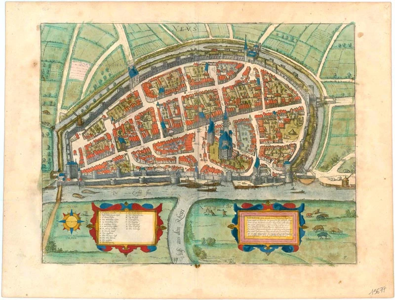
Neuss by Georg Braun & Frans Hogenberg 1612
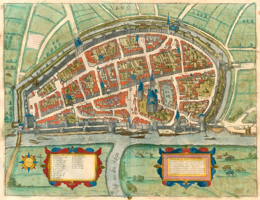


TRANSLATION OF CARTOUCHE TEXT RIGHT: The Roman king Philip captured Neuss around 1206 and gave it to Archbishop Adolph, who the Pope deposed. In 1474 the city was besieged for almost a year without success by Charles the Bold. In 1496 the main church was set on fire by lightning. In 1573 the upper street was ravaged by a fire. On 10, May 1585 Neuss was conquered by Count Neuwenarius. After being besieged for several days, Neuss was stormed and captured by the Prince of Parma on 26 July 1586. A few hours later, it was almost entirely destroyed by an unfortunate fire.
COMMENTARY BY BRAUN (on verso): "The shape of Neuss is long rather than wide, and the Erft runs along the long side before flowing into the Rhine. The city is very well protected by the river and needs no other moats. From the Rhine another sidearm flows up to the city, joining the Erft in front of the city. For this reason, even big ships with their cargoes can sail directly to the city from the Rhine."
This view from the east shows Neuss from across the Rhine, at the river's confluence with the Erft. The massive city wall was built around 1200. In 1209 building began on the minster of St Quirinus, which rises above the rest of the city on the right. It is the city's landmark and one of the most important late Romanesque churches on the Lower Rhine. In the 15th century, the city gloriously resisted a one-year siege by Charles the Bold, whereupon Emperor Frederick III granted Neuss customs exemptions, the legal status of a Hanseatic city, a new coat of arms with the imperial eagle and the imperial crown, and the right to mint and issue coins. However, the town lost its wealth and status after the Cologne War and a disastrous fire in 1586. This plate is a bird's-eye view seen from an angle of the city after being rebuilt. From the east, it gives a compact impression of the fortifications with the closely set towers, the upper and lower gates, the minster of St Quirinus and the tall, stately townhouses. (Taschen)
Braun G. & Hogenberg F. and the Civitates Orbis Terrarum.
The Civitates Orbis Terrarum, or the "Braun & Hogenberg", is a six-volume town atlas and the most excellent book of town views and plans ever published: 363 engravings, sometimes beautifully coloured. It was one of the best-selling works in the last quarter of the 16th century. Georg Braun wrote the text accompanying the plans and views on the verso. Many plates were engraved after the original drawings of a professional artist, a professional artist, Joris Hoefnagel (1542-1600). The first volume was published in Latin in 1572, and the sixth in 1617. Frans Hogenberg created the tables for volumes I through IV, and Simon van den Neuwel made those for volumes V and VI. Other contributors were cartographers Daniel Freese and Heinrich Rantzau. Works by Jacob van Deventer, Sebastian Münster, and Johannes Stumpf were also used. Translations appeared in German and French.
Following the original publication of Volume 1 of the Civitates in 1572, seven further editions of 1575, 1577, 1582, 1588, 1593, 1599 and 1612 can be identified. Vol.2, first issued in 1575, was followed by further editions in 1597 and 1612. The subsequent volumes appeared in 1581, 1588, 1593, 1599 and 1606. The German translation of the first volume appeared from 1574 on, and the French edition from 1575 on.
Several printers were involved: Theodor Graminaeus, Heinrich von Aich, Gottfried von Kempen, Johannis Sinniger, Bertram Buchholtz and Peter von Brachel, who all worked in Cologne.
Georg Braun (1541-1622)
Georg Braun was born in Cologne in 1541. After his studies in Cologne, he entered the Jesuit Order as a novice. 1561, he obtained his bachelor's degree, and in 1562, he received his Magister Artium. Although he left the Jesuit Order, he studied theology, gaining a licentiate in theology.
Frans Hogenberg (1535-1590)
Frans Hogenberg was a Flemish and German painter, engraver, and mapmaker. He was born in Mechelen as the son of Nicolaas Hogenberg.
By the end of the 1560s, Frans Hogenberg was employed upon Abraham Ortelius's Theatrum Orbis Terrarum, published in 1570; he is named an engraver of numerous maps. In 1568, he was banned from Antwerp by the Duke of Alva and travelled to London, where he stayed a few years before emigrating to Cologne. He immediately embarked on his two most important works, the Civitates, published in 1572 and the Geschichtsblätter, which appeared in several series from 1569 until about 1587.
Thanks to large-scale projects like the Geschichtsblätter and the Civitates, Hogenberg's social circumstances improved with each passing year. He died as a wealthy man in Cologne in 1590.
Novesium, circa annum 1206. . .
Item Number: 15679 Authenticity Guarantee
Category: Antique maps > Europe > Germany - Cities
Old, antique bird’s-eye view plan of Neuss, by Georg Braun & Frans Hogenberg.
Title: Novesium, circa annum 1206. . .
Date of the first edition: 1588.
Date of this map: 1612.
Copper engraving, printed on paper.
Size (not including margins): 335 x 438mm (13.19 x 17.24 inches).
Verso: Latin text.
Condition: Old coloured, excellent.
Condition Rating: .
References: Van der Krogt 4, 3021; Taschen, Br. Hog., p.170; Fauser, #9804
From: Liber Quartus Urbium Praecipuarum Totius Mundi. Cologne,Petrus von Brachel, 1612. (Van der Krogt 4, 41:1.4(1612))
TRANSLATION OF CARTOUCHE TEXT RIGHT: The Roman king Philip captured Neuss around 1206 and gave it to Archbishop Adolph, who the Pope deposed. In 1474 the city was besieged for almost a year without success by Charles the Bold. In 1496 the main church was set on fire by lightning. In 1573 the upper street was ravaged by a fire. On 10, May 1585 Neuss was conquered by Count Neuwenarius. After being besieged for several days, Neuss was stormed and captured by the Prince of Parma on 26 July 1586. A few hours later, it was almost entirely destroyed by an unfortunate fire.
COMMENTARY BY BRAUN (on verso): "The shape of Neuss is long rather than wide, and the Erft runs along the long side before flowing into the Rhine. The city is very well protected by the river and needs no other moats. From the Rhine another sidearm flows up to the city, joining the Erft in front of the city. For this reason, even big ships with their cargoes can sail directly to the city from the Rhine."
This view from the east shows Neuss from across the Rhine, at the river's confluence with the Erft. The massive city wall was built around 1200. In 1209 building began on the minster of St Quirinus, which rises above the rest of the city on the right. It is the city's landmark and one of the most important late Romanesque churches on the Lower Rhine. In the 15th century, the city gloriously resisted a one-year siege by Charles the Bold, whereupon Emperor Frederick III granted Neuss customs exemptions, the legal status of a Hanseatic city, a new coat of arms with the imperial eagle and the imperial crown, and the right to mint and issue coins. However, the town lost its wealth and status after the Cologne War and a disastrous fire in 1586. This plate is a bird's-eye view seen from an angle of the city after being rebuilt. From the east, it gives a compact impression of the fortifications with the closely set towers, the upper and lower gates, the minster of St Quirinus and the tall, stately townhouses. (Taschen)
Braun G. & Hogenberg F. and the Civitates Orbis Terrarum.
The Civitates Orbis Terrarum, or the "Braun & Hogenberg", is a six-volume town atlas and the most excellent book of town views and plans ever published: 363 engravings, sometimes beautifully coloured. It was one of the best-selling works in the last quarter of the 16th century. Georg Braun wrote the text accompanying the plans and views on the verso. Many plates were engraved after the original drawings of a professional artist, a professional artist, Joris Hoefnagel (1542-1600). The first volume was published in Latin in 1572, and the sixth in 1617. Frans Hogenberg created the tables for volumes I through IV, and Simon van den Neuwel made those for volumes V and VI. Other contributors were cartographers Daniel Freese and Heinrich Rantzau. Works by Jacob van Deventer, Sebastian Münster, and Johannes Stumpf were also used. Translations appeared in German and French.
Following the original publication of Volume 1 of the Civitates in 1572, seven further editions of 1575, 1577, 1582, 1588, 1593, 1599 and 1612 can be identified. Vol.2, first issued in 1575, was followed by further editions in 1597 and 1612. The subsequent volumes appeared in 1581, 1588, 1593, 1599 and 1606. The German translation of the first volume appeared from 1574 on, and the French edition from 1575 on.
Several printers were involved: Theodor Graminaeus, Heinrich von Aich, Gottfried von Kempen, Johannis Sinniger, Bertram Buchholtz and Peter von Brachel, who all worked in Cologne.
Georg Braun (1541-1622)
Georg Braun was born in Cologne in 1541. After his studies in Cologne, he entered the Jesuit Order as a novice. 1561, he obtained his bachelor's degree, and in 1562, he received his Magister Artium. Although he left the Jesuit Order, he studied theology, gaining a licentiate in theology.
Frans Hogenberg (1535-1590)
Frans Hogenberg was a Flemish and German painter, engraver, and mapmaker. He was born in Mechelen as the son of Nicolaas Hogenberg.
By the end of the 1560s, Frans Hogenberg was employed upon Abraham Ortelius's Theatrum Orbis Terrarum, published in 1570; he is named an engraver of numerous maps. In 1568, he was banned from Antwerp by the Duke of Alva and travelled to London, where he stayed a few years before emigrating to Cologne. He immediately embarked on his two most important works, the Civitates, published in 1572 and the Geschichtsblätter, which appeared in several series from 1569 until about 1587.
Thanks to large-scale projects like the Geschichtsblätter and the Civitates, Hogenberg's social circumstances improved with each passing year. He died as a wealthy man in Cologne in 1590.