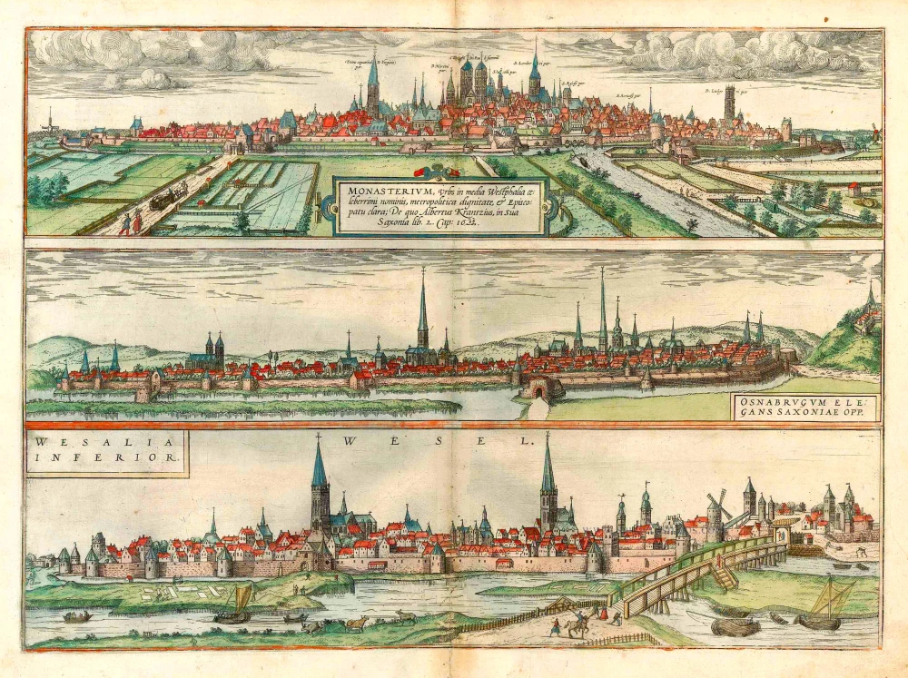
Oberwesel - Boppard, by Braun & Hogenberg. 1599
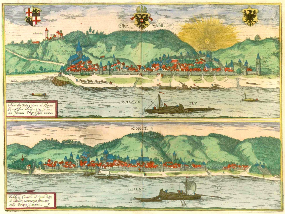

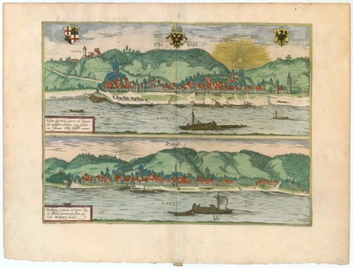
OBERWESEL
TRANSLATION OF CARTOUCHE TEXT: Accurate drawing of the town of Vosavia, or Ficelia, on the Rhine, called in the German tongue Oberwesel.
COMMENTARY BY BRAUN (on verso): "Oberwesel lies on the left bank of the Rhine and was earlier under the direct authority of the Holy Roman Emperor, after in former times having been subject to the Burgraves of Schönburg. [...] At the present time Oberwesel is still under the authority of the archbishop of Trier."
This is a view of Oberwesel looking across the Rhine in a southwesterly direction. The town is built on a hill and the most prominent building is the 14th-century Gothic church of Our Lady on its outskirts. Above it to the left is the castle of Schönburg, which was expanded around 1300 and is dominated by the Barbarossa tower. The unfinished Romanesque tower of St Martin can be seen beneath the setting sun.The walls dating from the 13th-15th centuries allow space for future expansion of the city. Beside the Rhine is the towpath with horses pulling boats up the river. The imperial eagles in the town's coat of arms indicate its status as a former Free Imperial City, which Oberwesel enjoyed in the 13th/14th centuries, before passing to the archbishopric of Trier.
BOPPARD
TRANSLATION OF CARTOUCHE TEXT: The very pleasant location of the town of Bodobriga, which today is called Boppard, on the bank of the Rhine.
COMMENTARY BY BRAUN (on verso): "Drusus built more than 50 castles and small towns on the bank of the Rhine, one of which was Boppard. In the opinion of many scholars this is attested by the extremely old square buildings and the round fortified structures in the walls, which however are not higher than the walls, without towers and flat on the top."
This view of the well-fortified town of Boppard looks towards the south from the right bank of the Rhine with the Hunsrück Foothills in the background. The walls were built in the 12th/13th centuries and replaced part of the Roman fortifications. The late Romanesque church of St Severus with its two towers rises up out of the closely packed houses in the town. To the right of it is the late Gothic collegiate church, identifiable by its thin spire. Founded in the 1st century BC as the Roman fortress of Bodobriga, and rebuilt in the 4th century AD, Boppard today has the best-preserved Roman fortifications in Germany. A Free Imperial City in the 13th century, Boppard passed to the Electorate of Trier in 1306, whose powerful Prince-Bishop Baldwin built a fortress around 1340, which is visible in the far left background, between the customs wall and the city wall. (Taschen)
Braun G. & Hogenberg F. and the Civitates Orbis Terrarum.
The Civitates Orbis Terrarum, also known as the 'Braun & Hogenberg', is a six-volume town atlas and the most excellent book of town views and plans ever published: 363 engravings, sometimes beautifully coloured. It was one of the best-selling works in the last quarter of the 16th century. Georg Braun, a skilled writer, wrote the text accompanying the plans and views on the verso. Many plates were engraved after the original drawings of a professional artist, Joris Hoefnagel (1542-1600). The first volume was published in Latin in 1572 and the sixth in 1617. Frans Hogenberg, a talented engraver, created the tables for volumes I through IV, and Simon van den Neuwel made those for volumes V and VI. Other contributors were cartographers Daniel Freese and Heinrich Rantzau, who provided valuable geographical information. Works by Jacob van Deventer, Sebastian Münster, and Johannes Stumpf were also used as references. Translations appeared in German and French, making the atlas accessible to a wider audience.
Since its original publication of volume 1 in 1572, the Civitates Orbis Terrarum has left an indelible mark on the history of cartography. The first volume was followed by seven more editions in 1575, 1577, 1582, 1588, 1593, 1599, and 1612. Vol.2, initially released in 1575, saw subsequent editions in 1597 and 1612. The subsequent volumes, each a treasure trove of historical insights, graced the world in 1581, 1588, 1593, 1599, and 1606. The German translation of the first volume, a testament to its widespread appeal, debuted in 1574, followed by the French edition in 1575.
Several printers were involved: Theodor Graminaeus, Heinrich von Aich, Gottfried von Kempen, Johannis Sinniger, Bertram Buchholtz, and Peter von Brachel, all of whom worked in Cologne.
Georg Braun (1541-1622)
Georg Braun, the author of the text accompanying the plans and views in the Civitates Orbis Terrarum, was born in Cologne in 1541. After his studies in Cologne, he entered the Jesuit Order as a novice, indicating his commitment to learning and intellectual pursuits. In 1561, he obtained his bachelor's degree; in 1562, he received his Magister Artium, further demonstrating his academic achievements. Although he left the Jesuit Order, he continued his studies in theology, gaining a licentiate in theology. His theological background likely influenced the content and tone of the text in the Civitates Orbis Terrarum, adding a unique perspective to the work.
Frans Hogenberg (1535-1590)
Frans Hogenberg was a Flemish and German painter, engraver, and mapmaker. He was born in Mechelen as the son of Nicolaas Hogenberg.
By the end of the 1560s, Frans Hogenberg was employed upon Abraham Ortelius's Theatrum Orbis Terrarum, published in 1570; he is named an engraver of numerous maps. In 1568, he was banned from Antwerp by the Duke of Alva and travelled to London, where he stayed a few years before emigrating to Cologne. He immediately embarked on his two most important works, the Civitates, published in 1572 and the Geschichtsblätter, which appeared in several series from 1569 until about 1587.
Thanks to large-scale projects like the Geschichtsblätter and the Civitates, Hogenberg's social circumstances improved with each passing year. He died as a wealthy man in Cologne in 1590.
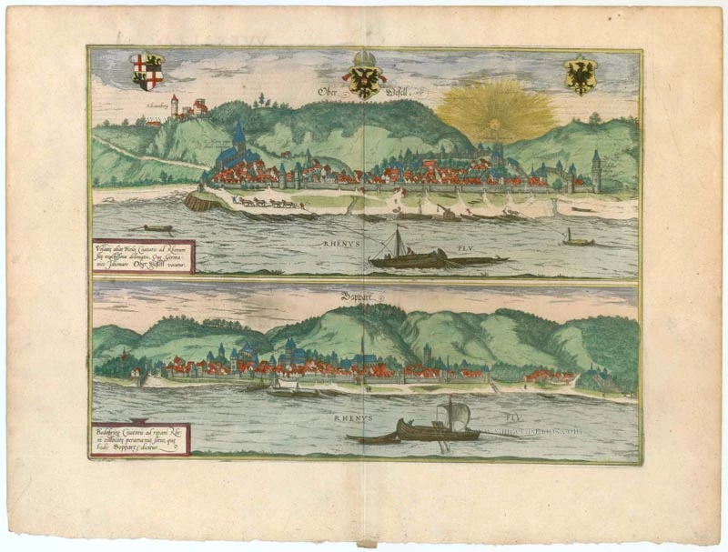
Ober Wesell [on sheet with] Boppart.
Item Number: 22268 Authenticity Guarantee
Category: Antique maps > Europe > Germany - Cities
Antique map with two bird's-eye views by Braun and Hogenberg: Oberwesel and Boppard.
Title: Ober Wesell [on sheet with] Boppart.
Date of the first edition: 1588.
Date of this map: 1599.
Copper engraving, printed on paper.
Size (not including margins): 325 x 430mm (12.8 x 16.93 inches).
Verso: Latin text.
Condition: Original coloured, excellent.
Condition Rating: A+.
From: Liber quartus Urbium Praecipuarum totius Mundi. Cologne, Bertram Buchholtz, 1599. (Van der Krogt 4, 41:1.4(1599))
OBERWESEL
TRANSLATION OF CARTOUCHE TEXT: Accurate drawing of the town of Vosavia, or Ficelia, on the Rhine, called in the German tongue Oberwesel.
COMMENTARY BY BRAUN (on verso): "Oberwesel lies on the left bank of the Rhine and was earlier under the direct authority of the Holy Roman Emperor, after in former times having been subject to the Burgraves of Schönburg. [...] At the present time Oberwesel is still under the authority of the archbishop of Trier."
This is a view of Oberwesel looking across the Rhine in a southwesterly direction. The town is built on a hill and the most prominent building is the 14th-century Gothic church of Our Lady on its outskirts. Above it to the left is the castle of Schönburg, which was expanded around 1300 and is dominated by the Barbarossa tower. The unfinished Romanesque tower of St Martin can be seen beneath the setting sun.The walls dating from the 13th-15th centuries allow space for future expansion of the city. Beside the Rhine is the towpath with horses pulling boats up the river. The imperial eagles in the town's coat of arms indicate its status as a former Free Imperial City, which Oberwesel enjoyed in the 13th/14th centuries, before passing to the archbishopric of Trier.
BOPPARD
TRANSLATION OF CARTOUCHE TEXT: The very pleasant location of the town of Bodobriga, which today is called Boppard, on the bank of the Rhine.
COMMENTARY BY BRAUN (on verso): "Drusus built more than 50 castles and small towns on the bank of the Rhine, one of which was Boppard. In the opinion of many scholars this is attested by the extremely old square buildings and the round fortified structures in the walls, which however are not higher than the walls, without towers and flat on the top."
This view of the well-fortified town of Boppard looks towards the south from the right bank of the Rhine with the Hunsrück Foothills in the background. The walls were built in the 12th/13th centuries and replaced part of the Roman fortifications. The late Romanesque church of St Severus with its two towers rises up out of the closely packed houses in the town. To the right of it is the late Gothic collegiate church, identifiable by its thin spire. Founded in the 1st century BC as the Roman fortress of Bodobriga, and rebuilt in the 4th century AD, Boppard today has the best-preserved Roman fortifications in Germany. A Free Imperial City in the 13th century, Boppard passed to the Electorate of Trier in 1306, whose powerful Prince-Bishop Baldwin built a fortress around 1340, which is visible in the far left background, between the customs wall and the city wall. (Taschen)
Braun G. & Hogenberg F. and the Civitates Orbis Terrarum.
The Civitates Orbis Terrarum, also known as the 'Braun & Hogenberg', is a six-volume town atlas and the most excellent book of town views and plans ever published: 363 engravings, sometimes beautifully coloured. It was one of the best-selling works in the last quarter of the 16th century. Georg Braun, a skilled writer, wrote the text accompanying the plans and views on the verso. Many plates were engraved after the original drawings of a professional artist, Joris Hoefnagel (1542-1600). The first volume was published in Latin in 1572 and the sixth in 1617. Frans Hogenberg, a talented engraver, created the tables for volumes I through IV, and Simon van den Neuwel made those for volumes V and VI. Other contributors were cartographers Daniel Freese and Heinrich Rantzau, who provided valuable geographical information. Works by Jacob van Deventer, Sebastian Münster, and Johannes Stumpf were also used as references. Translations appeared in German and French, making the atlas accessible to a wider audience.
Since its original publication of volume 1 in 1572, the Civitates Orbis Terrarum has left an indelible mark on the history of cartography. The first volume was followed by seven more editions in 1575, 1577, 1582, 1588, 1593, 1599, and 1612. Vol.2, initially released in 1575, saw subsequent editions in 1597 and 1612. The subsequent volumes, each a treasure trove of historical insights, graced the world in 1581, 1588, 1593, 1599, and 1606. The German translation of the first volume, a testament to its widespread appeal, debuted in 1574, followed by the French edition in 1575.
Several printers were involved: Theodor Graminaeus, Heinrich von Aich, Gottfried von Kempen, Johannis Sinniger, Bertram Buchholtz, and Peter von Brachel, all of whom worked in Cologne.
Georg Braun (1541-1622)
Georg Braun, the author of the text accompanying the plans and views in the Civitates Orbis Terrarum, was born in Cologne in 1541. After his studies in Cologne, he entered the Jesuit Order as a novice, indicating his commitment to learning and intellectual pursuits. In 1561, he obtained his bachelor's degree; in 1562, he received his Magister Artium, further demonstrating his academic achievements. Although he left the Jesuit Order, he continued his studies in theology, gaining a licentiate in theology. His theological background likely influenced the content and tone of the text in the Civitates Orbis Terrarum, adding a unique perspective to the work.
Frans Hogenberg (1535-1590)
Frans Hogenberg was a Flemish and German painter, engraver, and mapmaker. He was born in Mechelen as the son of Nicolaas Hogenberg.
By the end of the 1560s, Frans Hogenberg was employed upon Abraham Ortelius's Theatrum Orbis Terrarum, published in 1570; he is named an engraver of numerous maps. In 1568, he was banned from Antwerp by the Duke of Alva and travelled to London, where he stayed a few years before emigrating to Cologne. He immediately embarked on his two most important works, the Civitates, published in 1572 and the Geschichtsblätter, which appeared in several series from 1569 until about 1587.
Thanks to large-scale projects like the Geschichtsblätter and the Civitates, Hogenberg's social circumstances improved with each passing year. He died as a wealthy man in Cologne in 1590.