Penig, by Braun & Hogenberg. 1618
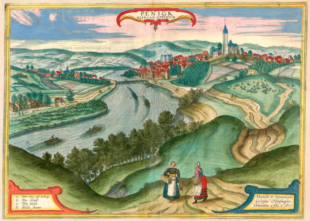
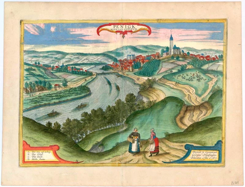


CARTOUCHE TOP: Penig, town in Meissen.
CARTOUCHE BOTTOM RIGHT: Painted and provided by Georg Hoefnagel; drawn by his son in 1617.
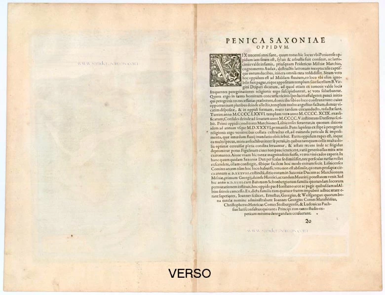
COMMENTARY BY BRAUN (on verso): "Scarcely 300 years ago, this whole area was a nest of robbers and murderers until finally Margrave Frederick of Meissen cleared and liberated all the highways and byways in his land. This town lies on the Mulde, where a chapel dedicated to Our Lady once stood, to which many visitors and pilgrims from distant countries came. When some people noticed that there were benefits to be obtained from the great number of pilgrims, they settled here to provide them hospitality. In this way, the pilgrimage and the town grew steadily. A fine church was built in place of the chapel, houses were constructed in an orderly manner and divided into streets, and finally, a wall was built, thus turning the village into a town."
This view, captured from a hill to the west of the town, showcases Penig's strategic location in a meander of the navigable Zwickauer Mulde (D). The late Gothic parish church of Our Lady on the Mountain (C), consecrated in 1515, dominates the scene. In the pre-Reformation era, from the 12th century onwards, this was a renowned site of Marian Pilgrimage in Saxony. On the left, across the Mulde, is Old Penig with the Romanesque church of St Giles. The town wall, a testament to Penig's history, was constructed in the mid-15th century. The 16th-century Renaissance New Castle (B), home to the Counts of Leisnitz and Schönberg, stands tall above the houses of the burghers and artisans. Notably, Penig is positioned on the former Prague-Chemnitz-Magdeburg trade route, a fact that underscores its historical trade significance, first recorded in 1301.
Braun G. & Hogenberg F. and the Civitates Orbis Terrarum.
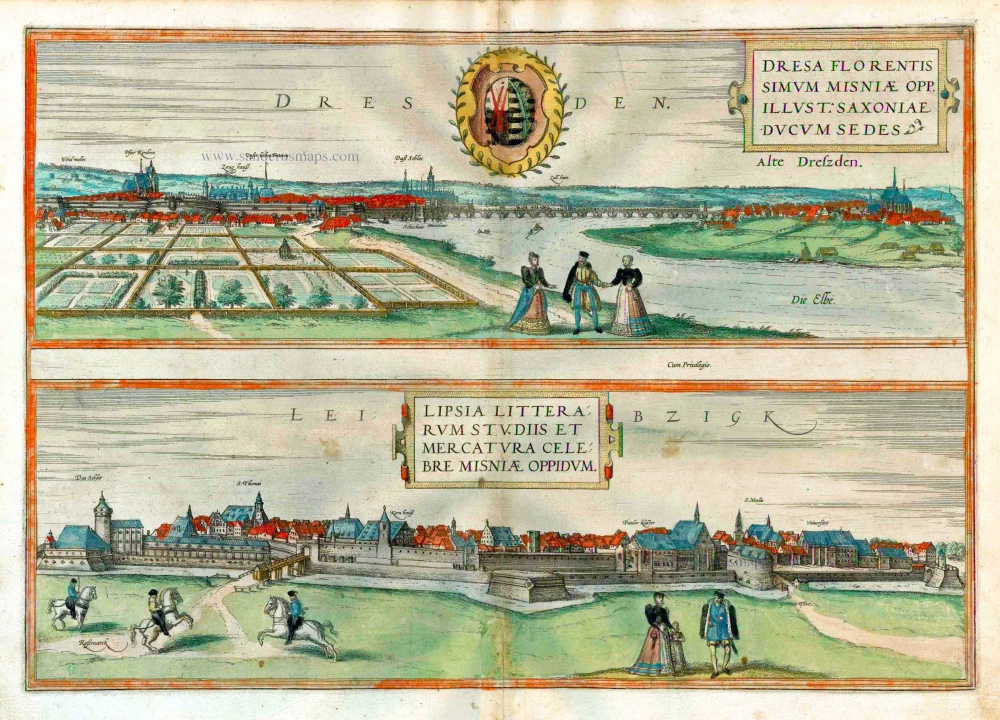
The Civitates Orbis Terrarum, also known as the 'Braun & Hogenberg', is a six-volume town atlas and the most excellent book of town views and plans ever published: 363 engravings, sometimes beautifully coloured. It was one of the best-selling works in the last quarter of the 16th century. Georg Braun, a skilled writer, wrote the text accompanying the plans and views on the verso. Many plates were engraved after the original drawings of a professional artist, Joris Hoefnagel (1542-1600). The first volume was published in Latin in 1572 and the sixth in 1617. Frans Hogenberg, a talented engraver, created the tables for volumes I through IV, and Simon van den Neuwel made those for volumes V and VI. Other contributors were cartographers Daniel Freese and Heinrich Rantzau, who provided valuable geographical information. Works by Jacob van Deventer, Sebastian Münster, and Johannes Stumpf were also used as references. Translations appeared in German and French, making the atlas accessible to a wider audience.
Since its original publication of volume 1 in 1572, the Civitates Orbis Terrarum has left an indelible mark on the history of cartography. The first volume was followed by seven more editions in 1575, 1577, 1582, 1588, 1593, 1599, and 1612. Vol.2, initially released in 1575, saw subsequent editions in 1597 and 1612. The subsequent volumes, each a treasure trove of historical insights, graced the world in 1581, 1588, 1593, 1599, and 1606. The German translation of the first volume, a testament to its widespread appeal, debuted in 1574, followed by the French edition in 1575.
Several printers were involved: Theodor Graminaeus, Heinrich von Aich, Gottfried von Kempen, Johannis Sinniger, Bertram Buchholtz, and Peter von Brachel, all of whom worked in Cologne.
Georg Braun (1541-1622)
Georg Braun, the author of the text accompanying the plans and views in the Civitates Orbis Terrarum, was born in Cologne in 1541. After his studies in Cologne, he entered the Jesuit Order as a novice, indicating his commitment to learning and intellectual pursuits. In 1561, he obtained his bachelor's degree; in 1562, he received his Magister Artium, further demonstrating his academic achievements. Although he left the Jesuit Order, he continued his studies in theology, gaining a licentiate in theology. His theological background likely influenced the content and tone of the text in the Civitates Orbis Terrarum, adding a unique perspective to the work.
Frans Hogenberg (1535-1590)
Frans Hogenberg was a Flemish and German painter, engraver, and mapmaker. He was born in Mechelen as the son of Nicolaas Hogenberg.
By the end of the 1560s, Frans Hogenberg was employed upon Abraham Ortelius's Theatrum Orbis Terrarum, published in 1570; he is named an engraver of numerous maps. In 1568, he was banned from Antwerp by the Duke of Alva and travelled to London, where he stayed a few years before emigrating to Cologne. He immediately embarked on his two most important works, the Civitates, published in 1572 and the Geschichtsblätter, which appeared in several series from 1569 until about 1587.
Thanks to large-scale projects like the Geschichtsblätter and the Civitates, Hogenberg's social circumstances improved with each passing year. He died as a wealthy man in Cologne in 1590.
Penigk Misniae Oppidum
Item Number: 23425 Authenticity Guarantee
Category: Antique maps > Europe > Germany - Cities
Penig, by Braun & Hogenberg.
Title: Penigk Misniae Oppidum.
Date of the first edition: 1617.
Date of this map: 1618.
Copper engraving, printed on paper.
Image size: 330 x 465mm (12.99 x 18.31 inches).
Sheet size: 415 x 535mm (16.34 x 21.06 inches).
Verso: Latin text.
Condition: Excellent, superb old colour.
Condition Rating: A+.
From: Theatri praecipuarum Totius Mundi Urbium Liber Sextus Anno MDCXVIII. (Van der Krogt 4, 41:1.6)
CARTOUCHE TOP: Penig, town in Meissen.
CARTOUCHE BOTTOM RIGHT: Painted and provided by Georg Hoefnagel; drawn by his son in 1617.
COMMENTARY BY BRAUN (on verso): "Scarcely 300 years ago, this whole area was a nest of robbers and murderers until finally Margrave Frederick of Meissen cleared and liberated all the highways and byways in his land. This town lies on the Mulde, where a chapel dedicated to Our Lady once stood, to which many visitors and pilgrims from distant countries came. When some people noticed that there were benefits to be obtained from the great number of pilgrims, they settled here to provide them hospitality. In this way, the pilgrimage and the town grew steadily. A fine church was built in place of the chapel, houses were constructed in an orderly manner and divided into streets, and finally, a wall was built, thus turning the village into a town."
This view, captured from a hill to the west of the town, showcases Penig's strategic location in a meander of the navigable Zwickauer Mulde (D). The late Gothic parish church of Our Lady on the Mountain (C), consecrated in 1515, dominates the scene. In the pre-Reformation era, from the 12th century onwards, this was a renowned site of Marian Pilgrimage in Saxony. On the left, across the Mulde, is Old Penig with the Romanesque church of St Giles. The town wall, a testament to Penig's history, was constructed in the mid-15th century. The 16th-century Renaissance New Castle (B), home to the Counts of Leisnitz and Schönberg, stands tall above the houses of the burghers and artisans. Notably, Penig is positioned on the former Prague-Chemnitz-Magdeburg trade route, a fact that underscores its historical trade significance, first recorded in 1301.
Braun G. & Hogenberg F. and the Civitates Orbis Terrarum.
The Civitates Orbis Terrarum, also known as the 'Braun & Hogenberg', is a six-volume town atlas and the most excellent book of town views and plans ever published: 363 engravings, sometimes beautifully coloured. It was one of the best-selling works in the last quarter of the 16th century. Georg Braun, a skilled writer, wrote the text accompanying the plans and views on the verso. Many plates were engraved after the original drawings of a professional artist, Joris Hoefnagel (1542-1600). The first volume was published in Latin in 1572 and the sixth in 1617. Frans Hogenberg, a talented engraver, created the tables for volumes I through IV, and Simon van den Neuwel made those for volumes V and VI. Other contributors were cartographers Daniel Freese and Heinrich Rantzau, who provided valuable geographical information. Works by Jacob van Deventer, Sebastian Münster, and Johannes Stumpf were also used as references. Translations appeared in German and French, making the atlas accessible to a wider audience.
Since its original publication of volume 1 in 1572, the Civitates Orbis Terrarum has left an indelible mark on the history of cartography. The first volume was followed by seven more editions in 1575, 1577, 1582, 1588, 1593, 1599, and 1612. Vol.2, initially released in 1575, saw subsequent editions in 1597 and 1612. The subsequent volumes, each a treasure trove of historical insights, graced the world in 1581, 1588, 1593, 1599, and 1606. The German translation of the first volume, a testament to its widespread appeal, debuted in 1574, followed by the French edition in 1575.
Several printers were involved: Theodor Graminaeus, Heinrich von Aich, Gottfried von Kempen, Johannis Sinniger, Bertram Buchholtz, and Peter von Brachel, all of whom worked in Cologne.
Georg Braun (1541-1622)
Georg Braun, the author of the text accompanying the plans and views in the Civitates Orbis Terrarum, was born in Cologne in 1541. After his studies in Cologne, he entered the Jesuit Order as a novice, indicating his commitment to learning and intellectual pursuits. In 1561, he obtained his bachelor's degree; in 1562, he received his Magister Artium, further demonstrating his academic achievements. Although he left the Jesuit Order, he continued his studies in theology, gaining a licentiate in theology. His theological background likely influenced the content and tone of the text in the Civitates Orbis Terrarum, adding a unique perspective to the work.
Frans Hogenberg (1535-1590)
Frans Hogenberg was a Flemish and German painter, engraver, and mapmaker. He was born in Mechelen as the son of Nicolaas Hogenberg.
By the end of the 1560s, Frans Hogenberg was employed upon Abraham Ortelius's Theatrum Orbis Terrarum, published in 1570; he is named an engraver of numerous maps. In 1568, he was banned from Antwerp by the Duke of Alva and travelled to London, where he stayed a few years before emigrating to Cologne. He immediately embarked on his two most important works, the Civitates, published in 1572 and the Geschichtsblätter, which appeared in several series from 1569 until about 1587.
Thanks to large-scale projects like the Geschichtsblätter and the Civitates, Hogenberg's social circumstances improved with each passing year. He died as a wealthy man in Cologne in 1590.