Ratzeburg, by Braun & Hogenberg. 1596
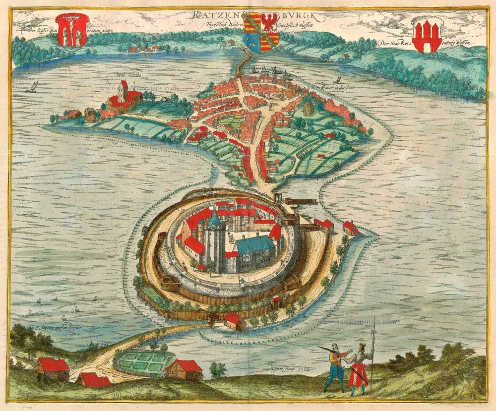
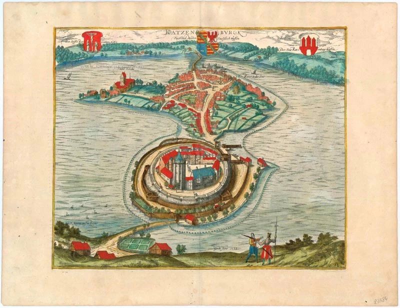


COMMENTARY BY BRAUN (on verso): "Ratzeburg is an ancient town in Saxony with a castle; it lies seven miles from Hamburg and as many from Lüneburg, two from Lübech and six miles from Schwerin, in a very convenient location surrounded entirely by water. On the island, on the north side of the town, stand the cathedral and the canons' houses. To the south lies the prince's palace, which is furnished with many buildings, with walls, ramparts and bastions, and surrounded by water on all sides, and from where the town can be reached only by carriage or on horseback via a bridge."
The engraving offers a bird's-eye view from the south of the town lying on two islands in Lake Ratzeburg. The name Ratzeburg probably derives from Ratibor, a Polabian prince who is thought to have built the castle, which is first mentioned in records in 1062. Ratzeburg was Christianized in 1154 under Count Henry of Bodewide and construction on the cathedral (Thumb Kirche) began soon afterwards, under Bishop Evermod; the three-aisled Romanesque basilica with its massive west tower is clearly visible top left. On the right, in the town, lies the church of St Peter dating from the 13th century. While a large part of the town, including the castle and most of its fortifications, were destroyed by Danish bombardment in 1693, the cathedral survived the attack. A health resort in the Duchy of Lauenburg district of Schleswig-Holstein in northern Germany, Ratzeburg today has a population of 14,000. (Taschen)
Braun G. & Hogenberg F. and the Civitates Orbis Terrarum.
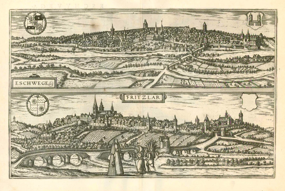
The Civitates Orbis Terrarum, also known as the 'Braun & Hogenberg', is a six-volume town atlas and the most excellent book of town views and plans ever published: 363 engravings, sometimes beautifully coloured. It was one of the best-selling works in the last quarter of the 16th century. Georg Braun, a skilled writer, wrote the text accompanying the plans and views on the verso. Many plates were engraved after the original drawings of a professional artist, Joris Hoefnagel (1542-1600). The first volume was published in Latin in 1572 and the sixth in 1617. Frans Hogenberg, a talented engraver, created the tables for volumes I through IV, and Simon van den Neuwel made those for volumes V and VI. Other contributors were cartographers Daniel Freese and Heinrich Rantzau, who provided valuable geographical information. Works by Jacob van Deventer, Sebastian Münster, and Johannes Stumpf were also used as references. Translations appeared in German and French, making the atlas accessible to a broader audience.
Since its original publication of volume 1 in 1572, the Civitates Orbis Terrarum has left an indelible mark on the history of cartography. Seven more editions followed the first volume in 1575, 1577, 1582, 1588, 1593, 1599, and 1612. Vol.2, initially released in 1575, saw subsequent editions in 1597 and 1612. The subsequent volumes, each a treasure trove of historical insights, graced the world in 1581, 1588, 1593, 1599, and 1606. The German translation of the first volume, a testament to its widespread appeal, debuted in 1574, followed by the French edition in 1575.
Several printers were involved: Theodor Graminaeus, Heinrich von Aich, Gottfried von Kempen, Johannis Sinniger, Bertram Buchholtz, and Peter von Brachel, all of whom worked in Cologne.
Georg Braun (1541-1622)
Georg Braun, the author of the text accompanying the plans and views in the Civitates Orbis Terrarum, was born in Cologne in 1541. After his studies in Cologne, he entered the Jesuit Order as a novice, indicating his commitment to learning and intellectual pursuits. In 1561, he obtained his bachelor's degree; in 1562, he received his Magister Artium, further demonstrating his academic achievements. Although he left the Jesuit Order, he continued his studies in theology, gaining a licentiate in theology. His theological background likely influenced the content and tone of the text in the Civitates Orbis Terrarum, adding a unique perspective to the work.
Frans Hogenberg (1535-1590)
Frans Hogenberg was a Flemish and German painter, engraver, and mapmaker. He was born in Mechelen as the son of Nicolaas Hogenberg.
By the end of the 1560s, Frans Hogenberg was employed upon Abraham Ortelius's Theatrum Orbis Terrarum, published in 1570; he is named an engraver of numerous maps. In 1568, he was banned from Antwerp by the Duke of Alva and travelled to London, where he stayed a few years before emigrating to Cologne. He immediately embarked on his two most important works, the Civitates, published in 1572 and the Geschichtsblätter, which appeared in several series from 1569 until about 1587.
Thanks to large-scale projects like the Geschichtsblätter and the Civitates, Hogenberg's social circumstances improved with each passing year. He died as a wealthy man in Cologne in 1590.
Ratzenburgk
Item Number: 23384 Authenticity Guarantee
Category: Antique maps > Europe > Germany - Cities
Antique map - bird's-eye view of Ratzeburg by Braun & Hogenberg.
Signed and dated bottom centre: Gerdt Hane 1588.
Date of the first edition: 1596
Date of this map: 1596/97
Copper engraving
Size: 33 x 40cm (12.9 x 15.6 inches)
Verso text: Latin
Condition: Excellent, superb old colour.
Condition Rating: A+
References: Van der Krogt 4, 3521; Taschen, Braun and Hogenberg, p.403
From: Urbium Praecipuarum Mundi Theatrum Quintum Auctore Georgio Braunio Agrippinate. Part 5. Köln, 1596/97. (Van der Krogt 4, 41:1.5)
COMMENTARY BY BRAUN (on verso): "Ratzeburg is an ancient town in Saxony with a castle; it lies seven miles from Hamburg and as many from Lüneburg, two from Lübech and six miles from Schwerin, in a very convenient location surrounded entirely by water. On the island, on the north side of the town, stand the cathedral and the canons' houses. To the south lies the prince's palace, which is furnished with many buildings, with walls, ramparts and bastions, and surrounded by water on all sides, and from where the town can be reached only by carriage or on horseback via a bridge."
The engraving offers a bird's-eye view from the south of the town lying on two islands in Lake Ratzeburg. The name Ratzeburg probably derives from Ratibor, a Polabian prince who is thought to have built the castle, which is first mentioned in records in 1062. Ratzeburg was Christianized in 1154 under Count Henry of Bodewide and construction on the cathedral (Thumb Kirche) began soon afterwards, under Bishop Evermod; the three-aisled Romanesque basilica with its massive west tower is clearly visible top left. On the right, in the town, lies the church of St Peter dating from the 13th century. While a large part of the town, including the castle and most of its fortifications, were destroyed by Danish bombardment in 1693, the cathedral survived the attack. A health resort in the Duchy of Lauenburg district of Schleswig-Holstein in northern Germany, Ratzeburg today has a population of 14,000. (Taschen)
Braun G. & Hogenberg F. and the Civitates Orbis Terrarum.
The Civitates Orbis Terrarum, also known as the 'Braun & Hogenberg', is a six-volume town atlas and the most excellent book of town views and plans ever published: 363 engravings, sometimes beautifully coloured. It was one of the best-selling works in the last quarter of the 16th century. Georg Braun, a skilled writer, wrote the text accompanying the plans and views on the verso. Many plates were engraved after the original drawings of a professional artist, Joris Hoefnagel (1542-1600). The first volume was published in Latin in 1572 and the sixth in 1617. Frans Hogenberg, a talented engraver, created the tables for volumes I through IV, and Simon van den Neuwel made those for volumes V and VI. Other contributors were cartographers Daniel Freese and Heinrich Rantzau, who provided valuable geographical information. Works by Jacob van Deventer, Sebastian Münster, and Johannes Stumpf were also used as references. Translations appeared in German and French, making the atlas accessible to a broader audience.
Since its original publication of volume 1 in 1572, the Civitates Orbis Terrarum has left an indelible mark on the history of cartography. Seven more editions followed the first volume in 1575, 1577, 1582, 1588, 1593, 1599, and 1612. Vol.2, initially released in 1575, saw subsequent editions in 1597 and 1612. The subsequent volumes, each a treasure trove of historical insights, graced the world in 1581, 1588, 1593, 1599, and 1606. The German translation of the first volume, a testament to its widespread appeal, debuted in 1574, followed by the French edition in 1575.
Several printers were involved: Theodor Graminaeus, Heinrich von Aich, Gottfried von Kempen, Johannis Sinniger, Bertram Buchholtz, and Peter von Brachel, all of whom worked in Cologne.
Georg Braun (1541-1622)
Georg Braun, the author of the text accompanying the plans and views in the Civitates Orbis Terrarum, was born in Cologne in 1541. After his studies in Cologne, he entered the Jesuit Order as a novice, indicating his commitment to learning and intellectual pursuits. In 1561, he obtained his bachelor's degree; in 1562, he received his Magister Artium, further demonstrating his academic achievements. Although he left the Jesuit Order, he continued his studies in theology, gaining a licentiate in theology. His theological background likely influenced the content and tone of the text in the Civitates Orbis Terrarum, adding a unique perspective to the work.
Frans Hogenberg (1535-1590)
Frans Hogenberg was a Flemish and German painter, engraver, and mapmaker. He was born in Mechelen as the son of Nicolaas Hogenberg.
By the end of the 1560s, Frans Hogenberg was employed upon Abraham Ortelius's Theatrum Orbis Terrarum, published in 1570; he is named an engraver of numerous maps. In 1568, he was banned from Antwerp by the Duke of Alva and travelled to London, where he stayed a few years before emigrating to Cologne. He immediately embarked on his two most important works, the Civitates, published in 1572 and the Geschichtsblätter, which appeared in several series from 1569 until about 1587.
Thanks to large-scale projects like the Geschichtsblätter and the Civitates, Hogenberg's social circumstances improved with each passing year. He died as a wealthy man in Cologne in 1590.